831:"}},"text\/plain":{"en":{"":"coordinates of the point of view"}}},"{\"value\":{\"latitude\":52.99733,\"longitude\":-1.1598,\"altitude\":null,\"precision\":1.0e-5,\"globe\":\"http:\\\/\\\/www.wikidata.org\\\/entity\\\/Q2\"},\"type\":\"globecoordinate\"}":{"text\/html":{"en":{"P1259":"52\u00b059'50.39"N, 1\u00b09'35.28"W"}},"text\/plain":{"en":{"P1259":"52\u00b059'50.39\"N, 1\u00b09'35.28\"W"}}},"{\"value\":{\"entity-type\":\"property\",\"numeric-id\":7787,\"id\":\"P7787\"},\"type\":\"wikibase-entityid\"}":{"text\/html":{"en":{"":"
943:"}},"text\/plain":{"en":{"":"coordinates of depicted place"}}},"{\"value\":{\"latitude\":52.99796,\"longitude\":-1.1597,\"altitude\":null,\"precision\":1.0e-5,\"globe\":\"http:\\\/\\\/www.wikidata.org\\\/entity\\\/Q2\"},\"type\":\"globecoordinate\"}":{"text\/html":{"en":{"P9149":"52\u00b059'52.66"N, 1\u00b09'34.92"W"}},"text\/plain":{"en":{"P9149":"52\u00b059'52.66\"N, 1\u00b09'34.92\"W"}}},"{\"value\":{\"entity-type\":\"property\",\"numeric-id\":7787,\"id\":\"P7787\"},\"type\":\"wikibase-entityid\"}":{"text\/html":{"en":{"":"
483:"}},"text\/plain":{"en":{"":"author name string"}}},"{\"value\":\"Alan Murray-Rust\",\"type\":\"string\"}":{"text\/html":{"en":{"P2093":"Alan Murray-Rust"}},"text\/plain":{"en":{"P2093":"Alan Murray-Rust"}}},"{\"value\":{\"entity-type\":\"property\",\"numeric-id\":2699,\"id\":\"P2699\"},\"type\":\"wikibase-entityid\"}":{"text\/html":{"en":{"":"
793:"}},"text\/plain":{"en":{"":"inception"}}},"{\"value\":{\"time\":\"+2009-03-15T00:00:00Z\",\"timezone\":0,\"before\":0,\"after\":0,\"precision\":11,\"calendarmodel\":\"http:\\\/\\\/www.wikidata.org\\\/entity\\\/Q1985727\"},\"type\":\"time\"}":{"text\/html":{"en":{"P571":"15 March 2009"}},"text\/plain":{"en":{"P571":"15 March 2009"}}}}": -->
670:
276:
226:
939:
218:
290:
240:
311:
349:
354:
67:
1011:"}},"text\/plain":{"en":{"":"ISO speed"}}},"{\"value\":{\"amount\":\"+100\",\"unit\":\"1\"},\"type\":\"quantity\"}":{"text\/html":{"en":{"P6789":"100"}},"text\/plain":{"en":{"P6789":"100"}}}}": -->
1094:"}},"text\/plain":{"en":{"":"f-number"}}},"{\"value\":{\"amount\":\"+6.3\",\"unit\":\"1\"},\"type\":\"quantity\"}":{"text\/html":{"en":{"P6790":"6.3"}},"text\/plain":{"en":{"P6790":"6.3"}}}}": -->
491:"}},"text\/plain":{"en":{"P2699":"https:\/\/www.geograph.org.uk\/profile\/9181"}}},"{\"value\":{\"entity-type\":\"property\",\"numeric-id\":3831,\"id\":\"P3831\"},\"type\":\"wikibase-entityid\"}":{"text\/html":{"en":{"":"
678:"}},"text\/plain":{"en":{"P7482":"file available on the internet"}}},"{\"value\":{\"entity-type\":\"property\",\"numeric-id\":137,\"id\":\"P137\"},\"type\":\"wikibase-entityid\"}":{"text\/html":{"en":{"":"
686:"}},"text\/plain":{"en":{"P137":"Geograph Britain and Ireland"}}},"{\"value\":{\"entity-type\":\"property\",\"numeric-id\":7384,\"id\":\"P7384\"},\"type\":\"wikibase-entityid\"}":{"text\/html":{"en":{"":"
495:"}},"text\/plain":{"en":{"":"object of statement has role"}}},"{\"value\":{\"entity-type\":\"item\",\"numeric-id\":33231,\"id\":\"Q33231\"},\"type\":\"wikibase-entityid\"}":{"text\/html":{"en":{"P3831":"
630:"}},"text\/plain":{"en":{"":"copyright license"}}},"{\"value\":{\"entity-type\":\"item\",\"numeric-id\":19068220,\"id\":\"Q19068220\"},\"type\":\"wikibase-entityid\"}":{"text\/html":{"en":{"P275":"
586:"}},"text\/plain":{"en":{"":"copyright status"}}},"{\"value\":{\"entity-type\":\"item\",\"numeric-id\":50423863,\"id\":\"Q50423863\"},\"type\":\"wikibase-entityid\"}":{"text\/html":{"en":{"P6216":"
674:"}},"text\/plain":{"en":{"":"source of file"}}},"{\"value\":{\"entity-type\":\"item\",\"numeric-id\":74228490,\"id\":\"Q74228490\"},\"type\":\"wikibase-entityid\"}":{"text\/html":{"en":{"P7482":"
1049:"}},"text\/plain":{"en":{"":"exposure time"}}},"{\"value\":{\"amount\":\"+0.01\",\"unit\":\"http:\\\/\\\/www.wikidata.org\\\/entity\\\/Q11574\"},\"type\":\"quantity\"}":{"text\/html":{"en":{"P6757":"0.01
899:"}},"text\/plain":{"en":{"":"captured with"}}},"{\"value\":{\"entity-type\":\"item\",\"numeric-id\":7130082,\"id\":\"Q7130082\"},\"type\":\"wikibase-entityid\"}":{"text\/html":{"en":{"P4082":"
682:"}},"text\/plain":{"en":{"":"operator"}}},"{\"value\":{\"entity-type\":\"item\",\"numeric-id\":1503119,\"id\":\"Q1503119\"},\"type\":\"wikibase-entityid\"}":{"text\/html":{"en":{"P137":"
947:"}},"text\/plain":{"en":{"":"heading"}}},"{\"value\":{\"amount\":\"+0\",\"unit\":\"http:\\\/\\\/www.wikidata.org\\\/entity\\\/Q28390\"},\"type\":\"quantity\"}":{"text\/html":{"en":{"P7787":"0
835:"}},"text\/plain":{"en":{"":"heading"}}},"{\"value\":{\"amount\":\"+0\",\"unit\":\"http:\\\/\\\/www.wikidata.org\\\/entity\\\/Q28390\"},\"type\":\"quantity\"}":{"text\/html":{"en":{"P7787":"0
694:"}},"text\/plain":{"en":{"P7384":"1206588"}}},"{\"value\":{\"entity-type\":\"property\",\"numeric-id\":973,\"id\":\"P973\"},\"type\":\"wikibase-entityid\"}":{"text\/html":{"en":{"":"
479:"}},"text\/plain":{"en":{"":"creator"}}},"{\"value\":{\"entity-type\":\"property\",\"numeric-id\":2093,\"id\":\"P2093\"},\"type\":\"wikibase-entityid\"}":{"text\/html":{"en":{"":"
1090:
698:"}},"text\/plain":{"en":{"":"described at URL"}}},"{\"value\":\"https:\\\/\\\/www.geograph.org.uk\\\/photo\\\/1206588\",\"type\":\"string\"}":{"text\/html":{"en":{"P973":"
487:"}},"text\/plain":{"en":{"":"URL"}}},"{\"value\":\"https:\\\/\\\/www.geograph.org.uk\\\/profile\\\/9181\",\"type\":\"string\"}":{"text\/html":{"en":{"P2699":"
38:
690:"}},"text\/plain":{"en":{"":"geograph.org.uk image ID"}}},"{\"value\":\"1206588\",\"type\":\"string\"}":{"text\/html":{"en":{"P7384":"
259:
209:
401:– You must give appropriate credit, provide a link to the license, and indicate if changes were made. You may do so in any reasonable manner, but not in any way that suggests the licensor endorses you or your use.
273:
223:
1187:== {{int:filedesc}} == {{Information |description={{en|1=Hartcroft Road Looking down to Beckhampton Road. The southern end of the postwar Bestwood Park Estate.}} |date=2009-03-15 |source=From |aut
691:
675:
631:
587:
900:
683:
496:
78:
1091:
1046:
1008:
944:
940:
896:
832:
828:
687:
671:
583:
492:
484:
480:
46:
699:
790:
695:
679:
627:
488:
476:
1180:
634:"}},"text\/plain":{"en":{"P275":"Creative Commons Attribution-ShareAlike 2.0 Generic"}}}}": -->
702:"}},"text\/plain":{"en":{"P973":"https:\/\/www.geograph.org.uk\/photo\/1206588"}}}}": -->
725:
657:
613:
283:
233:
926:
745:
318:
1212:
This file contains additional information, probably added from the digital camera or scanner used to create or digitize it.
408:
568:
1101:
1060:
1018:
985:
958:
910:
873:
846:
753:
709:
597:
561:
546:
533:
800:
768:
738:
641:
506:
465:
903:"}},"text\/plain":{"en":{"P4082":"Panasonic Lumix DMC-FZ7"}}}}": -->
1169:
1164:
37:
1320:
364:
1215:
If the file has been modified from its original state, some details may not fully reflect the modified file.
407:– If you remix, transform, or build upon the material, you must distribute your contributions under the
325:
on the
Geograph website for the photographer's contact details. The copyright on this image is owned by
499:"}},"text\/plain":{"en":{"P3831":"photographer"}}}}": -->
121:
Hartcroft Road
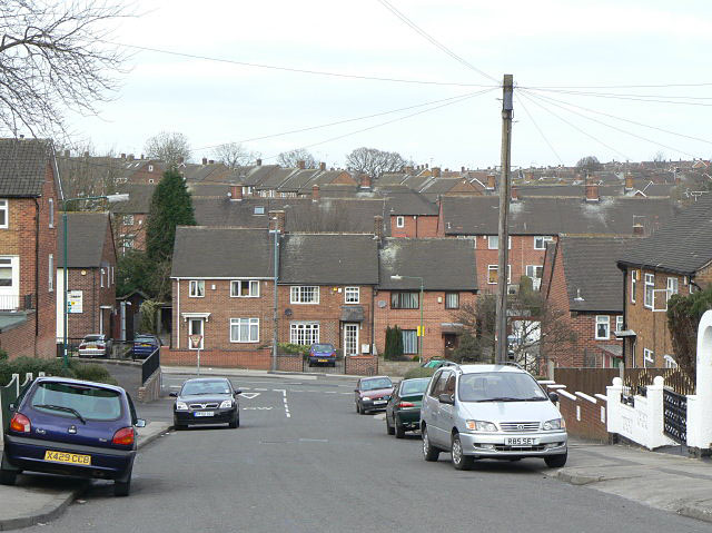
Looking down to Beckhampton Road. The southern end of the postwar Bestwood Park Estate.
1053:"}},"text\/plain":{"en":{"P6757":"0.01 second"}}}}": -->
590:"}},"text\/plain":{"en":{"P6216":"copyrighted"}}}}": -->
951:"}},"text\/plain":{"en":{"P7787":"0 degree"}}}}": -->
839:"}},"text\/plain":{"en":{"P7787":"0 degree"}}}}": -->
86:
178:
1357:
775:
760:
553:
361:
162:
8:
1367:
305:
289:
239:
330:
73:
455:
1403:
1339:
1241:
1201:
141:
1413:
151:
1111:
1070:
1028:
968:
920:
856:
810:
719:
651:
607:
516:
1377:
310:
1261:
322:
1224:
1251:
1137:
Click on a date/time to view the file as it appeared at that time.
1234:
275:
225:
260:
52° 59′ 53″ N, 1° 09′ 35″ W
210:
52° 59′ 50″ N, 1° 09′ 35″ W
130:
61:
449:
Add a one-line explanation of what this file represents
1195:
1135:
85:
Commons is a freely licensed media file repository.
658:
Creative
Commons Attribution-ShareAlike 2.0 Generic
632:
Creative
Commons Attribution-ShareAlike 2.0 Generic
1372:Flash did not fire, compulsory flash suppression
51:(640 × 479 pixels, file size: 97 KB, MIME type:
418:https://creativecommons.org/licenses/by-sa/2.0
111:Hartcroft Road - geograph.org.uk - 1206588.jpg
66:
47:Hartcroft_Road_-_geograph.org.uk_-_1206588.jpg
700:https:\/\/www.geograph.org.uk\/photo\/1206588
424:Creative Commons Attribution-Share Alike 2.0
342:
126:
108:
489:https:\/\/www.geograph.org.uk\/profile\/9181
147:
136:
14:
1050:
948:
836:
384:– to copy, distribute and transmit the work
776:https://www.geograph.org.uk/photo/1206588
554:https://www.geograph.org.uk/profile/9181
282:View this and other nearby images on:
232:View this and other nearby images on:
185:
97:
329:and is licensed for reuse under the
250:
200:
1197:The following page uses this file:
1128:
365:Attribution-Share Alike 2.0 Generic
353:
348:
333:Attribution-ShareAlike 2.0 license.
13:
1210:
454:
448:
339:
316:
115:
98:
44:
1439:
1217:
453:
1272:Date and time of data generation
847:coordinates of the point of view
829:coordinates of the point of view
439:
395:Under the following conditions:
360:This file is licensed under the
352:
347:
341:
309:
288:
274:
266:
238:
224:
216:
65:
21:
436:
116:
41:No higher resolution available.
1132:
726:file available on the internet
676:file available on the internet
435:
317:This image was taken from the
26:
1:
959:coordinates of depicted place
941:coordinates of depicted place
191:Alan Murray-Rust /
172:Alan Murray-Rust /
31:
1192:
746:Geograph Britain and Ireland
684:Geograph Britain and Ireland
562:object of statement has role
493:object of statement has role
461:Items portrayed in this file
301:
7:
1331:Date and time of digitizing
1207:
10:
1444:
974:52°59'52.66"N, 1°9'34.92"W
862:52°59'50.39"N, 1°9'35.28"W
409:same or compatible license
265:
215:
105:
100:
1304:File change date and time
1129:
16:
754:geograph.org.uk image ID
688:geograph.org.uk image ID
438:
375:
72:This is a file from the
36:
1387:Custom image processing
1186:
1165:03:35, 26 February 2011
927:Panasonic Lumix DMC-FZ7
901:Panasonic Lumix DMC-FZ7
163:required by the license
129:
76:. Information from its
323:this photograph's page
294:52.997960; -1.159700
244:52.997330; -1.159800
79:description page there
1288:Horizontal resolution
1334:13:29, 15 March 2009
1307:13:29, 15 March 2009
1275:13:29, 15 March 2009
1312:Y and C positioning
1296:Vertical resolution
1221:Camera manufacturer
390:– to adapt the work
1424:Scene capture type
1408:Auto white balance
534:author name string
481:author name string
1431:
1430:
1190:
1052:
950:
838:
642:copyright license
628:copyright license
447:
338:
337:
321:collection. See
299:
298:
249:
248:
198:
197:
166:
94:
93:
74:Wikimedia Commons
1435:
1246:1/100 sec (0.01)
1218:
1177:
1139:
1079:
996:
995:
990:
884:
883:
878:
778:
773:
769:described at URL
763:
758:
748:
743:
696:described at URL
598:copyright status
584:copyright status
571:
566:
556:
551:
541:
540:Alan Murray-Rust
538:
445:
431:
428:
425:
422:
419:
411:as the original.
373:
372:Alan Murray-Rust
362:Creative Commons
356:
355:
351:
350:
345:
344:
331:Creative Commons
327:Alan Murray-Rust
319:Geograph project
313:
306:
295:
292:
278:
277:
271:
270:
269:
263:
262:
251:
245:
242:
228:
227:
221:
220:
219:
213:
212:
201:
160:
152:Alan Murray-Rust
132:
120:
112:
106:
90:
69:
68:
62:
56:
54:
1443:
1442:
1438:
1437:
1436:
1434:
1433:
1432:
1352:5.3106994628906
1344:6.6438598632812
1206:
1191:
1183:
1175:
1131:
1130:
1127:
1126:
1125:
1124:
1123:
1122:
1121:
1120:
1118:
1108:
1107:
1106:
1104:
1089:
1088:
1087:
1086:
1085:
1084:
1083:
1082:
1080:
1077:
1067:
1066:
1065:
1063:
1044:
1043:
1042:
1041:
1040:
1039:
1038:
1037:
1035:
1025:
1024:
1023:
1021:
1006:
1005:
1004:
1003:
1002:
1001:
1000:
999:
998:
997:
993:
991:
988:
979:
978:
977:
975:
965:
964:
963:
961:
938:
937:
936:
935:
934:
933:
932:
931:
929:
917:
916:
915:
913:
894:
893:
892:
891:
890:
889:
888:
887:
886:
885:
881:
879:
876:
867:
866:
865:
863:
853:
852:
851:
849:
826:
825:
824:
823:
822:
821:
820:
819:
817:
807:
806:
805:
803:
788:
787:
786:
785:
784:
783:
782:
781:
780:
779:
774:
771:
765:
764:
759:
756:
750:
749:
744:
741:
732:
731:
730:
728:
716:
715:
714:
712:
669:
668:
667:
666:
665:
664:
663:
662:
660:
648:
647:
646:
644:
625:
624:
623:
622:
621:
620:
619:
618:
616:
604:
603:
602:
600:
581:
580:
579:
578:
577:
576:
575:
574:
573:
572:
567:
564:
558:
557:
552:
549:
543:
542:
539:
536:
527:
526:
525:
523:
513:
512:
511:
509:
474:
473:
472:
471:
470:
468:
452:
451:
450:
433:
432:
429:
426:
423:
420:
417:
416:
374:
371:
368:
357:
334:
304:
293:
267:
258:
257:
254:Object location
243:
217:
208:
207:
204:Camera location
199:
188:
181:
169:
142:geograph.org.uk
122:
110:
103:
96:
95:
84:
83:
82:is shown below.
58:
52:
50:
43:
42:
12:
11:
5:
1441:
1429:
1428:
1425:
1421:
1420:
1417:
1410:
1409:
1406:
1400:
1399:
1396:
1392:
1391:
1390:Normal process
1388:
1384:
1383:
1380:
1374:
1373:
1370:
1364:
1363:
1360:
1354:
1353:
1350:
1346:
1345:
1342:
1336:
1335:
1332:
1328:
1327:
1324:
1317:
1316:
1313:
1309:
1308:
1305:
1301:
1300:
1297:
1293:
1292:
1289:
1285:
1284:
1281:
1277:
1276:
1273:
1269:
1268:
1265:
1258:
1257:
1254:
1248:
1247:
1244:
1238:
1237:
1232:
1228:
1227:
1222:
1209:
1205:
1204:
1194:
1189:
1188:
1185:
1181:
1178:
1172:
1167:
1162:
1158:
1157:
1154:
1151:
1148:
1145:
1142:
1134:
1119:
1116:
1114:
1113:
1112:
1110:
1109:
1105:
1100:
1098:
1097:
1096:
1095:
1093:
1081:
1075:
1073:
1072:
1071:
1069:
1068:
1064:
1059:
1057:
1056:
1055:
1054:
1048:
1036:
1033:
1031:
1030:
1029:
1027:
1026:
1022:
1017:
1015:
1014:
1013:
1012:
1010:
984:
983:
982:
981:
980:
976:
973:
971:
970:
969:
967:
966:
962:
957:
955:
954:
953:
952:
946:
942:
930:
925:
923:
922:
921:
919:
918:
914:
909:
907:
906:
905:
904:
902:
898:
872:
871:
870:
869:
868:
864:
861:
859:
858:
857:
855:
854:
850:
845:
843:
842:
841:
840:
834:
830:
818:
815:
813:
812:
811:
809:
808:
804:
799:
797:
796:
795:
794:
792:
767:
766:
752:
751:
737:
736:
735:
734:
733:
729:
724:
722:
721:
720:
718:
717:
713:
710:source of file
708:
706:
705:
704:
703:
701:
697:
693:
689:
685:
681:
677:
673:
672:source of file
661:
656:
654:
653:
652:
650:
649:
645:
640:
638:
637:
636:
635:
633:
629:
617:
612:
610:
609:
608:
606:
605:
601:
596:
594:
593:
592:
591:
589:
585:
560:
559:
545:
544:
532:
531:
530:
529:
528:
524:
521:
519:
518:
517:
515:
514:
510:
505:
503:
502:
501:
500:
498:
494:
490:
486:
482:
478:
469:
464:
462:
459:
458:
457:
456:
444:
443:
440:
437:
415:
414:
413:
412:
402:
393:
392:
391:
385:
378:You are free:
369:
359:
358:
340:
336:
335:
314:
303:
300:
297:
296:
286:
280:
255:
247:
246:
236:
230:
205:
196:
195:
193:Hartcroft Road
189:
186:
183:
182:
177:
174:Hartcroft Road
170:
167:
155:
154:
149:
145:
144:
138:
134:
133:
128:
124:
123:
113:
104:
102:
99:
92:
91:
70:
60:
59:
40:
35:
34:
29:
24:
19:
9:
6:
4:
3:
2:
1440:
1426:
1423:
1422:
1418:
1415:
1412:
1411:
1407:
1405:
1404:White balance
1402:
1401:
1398:Auto exposure
1397:
1395:Exposure mode
1394:
1393:
1389:
1386:
1385:
1381:
1379:
1376:
1375:
1371:
1369:
1366:
1365:
1361:
1359:
1358:Exposure bias
1356:
1355:
1351:
1349:APEX aperture
1348:
1347:
1343:
1341:
1340:Shutter speed
1338:
1337:
1333:
1330:
1329:
1325:
1322:
1319:
1318:
1314:
1311:
1310:
1306:
1303:
1302:
1298:
1295:
1294:
1290:
1287:
1286:
1282:
1279:
1278:
1274:
1271:
1270:
1266:
1263:
1260:
1259:
1255:
1253:
1250:
1249:
1245:
1243:
1242:Exposure time
1240:
1239:
1236:
1233:
1230:
1229:
1226:
1223:
1220:
1219:
1216:
1213:
1203:
1202:Bestwood Park
1200:
1199:
1198:
1184:
1179:
1173:
1171:
1168:
1166:
1163:
1160:
1159:
1155:
1152:
1149:
1146:
1143:
1141:
1140:
1138:
1115:
1103:
1099:
1074:
1062:
1061:exposure time
1058:
1047:exposure time
1032:
1020:
1016:
987:
972:
960:
956:
928:
924:
912:
911:captured with
908:
897:captured with
875:
860:
848:
844:
816:15 March 2009
814:
802:
798:
777:
770:
762:
755:
747:
740:
727:
723:
711:
707:
659:
655:
643:
639:
615:
611:
599:
595:
570:
563:
555:
548:
535:
520:
508:
504:
467:
463:
460:
441:
434:
421:CC BY-SA 2.0
410:
406:
403:
400:
397:
396:
394:
389:
386:
383:
380:
379:
377:
376:
370:Attribution:
366:
363:
346:
332:
328:
324:
320:
315:
312:
308:
307:
291:
287:
285:
284:OpenStreetMap
281:
279:
261:
256:
253:
252:
241:
237:
235:
234:OpenStreetMap
231:
229:
211:
206:
203:
202:
194:
190:
184:
180:
176: /
175:
171:
164:
159:
157:
156:
153:
150:
146:
143:
139:
135:
131:15 March 2009
125:
119:
114:
107:
88:
81:
80:
75:
71:
64:
63:
57:
48:
39:
33:
30:
28:
25:
23:
20:
18:
15:
1414:Digital zoom
1231:Camera model
1214:
1211:
1196:
1136:
1133:File history
569:photographer
497:photographer
404:
398:
387:
381:
326:
264:
214:
192:
179:CC BY-SA 2.0
173:
117:
87:You can help
77:
45:
22:File history
1378:Color space
1280:Orientation
1182:GeographBot
614:copyrighted
588:copyrighted
405:share alike
399:attribution
158:Attribution
109:Description
1193:File usage
1174:640 × 479
1150:Dimensions
522:some value
53:image/jpeg
27:File usage
1262:ISO speed
1225:Panasonic
1147:Thumbnail
1144:Date/Time
1019:ISO speed
1009:ISO speed
801:inception
791:inception
302:Licensing
187:InfoField
168:InfoField
118:English:
1427:Standard
1315:Centered
1252:F-number
1208:Metadata
1102:f-number
1092:f-number
739:operator
680:operator
442:Captions
388:to remix
382:to share
367:license.
32:Metadata
1323:version
1235:DMC-FZ7
1176:(97 KB)
1161:current
1156:Comment
986:heading
945:heading
874:heading
833:heading
761:1206588
692:1206588
507:creator
477:creator
466:depicts
446:English
101:Summary
49:
1299:72 dpi
1291:72 dpi
1283:Normal
1264:rating
1078:second
1051:second
994:degree
949:degree
882:degree
837:degree
272:
222:
148:Author
137:Source
1416:ratio
1368:Flash
1256:f/6.3
1076:0.01
140:From
1382:sRGB
1321:Exif
1153:User
430:true
427:true
127:Date
17:File
1326:2.2
1267:100
1117:6.3
1034:100
547:URL
485:URL
992:0
989::
880:0
877::
772::
757::
742::
565::
550::
537::
1419:0
1362:0
165:)
161:(
89:.
55:)
_heading:0.00&language=en)
_heading:0.00&language=en)
