952:"}},"text\/plain":{"en":{"":"coordinates of the point of view"}}},"{\"value\":{\"latitude\":50.0922,\"longitude\":-5.1357,\"altitude\":null,\"precision\":1.0e-5,\"globe\":\"http:\\\/\\\/www.wikidata.org\\\/entity\\\/Q2\"},\"type\":\"globecoordinate\"}":{"text\/html":{"en":{"P1259":"50\u00b05'31.92"N, 5\u00b08'8.52"W"}},"text\/plain":{"en":{"P1259":"50\u00b05'31.92\"N, 5\u00b08'8.52\"W"}}},"{\"value\":{\"entity-type\":\"property\",\"numeric-id\":7787,\"id\":\"P7787\"},\"type\":\"wikibase-entityid\"}":{"text\/html":{"en":{"":"
1020:"}},"text\/plain":{"en":{"":"coordinates of depicted place"}}},"{\"value\":{\"latitude\":50.0922,\"longitude\":-5.135,\"altitude\":null,\"precision\":0.0001,\"globe\":\"http:\\\/\\\/www.wikidata.org\\\/entity\\\/Q2\"},\"type\":\"globecoordinate\"}":{"text\/html":{"en":{"P9149":"50\u00b05'31.9"N, 5\u00b08'6.0"W"}},"text\/plain":{"en":{"P9149":"50\u00b05'31.9\"N, 5\u00b08'6.0\"W"}}},"{\"value\":{\"entity-type\":\"property\",\"numeric-id\":7787,\"id\":\"P7787\"},\"type\":\"wikibase-entityid\"}":{"text\/html":{"en":{"":"
612:"}},"text\/plain":{"en":{"":"author name string"}}},"{\"value\":\"Richard Johns\",\"type\":\"string\"}":{"text\/html":{"en":{"P2093":"Richard Johns"}},"text\/plain":{"en":{"P2093":"Richard Johns"}}},"{\"value\":{\"entity-type\":\"property\",\"numeric-id\":2699,\"id\":\"P2699\"},\"type\":\"wikibase-entityid\"}":{"text\/html":{"en":{"":"
914:"}},"text\/plain":{"en":{"":"inception"}}},"{\"value\":{\"time\":\"+2002-05-19T00:00:00Z\",\"timezone\":0,\"before\":0,\"after\":0,\"precision\":11,\"calendarmodel\":\"http:\\\/\\\/www.wikidata.org\\\/entity\\\/Q1985727\"},\"type\":\"time\"}":{"text\/html":{"en":{"P571":"19 May 2002"}},"text\/plain":{"en":{"P571":"19 May 2002"}}}}": -->
791:
596:
231:
1016:
273:
223:
295:
245:
316:
354:
359:
72:
799:"}},"text\/plain":{"en":{"P7482":"file available on the internet"}}},"{\"value\":{\"entity-type\":\"property\",\"numeric-id\":7384,\"id\":\"P7384\"},\"type\":\"wikibase-entityid\"}":{"text\/html":{"en":{"":"
604:"}},"text\/plain":{"en":{"":"object of statement has role"}}},"{\"value\":{\"entity-type\":\"item\",\"numeric-id\":33231,\"id\":\"Q33231\"},\"type\":\"wikibase-entityid\"}":{"text\/html":{"en":{"P3831":"
815:"}},"text\/plain":{"en":{"P137":"Geograph Britain and Ireland"}}},"{\"value\":{\"entity-type\":\"property\",\"numeric-id\":973,\"id\":\"P973\"},\"type\":\"wikibase-entityid\"}":{"text\/html":{"en":{"":"
751:"}},"text\/plain":{"en":{"":"copyright license"}}},"{\"value\":{\"entity-type\":\"item\",\"numeric-id\":19068220,\"id\":\"Q19068220\"},\"type\":\"wikibase-entityid\"}":{"text\/html":{"en":{"P275":"
707:"}},"text\/plain":{"en":{"":"copyright status"}}},"{\"value\":{\"entity-type\":\"item\",\"numeric-id\":50423863,\"id\":\"Q50423863\"},\"type\":\"wikibase-entityid\"}":{"text\/html":{"en":{"P6216":"
795:"}},"text\/plain":{"en":{"":"source of file"}}},"{\"value\":{\"entity-type\":\"item\",\"numeric-id\":74228490,\"id\":\"Q74228490\"},\"type\":\"wikibase-entityid\"}":{"text\/html":{"en":{"P7482":"
608:"}},"text\/plain":{"en":{"P3831":"photographer"}}},"{\"value\":{\"entity-type\":\"property\",\"numeric-id\":2093,\"id\":\"P2093\"},\"type\":\"wikibase-entityid\"}":{"text\/html":{"en":{"":"
811:"}},"text\/plain":{"en":{"":"operator"}}},"{\"value\":{\"entity-type\":\"item\",\"numeric-id\":1503119,\"id\":\"Q1503119\"},\"type\":\"wikibase-entityid\"}":{"text\/html":{"en":{"P137":"
1024:"}},"text\/plain":{"en":{"":"heading"}}},"{\"value\":{\"amount\":\"+90\",\"unit\":\"http:\\\/\\\/www.wikidata.org\\\/entity\\\/Q28390\"},\"type\":\"quantity\"}":{"text\/html":{"en":{"P7787":"90
956:"}},"text\/plain":{"en":{"":"heading"}}},"{\"value\":{\"amount\":\"+90\",\"unit\":\"http:\\\/\\\/www.wikidata.org\\\/entity\\\/Q28390\"},\"type\":\"quantity\"}":{"text\/html":{"en":{"P7787":"90
807:"}},"text\/plain":{"en":{"P7384":"9853"}}},"{\"value\":{\"entity-type\":\"property\",\"numeric-id\":137,\"id\":\"P137\"},\"type\":\"wikibase-entityid\"}":{"text\/html":{"en":{"":"
600:"}},"text\/plain":{"en":{"":"creator"}}},"{\"value\":{\"entity-type\":\"property\",\"numeric-id\":3831,\"id\":\"P3831\"},\"type\":\"wikibase-entityid\"}":{"text\/html":{"en":{"":"
703:
819:"}},"text\/plain":{"en":{"":"described at URL"}}},"{\"value\":\"https:\\\/\\\/www.geograph.org.uk\\\/photo\\\/9853\",\"type\":\"string\"}":{"text\/html":{"en":{"P973":"
616:"}},"text\/plain":{"en":{"":"URL"}}},"{\"value\":\"https:\\\/\\\/www.geograph.org.uk\\\/profile\\\/334\",\"type\":\"string\"}":{"text\/html":{"en":{"P2699":"
43:
803:"}},"text\/plain":{"en":{"":"geograph.org.uk image ID"}}},"{\"value\":\"9853\",\"type\":\"string\"}":{"text\/html":{"en":{"P7384":"
214:
264:
406:– You must give appropriate credit, provide a link to the license, and indicate if changes were made. You may do so in any reasonable manner, but not in any way that suggests the licensor endorses you or your use.
228:
278:
796:
752:
708:
812:
804:
605:
1021:
1017:
953:
949:
800:
792:
704:
613:
609:
601:
911:
816:
808:
748:
597:
83:
617:
820:
472:
51:
455:
1136:
1143:== {{int:filedesc}} == {{Information |description={{en|1=Helford Village.}} |date=2002-05-19 |source=From |author= |permission= |other_versions=
755:"}},"text\/plain":{"en":{"P275":"Creative Commons Attribution-ShareAlike 2.0 Generic"}}}}": -->
620:"}},"text\/plain":{"en":{"P2699":"https:\/\/www.geograph.org.uk\/profile\/334"}}}}": -->
823:"}},"text\/plain":{"en":{"P973":"https:\/\/www.geograph.org.uk\/photo\/9853"}}}}": -->
846:
778:
734:
288:
238:
881:
323:
1218:
This file contains additional information, probably added from the digital camera or scanner used to create or digitize it.
413:
661:
1062:
1035:
994:
967:
859:
830:
718:
682:
669:
654:
548:
921:
889:
874:
762:
627:
586:
495:
487:
1125:
1120:
369:
42:
1221:
If the file has been modified from its original state, some details may not fully reflect the modified file.
468:
412:– If you remix, transform, or build upon the material, you must distribute your contributions under the
330:
on the
Geograph website for the photographer's contact details. The copyright on this image is owned by
711:"}},"text\/plain":{"en":{"P6216":"copyrighted"}}}}": -->
1028:"}},"text\/plain":{"en":{"P7787":"90 degree"}}}}": -->
960:"}},"text\/plain":{"en":{"P7787":"90 degree"}}}}": -->
476:
91:
183:
461:
Remove redundant categories and try to put this image in the most specific category/categories
366:
167:
689:
539:
8:
896:
866:
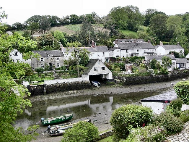
310:
543:
535:
531:
527:
523:
519:
515:
511:
507:
503:
294:
244:
1157:
335:
78:
576:
156:
1045:
977:
931:
840:
772:
728:
637:
315:
146:
1093:
Click on a date/time to view the file as it appeared at that time.
327:
1195:
280:
230:
215:
50° 05′ 31.9″ N, 5° 08′ 09″ W
265:
50° 05′ 32″ N, 5° 08′ 06″ W
135:
66:
570:
Add a one-line explanation of what this file represents
475:
combined with a database. You can also have a look at
467:
The location categories are based on information from
1205:
1151:
1185:
1175:
1166:
1091:
90:
Commons is a freely licensed media file repository.
779:
Creative
Commons Attribution-ShareAlike 2.0 Generic
753:
Creative
Commons Attribution-ShareAlike 2.0 Generic
56:(640 × 480 pixels, file size: 141 KB, MIME type:
452:The categories of this image should be checked.
423:https://creativecommons.org/licenses/by-sa/2.0
71:
429:Creative Commons Attribution-Share Alike 2.0
347:
131:
113:
152:
141:
116:Helford Village - geograph.org.uk - 9853.jpg
52:Helford_Village_-_geograph.org.uk_-_9853.jpg
14:
1025:
957:
618:https:\/\/www.geograph.org.uk\/profile\/334
389:– to copy, distribute and transmit the work
821:https:\/\/www.geograph.org.uk\/photo\/9853
1168:The following other wikis use this file:
690:https://www.geograph.org.uk/profile/334
494:This image was uploaded as part of the
897:https://www.geograph.org.uk/photo/9853
287:View this and other nearby images on:
237:View this and other nearby images on:
482:The topic category from Geograph was
190:
102:
334:and is licensed for reuse under the
255:
205:
1153:The following page uses this file:
1084:
370:Attribution-Share Alike 2.0 Generic
358:
353:
338:Attribution-ShareAlike 2.0 license.
13:
1216:
575:
569:
344:
321:
120:
103:
49:
1242:
1223:
574:
968:coordinates of the point of view
950:coordinates of the point of view
560:
445:
400:Under the following conditions:
365:This file is licensed under the
357:
352:
346:
314:
293:
279:
271:
243:
229:
221:
70:
31:
21:
557:
121:
46:No higher resolution available.
1163:
1088:
847:file available on the internet
797:file available on the internet
556:
322:This image was taken from the
26:
1:
1036:coordinates of depicted place
1018:coordinates of depicted place
36:
1148:
882:Geograph Britain and Ireland
813:Geograph Britain and Ireland
655:object of statement has role
602:object of statement has role
582:Items portrayed in this file
306:
7:
1213:
270:
220:
10:
1247:
1202:Usage on www.wikidata.org
1192:Usage on pl.wikipedia.org
1182:Usage on eu.wikipedia.org
1172:Usage on cy.wikipedia.org
414:same or compatible license
196:Richard Johns /
177:Richard Johns /
110:
105:
1085:
16:
983:50°5'31.92"N, 5°8'8.52"W
860:geograph.org.uk image ID
801:geograph.org.uk image ID
559:
477:this tool from mysociety
443:
442:
380:
77:This is a file from the
41:
1142:
473:this OpenStreetMap tool
168:required by the license
134:
81:. Information from its
1121:01:50, 30 January 2010
1051:50°5'31.9"N, 5°8'6.0"W
328:this photograph's page
299:50.092200; -5.135000
249:50.092200; -5.135700
84:description page there
496:Geograph batch upload
486:(find similar images
464:Remove this template
540:português do Brasil
395:– to adapt the work
670:author name string
610:author name string
469:this geonames tool
1234:
1233:
1164:Global file usage
1158:Helford, Cornwall
1146:
1027:
959:
763:copyright license
749:copyright license
568:
551:
498:
343:
342:
326:collection. See
304:
303:
254:
253:
203:
202:
171:
99:
98:
79:Wikimedia Commons
32:Global file usage
1238:
1224:
1133:
1095:
1073:
1072:
1067:
1005:
1004:
999:
899:
894:
890:described at URL
884:
879:
869:
864:
817:described at URL
719:copyright status
705:copyright status
692:
687:
677:
674:
664:
659:
566:
552:
547:
493:
450:
449:
448:
436:
433:
430:
427:
424:
416:as the original.
378:
367:Creative Commons
361:
360:
356:
355:
350:
349:
336:Creative Commons
324:Geograph project
318:
311:
300:
297:
283:
282:
276:
275:
274:
268:
267:
256:
250:
247:
233:
232:
226:
225:
224:
218:
217:
206:
165:
137:
126:Helford Village.
125:
117:
111:
95:
74:
73:
67:
61:
59:
1246:
1245:
1241:
1240:
1239:
1237:
1236:
1235:
1212:
1162:
1147:
1139:
1131:
1087:
1086:
1083:
1082:
1081:
1080:
1079:
1078:
1077:
1076:
1075:
1074:
1070:
1068:
1065:
1056:
1055:
1054:
1052:
1042:
1041:
1040:
1038:
1015:
1014:
1013:
1012:
1011:
1010:
1009:
1008:
1007:
1006:
1002:
1000:
997:
988:
987:
986:
984:
974:
973:
972:
970:
947:
946:
945:
944:
943:
942:
941:
940:
938:
928:
927:
926:
924:
909:
908:
907:
906:
905:
904:
903:
902:
901:
900:
895:
892:
886:
885:
880:
877:
871:
870:
865:
862:
853:
852:
851:
849:
837:
836:
835:
833:
790:
789:
788:
787:
786:
785:
784:
783:
781:
769:
768:
767:
765:
746:
745:
744:
743:
742:
741:
740:
739:
737:
725:
724:
723:
721:
702:
701:
700:
699:
698:
697:
696:
695:
694:
693:
688:
685:
679:
678:
675:
672:
666:
665:
660:
657:
648:
647:
646:
644:
634:
633:
632:
630:
595:
594:
593:
592:
591:
589:
573:
572:
571:
554:
502:
499:
456:Check them now!
446:
444:
438:
437:
434:
431:
428:
425:
422:
421:
379:
376:
373:
362:
339:
309:
298:
272:
263:
262:
259:Object location
248:
222:
213:
212:
209:Camera location
204:
198:Helford Village
193:
186:
179:Helford Village
174:
147:geograph.org.uk
127:
115:
108:
101:
100:
89:
88:
87:is shown below.
63:
57:
55:
48:
47:
12:
11:
5:
1244:
1232:
1231:
1228:
1215:
1211:
1210:
1209:
1208:
1200:
1199:
1198:
1196:Helford (wieś)
1190:
1189:
1188:
1180:
1179:
1178:
1165:
1161:
1160:
1150:
1145:
1144:
1141:
1137:
1134:
1128:
1123:
1118:
1114:
1113:
1110:
1107:
1104:
1101:
1098:
1090:
1061:
1060:
1059:
1058:
1057:
1053:
1050:
1048:
1047:
1046:
1044:
1043:
1039:
1034:
1032:
1031:
1030:
1029:
1023:
1019:
993:
992:
991:
990:
989:
985:
982:
980:
979:
978:
976:
975:
971:
966:
964:
963:
962:
961:
955:
951:
939:
936:
934:
933:
932:
930:
929:
925:
920:
918:
917:
916:
915:
913:
888:
887:
873:
872:
858:
857:
856:
855:
854:
850:
845:
843:
842:
841:
839:
838:
834:
831:source of file
829:
827:
826:
825:
824:
822:
818:
814:
810:
806:
802:
798:
794:
793:source of file
782:
777:
775:
774:
773:
771:
770:
766:
761:
759:
758:
757:
756:
754:
750:
738:
733:
731:
730:
729:
727:
726:
722:
717:
715:
714:
713:
712:
710:
706:
681:
680:
668:
667:
653:
652:
651:
650:
649:
645:
642:
640:
639:
638:
636:
635:
631:
626:
624:
623:
622:
621:
619:
615:
611:
607:
603:
599:
590:
585:
583:
580:
579:
578:
577:
565:
564:
561:
558:
492:
491:
480:
465:
462:
420:
419:
418:
417:
407:
398:
397:
396:
390:
383:You are free:
374:
364:
363:
345:
341:
340:
319:
308:
305:
302:
301:
291:
285:
260:
252:
251:
241:
235:
210:
201:
200:
194:
191:
188:
187:
182:
175:
172:
160:
159:
154:
150:
149:
143:
139:
138:
133:
129:
128:
118:
109:
107:
104:
97:
96:
75:
65:
64:
45:
40:
39:
34:
29:
24:
19:
9:
6:
4:
3:
2:
1243:
1229:
1226:
1225:
1222:
1219:
1207:
1204:
1203:
1201:
1197:
1194:
1193:
1191:
1187:
1184:
1183:
1181:
1177:
1174:
1173:
1171:
1170:
1169:
1159:
1156:
1155:
1154:
1140:
1135:
1129:
1127:
1124:
1122:
1119:
1116:
1115:
1111:
1108:
1105:
1102:
1099:
1097:
1096:
1094:
1064:
1049:
1037:
1033:
996:
981:
969:
965:
935:
923:
919:
898:
891:
883:
876:
868:
861:
848:
844:
832:
828:
780:
776:
764:
760:
736:
732:
720:
716:
691:
684:
676:Richard Johns
671:
663:
656:
641:
629:
625:
588:
584:
581:
562:
555:
553:
550:
545:
541:
537:
533:
529:
525:
521:
517:
513:
509:
505:
500:
497:
489:
485:
481:
478:
474:
470:
466:
463:
460:
459:
458:
457:
453:
441:
440:
426:CC BY-SA 2.0
415:
411:
408:
405:
402:
401:
399:
394:
391:
388:
385:
384:
382:
381:
377:Richard Johns
375:Attribution:
371:
368:
351:
337:
333:
332:Richard Johns
329:
325:
320:
317:
313:
312:
296:
292:
290:
289:OpenStreetMap
286:
284:
266:
261:
258:
257:
246:
242:
240:
239:OpenStreetMap
236:
234:
216:
211:
208:
207:
199:
195:
189:
185:
181: /
180:
176:
169:
164:
162:
161:
158:
157:Richard Johns
155:
151:
148:
144:
140:
130:
124:
119:
112:
93:
86:
85:
80:
76:
69:
68:
62:
53:
44:
38:
35:
33:
30:
28:
25:
23:
20:
18:
15:
1220:
1217:
1167:
1152:
1092:
1089:File history
662:photographer
606:photographer
501:
483:
454:
451:
439:
409:
403:
392:
386:
331:
269:
219:
197:
184:CC BY-SA 2.0
178:
122:
92:You can help
82:
50:
22:File history
1138:GeographBot
937:19 May 2002
735:copyrighted
709:copyrighted
488:at Geograph
410:share alike
404:attribution
163:Attribution
136:19 May 2002
114:Description
1227:_error
1149:File usage
1130:640 × 480
1106:Dimensions
643:some value
528:македонски
58:image/jpeg
27:File usage
1103:Thumbnail
1100:Date/Time
922:inception
912:inception
536:português
307:Licensing
192:InfoField
173:InfoField
123:English:
1214:Metadata
1206:Q5704302
1132:(141 KB)
875:operator
809:operator
563:Captions
546: |
542: |
538: |
534: |
530: |
526: |
522: |
518: |
514: |
512:français
510: |
506: |
393:to remix
387:to share
372:license.
37:Metadata
1186:Helford
1176:Helford
1117:current
1112:Comment
1063:heading
1022:heading
995:heading
954:heading
628:creator
598:creator
587:depicts
567:English
504:English
484:Village
106:Summary
54:
1071:degree
1026:degree
1003:degree
958:degree
544:Türkçe
532:മലയാളം
524:magyar
516:galego
277:
227:
153:Author
142:Source
520:עברית
508:suomi
145:From
1109:User
867:9853
805:9853
471:and
435:true
432:true
132:Date
17:File
1069:90
1001:90
683:URL
614:URL
549:+/−
1066::
998::
893::
878::
863::
686::
673::
658::
1230:0
490:)
479:.
170:)
166:(
94:.
60:)
Text is available under the Creative Commons Attribution-ShareAlike License. Additional terms may apply.
_region:GB-GBN_heading:90.00&language=en)
_heading:90.00&language=en)
