992:"}},"text\/plain":{"en":{"":"checksum"}}},"{\"value\":\"c000fccd5cd474ce45029bb89e8388623a68fb2f\",\"type\":\"string\"}":{"text\/html":{"en":{"P4092":"c000fccd5cd474ce45029bb89e8388623a68fb2f"}},"text\/plain":{"en":{"P4092":"c000fccd5cd474ce45029bb89e8388623a68fb2f"}}},"{\"value\":{\"entity-type\":\"property\",\"numeric-id\":459,\"id\":\"P459\"},\"type\":\"wikibase-entityid\"}":{"text\/html":{"en":{"":"
781:"}},"text\/plain":{"en":{"":"coordinates of depicted place"}}},"{\"value\":{\"latitude\":55.4022,\"longitude\":-3.769,\"altitude\":null,\"precision\":0.0001,\"globe\":\"http:\\\/\\\/www.wikidata.org\\\/entity\\\/Q2\"},\"type\":\"globecoordinate\"}":{"text\/html":{"en":{"P9149":"55\u00b024'7.9"N, 3\u00b046'8.4"W"}},"text\/plain":{"en":{"P9149":"55\u00b024'7.9\"N, 3\u00b046'8.4\"W"}}}}": -->
441:"}},"text\/plain":{"en":{"":"author name string"}}},"{\"value\":\"Beth Loft\",\"type\":\"string\"}":{"text\/html":{"en":{"P2093":"Beth Loft"}},"text\/plain":{"en":{"P2093":"Beth Loft"}}},"{\"value\":{\"entity-type\":\"property\",\"numeric-id\":2699,\"id\":\"P2699\"},\"type\":\"wikibase-entityid\"}":{"text\/html":{"en":{"":"
743:"}},"text\/plain":{"en":{"":"inception"}}},"{\"value\":{\"time\":\"+2003-01-01T00:00:00Z\",\"timezone\":0,\"before\":0,\"after\":0,\"precision\":9,\"calendarmodel\":\"http:\\\/\\\/www.wikidata.org\\\/entity\\\/Q1985727\"},\"type\":\"time\"}":{"text\/html":{"en":{"P571":"2003"}},"text\/plain":{"en":{"P571":"2003"}}}}": -->
620:
425:
988:
261:
299:
304:
67:
1097:
628:"}},"text\/plain":{"en":{"P7482":"file available on the internet"}}},"{\"value\":{\"entity-type\":\"property\",\"numeric-id\":7384,\"id\":\"P7384\"},\"type\":\"wikibase-entityid\"}":{"text\/html":{"en":{"":"
433:"}},"text\/plain":{"en":{"":"object of statement has role"}}},"{\"value\":{\"entity-type\":\"item\",\"numeric-id\":33231,\"id\":\"Q33231\"},\"type\":\"wikibase-entityid\"}":{"text\/html":{"en":{"P3831":"
644:"}},"text\/plain":{"en":{"P137":"Geograph Britain and Ireland"}}},"{\"value\":{\"entity-type\":\"property\",\"numeric-id\":973,\"id\":\"P973\"},\"type\":\"wikibase-entityid\"}":{"text\/html":{"en":{"":"
996:"}},"text\/plain":{"en":{"":"determination method"}}},"{\"value\":{\"entity-type\":\"item\",\"numeric-id\":13414952,\"id\":\"Q13414952\"},\"type\":\"wikibase-entityid\"}":{"text\/html":{"en":{"P459":"
819:"}},"text\/plain":{"en":{"":"media type"}}},"{\"value\":\"image\\\/jpeg\",\"type\":\"string\"}":{"text\/html":{"en":{"P1163":"image\/jpeg"}},"text\/plain":{"en":{"P1163":"image\/jpeg"}}}}": -->
580:"}},"text\/plain":{"en":{"":"copyright license"}}},"{\"value\":{\"entity-type\":\"item\",\"numeric-id\":19068220,\"id\":\"Q19068220\"},\"type\":\"wikibase-entityid\"}":{"text\/html":{"en":{"P275":"
536:"}},"text\/plain":{"en":{"":"copyright status"}}},"{\"value\":{\"entity-type\":\"item\",\"numeric-id\":50423863,\"id\":\"Q50423863\"},\"type\":\"wikibase-entityid\"}":{"text\/html":{"en":{"P6216":"
624:"}},"text\/plain":{"en":{"":"source of file"}}},"{\"value\":{\"entity-type\":\"item\",\"numeric-id\":74228490,\"id\":\"Q74228490\"},\"type\":\"wikibase-entityid\"}":{"text\/html":{"en":{"P7482":"
857:"}},"text\/plain":{"en":{"":"data size"}}},"{\"value\":{\"amount\":\"+69486\",\"unit\":\"http:\\\/\\\/www.wikidata.org\\\/entity\\\/Q8799\"},\"type\":\"quantity\"}":{"text\/html":{"en":{"P3575":"69,486
437:"}},"text\/plain":{"en":{"P3831":"photographer"}}},"{\"value\":{\"entity-type\":\"property\",\"numeric-id\":2093,\"id\":\"P2093\"},\"type\":\"wikibase-entityid\"}":{"text\/html":{"en":{"":"
902:"}},"text\/plain":{"en":{"":"height"}}},"{\"value\":{\"amount\":\"+223\",\"unit\":\"http:\\\/\\\/www.wikidata.org\\\/entity\\\/Q355198\"},\"type\":\"quantity\"}":{"text\/html":{"en":{"P2048":"223
640:"}},"text\/plain":{"en":{"":"operator"}}},"{\"value\":{\"entity-type\":\"item\",\"numeric-id\":1503119,\"id\":\"Q1503119\"},\"type\":\"wikibase-entityid\"}":{"text\/html":{"en":{"P137":"
947:"}},"text\/plain":{"en":{"":"width"}}},"{\"value\":{\"amount\":\"+298\",\"unit\":\"http:\\\/\\\/www.wikidata.org\\\/entity\\\/Q355198\"},\"type\":\"quantity\"}":{"text\/html":{"en":{"P2049":"298
636:"}},"text\/plain":{"en":{"P7384":"12660"}}},"{\"value\":{\"entity-type\":\"property\",\"numeric-id\":137,\"id\":\"P137\"},\"type\":\"wikibase-entityid\"}":{"text\/html":{"en":{"":"
429:"}},"text\/plain":{"en":{"":"creator"}}},"{\"value\":{\"entity-type\":\"property\",\"numeric-id\":3831,\"id\":\"P3831\"},\"type\":\"wikibase-entityid\"}":{"text\/html":{"en":{"":"
943:
648:"}},"text\/plain":{"en":{"":"described at URL"}}},"{\"value\":\"https:\\\/\\\/www.geograph.org.uk\\\/photo\\\/12660\",\"type\":\"string\"}":{"text\/html":{"en":{"P973":"
445:"}},"text\/plain":{"en":{"":"URL"}}},"{\"value\":\"https:\\\/\\\/www.geograph.org.uk\\\/profile\\\/515\",\"type\":\"string\"}":{"text\/html":{"en":{"P2699":"
217:
632:"}},"text\/plain":{"en":{"":"geograph.org.uk image ID"}}},"{\"value\":\"12660\",\"type\":\"string\"}":{"text\/html":{"en":{"P7384":"
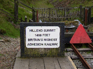
1114:== {{int:filedesc}} == {{Information |description={{en|1=Hillend Summit, Glengonnar Station. The Wanlockhead end of the Leadhills and Wanlockhead Light Railway, terminating at Hillend Summit. At 1498 feet ASL, the highest adhesion railway in Britain.
351:– You must give appropriate credit, provide a link to the license, and indicate if changes were made. You may do so in any reasonable manner, but not in any way that suggests the licensor endorses you or your use.
78:
46:
223:
121:
Hillend Summit, Glengonnar
Station. The Wanlockhead end of the Leadhills and Wanlockhead Light Railway, terminating at Hillend Summit. At 1498 feet ASL, the highest adhesion railway in Britain.
997:
625:
581:
537:
633:
641:
434:
989:
944:
899:
854:
816:
778:
629:
621:
533:
442:
438:
430:
993:
740:
645:
637:
577:
426:
649:
446:
1107:
584:"}},"text\/plain":{"en":{"P275":"Creative Commons Attribution-ShareAlike 2.0 Generic"}}}}": -->
449:"}},"text\/plain":{"en":{"P2699":"https:\/\/www.geograph.org.uk\/profile\/515"}}}}": -->
1096:
1091:
652:"}},"text\/plain":{"en":{"P973":"https:\/\/www.geograph.org.uk\/photo\/12660"}}}}": -->
37:
1041:
675:
607:
563:
233:
710:
268:
1139:
This file contains additional information, probably added from the digital camera or scanner used to create or digitize it.
358:
490:
1007:
958:
913:
868:
826:
788:
688:
659:
547:
511:
498:
483:
1034:
750:
718:
703:
591:
456:
415:
123:
Wanlockhead is
Scotland's highest village, lying on the border between Dumfries & Galloway and South Lanarkshire.
314:
1142:
If the file has been modified from its original state, some details may not fully reflect the modified file.
357:– If you remix, transform, or build upon the material, you must distribute your contributions under the
275:
on the
Geograph website for the photographer's contact details. The copyright on this image is owned by
861:"}},"text\/plain":{"en":{"P3575":"69,486 byte"}}}}": -->
540:"}},"text\/plain":{"en":{"P6216":"copyrighted"}}}}": -->
951:"}},"text\/plain":{"en":{"P2049":"298 pixel"}}}}": -->
906:"}},"text\/plain":{"en":{"P2048":"223 pixel"}}}}": -->
86:
186:
1000:"}},"text\/plain":{"en":{"P459":"SHA-1"}}}}": -->
311:
170:
725:
695:
518:
8:
255:
239:
280:
73:
405:
159:
149:
1017:
968:
923:
878:
836:
798:
760:
669:
601:
557:
466:
260:
1128:
126:
272:
1064:
Click on a date/time to view the file as it appeared at that time.
225:
111:
Hillend Summit, Glengonnar
Station - geograph.org.uk - 12660.jpg
47:
Hillend_Summit,_Glengonnar_Station_-_geograph.org.uk_-_12660.jpg
218:
55° 24′ 08″ N, 3° 46′ 08″ W
61:
399:
Add a one-line explanation of what this file represents
1122:
1062:
85:
Commons is a freely licensed media file repository.
608:
Creative
Commons Attribution-ShareAlike 2.0 Generic
582:
Creative
Commons Attribution-ShareAlike 2.0 Generic
138:
51:(298 × 223 pixels, file size: 68 KB, MIME type:
368:https://creativecommons.org/licenses/by-sa/2.0
66:
374:Creative Commons Attribution-Share Alike 2.0
292:
134:
108:
155:
144:
14:
948:
903:
858:
650:https:\/\/www.geograph.org.uk\/photo\/12660
447:https:\/\/www.geograph.org.uk\/profile\/515
334:– to copy, distribute and transmit the work
1023:c000fccd5cd474ce45029bb89e8388623a68fb2f
726:https://www.geograph.org.uk/photo/12660
519:https://www.geograph.org.uk/profile/515
232:View this and other nearby images on:
193:
97:
279:and is licensed for reuse under the
208:
1124:The following page uses this file:
1055:
315:Attribution-Share Alike 2.0 Generic
303:
298:
283:Attribution-ShareAlike 2.0 license.
13:
1137:
404:
398:
289:
266:
201:Hillend Summit, Glengonnar Station
182:Hillend Summit, Glengonnar Station
127:http://www.leadhillsrailway.co.uk/
115:
98:
44:
1163:
1144:
403:
389:
345:Under the following conditions:
310:This file is licensed under the
302:
297:
291:
259:
238:
224:
65:
21:
386:
116:
41:No higher resolution available.
1059:
676:file available on the internet
626:file available on the internet
385:
267:This image was taken from the
26:
1:
789:coordinates of depicted place
779:coordinates of depicted place
31:
1119:
711:Geograph Britain and Ireland
642:Geograph Britain and Ireland
484:object of statement has role
431:object of statement has role
411:Items portrayed in this file
251:
7:
1134:
10:
1168:
359:same or compatible license
129:for more about the railway
105:
100:
1056:
16:
689:geograph.org.uk image ID
630:geograph.org.uk image ID
388:
325:
72:This is a file from the
36:
1113:
804:55°24'7.9"N, 3°46'8.4"W
171:required by the license
137:
76:. Information from its
1092:03:16, 30 January 2010
273:this photograph's page
244:55.402200; -3.769000
199:Beth Loft /
180:Beth Loft /
79:description page there
1035:determination method
994:determination method
340:– to adapt the work
499:author name string
439:author name string
1155:
1154:
1117:
950:
905:
860:
592:copyright license
578:copyright license
397:
288:
287:
271:collection. See
249:
248:
206:
205:
174:
94:
93:
74:Wikimedia Commons
1159:
1145:
1104:
1066:
1044:
1039:
977:
932:
887:
728:
723:
719:described at URL
713:
708:
698:
693:
646:described at URL
548:copyright status
534:copyright status
521:
516:
506:
503:
493:
488:
395:
381:
378:
375:
372:
369:
361:as the original.
323:
312:Creative Commons
306:
305:
301:
300:
295:
294:
281:Creative Commons
269:Geograph project
263:
256:
245:
242:
228:
227:
221:
220:
209:
168:
140:
120:
112:
106:
90:
69:
68:
62:
56:
54:
1167:
1166:
1162:
1161:
1160:
1158:
1157:
1156:
1133:
1118:
1110:
1102:
1058:
1057:
1054:
1053:
1052:
1051:
1050:
1049:
1048:
1047:
1046:
1045:
1040:
1037:
1028:
1027:
1026:
1024:
1014:
1013:
1012:
1010:
987:
986:
985:
984:
983:
982:
981:
980:
978:
975:
965:
964:
963:
961:
942:
941:
940:
939:
938:
937:
936:
935:
933:
930:
920:
919:
918:
916:
897:
896:
895:
894:
893:
892:
891:
890:
888:
885:
875:
874:
873:
871:
852:
851:
850:
849:
848:
847:
846:
845:
843:
833:
832:
831:
829:
814:
813:
812:
811:
810:
809:
808:
807:
805:
795:
794:
793:
791:
776:
775:
774:
773:
772:
771:
770:
769:
767:
757:
756:
755:
753:
738:
737:
736:
735:
734:
733:
732:
731:
730:
729:
724:
721:
715:
714:
709:
706:
700:
699:
694:
691:
682:
681:
680:
678:
666:
665:
664:
662:
619:
618:
617:
616:
615:
614:
613:
612:
610:
598:
597:
596:
594:
575:
574:
573:
572:
571:
570:
569:
568:
566:
554:
553:
552:
550:
531:
530:
529:
528:
527:
526:
525:
524:
523:
522:
517:
514:
508:
507:
504:
501:
495:
494:
489:
486:
477:
476:
475:
473:
463:
462:
461:
459:
424:
423:
422:
421:
420:
418:
402:
401:
400:
383:
382:
379:
376:
373:
370:
367:
366:
324:
321:
318:
307:
284:
254:
243:
216:
215:
212:Object location
207:
196:
189:
177:
150:geograph.org.uk
130:
110:
103:
96:
95:
84:
83:
82:is shown below.
58:
52:
50:
43:
42:
12:
11:
5:
1165:
1153:
1152:
1149:
1136:
1132:
1131:
1121:
1116:
1115:
1112:
1108:
1105:
1099:
1094:
1089:
1085:
1084:
1081:
1078:
1075:
1072:
1069:
1061:
1033:
1032:
1031:
1030:
1029:
1025:
1022:
1020:
1019:
1018:
1016:
1015:
1011:
1006:
1004:
1003:
1002:
1001:
999:
995:
991:
979:
973:
971:
970:
969:
967:
966:
962:
957:
955:
954:
953:
952:
946:
934:
928:
926:
925:
924:
922:
921:
917:
912:
910:
909:
908:
907:
901:
889:
883:
881:
880:
879:
877:
876:
872:
867:
865:
864:
863:
862:
856:
844:
841:
839:
838:
837:
835:
834:
830:
825:
823:
822:
821:
820:
818:
806:
803:
801:
800:
799:
797:
796:
792:
787:
785:
784:
783:
782:
780:
768:
765:
763:
762:
761:
759:
758:
754:
749:
747:
746:
745:
744:
742:
717:
716:
702:
701:
687:
686:
685:
684:
683:
679:
674:
672:
671:
670:
668:
667:
663:
660:source of file
658:
656:
655:
654:
653:
651:
647:
643:
639:
635:
631:
627:
623:
622:source of file
611:
606:
604:
603:
602:
600:
599:
595:
590:
588:
587:
586:
585:
583:
579:
567:
562:
560:
559:
558:
556:
555:
551:
546:
544:
543:
542:
541:
539:
535:
510:
509:
497:
496:
482:
481:
480:
479:
478:
474:
471:
469:
468:
467:
465:
464:
460:
455:
453:
452:
451:
450:
448:
444:
440:
436:
432:
428:
419:
414:
412:
409:
408:
407:
406:
394:
393:
390:
387:
365:
364:
363:
362:
352:
343:
342:
341:
335:
328:You are free:
319:
309:
308:
290:
286:
285:
264:
253:
250:
247:
246:
236:
230:
213:
204:
203:
197:
194:
191:
190:
185:
178:
175:
163:
162:
157:
153:
152:
146:
142:
141:
136:
132:
131:
113:
104:
102:
99:
92:
91:
70:
60:
59:
40:
35:
34:
29:
24:
19:
9:
6:
4:
3:
2:
1164:
1150:
1147:
1146:
1143:
1140:
1130:
1127:
1126:
1125:
1111:
1106:
1100:
1098:
1095:
1093:
1090:
1087:
1086:
1082:
1079:
1076:
1073:
1070:
1068:
1067:
1065:
1043:
1036:
1021:
1009:
1005:
972:
960:
956:
927:
915:
911:
882:
870:
866:
840:
828:
824:
802:
790:
786:
764:
752:
748:
727:
720:
712:
705:
697:
690:
677:
673:
661:
657:
609:
605:
593:
589:
565:
561:
549:
545:
520:
513:
500:
492:
485:
470:
458:
454:
417:
413:
410:
391:
384:
371:CC BY-SA 2.0
360:
356:
353:
350:
347:
346:
344:
339:
336:
333:
330:
329:
327:
326:
320:Attribution:
316:
313:
296:
282:
278:
274:
270:
265:
262:
258:
257:
241:
237:
235:
234:OpenStreetMap
231:
229:
219:
214:
211:
210:
202:
198:
192:
188:
184: /
183:
179:
172:
167:
165:
164:
161:
158:
154:
151:
147:
143:
133:
128:
124:
119:
114:
107:
88:
81:
80:
75:
71:
64:
63:
57:
48:
39:
33:
30:
28:
25:
23:
20:
18:
15:
1141:
1138:
1123:
1063:
1060:File history
491:photographer
435:photographer
354:
348:
337:
331:
276:
200:
187:CC BY-SA 2.0
181:
122:
117:
87:You can help
77:
45:
22:File history
1109:GeographBot
564:copyrighted
538:copyrighted
355:share alike
349:attribution
166:Attribution
109:Description
1148:_error
1120:File usage
1101:298 × 223
1077:Dimensions
842:image/jpeg
827:media type
817:media type
472:some value
53:image/jpeg
27:File usage
1129:Leadhills
1074:Thumbnail
1071:Date/Time
869:data size
855:data size
751:inception
741:inception
505:Beth Loft
322:Beth Loft
277:Beth Loft
252:Licensing
195:InfoField
176:InfoField
160:Beth Loft
118:English:
1135:Metadata
1008:checksum
990:checksum
704:operator
638:operator
392:Captions
338:to remix
332:to share
317:license.
32:Metadata
1103:(68 KB)
1088:current
1083:Comment
884:69,486
457:creator
427:creator
416:depicts
396:English
101:Summary
49:
914:height
900:height
222:
156:Author
145:Source
1042:SHA-1
998:SHA-1
976:pixel
959:width
949:pixel
945:width
931:pixel
904:pixel
696:12660
634:12660
148:From
1080:User
974:298
929:223
886:byte
859:byte
766:2003
380:true
377:true
139:2003
135:Date
125:See
17:File
512:URL
443:URL
1038::
722::
707::
692::
515::
502::
487::
1151:0
173:)
169:(
89:.
55:)
_&language=en)
