829:"}},"text\/plain":{"en":{"":"coordinates of the point of view"}}},"{\"value\":{\"latitude\":51.175233,\"longitude\":-1.836447,\"altitude\":null,\"precision\":1.0e-6,\"globe\":\"http:\\\/\\\/www.wikidata.org\\\/entity\\\/Q2\"},\"type\":\"globecoordinate\"}":{"text\/html":{"en":{"P1259":"51\u00b010'30.839"N, 1\u00b050'11.209"W"}},"text\/plain":{"en":{"P1259":"51\u00b010'30.839\"N, 1\u00b050'11.209\"W"}}},"{\"value\":{\"entity-type\":\"property\",\"numeric-id\":7787,\"id\":\"P7787\"},\"type\":\"wikibase-entityid\"}":{"text\/html":{"en":{"":"
489:"}},"text\/plain":{"en":{"":"author name string"}}},"{\"value\":\"David Smith\",\"type\":\"string\"}":{"text\/html":{"en":{"P2093":"David Smith"}},"text\/plain":{"en":{"P2093":"David Smith"}}},"{\"value\":{\"entity-type\":\"property\",\"numeric-id\":2699,\"id\":\"P2699\"},\"type\":\"wikibase-entityid\"}":{"text\/html":{"en":{"":"
43:
791:"}},"text\/plain":{"en":{"":"inception"}}},"{\"value\":{\"time\":\"+2014-08-10T00:00:00Z\",\"timezone\":0,\"before\":0,\"after\":0,\"precision\":11,\"calendarmodel\":\"http:\\\/\\\/www.wikidata.org\\\/entity\\\/Q1985727\"},\"type\":\"time\"}":{"text\/html":{"en":{"P571":"10 August 2014"}},"text\/plain":{"en":{"P571":"10 August 2014"}}}}": -->
668:
274:
825:
288:
309:
347:
352:
99:
676:"}},"text\/plain":{"en":{"P7482":"file available on the internet"}}},"{\"value\":{\"entity-type\":\"property\",\"numeric-id\":137,\"id\":\"P137\"},\"type\":\"wikibase-entityid\"}":{"text\/html":{"en":{"":"
684:"}},"text\/plain":{"en":{"P137":"Geograph Britain and Ireland"}}},"{\"value\":{\"entity-type\":\"property\",\"numeric-id\":7384,\"id\":\"P7384\"},\"type\":\"wikibase-entityid\"}":{"text\/html":{"en":{"":"
481:"}},"text\/plain":{"en":{"":"object of statement has role"}}},"{\"value\":{\"entity-type\":\"item\",\"numeric-id\":33231,\"id\":\"Q33231\"},\"type\":\"wikibase-entityid\"}":{"text\/html":{"en":{"P3831":"
628:"}},"text\/plain":{"en":{"":"copyright license"}}},"{\"value\":{\"entity-type\":\"item\",\"numeric-id\":19068220,\"id\":\"Q19068220\"},\"type\":\"wikibase-entityid\"}":{"text\/html":{"en":{"P275":"
584:"}},"text\/plain":{"en":{"":"copyright status"}}},"{\"value\":{\"entity-type\":\"item\",\"numeric-id\":50423863,\"id\":\"Q50423863\"},\"type\":\"wikibase-entityid\"}":{"text\/html":{"en":{"P6216":"
672:"}},"text\/plain":{"en":{"":"source of file"}}},"{\"value\":{\"entity-type\":\"item\",\"numeric-id\":74228490,\"id\":\"Q74228490\"},\"type\":\"wikibase-entityid\"}":{"text\/html":{"en":{"P7482":"
897:"}},"text\/plain":{"en":{"":"captured with"}}},"{\"value\":{\"entity-type\":\"item\",\"numeric-id\":30635137,\"id\":\"Q30635137\"},\"type\":\"wikibase-entityid\"}":{"text\/html":{"en":{"P4082":"
485:"}},"text\/plain":{"en":{"P3831":"photographer"}}},"{\"value\":{\"entity-type\":\"property\",\"numeric-id\":2093,\"id\":\"P2093\"},\"type\":\"wikibase-entityid\"}":{"text\/html":{"en":{"":"
833:"}},"text\/plain":{"en":{"":"heading"}}},"{\"value\":{\"amount\":\"+180\",\"unit\":\"http:\\\/\\\/www.wikidata.org\\\/entity\\\/Q28390\"},\"type\":\"quantity\"}":{"text\/html":{"en":{"P7787":"180
680:"}},"text\/plain":{"en":{"":"operator"}}},"{\"value\":{\"entity-type\":\"item\",\"numeric-id\":1503119,\"id\":\"Q1503119\"},\"type\":\"wikibase-entityid\"}":{"text\/html":{"en":{"P137":"
692:"}},"text\/plain":{"en":{"P7384":"4119376"}}},"{\"value\":{\"entity-type\":\"property\",\"numeric-id\":973,\"id\":\"P973\"},\"type\":\"wikibase-entityid\"}":{"text\/html":{"en":{"":"
477:"}},"text\/plain":{"en":{"":"creator"}}},"{\"value\":{\"entity-type\":\"property\",\"numeric-id\":3831,\"id\":\"P3831\"},\"type\":\"wikibase-entityid\"}":{"text\/html":{"en":{"":"
893:
696:"}},"text\/plain":{"en":{"":"described at URL"}}},"{\"value\":\"https:\\\/\\\/www.geograph.org.uk\\\/photo\\\/4119376\",\"type\":\"string\"}":{"text\/html":{"en":{"P973":"
493:"}},"text\/plain":{"en":{"":"URL"}}},"{\"value\":\"https:\\\/\\\/www.geograph.org.uk\\\/profile\\\/708\",\"type\":\"string\"}":{"text\/html":{"en":{"P2699":"
688:"}},"text\/plain":{"en":{"":"geograph.org.uk image ID"}}},"{\"value\":\"4119376\",\"type\":\"string\"}":{"text\/html":{"en":{"P7384":"
257:
399:– You must give appropriate credit, provide a link to the license, and indicate if changes were made. You may do so in any reasonable manner, but not in any way that suggests the licensor endorses you or your use.
271:
689:
898:
673:
629:
585:
681:
65:
61:
57:
53:
47:
482:
110:
894:
830:
826:
685:
669:
581:
490:
486:
478:
78:
697:
788:
693:
677:
625:
474:
494:
996:== {{int:filedesc}} == {{Information |Description={{en|1=Normanton Down}} |Source=From |Date=2014-08-10 |Author= |Permission=Creative Commons...
632:"}},"text\/plain":{"en":{"P275":"Creative Commons Attribution-ShareAlike 2.0 Generic"}}}}": -->
194:
700:"}},"text\/plain":{"en":{"P973":"https:\/\/www.geograph.org.uk\/photo\/4119376"}}}}": -->
1187:
497:"}},"text\/plain":{"en":{"P2699":"https:\/\/www.geograph.org.uk\/profile\/708"}}}}": -->
924:
723:
655:
611:
281:
743:
316:
1081:
This file contains additional information, probably added from the digital camera or scanner used to create or digitize it.
406:
538:
908:
871:
844:
751:
707:
595:
559:
546:
531:
798:
766:
736:
639:
504:
463:
901:"}},"text\/plain":{"en":{"P4082":"Panasonic Lumix DMC-TZ60"}}}}": -->
978:
973:
69:
42:
1218:
362:
1084:
If the file has been modified from its original state, some details may not fully reflect the modified file.
405:– If you remix, transform, or build upon the material, you must distribute your contributions under the
323:
on the
Geograph website for the photographer's contact details. The copyright on this image is owned by
588:"}},"text\/plain":{"en":{"P6216":"copyrighted"}}}}": -->
837:"}},"text\/plain":{"en":{"P7787":"180 degree"}}}}": -->
118:
226:
1010:
1266:
773:
758:
359:
210:
566:
8:
1302:
303:
287:
1415:
328:
105:
453:
1370:
1284:
1110:
989:
173:
1425:
1380:
1150:
918:
854:
808:
717:
649:
605:
514:
183:
1320:
308:
1058:
1130:
320:
1093:
1435:
1120:
1103:
946:
Click on a date/time to view the file as it appeared at that time.
1213:
Landscape mode (for landscape photos with the background in focus)
273:
258:
51° 10′ 30.84″ N, 1° 50′ 11.21″ W
1028:
162:
93:
1048:
1038:
447:
Add a one-line explanation of what this file represents
83:(1,600 × 1,200 pixels, file size: 1.03 MB, MIME type:
1068:
1004:
1019:
944:
201:
Creative
Commons Attribution Share-alike license 2.0
117:
Commons is a freely licensed media file repository.
656:
Creative
Commons Attribution-ShareAlike 2.0 Generic
630:
Creative
Commons Attribution-ShareAlike 2.0 Generic
416:https://creativecommons.org/licenses/by-sa/2.0
143:Normanton Down - geograph.org.uk - 4119376.jpg
98:
698:https:\/\/www.geograph.org.uk\/photo\/4119376
422:Creative Commons Attribution-Share Alike 2.0
340:
189:
158:
140:
179:
168:
14:
834:
495:https:\/\/www.geograph.org.uk\/profile\/708
382:– to copy, distribute and transmit the work
1021:The following other wikis use this file:
774:https://www.geograph.org.uk/photo/4119376
567:https://www.geograph.org.uk/profile/708
280:View this and other nearby images on:
233:
129:
327:and is licensed for reuse under the
248:
1006:The following page uses this file:
937:
363:Attribution-Share Alike 2.0 Generic
351:
346:
331:Attribution-ShareAlike 2.0 license.
13:
1079:
452:
446:
337:
314:
147:
130:
76:
1452:
1086:
451:
1141:Date and time of data generation
845:coordinates of the point of view
827:coordinates of the point of view
437:
393:Under the following conditions:
358:This file is licensed under the
350:
345:
339:
307:
286:
272:
264:
97:
31:
21:
434:
148:
1016:
941:
724:file available on the internet
674:file available on the internet
433:
315:This image was taken from the
26:
1:
1349:A directly photographed image
1307:Flash did not fire, auto mode
860:51°10'30.839"N, 1°50'11.209"W
36:
1001:
744:Geograph Britain and Ireland
682:Geograph Britain and Ireland
532:object of statement has role
479:object of statement has role
459:Items portrayed in this file
299:
263:
7:
1229:Date and time of digitizing
1076:
1059:Normanton Down Barrow Group
1045:Usage on fr.wikivoyage.org
1035:Usage on en.wikivoyage.org
10:
1457:
1391:Focal length in 35 mm film
1333:One-chip color area sensor
1312:Supported Flashpix version
1065:Usage on www.wikidata.org
1055:Usage on nl.wikipedia.org
1025:Usage on de.wikipedia.org
407:same or compatible license
137:
132:
1237:Meaning of each component
1194:File change date and time
938:
16:
925:Panasonic Lumix DMC-TZ60
899:Panasonic Lumix DMC-TZ60
752:geograph.org.uk image ID
686:geograph.org.uk image ID
436:
373:
239:David Smith /
220:David Smith /
104:This is a file from the
41:
1354:Custom image processing
995:
211:required by the license
161:
108:. Information from its
1279:4.2734375 APEX (f/4.4)
1258:Image compression mode
1011:Normanton Down Barrows
321:this photograph's page
292:51.175233; -1.836447
111:description page there
46:Size of this preview:
1276:Maximum land aperture
1232:13:33, 10 August 2014
1197:13:33, 10 August 2014
1168:Horizontal resolution
1144:13:33, 10 August 2014
974:17:59, 17 August 2014
1341:Digital still camera
70:1,600 × 1,200 pixels
1202:Y and C positioning
1176:Vertical resolution
1090:Camera manufacturer
388:– to adapt the work
52:Other resolutions:
1399:Scene capture type
1375:Auto white balance
547:author name string
487:author name string
66:1,280 × 960 pixels
62:1,024 × 768 pixels
1444:
1443:
1115:1/250 sec (0.004)
1017:Global file usage
999:
836:
640:copyright license
626:copyright license
445:
336:
335:
319:collection. See
297:
296:
246:
245:
214:
198:
195:Reusing this file
126:
125:
106:Wikimedia Commons
32:Global file usage
1448:
1210:Exposure Program
1087:
986:
948:
882:
881:
876:
776:
771:
767:described at URL
761:
756:
746:
741:
694:described at URL
596:copyright status
582:copyright status
569:
564:
554:
551:
541:
536:
443:
429:
426:
423:
420:
417:
409:as the original.
371:
360:Creative Commons
354:
353:
349:
348:
343:
342:
329:Creative Commons
317:Geograph project
311:
304:
293:
290:
276:
275:
269:
268:
267:
261:
260:
249:
208:
192:
164:
152:
144:
138:
122:
101:
100:
94:
88:
86:
73:
58:640 × 480 pixels
54:320 × 240 pixels
48:800 × 600 pixels
1456:
1455:
1451:
1450:
1449:
1447:
1446:
1445:
1075:
1015:
1000:
992:
984:
940:
939:
936:
935:
934:
933:
932:
931:
930:
929:
927:
915:
914:
913:
911:
892:
891:
890:
889:
888:
887:
886:
885:
884:
883:
879:
877:
874:
865:
864:
863:
861:
851:
850:
849:
847:
824:
823:
822:
821:
820:
819:
818:
817:
815:
805:
804:
803:
801:
786:
785:
784:
783:
782:
781:
780:
779:
778:
777:
772:
769:
763:
762:
757:
754:
748:
747:
742:
739:
730:
729:
728:
726:
714:
713:
712:
710:
667:
666:
665:
664:
663:
662:
661:
660:
658:
646:
645:
644:
642:
623:
622:
621:
620:
619:
618:
617:
616:
614:
602:
601:
600:
598:
579:
578:
577:
576:
575:
574:
573:
572:
571:
570:
565:
562:
556:
555:
552:
549:
543:
542:
537:
534:
525:
524:
523:
521:
511:
510:
509:
507:
472:
471:
470:
469:
468:
466:
450:
449:
448:
431:
430:
427:
424:
421:
418:
415:
414:
372:
369:
366:
355:
332:
302:
291:
265:
256:
255:
252:Camera location
247:
236:
229:
217:
174:geograph.org.uk
154:
142:
135:
128:
127:
116:
115:
114:is shown below.
90:
84:
82:
75:
74:
51:
12:
11:
5:
1454:
1442:
1441:
1438:
1432:
1431:
1428:
1422:
1421:
1418:
1412:
1411:
1408:
1404:
1403:
1400:
1396:
1395:
1392:
1388:
1387:
1384:
1377:
1376:
1373:
1367:
1366:
1363:
1359:
1358:
1357:Normal process
1355:
1351:
1350:
1347:
1343:
1342:
1339:
1335:
1334:
1331:
1330:Sensing method
1327:
1326:
1323:
1317:
1316:
1313:
1309:
1308:
1305:
1299:
1298:
1295:
1291:
1290:
1287:
1281:
1280:
1277:
1273:
1272:
1269:
1263:
1262:
1259:
1255:
1254:
1253:
1252:
1251:does not exist
1249:
1246:
1243:
1238:
1234:
1233:
1230:
1226:
1225:
1222:
1215:
1214:
1211:
1207:
1206:
1203:
1199:
1198:
1195:
1191:
1190:
1185:
1181:
1180:
1177:
1173:
1172:
1169:
1165:
1164:
1161:
1157:
1156:
1153:
1146:
1145:
1142:
1138:
1137:
1134:
1127:
1126:
1123:
1117:
1116:
1113:
1107:
1106:
1101:
1097:
1096:
1091:
1078:
1074:
1073:
1072:
1071:
1063:
1062:
1061:
1053:
1052:
1051:
1043:
1042:
1041:
1033:
1032:
1031:
1029:Normanton Down
1018:
1014:
1013:
1003:
998:
997:
994:
990:
987:
983:1,600 × 1,200
981:
976:
971:
967:
966:
963:
960:
957:
954:
951:
943:
928:
923:
921:
920:
919:
917:
916:
912:
907:
905:
904:
903:
902:
900:
896:
870:
869:
868:
867:
866:
862:
859:
857:
856:
855:
853:
852:
848:
843:
841:
840:
839:
838:
832:
828:
816:
814:10 August 2014
813:
811:
810:
809:
807:
806:
802:
797:
795:
794:
793:
792:
790:
765:
764:
750:
749:
735:
734:
733:
732:
731:
727:
722:
720:
719:
718:
716:
715:
711:
708:source of file
706:
704:
703:
702:
701:
699:
695:
691:
687:
683:
679:
675:
671:
670:source of file
659:
654:
652:
651:
650:
648:
647:
643:
638:
636:
635:
634:
633:
631:
627:
615:
610:
608:
607:
606:
604:
603:
599:
594:
592:
591:
590:
589:
587:
583:
558:
557:
545:
544:
530:
529:
528:
527:
526:
522:
519:
517:
516:
515:
513:
512:
508:
503:
501:
500:
499:
498:
496:
492:
488:
484:
480:
476:
467:
462:
460:
457:
456:
455:
454:
442:
441:
438:
435:
413:
412:
411:
410:
400:
391:
390:
389:
383:
376:You are free:
367:
357:
356:
338:
334:
333:
312:
301:
298:
295:
294:
284:
278:
253:
244:
243:
241:Normanton Down
237:
234:
231:
230:
225:
222:Normanton Down
218:
215:
203:
202:
199:
187:
186:
181:
177:
176:
170:
166:
165:
163:10 August 2014
160:
156:
155:
153:Normanton Down
145:
136:
134:
131:
124:
123:
102:
92:
91:
45:
40:
39:
34:
29:
24:
19:
9:
6:
4:
3:
2:
1453:
1439:
1437:
1434:
1433:
1429:
1427:
1424:
1423:
1419:
1417:
1414:
1413:
1409:
1407:Scene control
1406:
1405:
1401:
1398:
1397:
1393:
1390:
1389:
1385:
1382:
1379:
1378:
1374:
1372:
1371:White balance
1369:
1368:
1365:Auto exposure
1364:
1362:Exposure mode
1361:
1360:
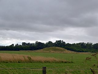
1356:
1353:
1352:
1348:
1345:
1344:
1340:
1337:
1336:
1332:
1329:
1328:
1324:
1322:
1319:
1318:
1314:
1311:
1310:
1306:
1304:
1301:
1300:
1296:
1293:
1292:
1288:
1286:
1285:Metering mode
1283:
1282:
1278:
1275:
1274:
1270:
1268:
1267:Exposure bias
1265:
1264:
1260:
1257:
1256:
1250:
1247:
1244:
1241:
1240:
1239:
1236:
1235:
1231:
1228:
1227:
1223:
1220:
1217:
1216:
1212:
1209:
1208:
1204:
1201:
1200:
1196:
1193:
1192:
1189:
1186:
1184:Software used
1183:
1182:
1178:
1175:
1174:
1170:
1167:
1166:
1162:
1159:
1158:
1154:
1152:
1148:
1147:
1143:
1140:
1139:
1135:
1132:
1129:
1128:
1124:
1122:
1119:
1118:
1114:
1112:
1111:Exposure time
1109:
1108:
1105:
1102:
1099:
1098:
1095:
1092:
1089:
1088:
1085:
1082:
1070:
1067:
1066:
1064:
1060:
1057:
1056:
1054:
1050:
1047:
1046:
1044:
1040:
1037:
1036:
1034:
1030:
1027:
1026:
1024:
1023:
1022:
1012:
1009:
1008:
1007:
993:
988:
982:
980:
977:
975:
972:
969:
968:
964:
961:
958:
955:
952:
950:
949:
947:
926:
922:
910:
909:captured with
906:
895:captured with
873:
858:
846:
842:
812:
800:
796:
775:
768:
760:
753:
745:
738:
725:
721:
709:
705:
657:
653:
641:
637:
613:
609:
597:
593:
568:
561:
548:
540:
533:
518:
506:
502:
465:
461:
458:
439:
432:
419:CC BY-SA 2.0
408:
404:
401:
398:
395:
394:
392:
387:
384:
381:
378:
377:
375:
374:
368:Attribution:
364:
361:
344:
330:
326:
322:
318:
313:
310:
306:
305:
289:
285:
283:
282:OpenStreetMap
279:
277:
259:
254:
251:
250:
242:
238:
232:
228:
224: /
223:
219:
212:
207:
205:
204:
200:
196:
191:
188:
185:
182:
178:
175:
171:
167:
157:
151:
146:
139:
120:
113:
112:
107:
103:
96:
95:
89:
80:
79:Original file
71:
67:
63:
59:
55:
49:
44:
38:
35:
33:
30:
28:
25:
23:
20:
18:
15:
1381:Digital zoom
1294:Light source
1151:focal length
1100:Camera model
1083:
1080:
1020:
1005:
945:
942:File history
539:photographer
483:photographer
402:
396:
385:
379:
324:
262:
240:
227:CC BY-SA 2.0
221:
149:
119:You can help
109:
77:
22:File history
1410:Low gain up
1338:File source
1321:Color space
1160:Orientation
612:copyrighted
586:copyrighted
553:David Smith
403:share alike
397:attribution
370:David Smith
325:David Smith
206:Attribution
184:David Smith
141:Description
1426:Saturation
1346:Scene type
1049:Stonehenge
1039:Stonehenge
1002:File usage
959:Dimensions
520:some value
190:Permission
85:image/jpeg
27:File usage
1436:Sharpness
1188:Ver.1.0
1131:ISO speed
1094:Panasonic
985:(1.03 MB)
956:Thumbnail
953:Date/Time
799:inception
789:inception
300:Licensing
235:InfoField
216:InfoField
150:English:
1416:Contrast
1402:Standard
1205:Co-sited
1121:F-number
1104:DMC-TZ60
1077:Metadata
1069:Q1999806
991:Pasicles
737:operator
678:operator
440:Captions
386:to remix
380:to share
365:license.
37:Metadata
1297:Unknown
1289:Pattern
1221:version
1179:180 dpi
1171:180 dpi
1155:11.7 mm
970:current
965:Comment
872:heading
831:heading
759:4119376
690:4119376
505:creator
475:creator
464:depicts
444:English
133:Summary
81:
1440:Normal
1430:Normal
1420:Normal
1163:Normal
1133:rating
880:degree
835:degree
270:
180:Author
169:Source
1394:69 mm
1383:ratio
1303:Flash
1149:Lens
1125:f/4.4
172:From
1325:sRGB
1219:Exif
962:User
878:180
428:true
425:true
159:Date
17:File
1224:2.3
1136:160
560:URL
491:URL
1248:Cr
1245:Cb
875::
770::
755::
740::
563::
550::
535::
68:|
64:|
60:|
56:|
50:.
1386:0
1315:1
1271:0
1261:4
1242:Y
213:)
209:(
197:)
193:(
121:.
87:)
72:.
Text is available under the Creative Commons Attribution-ShareAlike License. Additional terms may apply.

