232:
280:
268:
184:
220:
559:
352:
316:
244:
340:
328:
376:
139:
256:
148:
476:
452:
440:
304:
160:
292:
172:
364:
395:
512:
488:
404:
464:
208:
565:
416:
38:
428:
196:
86:
762:"}},"text\/plain":{"en":{"P275":"Creative Commons Attribution-ShareAlike 3.0 Unported"}}},"{\"value\":{\"entity-type\":\"item\",\"numeric-id\":50829104,\"id\":\"Q50829104\"},\"type\":\"wikibase-entityid\"}":{"text\/html":{"en":{"P275":"
570:
758:"}},"text\/plain":{"en":{"":"copyright license"}}},"{\"value\":{\"entity-type\":\"item\",\"numeric-id\":14946043,\"id\":\"Q14946043\"},\"type\":\"wikibase-entityid\"}":{"text\/html":{"en":{"P275":"
714:"}},"text\/plain":{"en":{"":"copyright status"}}},"{\"value\":{\"entity-type\":\"item\",\"numeric-id\":50423863,\"id\":\"Q50423863\"},\"type\":\"wikibase-entityid\"}":{"text\/html":{"en":{"P6216":"
710:
861:
1028:
618:– You must give appropriate credit, provide a link to the license, and indicate if changes were made. You may do so in any reasonable manner, but not in any way that suggests the licensor endorses you or your use.
1283:
1303:
763:
759:
715:
1023:
711:
755:
1323:
1198:
909:
529:
231:
1203:
1083:
1273:
766:"}},"text\/plain":{"en":{"P275":"GNU Free Documentation License, version 1.2 or later"}}}}": -->
908:
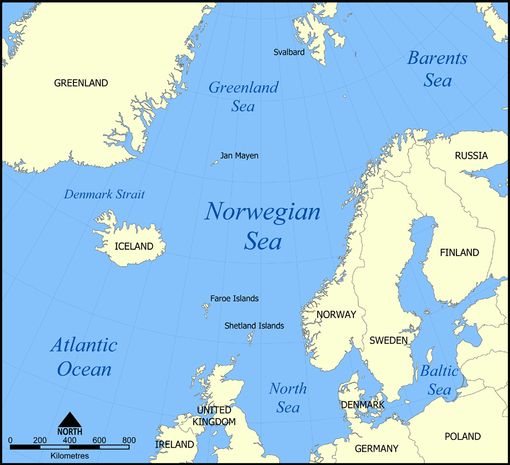
A map showing the location of the
Norwegian Sea in the North Atlantic Ocean. Created by NormanEinstein, August 25, 2005. {{GFDL-self}}
1268:
1008:
527:; with no Invariant Sections, no Front-Cover Texts, and no Back-Cover Texts. A copy of the license is included in the section entitled
1422:
806:
789:
741:
625:
119:
A map showing the location of the
Norwegian Sea in the North Atlantic Ocean. Created by NormanEinstein, August 25, 2005.
52:
48:
42:
725:
1363:
1048:
519:
97:
1013:
773:
700:
65:
960:
1108:
890:
885:
579:
524:
970:
965:
279:
624:– If you remix, transform, or build upon the material, you must distribute your contributions under the
267:
1073:
1068:
718:"}},"text\/plain":{"en":{"P6216":"copyrighted"}}}}": -->
219:
183:
1103:
1188:
925:
105:
639:
517:
Permission is granted to copy, distribute and/or modify this document under the terms of the
351:
315:
1218:
576:
1223:
1213:
255:
243:
8:
935:
901:
871:
339:
327:
303:
159:
487:
463:
439:
147:
860:
855:
475:
403:
375:
291:
171:
56:
37:
451:
207:
503:
I, the copyright holder of this work, hereby publish it under the following licenses:
92:
690:
415:
363:
945:
955:
950:
940:
427:
1168:
195:
138:
930:
1233:
1128:
394:
1393:
1178:
800:
783:
735:
1378:
506:
1258:
828:
Click on a date/time to view the file as it appeared at that time.
1353:
1253:
988:
1138:
1118:
998:
1403:
1343:
638:
This licensing tag was added to this file as part of the GFDL
1058:
1388:
1338:
1413:
1373:
1158:
1333:
1293:
1243:
1038:
1313:
80:
684:
Add a one-line explanation of what this file represents
1148:
919:
979:
826:
807:
790:
Creative
Commons Attribution-ShareAlike 3.0 Unported
764:
760:
Creative
Commons Attribution-ShareAlike 3.0 Unported
523:, Version 1.2 or any later version published by the
104:
Commons is a freely licensed media file repository.
1093:
70:(1,000 × 913 pixels, file size: 513 KB, MIME type:
645:http://creativecommons.org/licenses/by-sa/3.0/
85:
558:
651:Creative Commons Attribution-Share Alike 3.0
14:
601:– to copy, distribute and transmit the work
665:You may select the license of your choice.
981:The following other wikis use this file:
921:The following 10 pages use this file:
1074:Portál:Geografie/Článek týdne/2009/32
116:
1069:Portál:Geografie/Článek týdne/Archiv
580:Attribution-Share Alike 3.0 Unported
553:
535:http://www.gnu.org/copyleft/fdl.html
819:
569:
564:
13:
689:
683:
664:
502:
117:
63:
1434:
1165:Usage on incubator.wikimedia.org
688:
237:français (Jan Mayen localisation)
122:
674:
612:Under the following conditions:
575:This file is licensed under the
568:
563:
557:
511:
510:
486:
474:
462:
450:
438:
426:
414:
402:
393:
374:
362:
350:
338:
326:
314:
302:
290:
278:
266:
254:
242:
230:
218:
206:
194:
182:
170:
158:
146:
137:
84:
31:
21:
671:
1400:Usage on simple.wikipedia.org
976:
823:
670:
541:GNU Free Documentation License
530:GNU Free Documentation License
520:GNU Free Documentation License
26:
1:
1129:Utilisateur:Skiff/A illustrer
961:Operation Rösselsprung (1942)
1029:বিশ্বের প্রণালীসমূহের তালিকা
916:
696:Items portrayed in this file
7:
1360:Usage on pnb.wikipedia.org
1350:Usage on pms.wikipedia.org
1330:Usage on pl.wiktionary.org
1290:Usage on nds.wikipedia.org
1045:Usage on ckb.wikipedia.org
995:Usage on bew.wikipedia.org
971:User talk:Keith-264/sandbox
966:User:NormanEinstein/gallery
10:
1439:
1410:Usage on sq.wikipedia.org
1385:Usage on ro.wikipedia.org
1370:Usage on pt.wikipedia.org
1320:Usage on pa.wikipedia.org
1310:Usage on nl.wikipedia.org
1300:Usage on ne.wikipedia.org
1280:Usage on mr.wikipedia.org
1265:Usage on mn.wikipedia.org
1250:Usage on lt.wikipedia.org
1240:Usage on la.wikipedia.org
1230:Usage on ku.wikipedia.org
1210:Usage on ko.wikipedia.org
1195:Usage on ka.wikipedia.org
1185:Usage on ja.wikipedia.org
1175:Usage on is.wikipedia.org
1155:Usage on id.wikipedia.org
1145:Usage on hr.wikipedia.org
1135:Usage on gv.wikipedia.org
1125:Usage on fr.wikipedia.org
1115:Usage on fi.wikipedia.org
1100:Usage on fa.wikipedia.org
1090:Usage on eo.wikipedia.org
1080:Usage on el.wikipedia.org
1065:Usage on cs.wikipedia.org
1055:Usage on co.wikipedia.org
1035:Usage on br.wikipedia.org
1020:Usage on bn.wikipedia.org
1005:Usage on bg.wikipedia.org
985:Usage on af.wikipedia.org
626:same or compatible license
878:Added a few extra labels.
820:
584:
556:
127:
16:
673:
525:Free Software Foundation
91:This is a file from the
36:
926:Action of 16 March 1917
907:
877:
95:. Information from its
1394:Strâmtoarea Danemarcei
1179:Norræna Atlantsnefndin
856:16:10, 7 November 2005
98:description page there
41:Size of this preview:
910:Category:Maps of seas
886:20:40, 25 August 2005
1169:Wp/bew/Laot Norwèhen
989:Straat van Denemarke
1234:Deryaya Grînlendayê
1139:Yn Vooir Loghlynagh
936:Coastline of Norway
607:– to adapt the work
47:Other resolutions:
1379:Mar da Gronelândia
1084:Πορθμός της Δανίας
57:1,000 × 913 pixels
1423:more global usage
1284:नॉर्वेजियन समुद्र
1274:Гренландын тэнгис
1259:Grenlandijos jūra
977:Global file usage
914:
774:copyright license
756:copyright license
682:
662:
661:
552:
551:
113:
112:
93:Wikimedia Commons
32:Global file usage
1430:
1344:mare di Norvegia
1304:डेनमार्क जलसन्धि
1269:Норвегийн тэнгис
1059:Mare di Nurvegia
1009:Гренландско море
946:Northern Barrage
898:
868:
830:
726:copyright status
712:copyright status
680:
658:
655:
652:
649:
646:
643:
640:licensing update
628:as the original.
577:Creative Commons
572:
571:
567:
566:
561:
560:
554:
548:
545:
542:
539:
536:
514:
513:
507:
490:
478:
466:
454:
442:
430:
418:
406:
397:
378:
366:
354:
342:
330:
318:
306:
294:
282:
270:
258:
246:
234:
222:
210:
198:
186:
174:
162:
150:
141:
109:
88:
87:
81:
75:
73:
60:
53:526 × 480 pixels
49:263 × 240 pixels
43:657 × 600 pixels
1438:
1437:
1433:
1432:
1431:
1429:
1428:
1427:
1389:Marea Norvegiei
1354:Mar ëd Norvegia
1254:Norvegijos jūra
1024:নরওয়েজীয় সাগর
975:
956:Ocean fisheries
951:Northern Patrol
915:
904:
896:
874:
866:
822:
821:
818:
817:
816:
815:
814:
813:
812:
811:
809:
798:
797:
796:
795:
794:
792:
780:
779:
778:
776:
753:
752:
751:
750:
749:
748:
747:
746:
744:
732:
731:
730:
728:
709:
708:
707:
706:
705:
703:
687:
686:
685:
668:
667:
666:
656:
653:
650:
647:
644:
637:
546:
543:
540:
537:
534:
505:
504:
494:
491:
482:
479:
470:
467:
458:
455:
446:
443:
434:
431:
422:
419:
410:
407:
398:
382:
379:
370:
367:
358:
355:
346:
343:
334:
331:
322:
319:
310:
307:
298:
295:
286:
283:
274:
271:
262:
259:
250:
247:
238:
235:
226:
223:
214:
211:
202:
199:
190:
187:
178:
175:
166:
163:
154:
151:
142:
125:
115:
114:
103:
102:
101:is shown below.
77:
71:
69:
62:
61:
46:
12:
11:
5:
1436:
1425:of this file.
1419:
1418:
1417:
1416:
1414:Deti Norvegjez
1408:
1407:
1406:
1404:Denmark Strait
1398:
1397:
1396:
1391:
1383:
1382:
1381:
1376:
1374:Mar da Noruega
1368:
1367:
1366:
1358:
1357:
1356:
1348:
1347:
1346:
1341:
1339:mar de Noruega
1336:
1328:
1327:
1326:
1324:ਡੈੱਨਮਾਰਕ ਪਣਜੋੜ
1318:
1317:
1316:
1308:
1307:
1306:
1298:
1297:
1296:
1288:
1287:
1286:
1278:
1277:
1276:
1271:
1263:
1262:
1261:
1256:
1248:
1247:
1246:
1238:
1237:
1236:
1228:
1227:
1226:
1221:
1216:
1208:
1207:
1206:
1201:
1199:ნორვეგიის ზღვა
1193:
1192:
1191:
1183:
1182:
1181:
1173:
1172:
1171:
1163:
1162:
1161:
1159:Laut Greenland
1153:
1152:
1151:
1143:
1142:
1141:
1133:
1132:
1131:
1123:
1122:
1121:
1119:Grönlanninmeri
1113:
1112:
1111:
1106:
1098:
1097:
1096:
1088:
1087:
1086:
1078:
1077:
1076:
1071:
1063:
1062:
1061:
1053:
1052:
1051:
1043:
1042:
1041:
1033:
1032:
1031:
1026:
1018:
1017:
1016:
1011:
1003:
1002:
1001:
993:
992:
991:
978:
974:
973:
968:
963:
958:
953:
948:
943:
941:Denmark Strait
938:
933:
928:
918:
913:
912:
906:
903:NormanEinstein
902:
899:
893:
888:
883:
880:
879:
876:
873:NormanEinstein
872:
869:
863:
858:
853:
849:
848:
845:
842:
839:
836:
833:
825:
810:
805:
803:
802:
801:
799:
793:
788:
786:
785:
784:
782:
781:
777:
772:
770:
769:
768:
767:
765:
761:
757:
745:
740:
738:
737:
736:
734:
733:
729:
724:
722:
721:
720:
719:
717:
713:
704:
699:
697:
694:
693:
692:
691:
679:
678:
675:
672:
663:
660:
659:
634:
633:
632:
631:
630:
629:
619:
610:
609:
608:
602:
595:You are free:
590:
589:
586:
585:
583:
573:
550:
549:
515:
501:
500:
496:
495:
492:
485:
483:
480:
473:
471:
468:
461:
459:
456:
449:
447:
444:
437:
435:
432:
425:
423:
420:
413:
411:
408:
401:
399:
392:
389:
388:
384:
383:
380:
373:
371:
368:
361:
359:
356:
349:
347:
344:
337:
335:
332:
325:
323:
320:
313:
311:
308:
301:
299:
296:
289:
287:
284:
277:
275:
272:
265:
263:
260:
253:
251:
248:
241:
239:
236:
229:
227:
224:
217:
215:
212:
205:
203:
200:
193:
191:
188:
181:
179:
176:
169:
167:
164:
157:
155:
152:
145:
143:
136:
133:
132:
124:
123:Other versions
121:
111:
110:
89:
79:
78:
40:
35:
34:
29:
24:
19:
9:
6:
4:
3:
2:
1435:
1426:
1424:
1415:
1412:
1411:
1409:
1405:
1402:
1401:
1399:
1395:
1392:
1390:
1387:
1386:
1384:
1380:
1377:
1375:
1372:
1371:
1369:
1365:
1364:آبنائے ڈنمارک
1362:
1361:
1359:
1355:
1352:
1351:
1349:
1345:
1342:
1340:
1337:
1335:
1332:
1331:
1329:
1325:
1322:
1321:
1319:
1315:
1312:
1311:
1309:
1305:
1302:
1301:
1299:
1295:
1292:
1291:
1289:
1285:
1282:
1281:
1279:
1275:
1272:
1270:
1267:
1266:
1264:
1260:
1257:
1255:
1252:
1251:
1249:
1245:
1244:Fretum Daniae
1242:
1241:
1239:
1235:
1232:
1231:
1229:
1225:
1222:
1220:
1217:
1215:
1212:
1211:
1209:
1205:
1202:
1200:
1197:
1196:
1194:
1190:
1187:
1186:
1184:
1180:
1177:
1176:
1174:
1170:
1167:
1166:
1164:
1160:
1157:
1156:
1154:
1150:
1147:
1146:
1144:
1140:
1137:
1136:
1134:
1130:
1127:
1126:
1124:
1120:
1117:
1116:
1114:
1110:
1107:
1105:
1102:
1101:
1099:
1095:
1092:
1091:
1089:
1085:
1082:
1081:
1079:
1075:
1072:
1070:
1067:
1066:
1064:
1060:
1057:
1056:
1054:
1050:
1049:دەریای نەرویژ
1047:
1046:
1044:
1040:
1039:Mor Greunland
1037:
1036:
1034:
1030:
1027:
1025:
1022:
1021:
1019:
1015:
1014:Датски проток
1012:
1010:
1007:
1006:
1004:
1000:
999:Laot Norwèhen
997:
996:
994:
990:
987:
986:
984:
983:
982:
972:
969:
967:
964:
962:
959:
957:
954:
952:
949:
947:
944:
942:
939:
937:
934:
932:
929:
927:
924:
923:
922:
911:
905:
900:
894:
892:
889:
887:
884:
882:
881:
875:
870:
864:
862:
859:
857:
854:
851:
850:
846:
843:
840:
837:
834:
832:
831:
829:
808:
804:
791:
787:
775:
771:
743:
739:
727:
723:
702:
698:
695:
676:
669:
641:
636:
635:
627:
623:
620:
617:
614:
613:
611:
606:
603:
600:
597:
596:
594:
593:
592:
591:
588:
587:
581:
578:
574:
562:
555:
532:
531:
526:
522:
521:
516:
509:
508:
499:
498:
489:
484:
477:
472:
465:
460:
453:
448:
441:
436:
429:
424:
417:
412:
405:
400:
396:
391:
390:
386:
385:
377:
372:
365:
360:
353:
348:
341:
336:
329:
324:
317:
312:
305:
300:
293:
288:
281:
276:
269:
264:
257:
252:
245:
240:
233:
228:
221:
216:
209:
204:
197:
192:
185:
180:
173:
168:
161:
156:
149:
144:
140:
135:
134:
131:Norwegian Sea
130:
129:
128:
120:
107:
100:
99:
94:
90:
83:
82:
76:
67:
66:Original file
58:
54:
50:
44:
39:
33:
30:
28:
25:
23:
20:
18:
15:
1420:
1334:Norska havet
1314:Groenlandzee
1294:Noorsche See
1204:დანიის სრუტე
1109:تنگه دانمارک
980:
931:Channel Dash
920:
895:1,000 × 914
865:1,000 × 913
827:
824:File history
648:CC BY-SA 3.0
621:
615:
604:
598:
528:
518:
497:
126:
118:
106:You can help
96:
64:
22:File history
742:copyrighted
716:copyrighted
622:share alike
616:attribution
387:Barents Sea
1104:دریای نروژ
917:File usage
841:Dimensions
357:українська
321:македонски
27:File usage
1149:Jan Mayen
838:Thumbnail
835:Date/Time
582:license.
469:Kiswahili
72:image/png
897:(502 KB)
867:(513 KB)
677:Captions
605:to remix
599:to share
493:Ελληνικά
445:hrvatski
261:italiano
249:hrvatski
225:français
153:bosanski
852:current
847:Comment
701:depicts
681:English
481:русский
433:español
421:English
409:Deutsch
345:русский
333:нохчийн
309:svenska
213:English
189:Deutsch
165:čeština
68:
1219:덴마크 해협
1189:ノルウェー海
1094:Nordio
457:magyar
285:magyar
273:magyar
1421:View
1224:그린란드해
1214:노르웨이해
381:עברית
297:norsk
201:eesti
177:dansk
844:User
657:true
654:true
547:true
544:true
538:GFDL
17:File
369:中文
55:|
51:|
45:.
642:.
533:.
108:.
74:)
59:.
Text is available under the Creative Commons Attribution-ShareAlike License. Additional terms may apply.


