380:
530:"}},"text\/plain":{"en":{"":"inception"}}},"{\"value\":{\"time\":\"+2010-01-11T00:00:00Z\",\"timezone\":0,\"before\":0,\"after\":0,\"precision\":11,\"calendarmodel\":\"http:\\\/\\\/www.wikidata.org\\\/entity\\\/Q1985727\"},\"type\":\"time\"}":{"text\/html":{"en":{"P571":"11 January 2010"}},"text\/plain":{"en":{"P571":"11 January 2010"}}}}": -->
38:
215:
Columbia, Canada through only two states, forming part of the
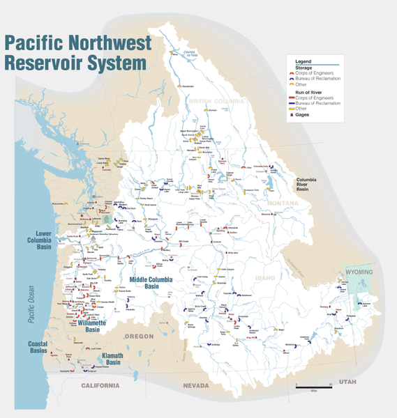
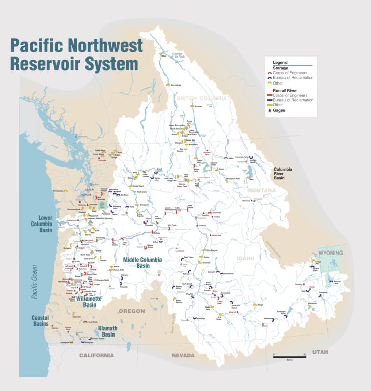
Washington-Oregon border, the vast Interior Columbia River Basin is defined by the area drained by the river and its many tributaries. This 58-million-hectare area (about the size of France) extends roughly from the crest of the Cascade Mountains of Oregon and Washington east through Idaho to the Continental Divide in the Rocky Mountains of Montana and Wyoming, and from the headwaters of the Columbia River in Canada to the high desert of northern Nevada and northwestern Utah.
430:
302:
94:
450:"}},"text\/plain":{"en":{"":"determination method"}}},"{\"value\":{\"entity-type\":\"item\",\"numeric-id\":60671452,\"id\":\"Q60671452\"},\"type\":\"wikibase-entityid\"}":{"text\/html":{"en":{"P459":"
446:"}},"text\/plain":{"en":{"P1001":"United States of America"}}},"{\"value\":{\"entity-type\":\"property\",\"numeric-id\":459,\"id\":\"P459\"},\"type\":\"wikibase-entityid\"}":{"text\/html":{"en":{"":"
568:"}},"text\/plain":{"en":{"":"media type"}}},"{\"value\":\"image\\\/png\",\"type\":\"string\"}":{"text\/html":{"en":{"P1163":"image\/png"}},"text\/plain":{"en":{"P1163":"image\/png"}}}}": -->
442:"}},"text\/plain":{"en":{"":"applies to jurisdiction"}}},"{\"value\":{\"entity-type\":\"item\",\"numeric-id\":30,\"id\":\"Q30\"},\"type\":\"wikibase-entityid\"}":{"text\/html":{"en":{"P1001":"
434:"}},"text\/plain":{"en":{"":"copyright status"}}},"{\"value\":{\"entity-type\":\"item\",\"numeric-id\":19652,\"id\":\"Q19652\"},\"type\":\"wikibase-entityid\"}":{"text\/html":{"en":{"P6216":"
438:"}},"text\/plain":{"en":{"P6216":"public domain"}}},"{\"value\":{\"entity-type\":\"property\",\"numeric-id\":1001,\"id\":\"P1001\"},\"type\":\"wikibase-entityid\"}":{"text\/html":{"en":{"":"
564:
526:
214:
Maps of dams, drainage and estuaries along the
Columbia River in North America (USA, Canada). Original caption: The Columbia River carved the Interior Columbia River Basin from the landscape of seven Western states and two Canadian provinces. The river itself flows from its headwaters in British
691:{{Information |Description={{en|1=Maps of dams, drainage and estuaries along the Columbia River in North America (USA, Canada). Original caption: The Columbia River carved the Interior Columbia River Basin from the landscape of seven Western states a
863:
451:
435:
565:
439:
431:
527:
447:
443:
158:
for more information. If an SVG form of this image is available, please upload it and afterwards replace this template with
684:
654:
60:
56:
52:
48:
42:
105:
73:
155:
454:"}},"text\/plain":{"en":{"P459":"work of the federal government of the United States"}}}}": -->
770:
318:
512:
260:
314:
673:
668:
775:
477:
370:
575:
490:
461:
175:
161:
537:
505:
420:
497:
1048:
310:
149:
643:
638:
64:
37:
255:
113:
923:
174:
It is recommended to name the SVG file “Pacific
Northwest River System.svg”—then the template
730:
830:
790:
353:
365:
361:
357:
349:
345:
341:
337:
333:
8:
735:
705:
948:
810:
785:
100:
410:
780:
755:
745:
725:
145:
313:
soldier or employee, taken or made as part of that person's official duties. As a
825:
820:
760:
873:
835:
815:
795:
750:
715:
323:
805:
710:
179:
765:
740:
720:
840:
585:
547:
471:
903:
893:
993:
845:
800:
1008:
998:
1028:
1018:
963:
958:
611:
Click on a date/time to view the file as it appeared at that time.
988:
983:
978:
234:
Portland
District Visual Information, U.S. Army Corps of Engineers
1013:
968:
1003:
883:
973:
933:
1058:
1023:
913:
1038:
938:
224:
88:
404:
Add a one-line explanation of what this file represents
878:
699:
78:(1,930 × 2,032 pixels, file size: 412 KB, MIME type:
854:
609:
112:
Commons is a freely licensed media file repository.
513:
work of the federal government of the United States
452:
work of the federal government of the United States
93:
220:
201:
771:List of dams in the Columbia River watershed
246:
238:
230:
14:
856:The following other wikis use this file:
949:Lijst van rivieren in Washington (staat)
154:. This has several advantages; see
701:The following 29 pages use this file:
301:
124:
776:List of rivers of Washington (state)
296:
126:
602:
13:
409:
403:
378:
309:This image or file is a work of a
307:
208:
204:Pacific Northwest River System.png
137:
125:
71:
1072:
408:
394:
300:
261:Pend Oreille-Clark Fork dams.jpg
130:
92:
31:
21:
391:
251:Derivative works of this file:
209:
874:Liste der Flüsse in Washington
864:Списък на реките във Вашингтон
851:
661:larger file, higher resolution
606:
390:
26:
1:
696:
416:Items portrayed in this file
311:U.S. Army Corps of Engineers
272:
242:U.S. Army Corps of Engineers
7:
1055:Usage on vec.wikipedia.org
894:Revelstoken vesivoimalaitos
10:
1077:
1045:Usage on ru.wikipedia.org
1035:Usage on ro.wikipedia.org
994:Lower Monumental-demningen
955:Usage on no.wikipedia.org
945:Usage on nl.wikipedia.org
930:Usage on it.wikipedia.org
920:Usage on he.wikipedia.org
910:Usage on fy.wikipedia.org
900:Usage on fr.wikipedia.org
890:Usage on fi.wikipedia.org
870:Usage on de.wikipedia.org
860:Usage on bg.wikipedia.org
198:
193:
142:image could be re-created
603:
156:Commons:Media for cleanup
16:
498:United States of America
444:United States of America
393:
176:Vector version available
162:vector version available
99:This is a file from the
36:
1009:Priest Rapids-demningen
999:Lower Granite-demningen
690:
660:
491:applies to jurisdiction
440:applies to jurisdiction
319:U.S. federal government
223:
103:. Information from its
1029:Hungry Horse-demningen
1019:Little Goose-demningen
964:Grand Coulee-demningen
959:Chief Joseph-demningen
904:Rivière Salmon (Idaho)
669:21:56, 11 January 2010
639:22:31, 11 January 2010
383:
321:, the image is in the
106:description page there
41:Size of this preview:
989:Lake Chelan-demningen
984:Rock Island-demningen
979:Rocky Reach-demningen
731:Columbia River Treaty
382:
831:Salmon River (Idaho)
791:Lower Monumental Dam
506:determination method
448:determination method
182:) does not need the
65:1,930 × 2,032 pixels
47:Other resolutions:
1014:Boundary-demningen
969:John Day-demningen
736:Deadwood Reservoir
706:Anderson Ranch Dam
384:
61:973 × 1,024 pixels
1004:Wanapum-demningen
884:Priest Rapids Dam
852:Global file usage
811:Priest Rapids Dam
786:Lower Granite Dam
694:
402:
388:
387:
373:
295:
294:
269:
268:
256:Kootenay dams.jpg
191:
190:
121:
120:
101:Wikimedia Commons
32:Global file usage
1068:
974:Dalles-demningen
934:Columbia (fiume)
781:Little Goose Dam
756:Jackson Lake Dam
746:Hells Canyon Dam
726:C. J. Strike Dam
681:
651:
613:
515:
510:
500:
495:
462:copyright status
432:copyright status
400:
381:
374:
369:
304:
303:
297:
291:
288:
285:
282:
277:
276:
226:
213:
205:
199:
169:
134:
133:
127:
117:
96:
95:
89:
83:
81:
68:
57:729 × 768 pixels
53:456 × 480 pixels
49:228 × 240 pixels
43:569 × 599 pixels
1076:
1075:
1071:
1070:
1069:
1067:
1066:
1065:
1024:Wells-demningen
914:The Dalles Daam
850:
826:Rocky Reach Dam
821:Rock Island Dam
761:Keenleyside Dam
695:
687:
679:
657:
649:
605:
604:
601:
600:
599:
598:
597:
596:
595:
594:
592:
582:
581:
580:
578:
563:
562:
561:
560:
559:
558:
557:
556:
554:
553:11 January 2010
544:
543:
542:
540:
525:
524:
523:
522:
521:
520:
519:
518:
517:
516:
511:
508:
502:
501:
496:
493:
484:
483:
482:
480:
468:
467:
466:
464:
429:
428:
427:
426:
425:
423:
407:
406:
405:
379:
332:
329:
289:
286:
283:
280:
275:
270:
225:11 January 2010
216:
203:
196:
187:
159:
146:vector graphics
131:
123:
122:
111:
110:
109:is shown below.
85:
79:
77:
70:
69:
46:
12:
11:
5:
1074:
1064:
1063:
1062:
1061:
1059:Fiume Columbia
1053:
1052:
1051:
1043:
1042:
1041:
1039:Barajul Dalles
1033:
1032:
1031:
1026:
1021:
1016:
1011:
1006:
1001:
996:
991:
986:
981:
976:
971:
966:
961:
953:
952:
951:
943:
942:
941:
936:
928:
927:
926:
918:
917:
916:
908:
907:
906:
898:
897:
896:
888:
887:
886:
881:
876:
868:
867:
866:
853:
849:
848:
843:
838:
836:The Dalles Dam
833:
828:
823:
818:
816:Revelstoke Dam
813:
808:
803:
798:
796:Lucky Peak Dam
793:
788:
783:
778:
773:
768:
763:
758:
753:
751:Ice Harbor Dam
748:
743:
738:
733:
728:
723:
718:
716:Bonneville Dam
713:
708:
698:
693:
692:
689:
685:
682:
676:
671:
666:
663:
662:
659:
655:
652:
648:1,930 × 2,032
646:
641:
636:
632:
631:
628:
625:
622:
619:
616:
608:
593:
590:
588:
587:
586:
584:
583:
579:
574:
572:
571:
570:
569:
567:
555:
552:
550:
549:
548:
546:
545:
541:
536:
534:
533:
532:
531:
529:
504:
503:
489:
488:
487:
486:
485:
481:
476:
474:
473:
472:
470:
469:
465:
460:
458:
457:
456:
455:
453:
449:
445:
441:
437:
433:
424:
419:
417:
414:
413:
412:
411:
399:
398:
395:
392:
386:
385:
376:
305:
293:
292:
274:
271:
267:
266:
264:
263:
258:
248:
247:Other versions
244:
243:
240:
236:
235:
232:
228:
227:
222:
218:
217:
206:
197:
195:
192:
189:
188:
184:new image name
166:new image name
135:
119:
118:
97:
87:
86:
40:
35:
34:
29:
24:
19:
9:
6:
4:
3:
2:
1073:
1060:
1057:
1056:
1054:
1050:
1049:Дамба Те-Далс
1047:
1046:
1044:
1040:
1037:
1036:
1034:
1030:
1027:
1025:
1022:
1020:
1017:
1015:
1012:
1010:
1007:
1005:
1002:
1000:
997:
995:
992:
990:
987:
985:
982:
980:
977:
975:
972:
970:
967:
965:
962:
960:
957:
956:
954:
950:
947:
946:
944:
940:
939:Snake (fiume)
937:
935:
932:
931:
929:
925:
922:
921:
919:
915:
912:
911:
909:
905:
902:
901:
899:
895:
892:
891:
889:
885:
882:
880:
877:
875:
872:
871:
869:
865:
862:
861:
859:
858:
857:
847:
844:
842:
839:
837:
834:
832:
829:
827:
824:
822:
819:
817:
814:
812:
809:
807:
806:Palisades Dam
804:
802:
799:
797:
794:
792:
789:
787:
784:
782:
779:
777:
774:
772:
769:
767:
764:
762:
759:
757:
754:
752:
749:
747:
744:
742:
739:
737:
734:
732:
729:
727:
724:
722:
719:
717:
714:
712:
711:Arrowrock Dam
709:
707:
704:
703:
702:
688:
683:
677:
675:
672:
670:
667:
665:
664:
658:
653:
647:
645:
642:
640:
637:
634:
633:
629:
626:
623:
620:
617:
615:
614:
612:
589:
577:
573:
551:
539:
535:
514:
507:
499:
492:
479:
478:public domain
475:
463:
459:
436:public domain
422:
418:
415:
396:
389:
377:
375:
372:
367:
363:
359:
355:
351:
347:
343:
339:
335:
330:
328:
326:
325:
324:public domain
320:
316:
312:
306:
299:
298:
284:Public domain
281:Public domain
279:
278:
262:
259:
257:
254:
253:
252:
249:
245:
241:
237:
233:
229:
219:
212:
207:
200:
185:
181:
177:
173:
172:
167:
163:
157:
153:
151:
147:
141:
136:
129:
128:
115:
108:
107:
102:
98:
91:
90:
84:
75:
74:Original file
66:
62:
58:
54:
50:
44:
39:
33:
30:
28:
25:
23:
20:
18:
15:
855:
766:Lake Cascade
741:Dworshak Dam
721:Brownlee Dam
700:
610:
607:File history
331:
322:
308:
265:Columbia.png
250:
210:
183:
171:
165:
143:
139:
114:You can help
104:
72:
22:File history
924:סנייק (נהר)
841:Wanapum Dam
358:slovenščina
202:Description
697:File usage
678:914 × 963
624:Dimensions
576:media type
566:media type
366:українська
342:Nederlands
186:parameter.
27:File usage
879:Zosel Dam
846:Zosel Dam
801:Oxbow Dam
686:Spankston
656:Spankston
621:Thumbnail
618:Date/Time
591:image/png
538:inception
528:inception
354:sicilianu
273:Licensing
211:English:
80:image/png
680:(565 KB)
650:(412 KB)
397:Captions
368: |
364: |
360: |
356: |
352: |
348: |
344: |
340: |
338:italiano
336: |
635:current
630:Comment
421:depicts
401:English
350:русский
334:English
317:of the
194:Summary
76:
362:Türkçe
239:Author
231:Source
148:as an
144:using
290:false
287:false
138:This
627:User
346:پښتو
315:work
221:Date
178:(or
152:file
17:File
371:+/−
180:Vva
150:SVG
140:map
509::
494::
168:}}
160:{{
63:|
59:|
55:|
51:|
45:.
327:.
170:.
164:|
116:.
82:)
67:.
Text is available under the Creative Commons Attribution-ShareAlike License. Additional terms may apply.
