43:
235:
245:
348:
103:
255:
518:"}},"text\/plain":{"en":{"":"media type"}}},"{\"value\":\"image\\\/jpeg\",\"type\":\"string\"}":{"text\/html":{"en":{"P1163":"image\/jpeg"}},"text\/plain":{"en":{"P1163":"image\/jpeg"}}}}": -->
474:"}},"text\/plain":{"en":{"":"copyright license"}}},"{\"value\":{\"entity-type\":\"item\",\"numeric-id\":98592850,\"id\":\"Q98592850\"},\"type\":\"wikibase-entityid\"}":{"text\/html":{"en":{"P275":"
430:"}},"text\/plain":{"en":{"":"copyright status"}}},"{\"value\":{\"entity-type\":\"item\",\"numeric-id\":88088423,\"id\":\"Q88088423\"},\"type\":\"wikibase-entityid\"}":{"text\/html":{"en":{"P6216":"
514:
611:{|Description={|align="{{{align|right}}}" border="0" cellspacing="0" cellpadding="0" style="background:transparent;text-align:center" |- |colspan="7" nowrap="nowrap"| <small>
156:
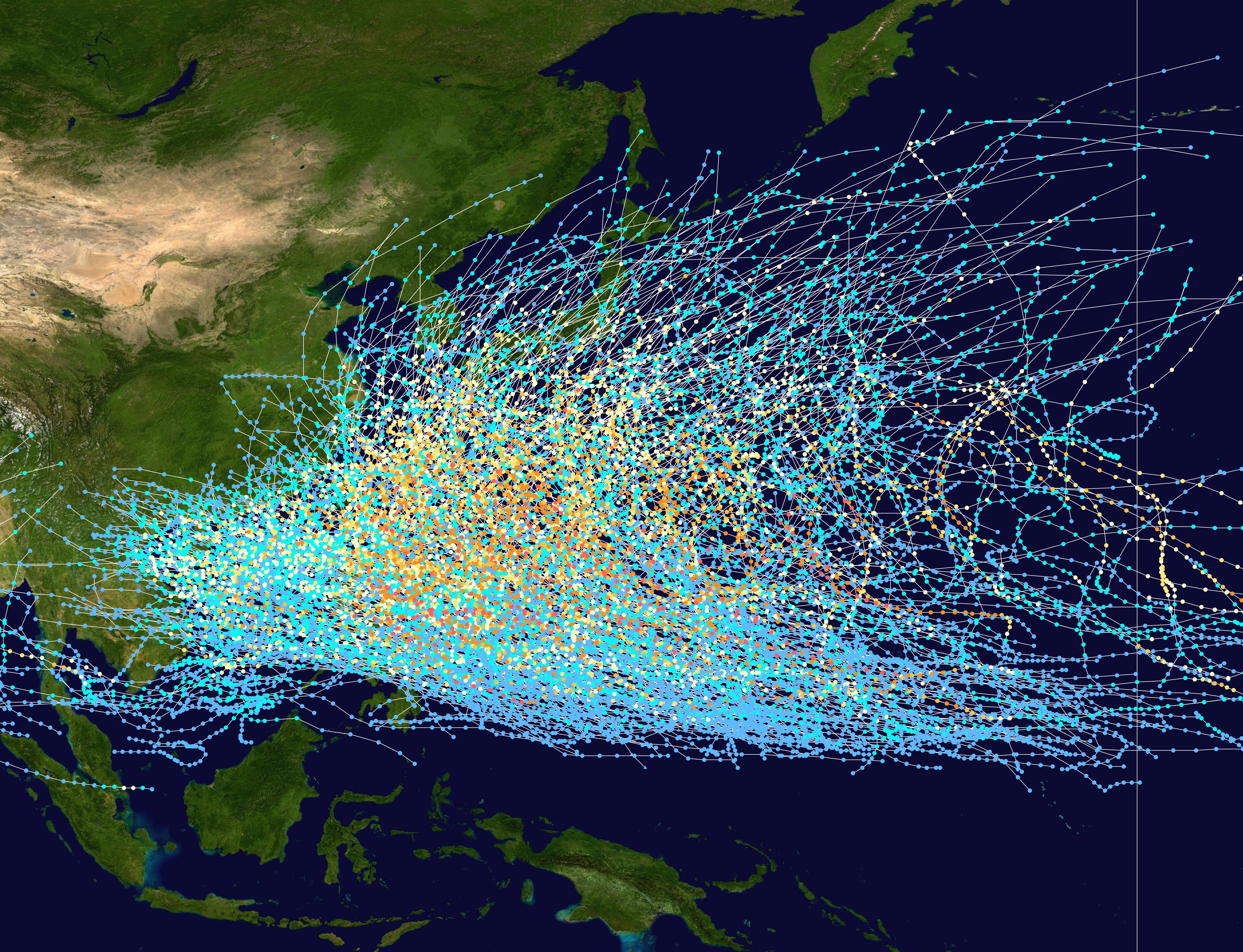
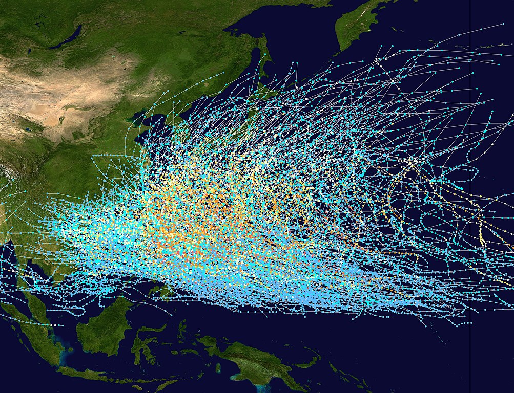
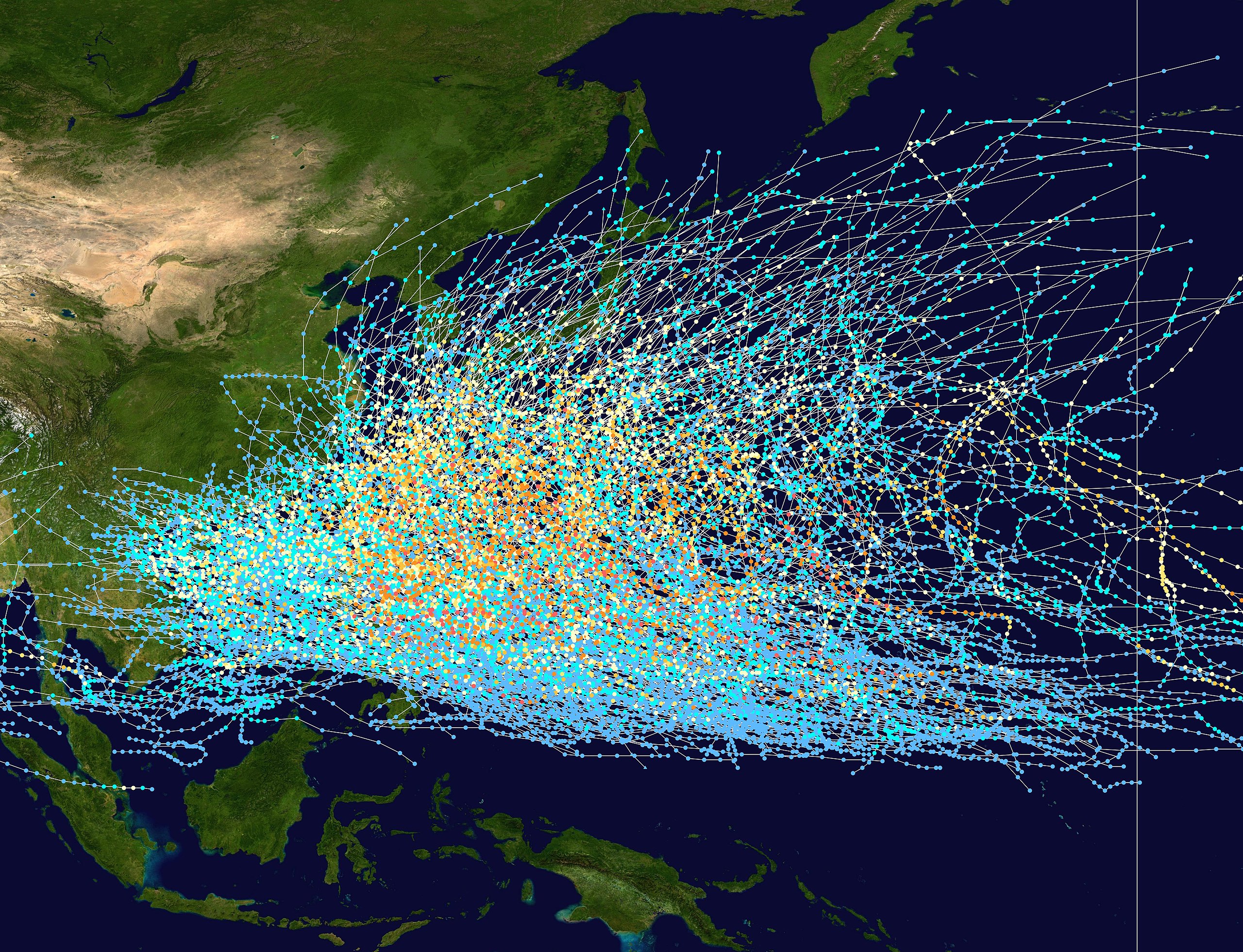
in the
Northwest Pacific Ocean from 1980 to 2005. The International Date Line is marked on the map, this is the eastern boundary of the basin.. The points show the location of each storm at 6-hour intervals. The colour represents the storm's
857:
842:
852:
887:
475:
431:
762:
515:
427:
471:
654:
757:
434:"}},"text\/plain":{"en":{"P6216":"copyrighted, dedicated to the public domain by copyright holder"}}}}": -->
69:
65:
61:
57:
53:
47:
114:
82:
280:
478:"}},"text\/plain":{"en":{"P275":"released into the public domain by the copyright holder"}}}}": -->
917:
912:
161:
as classified in the Saffir-Simpson
Hurricane Scale (see below), and the shape of the data points represent the nature of the storm.
284:
501:
457:
945:
This file contains additional information, probably added from the digital camera or scanner used to create or digitize it.
737:
525:
441:
485:
416:
649:
612:
294:
948:
If the file has been modified from its original state, some details may not fully reflect the modified file.
877:
832:
772:
593:
588:
73:
42:
167:
867:
932:
639:
316:
158:
122:
797:
787:
634:
258:
817:
298:
248:
8:
682:
355:
238:
153:
109:
702:
406:
629:
892:
837:
822:
777:
692:
372:
361:
291:
712:
604:
672:
535:
495:
451:
379:, without any conditions, unless such conditions are required by law.
561:
Click on a date/time to view the file as it appeared at that time.
727:
644:
927:
747:
458:
copyrighted, dedicated to the public domain by copyright holder
432:
copyrighted, dedicated to the public domain by copyright holder
717:
288:
807:
184:
Tropical storm (39–73 mph, 63–118 km/h)
178:
Tropical depression (≤38 mph, ≤62 km/h)
368:
In some countries this may not be legally possible; if so:
208:
Category 4 (130–156 mph, 209–251 km/h)
202:
Category 3 (111–129 mph, 178–208 km/h)
261:/ Remnant low / Tropical disturbance / Monsoon depression
196:
Category 2 (96–110 mph, 154–177 km/h)
97:
190:
Category 1 (74–95 mph, 119–153 km/h)
868:
Tala ng panahon ng bagyo sa hilagang-kanlurang
Pasipiko
502:
released into the public domain by the copyright holder
476:
released into the public domain by the copyright holder
655:
Knowledge:Reference desk/Archives/Science/2011 June 20
87:(4,700 × 3,600 pixels, file size: 4.04 MB, MIME type:
623:
663:
559:
214:
Category 5 (≥157 mph, ≥252 km/h)
121:
Commons is a freely licensed media file repository.
902:
281:Knowledge:WikiProject Tropical cyclones/Tracks
102:
267:
139:
304:
275:
14:
913:Danh sách mùa bão Tây Bắc Thái Bình Dương
665:The following other wikis use this file:
375:grants anyone the right to use this work
818:Bacia de formação de ciclones tropicais
703:Knowledge:Auskunft/Archiv/2023/Woche 33
152:This trackmap shows the tracks of all
918:Bão nhiệt đới Tây Bắc Thái Bình Dương
625:The following 6 pages use this file:
400:Typhoon Tracks in the Western Pacific
353:This work has been released into the
347:
133:
823:Avisos e alertas de ciclone tropical
342:
142:Pacific typhoon tracks 1980-2005.jpg
713:Nomenclature des cyclones tropicaux
552:
13:
943:
405:
399:
146:
134:
80:
969:
950:
679:Usage on be-tarask.wikipedia.org
404:
390:
346:
293:. The tracking data is from the
253:
243:
233:
101:
31:
21:
650:User:AleahHahn/Kuroshio Current
387:
147:
660:
613:Saffir-Simpson Hurricane Scale
556:
386:
26:
1:
843:Бассейны тропических циклонов
315:
159:maximum sustained wind speeds
36:
620:
412:Items portrayed in this file
295:Joint Typhoon Warning Center
7:
940:
874:Usage on tyv.wikipedia.org
794:Usage on lez.wikipedia.org
784:Usage on krc.wikipedia.org
724:Usage on hak.wikipedia.org
10:
974:
924:Usage on zh.wikipedia.org
909:Usage on vi.wikipedia.org
899:Usage on uz.wikipedia.org
888:Басейни тропічних циклонів
884:Usage on uk.wikipedia.org
864:Usage on tl.wikipedia.org
849:Usage on th.wikipedia.org
829:Usage on ru.wikipedia.org
814:Usage on pt.wikipedia.org
804:Usage on ms.wikipedia.org
769:Usage on kk.wikipedia.org
754:Usage on ka.wikipedia.org
744:Usage on ja.wikipedia.org
734:Usage on hy.wikipedia.org
709:Usage on fr.wikipedia.org
699:Usage on de.wikipedia.org
689:Usage on be.wikipedia.org
669:Usage on az.wikipedia.org
136:
553:
365:. This applies worldwide.
16:
389:
108:This is a file from the
41:
640:Tropical cyclone basins
610:
589:21:21, 27 February 2007
270:
112:. Information from its
635:Pacific typhoon season
115:description page there
46:Size of this preview:
259:Extratropical cyclone
615:</small> |- |s
168:Saffir–Simpson scale
74:4,700 × 3,600 pixels
70:2,560 × 1,961 pixels
858:แอ่งพายุหมุนเขตร้อน
299:best track database
249:Subtropical cyclone
52:Other resolutions:
853:พายุไต้ฝุ่นแปซิฟิก
66:1,280 × 980 pixels
62:1,003 × 768 pixels
961:
960:
763:ტაიფუნი (ციკლონი)
718:Alerte cyclonique
661:Global file usage
618:
486:copyright license
472:copyright license
398:
384:
383:
369:
341:
340:
312:
311:
154:tropical cyclones
130:
129:
110:Wikimedia Commons
32:Global file usage
965:
951:
673:Tayfun qasırğası
630:Kuroshio Current
601:
563:
442:copyright status
428:copyright status
396:
367:
350:
349:
343:
337:
334:
331:
328:
323:
322:
285:background image
257:
256:
247:
246:
239:Tropical cyclone
237:
236:
151:
143:
137:
126:
105:
104:
98:
92:
90:
77:
58:627 × 480 pixels
54:313 × 240 pixels
48:783 × 600 pixels
973:
972:
968:
967:
966:
964:
963:
962:
939:
659:
619:
607:
599:
555:
554:
551:
550:
549:
548:
547:
546:
545:
544:
542:
532:
531:
530:
528:
513:
512:
511:
510:
509:
508:
507:
506:
504:
492:
491:
490:
488:
469:
468:
467:
466:
465:
464:
463:
462:
460:
448:
447:
446:
444:
425:
424:
423:
422:
421:
419:
403:
402:
401:
377:for any purpose
359:by its author,
335:
332:
329:
326:
321:
313:
263:
262:
254:
251:
244:
241:
234:
231:
223:
222:
221:
219:
215:
213:
209:
207:
203:
201:
197:
195:
191:
189:
185:
183:
179:
177:
172:
162:
141:
132:
131:
120:
119:
118:is shown below.
94:
88:
86:
79:
78:
51:
12:
11:
5:
971:
959:
958:
955:
942:
938:
937:
936:
935:
930:
922:
921:
920:
915:
907:
906:
905:
897:
896:
895:
890:
882:
881:
880:
872:
871:
870:
862:
861:
860:
855:
847:
846:
845:
840:
835:
827:
826:
825:
820:
812:
811:
810:
808:Siklon tropika
802:
801:
800:
792:
791:
790:
782:
781:
780:
775:
767:
766:
765:
760:
752:
751:
750:
742:
741:
740:
738:Խաղաղ օվկիանոս
732:
731:
730:
722:
721:
720:
715:
707:
706:
705:
697:
696:
695:
687:
686:
685:
677:
676:
675:
662:
658:
657:
652:
647:
642:
637:
632:
622:
617:
616:
609:
605:
602:
598:4,700 × 3,600
596:
591:
586:
582:
581:
578:
575:
572:
569:
566:
558:
543:
540:
538:
537:
536:
534:
533:
529:
524:
522:
521:
520:
519:
517:
505:
500:
498:
497:
496:
494:
493:
489:
484:
482:
481:
480:
479:
477:
473:
461:
456:
454:
453:
452:
450:
449:
445:
440:
438:
437:
436:
435:
433:
429:
420:
415:
413:
410:
409:
408:
407:
395:
394:
391:
388:
382:
381:
351:
339:
338:
320:
314:
310:
309:
306:
302:
301:
279:Created using
277:
273:
272:
269:
265:
264:
252:
242:
232:
225:
224:
217:
216:
211:
210:
205:
204:
199:
198:
193:
192:
187:
186:
181:
180:
175:
174:
173:
164:
163:
144:
135:
128:
127:
106:
96:
95:
45:
40:
39:
34:
29:
24:
19:
9:
6:
4:
3:
2:
970:
956:
953:
952:
949:
946:
934:
931:
929:
926:
925:
923:
919:
916:
914:
911:
910:
908:
904:
901:
900:
898:
894:
891:
889:
886:
885:
883:
879:
876:
875:
873:
869:
866:
865:
863:
859:
856:
854:
851:
850:
848:
844:
841:
839:
836:
834:
831:
830:
828:
824:
821:
819:
816:
815:
813:
809:
806:
805:
803:
799:
796:
795:
793:
789:
786:
785:
783:
779:
776:
774:
771:
770:
768:
764:
761:
759:
758:წყნარი ოკეანე
756:
755:
753:
749:
746:
745:
743:
739:
736:
735:
733:
729:
726:
725:
723:
719:
716:
714:
711:
710:
708:
704:
701:
700:
698:
694:
691:
690:
688:
684:
681:
680:
678:
674:
671:
670:
668:
667:
666:
656:
653:
651:
648:
646:
643:
641:
638:
636:
633:
631:
628:
627:
626:
614:
608:
603:
597:
595:
592:
590:
587:
584:
583:
579:
576:
573:
570:
567:
565:
564:
562:
539:
527:
523:
503:
499:
487:
483:
459:
455:
443:
439:
418:
414:
411:
392:
385:
380:
378:
374:
370:
366:
364:
363:
358:
357:
356:public domain
352:
345:
344:
330:Public domain
327:Public domain
325:
324:
318:
307:
303:
300:
296:
292:
290:
286:
282:
278:
274:
266:
260:
250:
240:
230:
229:
171:
170:
169:
160:
155:
150:
145:
138:
124:
117:
116:
111:
107:
100:
99:
93:
84:
83:Original file
75:
71:
67:
63:
59:
55:
49:
44:
38:
35:
33:
30:
28:
25:
23:
20:
18:
15:
947:
944:
664:
624:
560:
557:File history
376:
371:
360:
354:
227:
226:
166:
165:
148:
123:You can help
113:
81:
22:File history
878:Оожум океан
833:Тихий океан
773:Тынық мұхит
140:Description
954:_error
728:Fûng-chhâi
621:File usage
574:Dimensions
541:image/jpeg
526:media type
516:media type
228:Storm type
89:image/jpeg
27:File usage
798:Лас океан
788:Шош океан
606:Nilfanion
600:(4.04 MB)
571:Thumbnail
568:Date/Time
373:Nilfanion
362:Nilfanion
317:Licensing
308:Nilfanion
271:1980–2005
149:English:
941:Metadata
393:Captions
287:is from
37:Metadata
645:Typhoon
585:current
580:Comment
417:depicts
397:English
220:Unknown
85:
933:熱帶氣旋洋盆
903:Tayfun
893:Тайфун
838:Тайфун
778:Тайфун
693:Тайфун
683:Тайфун
305:Author
283:. The
276:Source
218:
212:
206:
200:
194:
188:
182:
176:
336:false
333:false
577:User
289:NASA
268:Date
17:File
297:'s
928:颱風
748:台風
72:|
68:|
64:|
60:|
56:|
50:.
957:0
319::
125:.
91:)
76:.
Text is available under the Creative Commons Attribution-ShareAlike License. Additional terms may apply.