785:"}},"text\/plain":{"en":{"":"coordinates of depicted place"}}},"{\"value\":{\"latitude\":52.58773,\"longitude\":-3.5813,\"altitude\":null,\"precision\":1.0e-5,\"globe\":\"http:\\\/\\\/www.wikidata.org\\\/entity\\\/Q2\"},\"type\":\"globecoordinate\"}":{"text\/html":{"en":{"P9149":"52\u00b035'15.83"N, 3\u00b034'52.68"W"}},"text\/plain":{"en":{"P9149":"52\u00b035'15.83\"N, 3\u00b034'52.68\"W"}}}}": -->
445:"}},"text\/plain":{"en":{"":"author name string"}}},"{\"value\":\"OLU\",\"type\":\"string\"}":{"text\/html":{"en":{"P2093":"OLU"}},"text\/plain":{"en":{"P2093":"OLU"}}},"{\"value\":{\"entity-type\":\"property\",\"numeric-id\":3831,\"id\":\"P3831\"},\"type\":\"wikibase-entityid\"}":{"text\/html":{"en":{"":"
628:"}},"text\/plain":{"en":{"":"inception"}}},"{\"value\":{\"time\":\"+2001-05-24T00:00:00Z\",\"timezone\":0,\"before\":0,\"after\":0,\"precision\":11,\"calendarmodel\":\"http:\\\/\\\/www.wikidata.org\\\/entity\\\/Q1985727\"},\"type\":\"time\"}":{"text\/html":{"en":{"P571":"24 May 2001"}},"text\/plain":{"en":{"P571":"24 May 2001"}}}}": -->
43:
662:
429:
241:
265:
303:
308:
87:
861:
441:"}},"text\/plain":{"en":{"P2699":"https:\/\/www.geograph.org.uk\/profile\/14997"}}},"{\"value\":{\"entity-type\":\"property\",\"numeric-id\":2093,\"id\":\"P2093\"},\"type\":\"wikibase-entityid\"}":{"text\/html":{"en":{"":"
670:"}},"text\/plain":{"en":{"P7482":"file available on the internet"}}},"{\"value\":{\"entity-type\":\"property\",\"numeric-id\":137,\"id\":\"P137\"},\"type\":\"wikibase-entityid\"}":{"text\/html":{"en":{"":"
678:"}},"text\/plain":{"en":{"P137":"Geograph Britain and Ireland"}}},"{\"value\":{\"entity-type\":\"property\",\"numeric-id\":7384,\"id\":\"P7384\"},\"type\":\"wikibase-entityid\"}":{"text\/html":{"en":{"":"
449:"}},"text\/plain":{"en":{"":"object of statement has role"}}},"{\"value\":{\"entity-type\":\"item\",\"numeric-id\":33231,\"id\":\"Q33231\"},\"type\":\"wikibase-entityid\"}":{"text\/html":{"en":{"P3831":"
584:"}},"text\/plain":{"en":{"":"copyright license"}}},"{\"value\":{\"entity-type\":\"item\",\"numeric-id\":19068220,\"id\":\"Q19068220\"},\"type\":\"wikibase-entityid\"}":{"text\/html":{"en":{"P275":"
540:"}},"text\/plain":{"en":{"":"copyright status"}}},"{\"value\":{\"entity-type\":\"item\",\"numeric-id\":50423863,\"id\":\"Q50423863\"},\"type\":\"wikibase-entityid\"}":{"text\/html":{"en":{"P6216":"
666:"}},"text\/plain":{"en":{"":"source of file"}}},"{\"value\":{\"entity-type\":\"item\",\"numeric-id\":74228490,\"id\":\"Q74228490\"},\"type\":\"wikibase-entityid\"}":{"text\/html":{"en":{"P7482":"
674:"}},"text\/plain":{"en":{"":"operator"}}},"{\"value\":{\"entity-type\":\"item\",\"numeric-id\":1503119,\"id\":\"Q1503119\"},\"type\":\"wikibase-entityid\"}":{"text\/html":{"en":{"P137":"
686:"}},"text\/plain":{"en":{"P7384":"195516"}}},"{\"value\":{\"entity-type\":\"property\",\"numeric-id\":973,\"id\":\"P973\"},\"type\":\"wikibase-entityid\"}":{"text\/html":{"en":{"":"
433:"}},"text\/plain":{"en":{"":"creator"}}},"{\"value\":{\"entity-type\":\"property\",\"numeric-id\":2699,\"id\":\"P2699\"},\"type\":\"wikibase-entityid\"}":{"text\/html":{"en":{"":"
781:
437:"}},"text\/plain":{"en":{"":"URL"}}},"{\"value\":\"https:\\\/\\\/www.geograph.org.uk\\\/profile\\\/14997\",\"type\":\"string\"}":{"text\/html":{"en":{"P2699":"
682:"}},"text\/plain":{"en":{"":"geograph.org.uk image ID"}}},"{\"value\":\"195516\",\"type\":\"string\"}":{"text\/html":{"en":{"P7384":"
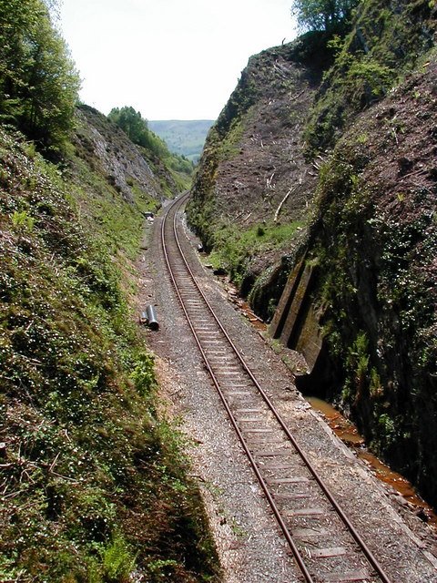
878:== {{int:filedesc}} == {{Information |Description={{en|1=Railway Cutting at the summit of Talerddig bank, near to Talerddig, Powys, Great Britain. At just over 700 feet at the summit, Talerddig has always presented a challenge to railway operators and in
141:
Railway
Cutting at the summit of Talerddig bank, near to Talerddig, Powys, Great Britain. At just over 700 feet at the summit, Talerddig has always presented a challenge to railway operators and in steam days most trains required an assisting
53:
47:
98:
66:
355:– You must give appropriate credit, provide a link to the license, and indicate if changes were made. You may do so in any reasonable manner, but not in any way that suggests the licensor endorses you or your use.
224:
871:
683:
667:
585:
541:
675:
450:
782:
679:
663:
537:
446:
442:
434:
438:
691:
687:
671:
625:
581:
430:
1087:
860:
855:
57:
42:
588:"}},"text\/plain":{"en":{"P275":"Creative Commons Attribution-ShareAlike 2.0 Generic"}}}}": -->
196:
694:"}},"text\/plain":{"en":{"P973":"https:\/\/www.geograph.org.uk\/photo\/195516"}}}}": -->
717:
611:
567:
234:
737:
272:
973:
This file contains additional information, probably added from the digital camera or scanner used to create or digitize it.
362:
522:
792:
745:
701:
551:
515:
502:
487:
760:
730:
635:
595:
460:
419:
897:
1118:
318:
976:
If the file has been modified from its original state, some details may not fully reflect the modified file.
361:– If you remix, transform, or build upon the material, you must distribute your contributions under the
279:
on the
Geograph website for the photographer's contact details. The copyright on this image is owned by
453:"}},"text\/plain":{"en":{"P3831":"photographer"}}}}": -->
544:"}},"text\/plain":{"en":{"P6216":"copyrighted"}}}}": -->
993:
106:
1145:
494:
767:
752:
315:
8:
1181:
259:
240:
284:
93:
409:
892:
170:
131:
Railway
Cutting at the summit of Talerddig bank - geograph.org.uk - 195516.jpg
1163:
1010:
930:
185:
1050:
162:
1191:
1003:
802:
711:
645:
605:
561:
470:
264:
1030:
920:
902:
276:
1020:
828:
Click on a date/time to view the file as it appeared at that time.
226:
960:
174:
166:
219:
52° 35′ 15.8″ N, 3° 34′ 53″ W
151:
81:
940:
403:
Add a one-line explanation of what this file represents
950:
886:
911:
826:
203:
Creative
Commons Attribution Share-alike license 2.0
105:
Commons is a freely licensed media file repository.
612:
Creative
Commons Attribution-ShareAlike 2.0 Generic
586:
Creative
Commons Attribution-ShareAlike 2.0 Generic
71:(480 × 640 pixels, file size: 156 KB, MIME type:
372:https://creativecommons.org/licenses/by-sa/2.0
86:
439:https:\/\/www.geograph.org.uk\/profile\/14997
378:Creative Commons Attribution-Share Alike 2.0
296:
191:
147:
128:
692:https:\/\/www.geograph.org.uk\/photo\/195516
181:
157:
14:
338:– to copy, distribute and transmit the work
913:The following other wikis use this file:
495:https://www.geograph.org.uk/profile/14997
768:https://www.geograph.org.uk/photo/195516
233:View this and other nearby images on:
888:The following 3 pages use this file:
117:
283:and is licensed for reuse under the
209:
819:
319:Attribution-Share Alike 2.0 Generic
307:
302:
287:Attribution-ShareAlike 2.0 license.
13:
971:
408:
402:
293:
270:
135:
118:
64:
1208:
978:
407:
1041:Date and time of data generation
393:
349:Under the following conditions:
314:This file is licensed under the
306:
301:
295:
263:
239:
225:
85:
31:
21:
985:OLYMPUS DIGITAL CAMERA
898:Newtown and Machynlleth Railway
873:File Upload Bot (Magnus Manske)
390:
136:
1015:1/283 sec (0.0035335689045936)
908:
823:
718:file available on the internet
668:file available on the internet
389:
271:This image was taken from the
26:
1:
793:coordinates of depicted place
783:coordinates of depicted place
36:
883:
738:Geograph Britain and Ireland
676:Geograph Britain and Ireland
516:object of statement has role
447:object of statement has role
415:Items portrayed in this file
255:
7:
1129:Date and time of digitizing
968:
937:Usage on li.wiktionary.org
808:52°35'15.83"N, 3°34'52.68"W
10:
1213:
957:Usage on zh.wikipedia.org
947:Usage on www.wikidata.org
927:Usage on fr.wikipedia.org
917:Usage on de.wikipedia.org
363:same or compatible license
125:
120:
1094:File change date and time
820:
16:
921:Einschnitt (Verkehrsweg)
746:geograph.org.uk image ID
680:geograph.org.uk image ID
392:
329:
92:This is a file from the
41:
994:OLYMPUS OPTICAL CO.,LTD
877:
150:
96:. Information from its
1137:Image compression mode
1088:OLYMPUS CAMEDIA Master
931:Tranchée (génie civil)
277:this photograph's page
245:52.587730; -3.581300
99:description page there
46:Size of this preview:
1155:Maximum land aperture
1068:Horizontal resolution
175:geograph_org2commons
1102:Y and C positioning
1076:Vertical resolution
990:Camera manufacturer
856:20:23, 7 April 2010
344:– to adapt the work
52:Other resolutions:
1186:Flash did not fire
1132:10:51, 24 May 2001
1097:15:05, 24 May 2001
1044:10:51, 24 May 2001
503:author name string
443:author name string
1200:
1199:
909:Global file usage
881:
596:copyright license
582:copyright license
401:
292:
291:
275:collection. See
250:
249:
207:
206:
200:
197:Reusing this file
169:; transferred by
114:
113:
94:Wikimedia Commons
32:Global file usage
1204:
1110:Exposure Program
979:
893:Cut (earthworks)
868:
830:
770:
765:
761:described at URL
755:
750:
740:
735:
688:described at URL
552:copyright status
538:copyright status
525:
520:
510:
507:
497:
492:
399:
385:
382:
379:
376:
373:
365:as the original.
327:
316:Creative Commons
310:
309:
305:
304:
299:
298:
285:Creative Commons
273:Geograph project
267:
260:
246:
243:
229:
228:
222:
221:
210:
194:
153:
140:
132:
126:
110:
89:
88:
82:
76:
74:
61:
58:480 × 640 pixels
54:180 × 240 pixels
48:450 × 600 pixels
1212:
1211:
1207:
1206:
1205:
1203:
1202:
1201:
1158:3 APEX (f/2.83)
967:
907:
882:
874:
866:
822:
821:
818:
817:
816:
815:
814:
813:
812:
811:
809:
799:
798:
797:
795:
780:
779:
778:
777:
776:
775:
774:
773:
772:
771:
766:
763:
757:
756:
751:
748:
742:
741:
736:
733:
724:
723:
722:
720:
708:
707:
706:
704:
661:
660:
659:
658:
657:
656:
655:
654:
652:
642:
641:
640:
638:
623:
622:
621:
620:
619:
618:
617:
616:
614:
602:
601:
600:
598:
579:
578:
577:
576:
575:
574:
573:
572:
570:
558:
557:
556:
554:
535:
534:
533:
532:
531:
530:
529:
528:
527:
526:
521:
518:
512:
511:
508:
505:
499:
498:
493:
490:
481:
480:
479:
477:
467:
466:
465:
463:
428:
427:
426:
425:
424:
422:
406:
405:
404:
387:
386:
383:
380:
377:
374:
371:
370:
328:
325:
322:
311:
288:
258:
244:
217:
216:
213:Object location
208:
167:geograph.org.uk
143:
130:
123:
116:
115:
104:
103:
102:is shown below.
78:
72:
70:
63:
62:
51:
12:
11:
5:
1210:
1198:
1197:
1194:
1188:
1187:
1184:
1178:
1177:
1174:
1170:
1169:
1166:
1160:
1159:
1156:
1152:
1151:
1148:
1142:
1141:
1138:
1134:
1133:
1130:
1126:
1125:
1122:
1115:
1114:
1113:Normal program
1111:
1107:
1106:
1103:
1099:
1098:
1095:
1091:
1090:
1085:
1081:
1080:
1077:
1073:
1072:
1069:
1065:
1064:
1061:
1057:
1056:
1053:
1046:
1045:
1042:
1038:
1037:
1034:
1027:
1026:
1023:
1017:
1016:
1013:
1007:
1006:
1001:
997:
996:
991:
987:
986:
983:
970:
966:
965:
964:
963:
955:
954:
953:
945:
944:
943:
935:
934:
933:
925:
924:
923:
910:
906:
905:
900:
895:
885:
880:
879:
876:
872:
869:
863:
858:
853:
849:
848:
845:
842:
839:
836:
833:
825:
810:
807:
805:
804:
803:
801:
800:
796:
791:
789:
788:
787:
786:
784:
759:
758:
744:
743:
729:
728:
727:
726:
725:
721:
716:
714:
713:
712:
710:
709:
705:
702:source of file
700:
698:
697:
696:
695:
693:
689:
685:
681:
677:
673:
669:
665:
664:source of file
653:
650:
648:
647:
646:
644:
643:
639:
634:
632:
631:
630:
629:
627:
615:
610:
608:
607:
606:
604:
603:
599:
594:
592:
591:
590:
589:
587:
583:
571:
566:
564:
563:
562:
560:
559:
555:
550:
548:
547:
546:
545:
543:
539:
514:
513:
501:
500:
486:
485:
484:
483:
482:
478:
475:
473:
472:
471:
469:
468:
464:
459:
457:
456:
455:
454:
452:
448:
444:
440:
436:
432:
423:
418:
416:
413:
412:
411:
410:
398:
397:
394:
391:
369:
368:
367:
366:
356:
347:
346:
345:
339:
332:You are free:
323:
313:
312:
294:
290:
289:
268:
257:
254:
248:
247:
237:
231:
214:
205:
204:
201:
189:
188:
183:
179:
178:
159:
155:
154:
149:
145:
144:
133:
124:
122:
119:
112:
111:
90:
80:
79:
45:
40:
39:
34:
29:
24:
19:
9:
6:
4:
3:
2:
1209:
1195:
1193:
1190:
1189:
1185:
1183:
1180:
1179:
1175:
1172:
1171:
1167:
1165:
1164:Metering mode
1162:
1161:
1157:
1154:
1153:
1149:
1147:
1146:Exposure bias
1144:
1143:
1139:
1136:
1135:
1131:
1128:
1127:
1123:
1120:
1117:
1116:
1112:
1109:
1108:
1104:
1101:
1100:
1096:
1093:
1092:
1089:
1086:
1084:Software used
1083:
1082:
1078:
1075:
1074:
1070:
1067:
1066:
1062:
1059:
1058:
1054:
1052:
1048:
1047:
1043:
1040:
1039:
1035:
1032:
1029:
1028:
1024:
1022:
1019:
1018:
1014:
1012:
1011:Exposure time
1009:
1008:
1005:
1002:
999:
998:
995:
992:
989:
988:
984:
981:
980:
977:
974:
962:
959:
958:
956:
952:
949:
948:
946:
942:
939:
938:
936:
932:
929:
928:
926:
922:
919:
918:
916:
915:
914:
904:
901:
899:
896:
894:
891:
890:
889:
875:
870:
864:
862:
859:
857:
854:
851:
850:
846:
843:
840:
837:
834:
832:
831:
829:
806:
794:
790:
769:
762:
754:
747:
739:
732:
719:
715:
703:
699:
649:
637:
633:
613:
609:
597:
593:
569:
565:
553:
549:
524:
517:
504:
496:
489:
474:
462:
458:
421:
417:
414:
395:
388:
375:CC BY-SA 2.0
364:
360:
357:
354:
351:
350:
348:
343:
340:
337:
334:
333:
331:
330:
324:Attribution:
320:
317:
300:
286:
282:
278:
274:
269:
266:
262:
261:
253:
252:
242:
238:
236:
235:OpenStreetMap
232:
230:
220:
215:
212:
211:
202:
198:
193:
190:
187:
184:
180:
176:
172:
171:User:RHaworth
168:
164:
160:
156:
146:
139:
134:
127:
108:
101:
100:
95:
91:
84:
83:
77:
68:
67:Original file
59:
55:
49:
44:
38:
35:
33:
30:
28:
25:
23:
20:
18:
15:
1173:Light source
1051:focal length
1000:Camera model
975:
972:
912:
887:
827:
824:File history
523:photographer
451:photographer
358:
352:
341:
335:
280:
251:
137:
107:You can help
97:
65:
22:File history
1192:Color space
1060:Orientation
1004:C960Z,D460Z
982:Image title
651:24 May 2001
568:copyrighted
542:copyrighted
359:share alike
353:attribution
152:24 May 2001
129:Description
941:aafgraving
884:File usage
865:480 × 640
841:Dimensions
476:some value
192:Permission
163:this image
73:image/jpeg
27:File usage
1031:ISO speed
903:Talerddig
838:Thumbnail
835:Date/Time
636:inception
626:inception
256:Licensing
138:English:
1105:Co-sited
1021:F-number
969:Metadata
951:Q1308978
867:(156 KB)
731:operator
672:operator
396:Captions
342:to remix
336:to share
321:license.
37:Metadata
1176:Unknown
1168:Pattern
1121:version
852:current
847:Comment
461:creator
431:creator
420:depicts
400:English
142:engine.
121:Summary
69:
1079:72 dpi
1071:72 dpi
1063:Normal
1055:5.6 mm
1033:rating
753:195516
684:195516
223:
182:Author
173:using
158:Source
1182:Flash
1049:Lens
161:From
1196:sRGB
1119:Exif
844:User
384:true
381:true
148:Date
17:File
1124:2.1
1036:125
1025:f/8
509:OLU
488:URL
435:URL
326:OLU
281:OLU
186:OLU
165:at
961:路堑
764::
749::
734::
519::
506::
491::
56:|
50:.
1150:0
1140:1
199:)
195:(
177:.
109:.
75:)
60:.
Text is available under the Creative Commons Attribution-ShareAlike License. Additional terms may apply.
_region:GB-GBN_&language=en)
