884:"}},"text\/plain":{"en":{"":"coordinates of the point of view"}}},"{\"value\":{\"latitude\":51.636404,\"longitude\":-0.466258,\"altitude\":null,\"precision\":1.0e-6,\"globe\":\"http:\\\/\\\/www.wikidata.org\\\/entity\\\/Q2\"},\"type\":\"globecoordinate\"}":{"text\/html":{"en":{"P1259":"51\u00b038'11.054"N, 0\u00b027'58.529"W"}},"text\/plain":{"en":{"P1259":"51\u00b038'11.054\"N, 0\u00b027'58.529\"W"}}},"{\"value\":{\"entity-type\":\"property\",\"numeric-id\":7787,\"id\":\"P7787\"},\"type\":\"wikibase-entityid\"}":{"text\/html":{"en":{"":"
952:"}},"text\/plain":{"en":{"":"coordinates of depicted place"}}},"{\"value\":{\"latitude\":51.63637,\"longitude\":-0.4671,\"altitude\":null,\"precision\":1.0e-5,\"globe\":\"http:\\\/\\\/www.wikidata.org\\\/entity\\\/Q2\"},\"type\":\"globecoordinate\"}":{"text\/html":{"en":{"P9149":"51\u00b038'10.93"N, 0\u00b028'1.56"W"}},"text\/plain":{"en":{"P9149":"51\u00b038'10.93\"N, 0\u00b028'1.56\"W"}}},"{\"value\":{\"entity-type\":\"property\",\"numeric-id\":7787,\"id\":\"P7787\"},\"type\":\"wikibase-entityid\"}":{"text\/html":{"en":{"":"
43:
544:"}},"text\/plain":{"en":{"":"author name string"}}},"{\"value\":\"David Hillas\",\"type\":\"string\"}":{"text\/html":{"en":{"P2093":"David Hillas"}},"text\/plain":{"en":{"P2093":"David Hillas"}}},"{\"value\":{\"entity-type\":\"property\",\"numeric-id\":3831,\"id\":\"P3831\"},\"type\":\"wikibase-entityid\"}":{"text\/html":{"en":{"":"
846:"}},"text\/plain":{"en":{"":"inception"}}},"{\"value\":{\"time\":\"+1972-03-18T00:00:00Z\",\"timezone\":0,\"before\":0,\"after\":0,\"precision\":11,\"calendarmodel\":\"http:\\\/\\\/www.wikidata.org\\\/entity\\\/Q1985727\"},\"type\":\"time\"}":{"text\/html":{"en":{"P571":"18 March 1972"}},"text\/plain":{"en":{"P571":"18 March 1972"}}}}": -->
723:
329:
279:
321:
271:
948:
293:
364:
402:
407:
1129:
99:
1096:
540:"}},"text\/plain":{"en":{"P2699":"https:\/\/www.geograph.org.uk\/profile\/22410"}}},"{\"value\":{\"entity-type\":\"property\",\"numeric-id\":2093,\"id\":\"P2093\"},\"type\":\"wikibase-entityid\"}":{"text\/html":{"en":{"":"
739:"}},"text\/plain":{"en":{"P973":"https:\/\/www.geograph.org.uk\/photo\/2096337"}}},"{\"value\":{\"entity-type\":\"property\",\"numeric-id\":7384,\"id\":\"P7384\"},\"type\":\"wikibase-entityid\"}":{"text\/html":{"en":{"":"
731:"}},"text\/plain":{"en":{"P7482":"file available on the internet"}}},"{\"value\":{\"entity-type\":\"property\",\"numeric-id\":973,\"id\":\"P973\"},\"type\":\"wikibase-entityid\"}":{"text\/html":{"en":{"":"
548:"}},"text\/plain":{"en":{"":"object of statement has role"}}},"{\"value\":{\"entity-type\":\"item\",\"numeric-id\":33231,\"id\":\"Q33231\"},\"type\":\"wikibase-entityid\"}":{"text\/html":{"en":{"P3831":"
1020:"}},"text\/plain":{"en":{"":"media type"}}},"{\"value\":\"image\\\/jpeg\",\"type\":\"string\"}":{"text\/html":{"en":{"P1163":"image\/jpeg"}},"text\/plain":{"en":{"P1163":"image\/jpeg"}}}}": -->
683:"}},"text\/plain":{"en":{"":"copyright license"}}},"{\"value\":{\"entity-type\":\"item\",\"numeric-id\":19068220,\"id\":\"Q19068220\"},\"type\":\"wikibase-entityid\"}":{"text\/html":{"en":{"P275":"
639:"}},"text\/plain":{"en":{"":"copyright status"}}},"{\"value\":{\"entity-type\":\"item\",\"numeric-id\":50423863,\"id\":\"Q50423863\"},\"type\":\"wikibase-entityid\"}":{"text\/html":{"en":{"P6216":"
727:"}},"text\/plain":{"en":{"":"source of file"}}},"{\"value\":{\"entity-type\":\"item\",\"numeric-id\":74228490,\"id\":\"Q74228490\"},\"type\":\"wikibase-entityid\"}":{"text\/html":{"en":{"P7482":"
956:"}},"text\/plain":{"en":{"":"heading"}}},"{\"value\":{\"amount\":\"+247\",\"unit\":\"http:\\\/\\\/www.wikidata.org\\\/entity\\\/Q28390\"},\"type\":\"quantity\"}":{"text\/html":{"en":{"P7787":"247
888:"}},"text\/plain":{"en":{"":"heading"}}},"{\"value\":{\"amount\":\"+247\",\"unit\":\"http:\\\/\\\/www.wikidata.org\\\/entity\\\/Q28390\"},\"type\":\"quantity\"}":{"text\/html":{"en":{"P7787":"247
751:"}},"text\/plain":{"en":{"":"operator"}}},"{\"value\":{\"entity-type\":\"item\",\"numeric-id\":1503119,\"id\":\"Q1503119\"},\"type\":\"wikibase-entityid\"}":{"text\/html":{"en":{"P137":"
747:"}},"text\/plain":{"en":{"P7384":"2096337"}}},"{\"value\":{\"entity-type\":\"property\",\"numeric-id\":137,\"id\":\"P137\"},\"type\":\"wikibase-entityid\"}":{"text\/html":{"en":{"":"
532:"}},"text\/plain":{"en":{"":"creator"}}},"{\"value\":{\"entity-type\":\"property\",\"numeric-id\":2699,\"id\":\"P2699\"},\"type\":\"wikibase-entityid\"}":{"text\/html":{"en":{"":"
1016:
735:"}},"text\/plain":{"en":{"":"described at URL"}}},"{\"value\":\"https:\\\/\\\/www.geograph.org.uk\\\/photo\\\/2096337\",\"type\":\"string\"}":{"text\/html":{"en":{"P973":"
157:
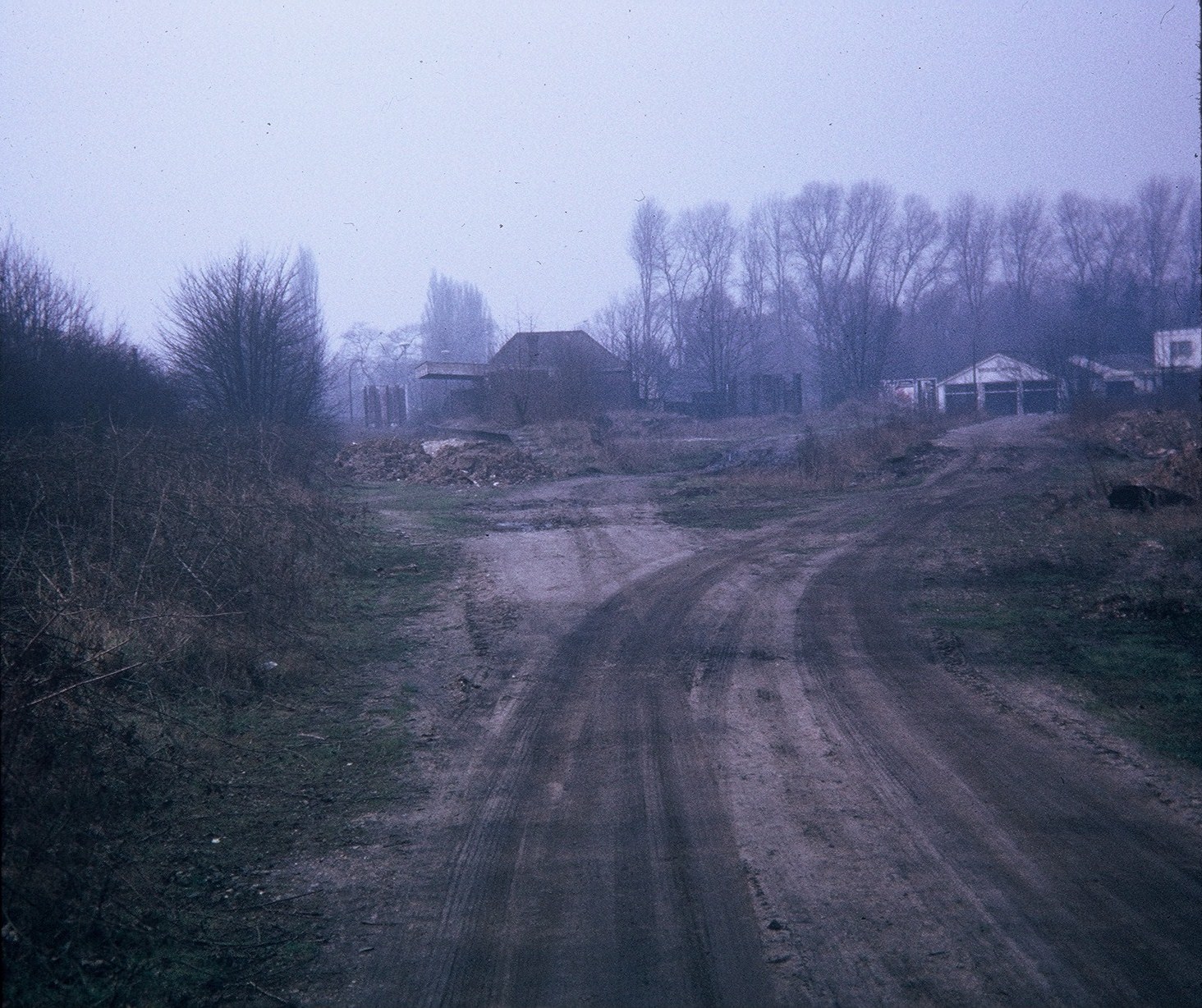
This station was the terminus of the railway line to
Watford which closed to passengers on the 3rd March, 1952. The track was lifted in late 1967 and subsequently became the Ebury Way path. Housing now occupies the station site. Its postcode is WD3 1JF. Bridge Motors garage can be seen in the
536:"}},"text\/plain":{"en":{"":"URL"}}},"{\"value\":\"https:\\\/\\\/www.geograph.org.uk\\\/profile\\\/22410\",\"type\":\"string\"}":{"text\/html":{"en":{"P2699":"
743:"}},"text\/plain":{"en":{"":"geograph.org.uk image ID"}}},"{\"value\":\"2096337\",\"type\":\"string\"}":{"text\/html":{"en":{"P7384":"
262:
65:
61:
57:
53:
47:
78:
110:
454:– You must give appropriate credit, provide a link to the license, and indicate if changes were made. You may do so in any reasonable manner, but not in any way that suggests the licensor endorses you or your use.
276:
326:
1139:
1106:
744:
728:
684:
640:
752:
1128:
1123:
549:
1017:
953:
949:
885:
881:
740:
724:
636:
545:
541:
533:
736:
537:
843:
748:
732:
680:
529:
1095:
1090:
69:
42:
1258:
1163:
687:"}},"text\/plain":{"en":{"P275":"Creative Commons Attribution-ShareAlike 2.0 Generic"}}}}": -->
199:
778:
710:
666:
336:
286:
828:
371:
1194:
This file contains additional information, probably added from the digital camera or scanner used to create or digitize it.
461:
621:
1027:
994:
967:
926:
899:
806:
762:
650:
614:
601:
586:
853:
821:
791:
694:
559:
518:
755:"}},"text\/plain":{"en":{"P137":"Geograph Britain and Ireland"}}}}": -->
1281:
417:
1197:
If the file has been modified from its original state, some details may not fully reflect the modified file.
460:– If you remix, transform, or build upon the material, you must distribute your contributions under the
378:
on the
Geograph website for the photographer's contact details. The copyright on this image is owned by
552:"}},"text\/plain":{"en":{"P3831":"photographer"}}}}": -->
1206:
643:"}},"text\/plain":{"en":{"P6216":"copyrighted"}}}}": -->
960:"}},"text\/plain":{"en":{"P7787":"247 degree"}}}}": -->
892:"}},"text\/plain":{"en":{"P7787":"247 degree"}}}}": -->
118:
231:
813:
798:
593:
414:
215:
8:
358:
342:
292:
383:
105:
508:
188:
178:
1037:
977:
909:
863:
772:
704:
660:
569:
363:
1147:
1114:
143:
Remains of
Rickmansworth (Church Street) Station (geograph 2096337).jpg
375:
1063:
Click on a date/time to view the file as it appeared at that time.
1216:
328:
278:
263:
51° 38′ 11.05″ N, 0° 27′ 58.53″ W
313:
51° 38′ 11″ N, 0° 28′ 02″ W
167:
93:
502:
Add a one-line explanation of what this file represents
1181:
1157:
83:(1,464 × 1,228 pixels, file size: 540 KB, MIME type:
1172:
1061:
206:
Creative
Commons Attribution Share-alike license 2.0
117:
Commons is a freely licensed media file repository.
711:
Creative
Commons Attribution-ShareAlike 2.0 Generic
685:
Creative
Commons Attribution-ShareAlike 2.0 Generic
246:Remains of Rickmansworth (Church Street) Station
227:Remains of Rickmansworth (Church Street) Station
154:Remains of Rickmansworth (Church Street) Station
1259:Microsoft Windows Photo Gallery 6.0.6001.18000
471:https://creativecommons.org/licenses/by-sa/2.0
98:
1164:Rickmansworth (Church Street) railway station
737:https:\/\/www.geograph.org.uk\/photo\/2096337
538:https:\/\/www.geograph.org.uk\/profile\/22410
477:Creative Commons Attribution-Share Alike 2.0
395:
194:
163:
140:
184:
173:
14:
957:
889:
437:– to copy, distribute and transmit the work
1174:The following other wikis use this file:
799:https://www.geograph.org.uk/photo/2096337
594:https://www.geograph.org.uk/profile/22410
335:View this and other nearby images on:
285:View this and other nearby images on:
238:
129:
382:and is licensed for reuse under the
303:
253:
1159:The following page uses this file:
1054:
418:Attribution-Share Alike 2.0 Generic
406:
401:
386:Attribution-ShareAlike 2.0 license.
13:
1192:
507:
501:
392:
369:
147:
130:
76:
1360:
1199:
506:
1348:85D8995E7CD74029B27251A36F7BAE0C
1223:Date and time of data generation
900:coordinates of the point of view
882:coordinates of the point of view
492:
448:Under the following conditions:
413:This file is licensed under the
405:
400:
394:
362:
341:
327:
319:
291:
277:
269:
97:
31:
21:
1141:File Upload Bot (Magnus Manske)
1108:File Upload Bot (Magnus Manske)
489:
148:
1169:
1058:
779:file available on the internet
729:file available on the internet
488:
370:This image was taken from the
26:
1:
1340:A directly photographed image
1146:Transferred from Geograph by
1113:Transferred from Geograph by
968:coordinates of depicted place
950:coordinates of depicted place
915:51°38'11.054"N, 0°27'58.529"W
36:
1154:
829:Geograph Britain and Ireland
753:Geograph Britain and Ireland
615:object of statement has role
546:object of statement has role
514:Items portrayed in this file
354:
318:
268:
7:
1292:Date and time of digitizing
1189:
10:
1365:
1321:Supported Flashpix version
1178:Usage on www.wikidata.org
983:51°38'10.93"N, 0°28'1.56"W
462:same or compatible license
137:
132:
1300:Meaning of each component
1265:File change date and time
1207:FUJI PHOTO FILM CO., LTD.
1055:
244:David Hillas /
225:David Hillas /
16:
1268:21:52, 27 September 2010
807:geograph.org.uk image ID
741:geograph.org.uk image ID
491:
428:
158:background on the right.
104:This is a file from the
41:
1145:
1112:
216:required by the license
166:
108:. Information from its
1124:01:05, 15 January 2015
1091:01:05, 15 January 2015
376:this photograph's page
347:51.636370; -0.467100
297:51.636404; -0.466258
111:description page there
46:Size of this preview:
1239:Horizontal resolution
1332:Digital still camera
1295:08:56, 19 April 2010
70:1,464 × 1,228 pixels
66:1,221 × 1,024 pixels
1273:Y and C positioning
1247:Vertical resolution
1203:Camera manufacturer
443:– to adapt the work
52:Other resolutions:
602:author name string
542:author name string
1352:
1351:
1170:Global file usage
1152:
959:
891:
695:copyright license
681:copyright license
500:
391:
390:
374:collection. See
352:
351:
302:
301:
251:
250:
219:
203:
200:Reusing this file
126:
125:
106:Wikimedia Commons
32:Global file usage
1356:
1200:
1136:
1103:
1065:
1005:
1004:
999:
937:
936:
931:
831:
826:
816:
811:
801:
796:
792:described at URL
733:described at URL
651:copyright status
637:copyright status
624:
619:
609:
606:
596:
591:
498:
484:
481:
478:
475:
472:
464:as the original.
426:
415:Creative Commons
409:
408:
404:
403:
398:
397:
384:Creative Commons
372:Geograph project
366:
359:
348:
345:
331:
330:
324:
323:
322:
316:
315:
304:
298:
295:
281:
280:
274:
273:
272:
266:
265:
254:
213:
197:
169:
152:
144:
138:
122:
101:
100:
94:
88:
86:
73:
62:916 × 768 pixels
58:572 × 480 pixels
54:286 × 240 pixels
48:715 × 600 pixels
1364:
1363:
1359:
1358:
1357:
1355:
1354:
1353:
1345:Unique image ID
1188:
1168:
1153:
1142:
1134:
1109:
1101:
1057:
1056:
1053:
1052:
1051:
1050:
1049:
1048:
1047:
1046:
1044:
1034:
1033:
1032:
1030:
1015:
1014:
1013:
1012:
1011:
1010:
1009:
1008:
1007:
1006:
1002:
1000:
997:
988:
987:
986:
984:
974:
973:
972:
970:
947:
946:
945:
944:
943:
942:
941:
940:
939:
938:
934:
932:
929:
920:
919:
918:
916:
906:
905:
904:
902:
879:
878:
877:
876:
875:
874:
873:
872:
870:
860:
859:
858:
856:
841:
840:
839:
838:
837:
836:
835:
834:
833:
832:
827:
824:
818:
817:
812:
809:
803:
802:
797:
794:
785:
784:
783:
781:
769:
768:
767:
765:
722:
721:
720:
719:
718:
717:
716:
715:
713:
701:
700:
699:
697:
678:
677:
676:
675:
674:
673:
672:
671:
669:
657:
656:
655:
653:
634:
633:
632:
631:
630:
629:
628:
627:
626:
625:
620:
617:
611:
610:
607:
604:
598:
597:
592:
589:
580:
579:
578:
576:
566:
565:
564:
562:
527:
526:
525:
524:
523:
521:
505:
504:
503:
486:
485:
482:
479:
476:
473:
470:
469:
427:
424:
421:
410:
387:
357:
346:
320:
311:
310:
307:Object location
296:
270:
261:
260:
257:Camera location
252:
241:
234:
222:
179:geograph.org.uk
159:
142:
135:
128:
127:
116:
115:
114:is shown below.
90:
84:
82:
75:
74:
51:
12:
11:
5:
1362:
1350:
1349:
1346:
1342:
1341:
1338:
1334:
1333:
1330:
1326:
1325:
1322:
1318:
1317:
1316:
1315:
1314:does not exist
1312:
1309:
1306:
1301:
1297:
1296:
1293:
1289:
1288:
1285:
1278:
1277:
1274:
1270:
1269:
1266:
1262:
1261:
1256:
1252:
1251:
1248:
1244:
1243:
1240:
1236:
1235:
1232:
1228:
1227:
1224:
1220:
1219:
1214:
1210:
1209:
1204:
1191:
1187:
1186:
1185:
1184:
1171:
1167:
1166:
1156:
1151:
1150:
1144:
1140:
1137:
1133:1,464 × 1,228
1131:
1126:
1121:
1118:
1117:
1111:
1107:
1104:
1100:1,464 × 1,228
1098:
1093:
1088:
1084:
1083:
1080:
1077:
1074:
1071:
1068:
1060:
1045:
1042:
1040:
1039:
1038:
1036:
1035:
1031:
1026:
1024:
1023:
1022:
1021:
1019:
993:
992:
991:
990:
989:
985:
982:
980:
979:
978:
976:
975:
971:
966:
964:
963:
962:
961:
955:
951:
925:
924:
923:
922:
921:
917:
914:
912:
911:
910:
908:
907:
903:
898:
896:
895:
894:
893:
887:
883:
871:
868:
866:
865:
864:
862:
861:
857:
852:
850:
849:
848:
847:
845:
820:
819:
805:
804:
790:
789:
788:
787:
786:
782:
777:
775:
774:
773:
771:
770:
766:
763:source of file
761:
759:
758:
757:
756:
754:
750:
746:
742:
738:
734:
730:
726:
725:source of file
714:
709:
707:
706:
705:
703:
702:
698:
693:
691:
690:
689:
688:
686:
682:
670:
665:
663:
662:
661:
659:
658:
654:
649:
647:
646:
645:
644:
642:
638:
613:
612:
600:
599:
585:
584:
583:
582:
581:
577:
574:
572:
571:
570:
568:
567:
563:
558:
556:
555:
554:
553:
551:
547:
543:
539:
535:
531:
522:
517:
515:
512:
511:
510:
509:
497:
496:
493:
490:
468:
467:
466:
465:
455:
446:
445:
444:
438:
431:You are free:
422:
412:
411:
393:
389:
388:
367:
356:
353:
350:
349:
339:
333:
308:
300:
299:
289:
283:
258:
249:
248:
242:
239:
236:
235:
230:
223:
220:
208:
207:
204:
192:
191:
186:
182:
181:
175:
171:
170:
165:
161:
160:
145:
136:
134:
131:
124:
123:
102:
92:
91:
45:
40:
39:
34:
29:
24:
19:
9:
6:
4:
3:
2:
1361:
1347:
1344:
1343:
1339:
1336:
1335:
1331:
1328:
1327:
1323:
1320:
1319:
1313:
1310:
1307:
1304:
1303:
1302:
1299:
1298:
1294:
1291:
1290:
1286:
1283:
1280:
1279:
1275:
1272:
1271:
1267:
1264:
1263:
1260:
1257:
1255:Software used
1254:
1253:
1249:
1246:
1245:
1241:
1238:
1237:
1233:
1230:
1229:
1225:
1222:
1221:
1218:
1215:
1212:
1211:
1208:
1205:
1202:
1201:
1198:
1195:
1183:
1180:
1179:
1177:
1176:
1175:
1165:
1162:
1161:
1160:
1149:
1143:
1138:
1132:
1130:
1127:
1125:
1122:
1120:
1119:
1116:
1110:
1105:
1099:
1097:
1094:
1092:
1089:
1086:
1085:
1081:
1078:
1075:
1072:
1069:
1067:
1066:
1064:
1041:
1029:
1025:
996:
981:
969:
965:
928:
913:
901:
897:
869:18 March 1972
867:
855:
851:
830:
823:
815:
808:
800:
793:
780:
776:
764:
760:
712:
708:
696:
692:
668:
664:
652:
648:
623:
616:
603:
595:
588:
573:
561:
557:
520:
516:
513:
494:
487:
474:CC BY-SA 2.0
463:
459:
456:
453:
450:
449:
447:
442:
439:
436:
433:
432:
430:
429:
423:Attribution:
419:
416:
399:
385:
381:
377:
373:
368:
365:
361:
360:
344:
340:
338:
337:OpenStreetMap
334:
332:
314:
309:
306:
305:
294:
290:
288:
287:OpenStreetMap
284:
282:
264:
259:
256:
255:
247:
243:
237:
233:
229: /
228:
224:
217:
212:
210:
209:
205:
201:
196:
193:
190:
187:
183:
180:
176:
172:
168:18 March 1972
162:
156:
155:
151:
146:
139:
120:
113:
112:
107:
103:
96:
95:
89:
80:
79:Original file
71:
67:
63:
59:
55:
49:
44:
38:
35:
33:
30:
28:
25:
23:
20:
18:
15:
1226:Unknown date
1213:Camera model
1196:
1193:
1173:
1158:
1062:
1059:File history
622:photographer
608:David Hillas
550:photographer
457:
451:
440:
434:
425:David Hillas
380:David Hillas
379:
317:
267:
245:
232:CC BY-SA 2.0
226:
189:David Hillas
153:
149:
119:You can help
109:
77:
22:File history
1329:File source
1231:Orientation
667:copyrighted
641:copyrighted
458:share alike
452:attribution
211:Attribution
141:Description
1337:Scene type
1155:File usage
1148:User:cnbrb
1115:User:cnbrb
1076:Dimensions
1043:image/jpeg
1028:media type
1018:media type
575:some value
195:Permission
85:image/jpeg
27:File usage
1073:Thumbnail
1070:Date/Time
854:inception
844:inception
355:Licensing
240:InfoField
221:InfoField
150:English:
1276:Centered
1190:Metadata
1182:Q7331988
1135:(540 KB)
1102:(540 KB)
822:operator
749:operator
495:Captions
441:to remix
435:to share
420:license.
37:Metadata
1284:version
1217:SP-2000
1087:current
1082:Comment
995:heading
954:heading
927:heading
886:heading
814:2096337
745:2096337
560:creator
530:creator
519:depicts
499:English
133:Summary
81:
1250:72 dpi
1242:72 dpi
1234:Normal
1003:degree
958:degree
935:degree
890:degree
325:
275:
185:Author
174:Source
177:From
1282:Exif
1079:User
1001:247
933:247
483:true
480:true
164:Date
17:File
1287:2.1
587:URL
534:URL
1311:Cr
1308:Cb
998::
930::
825::
810::
795::
618::
605::
590::
68:|
64:|
60:|
56:|
50:.
1324:1
1305:Y
218:)
214:(
202:)
198:(
121:.
87:)
72:.
Text is available under the Creative Commons Attribution-ShareAlike License. Additional terms may apply.
_Station_(geograph_2096337).jpg)
_Station_(geograph_2096337).jpg¶ms=051.636404_N_-000.466258_E_globe:Earth_type:camera_heading:247.00_source:geograph&language=en)
_Station_(geograph_2096337).jpg¶ms=051.636370_N_-000.467100_E_globe:Earth_class:object_type:object_source:geograph-osgb36(TQ06189417)_region:GB-GBN_heading:247.00&language=en)
