783:"}},"text\/plain":{"en":{"":"coordinates of the point of view"}}},"{\"value\":{\"latitude\":51.803626,\"longitude\":-2.70479,\"altitude\":null,\"precision\":1.0e-6,\"globe\":\"http:\\\/\\\/www.wikidata.org\\\/entity\\\/Q2\"},\"type\":\"globecoordinate\"}":{"text\/html":{"en":{"P1259":"51\u00b048'13.054"N, 2\u00b042'17.244"W"}},"text\/plain":{"en":{"P1259":"51\u00b048'13.054\"N, 2\u00b042'17.244\"W"}}},"{\"value\":{\"entity-type\":\"property\",\"numeric-id\":7787,\"id\":\"P7787\"},\"type\":\"wikibase-entityid\"}":{"text\/html":{"en":{"":"
443:"}},"text\/plain":{"en":{"":"author name string"}}},"{\"value\":\"Ralph Rawlinson\",\"type\":\"string\"}":{"text\/html":{"en":{"P2093":"Ralph Rawlinson"}},"text\/plain":{"en":{"P2093":"Ralph Rawlinson"}}},"{\"value\":{\"entity-type\":\"property\",\"numeric-id\":3831,\"id\":\"P3831\"},\"type\":\"wikibase-entityid\"}":{"text\/html":{"en":{"":"
626:"}},"text\/plain":{"en":{"":"inception"}}},"{\"value\":{\"time\":\"+2002-07-08T00:00:00Z\",\"timezone\":0,\"before\":0,\"after\":0,\"precision\":11,\"calendarmodel\":\"http:\\\/\\\/www.wikidata.org\\\/entity\\\/Q1985727\"},\"type\":\"time\"}":{"text\/html":{"en":{"P571":"8 July 2002"}},"text\/plain":{"en":{"P571":"8 July 2002"}}}}": -->
660:
427:
779:
215:
236:
274:
279:
67:
439:"}},"text\/plain":{"en":{"P2699":"https:\/\/www.geograph.org.uk\/profile\/2091"}}},"{\"value\":{\"entity-type\":\"property\",\"numeric-id\":2093,\"id\":\"P2093\"},\"type\":\"wikibase-entityid\"}":{"text\/html":{"en":{"":"
668:"}},"text\/plain":{"en":{"P7482":"file available on the internet"}}},"{\"value\":{\"entity-type\":\"property\",\"numeric-id\":137,\"id\":\"P137\"},\"type\":\"wikibase-entityid\"}":{"text\/html":{"en":{"":"
676:"}},"text\/plain":{"en":{"P137":"Geograph Britain and Ireland"}}},"{\"value\":{\"entity-type\":\"property\",\"numeric-id\":7384,\"id\":\"P7384\"},\"type\":\"wikibase-entityid\"}":{"text\/html":{"en":{"":"
447:"}},"text\/plain":{"en":{"":"object of statement has role"}}},"{\"value\":{\"entity-type\":\"item\",\"numeric-id\":33231,\"id\":\"Q33231\"},\"type\":\"wikibase-entityid\"}":{"text\/html":{"en":{"P3831":"
851:"}},"text\/plain":{"en":{"":"media type"}}},"{\"value\":\"image\\\/jpeg\",\"type\":\"string\"}":{"text\/html":{"en":{"P1163":"image\/jpeg"}},"text\/plain":{"en":{"P1163":"image\/jpeg"}}}}": -->
582:"}},"text\/plain":{"en":{"":"copyright license"}}},"{\"value\":{\"entity-type\":\"item\",\"numeric-id\":19068220,\"id\":\"Q19068220\"},\"type\":\"wikibase-entityid\"}":{"text\/html":{"en":{"P275":"
538:"}},"text\/plain":{"en":{"":"copyright status"}}},"{\"value\":{\"entity-type\":\"item\",\"numeric-id\":50423863,\"id\":\"Q50423863\"},\"type\":\"wikibase-entityid\"}":{"text\/html":{"en":{"P6216":"
664:"}},"text\/plain":{"en":{"":"source of file"}}},"{\"value\":{\"entity-type\":\"item\",\"numeric-id\":74228490,\"id\":\"Q74228490\"},\"type\":\"wikibase-entityid\"}":{"text\/html":{"en":{"P7482":"
787:"}},"text\/plain":{"en":{"":"heading"}}},"{\"value\":{\"amount\":\"+315\",\"unit\":\"http:\\\/\\\/www.wikidata.org\\\/entity\\\/Q28390\"},\"type\":\"quantity\"}":{"text\/html":{"en":{"P7787":"315
672:"}},"text\/plain":{"en":{"":"operator"}}},"{\"value\":{\"entity-type\":\"item\",\"numeric-id\":1503119,\"id\":\"Q1503119\"},\"type\":\"wikibase-entityid\"}":{"text\/html":{"en":{"P137":"
684:"}},"text\/plain":{"en":{"P7384":"58273"}}},"{\"value\":{\"entity-type\":\"property\",\"numeric-id\":973,\"id\":\"P973\"},\"type\":\"wikibase-entityid\"}":{"text\/html":{"en":{"":"
431:"}},"text\/plain":{"en":{"":"creator"}}},"{\"value\":{\"entity-type\":\"property\",\"numeric-id\":2699,\"id\":\"P2699\"},\"type\":\"wikibase-entityid\"}":{"text\/html":{"en":{"":"
847:
688:"}},"text\/plain":{"en":{"":"described at URL"}}},"{\"value\":\"https:\\\/\\\/www.geograph.org.uk\\\/photo\\\/58273\",\"type\":\"string\"}":{"text\/html":{"en":{"P973":"
927:
435:"}},"text\/plain":{"en":{"":"URL"}}},"{\"value\":\"https:\\\/\\\/www.geograph.org.uk\\\/profile\\\/2091\",\"type\":\"string\"}":{"text\/html":{"en":{"P2699":"
680:"}},"text\/plain":{"en":{"":"geograph.org.uk image ID"}}},"{\"value\":\"58273\",\"type\":\"string\"}":{"text\/html":{"en":{"P7384":"
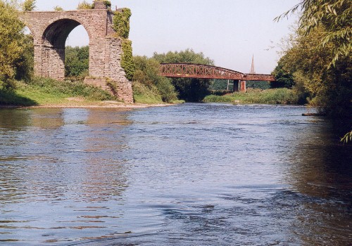
382:{{Information |Description =The River Wye in Monmouth with the two disused railway bridges in the foreground |Source =https://www.geograph.org.uk/photo/58273 |Date =8 July 2009 |Author =Ralph Rawlinson |Permission =Lic
974:{{BotMoveToCommons|en.wikipedia|year={{subst:CURRENTYEAR}}|month={{subst:CURRENTMONTHNAME}}|day={{subst:CURRENTDAY}}}} {{Information |Description={{en|The River Wye in Monmouth with the two disused railway bridges in the foreground}} |Source=Transferred
38:
326:– You must give appropriate credit, provide a link to the license, and indicate if changes were made. You may do so in any reasonable manner, but not in any way that suggests the licensor endorses you or your use.
198:
184:
967:
665:
583:
539:
681:
673:
448:
848:
784:
780:
677:
661:
535:
444:
440:
432:
685:
669:
623:
579:
436:
428:
689:
586:"}},"text\/plain":{"en":{"P275":"Creative Commons Attribution-ShareAlike 2.0 Generic"}}}}": -->
162:
692:"}},"text\/plain":{"en":{"P973":"https:\/\/www.geograph.org.uk\/photo\/58273"}}}}": -->
715:
609:
565:
208:
78:
735:
243:
46:
1003:
333:
520:
998:
858:
825:
798:
743:
699:
549:
513:
500:
485:
758:
728:
633:
593:
458:
417:
956:
951:
1021:
289:
332:– If you remix, transform, or build upon the material, you must distribute your contributions under the
250:
on the
Geograph website for the photographer's contact details. The copyright on this image is owned by
451:"}},"text\/plain":{"en":{"P3831":"photographer"}}}}": -->
988:
542:"}},"text\/plain":{"en":{"P6216":"copyrighted"}}}}": -->
791:"}},"text\/plain":{"en":{"P7787":"315 degree"}}}}": -->
86:
926:
921:
492:
286:
37:
765:
750:
8:
944:
Replace with original from
Geograph, which is identical apart from having less JPEG noise
369:
230:
993:
214:
255:
73:
407:
121:
The River Wye in
Monmouth with the two disused railway bridges in the foreground
377:
151:
141:
868:
808:
709:
643:
603:
559:
468:
235:
937:
247:
894:
Click on a date/time to view the file as it appeared at that time.
200:
185:
51° 48′ 13.05″ N, 2° 42′ 17.24″ W
1031:
130:
61:
401:
Add a one-line explanation of what this file represents
1041:
982:
1012:
892:
169:
Creative
Commons Attribution Share-alike license 2.0
85:
Commons is a freely licensed media file repository.
610:
Creative
Commons Attribution-ShareAlike 2.0 Generic
584:
Creative
Commons Attribution-ShareAlike 2.0 Generic
372:. All following user names refer to en.wikipedia.
51:(500 × 350 pixels, file size: 73 KB, MIME type:
343:https://creativecommons.org/licenses/by-sa/2.0
66:
349:Creative Commons Attribution-Share Alike 2.0
267:
157:
126:
108:
437:https:\/\/www.geograph.org.uk\/profile\/2091
147:
136:
14:
788:
690:https:\/\/www.geograph.org.uk\/photo\/58273
309:– to copy, distribute and transmit the work
1014:The following other wikis use this file:
493:https://www.geograph.org.uk/profile/2091
766:https://www.geograph.org.uk/photo/58273
1022:Železniční trať Monmouth – Ross-on-Wye
363:
207:View this and other nearby images on:
984:The following 4 pages use this file:
97:
1004:Portal:Trains/Anniversaries/August 4
254:and is licensed for reuse under the
175:
999:Knowledge:GLAM/MonmouthpediA/Images
885:
290:Attribution-Share Alike 2.0 Generic
278:
273:
258:Attribution-ShareAlike 2.0 license.
13:
406:
400:
368:The original description page was
367:
264:
241:
115:
98:
44:
1055:
405:
799:coordinates of the point of view
781:coordinates of the point of view
391:
320:Under the following conditions:
285:This file is licensed under the
277:
272:
266:
234:
213:
199:
191:
65:
31:
21:
969:File Upload Bot (Magnus Manske)
388:
116:
41:No higher resolution available.
1009:
889:
716:file available on the internet
666:file available on the internet
387:
242:This image was taken from the
26:
1:
814:51°48'13.054"N, 2°42'17.244"W
979:
736:Geograph Britain and Ireland
674:Geograph Britain and Ireland
514:object of statement has role
445:object of statement has role
413:Items portrayed in this file
226:
190:
7:
10:
1060:
1038:Usage on www.wikidata.org
1028:Usage on nl.wikipedia.org
1018:Usage on cs.wikipedia.org
334:same or compatible license
105:
100:
989:Ross and Monmouth Railway
886:
111:River Wye in Monmouth.jpg
47:River_Wye_in_Monmouth.jpg
16:
744:geograph.org.uk image ID
678:geograph.org.uk image ID
390:
300:
72:This is a file from the
36:
973:
943:
380:500×350× (41391 bytes)
129:
76:. Information from its
248:this photograph's page
219:51.803626; -2.704790
79:description page there
922:14:13, 12 June 2021
364:Original upload log
315:– to adapt the work
994:Wye Valley Railway
952:15:35, 8 July 2009
501:author name string
441:author name string
1010:Global file usage
977:
790:
594:copyright license
580:copyright license
399:
376:2009-07-08 15:20
263:
262:
246:collection. See
224:
223:
173:
172:
166:
163:Reusing this file
94:
93:
74:Wikimedia Commons
32:Global file usage
1051:
964:
934:
896:
836:
835:
830:
768:
763:
759:described at URL
753:
748:
738:
733:
686:described at URL
550:copyright status
536:copyright status
523:
518:
508:
505:
495:
490:
397:
356:
353:
350:
347:
344:
336:as the original.
298:
287:Creative Commons
281:
280:
276:
275:
270:
269:
256:Creative Commons
244:Geograph project
238:
231:
220:
217:
203:
202:
196:
195:
194:
188:
187:
176:
160:
132:
120:
112:
106:
90:
69:
68:
62:
56:
54:
1059:
1058:
1054:
1053:
1052:
1050:
1049:
1048:
1008:
978:
970:
962:
940:
932:
888:
887:
884:
883:
882:
881:
880:
879:
878:
877:
875:
865:
864:
863:
861:
846:
845:
844:
843:
842:
841:
840:
839:
838:
837:
833:
831:
828:
819:
818:
817:
815:
805:
804:
803:
801:
778:
777:
776:
775:
774:
773:
772:
771:
770:
769:
764:
761:
755:
754:
749:
746:
740:
739:
734:
731:
722:
721:
720:
718:
706:
705:
704:
702:
659:
658:
657:
656:
655:
654:
653:
652:
650:
640:
639:
638:
636:
621:
620:
619:
618:
617:
616:
615:
614:
612:
600:
599:
598:
596:
577:
576:
575:
574:
573:
572:
571:
570:
568:
556:
555:
554:
552:
533:
532:
531:
530:
529:
528:
527:
526:
525:
524:
519:
516:
510:
509:
507:Ralph Rawlinson
506:
503:
497:
496:
491:
488:
479:
478:
477:
475:
465:
464:
463:
461:
426:
425:
424:
423:
422:
420:
404:
403:
402:
373:
366:
358:
357:
354:
351:
348:
345:
342:
341:
299:
297:Ralph Rawlinson
296:
293:
282:
259:
252:Ralph Rawlinson
229:
218:
192:
183:
182:
179:Camera location
174:
152:Ralph Rawlinson
142:geograph.org.uk
122:
110:
103:
96:
95:
84:
83:
82:is shown below.
58:
52:
50:
43:
42:
12:
11:
5:
1057:
1047:
1046:
1045:
1044:
1036:
1035:
1034:
1026:
1025:
1024:
1011:
1007:
1006:
1001:
996:
991:
981:
976:
975:
972:
968:
965:
959:
954:
949:
946:
945:
942:
938:
935:
929:
924:
919:
915:
914:
911:
908:
905:
902:
899:
891:
876:
873:
871:
870:
869:
867:
866:
862:
857:
855:
854:
853:
852:
850:
824:
823:
822:
821:
820:
816:
813:
811:
810:
809:
807:
806:
802:
797:
795:
794:
793:
792:
786:
782:
757:
756:
742:
741:
727:
726:
725:
724:
723:
719:
714:
712:
711:
710:
708:
707:
703:
700:source of file
698:
696:
695:
694:
693:
691:
687:
683:
679:
675:
671:
667:
663:
662:source of file
651:
648:
646:
645:
644:
642:
641:
637:
632:
630:
629:
628:
627:
625:
613:
608:
606:
605:
604:
602:
601:
597:
592:
590:
589:
588:
587:
585:
581:
569:
564:
562:
561:
560:
558:
557:
553:
548:
546:
545:
544:
543:
541:
537:
512:
511:
499:
498:
484:
483:
482:
481:
480:
476:
473:
471:
470:
469:
467:
466:
462:
457:
455:
454:
453:
452:
450:
446:
442:
438:
434:
430:
421:
416:
414:
411:
410:
409:
408:
396:
395:
392:
389:
385:
384:
365:
362:
340:
339:
338:
337:
327:
318:
317:
316:
310:
303:You are free:
294:
284:
283:
265:
261:
260:
239:
228:
225:
222:
221:
211:
205:
180:
171:
170:
167:
155:
154:
149:
145:
144:
138:
134:
133:
128:
124:
123:
113:
104:
102:
99:
92:
91:
70:
60:
59:
40:
35:
34:
29:
24:
19:
9:
6:
4:
3:
2:
1056:
1043:
1040:
1039:
1037:
1033:
1030:
1029:
1027:
1023:
1020:
1019:
1017:
1016:
1015:
1005:
1002:
1000:
997:
995:
992:
990:
987:
986:
985:
971:
966:
960:
958:
955:
953:
950:
948:
947:
941:
936:
930:
928:
925:
923:
920:
917:
916:
912:
909:
906:
903:
900:
898:
897:
895:
872:
860:
856:
827:
812:
800:
796:
767:
760:
752:
745:
737:
730:
717:
713:
701:
697:
647:
635:
631:
611:
607:
595:
591:
567:
563:
551:
547:
522:
515:
502:
494:
487:
472:
460:
456:
419:
415:
412:
393:
386:
383:
379:
375:
374:
371:
361:
360:
346:CC BY-SA 2.0
335:
331:
328:
325:
322:
321:
319:
314:
311:
308:
305:
304:
302:
301:
295:Attribution:
291:
288:
271:
257:
253:
249:
245:
240:
237:
233:
232:
216:
212:
210:
209:OpenStreetMap
206:
204:
186:
181:
178:
177:
168:
164:
159:
156:
153:
150:
146:
143:
139:
135:
125:
119:
114:
107:
88:
81:
80:
75:
71:
64:
63:
57:
48:
39:
33:
30:
28:
25:
23:
20:
18:
15:
1032:Wye (rivier)
1013:
983:
893:
890:File history
521:photographer
449:photographer
381:
359:
329:
323:
312:
306:
251:
189:
117:
87:You can help
77:
45:
22:File history
649:8 July 2002
566:copyrighted
540:copyrighted
330:share alike
324:attribution
131:8 July 2002
109:Description
980:File usage
961:500 × 350
931:500 × 350
907:Dimensions
874:image/jpeg
859:media type
849:media type
474:some value
158:Permission
53:image/jpeg
27:File usage
904:Thumbnail
901:Date/Time
634:inception
624:inception
227:Licensing
118:English:
1042:Q7369737
729:operator
670:operator
394:Captions
313:to remix
307:to share
292:license.
963:(40 KB)
933:(73 KB)
918:current
913:Comment
826:heading
785:heading
459:creator
429:creator
418:depicts
398:English
101:Summary
49:
834:degree
789:degree
378:WVRMad
197:
148:Author
137:Source
939:Bjh21
751:58273
682:58273
140:From
910:User
832:315
370:here
355:true
352:true
127:Date
17:File
486:URL
433:URL
829::
762::
747::
732::
517::
504::
489::
165:)
161:(
89:.
55:)
