675:"}},"text\/plain":{"en":{"":"coordinates of the point of view"}}},"{\"value\":{\"latitude\":50.485849,\"longitude\":-4.027814,\"altitude\":null,\"precision\":1.0e-6,\"globe\":\"http:\\\/\\\/www.wikidata.org\\\/entity\\\/Q2\"},\"type\":\"globecoordinate\"}":{"text\/html":{"en":{"P1259":"50\u00b029'9.056"N, 4\u00b01'40.130"W"}},"text\/plain":{"en":{"P1259":"50\u00b029'9.056\"N, 4\u00b01'40.130\"W"}}},"{\"value\":{\"entity-type\":\"property\",\"numeric-id\":7787,\"id\":\"P7787\"},\"type\":\"wikibase-entityid\"}":{"text\/html":{"en":{"":"
743:"}},"text\/plain":{"en":{"":"inception"}}},"{\"value\":{\"time\":\"+2009-02-11T00:00:00Z\",\"timezone\":0,\"before\":0,\"after\":0,\"precision\":11,\"calendarmodel\":\"http:\\\/\\\/www.wikidata.org\\\/entity\\\/Q1985727\"},\"type\":\"time\"}":{"text\/html":{"en":{"P571":"11 February 2009"}},"text\/plain":{"en":{"P571":"11 February 2009"}}}}": -->
777:
476:
244:
671:
285:
323:
328:
67:
496:"}},"text\/plain":{"en":{"P2699":"https:\/\/www.geograph.org.uk\/profile\/19336"}}},"{\"value\":{\"entity-type\":\"property\",\"numeric-id\":2093,\"id\":\"P2093\"},\"type\":\"wikibase-entityid\"}":{"text\/html":{"en":{"":"
793:"}},"text\/plain":{"en":{"P973":"https:\/\/www.geograph.org.uk\/photo\/1157860"}}},"{\"value\":{\"entity-type\":\"property\",\"numeric-id\":7384,\"id\":\"P7384\"},\"type\":\"wikibase-entityid\"}":{"text\/html":{"en":{"":"
785:"}},"text\/plain":{"en":{"P7482":"file available on the internet"}}},"{\"value\":{\"entity-type\":\"property\",\"numeric-id\":973,\"id\":\"P973\"},\"type\":\"wikibase-entityid\"}":{"text\/html":{"en":{"":"
500:"}},"text\/plain":{"en":{"":"author name string"}}},"{\"value\":\"Guy Wareham\",\"type\":\"string\"}":{"text\/html":{"en":{"P2093":"Guy Wareham"}},"text\/plain":{"en":{"P2093":"Guy Wareham"}}}}": -->
484:"}},"text\/plain":{"en":{"":"object of statement has role"}}},"{\"value\":{\"entity-type\":\"item\",\"numeric-id\":33231,\"id\":\"Q33231\"},\"type\":\"wikibase-entityid\"}":{"text\/html":{"en":{"P3831":"
900:"}},"text\/plain":{"en":{"":"location of creation"}}},"{\"value\":{\"entity-type\":\"item\",\"numeric-id\":1957123,\"id\":\"Q1957123\"},\"type\":\"wikibase-entityid\"}":{"text\/html":{"en":{"P1071":"
631:"}},"text\/plain":{"en":{"":"copyright license"}}},"{\"value\":{\"entity-type\":\"item\",\"numeric-id\":19068220,\"id\":\"Q19068220\"},\"type\":\"wikibase-entityid\"}":{"text\/html":{"en":{"P275":"
587:"}},"text\/plain":{"en":{"":"copyright status"}}},"{\"value\":{\"entity-type\":\"item\",\"numeric-id\":50423863,\"id\":\"Q50423863\"},\"type\":\"wikibase-entityid\"}":{"text\/html":{"en":{"P6216":"
781:"}},"text\/plain":{"en":{"":"source of file"}}},"{\"value\":{\"entity-type\":\"item\",\"numeric-id\":74228490,\"id\":\"Q74228490\"},\"type\":\"wikibase-entityid\"}":{"text\/html":{"en":{"P7482":"
488:"}},"text\/plain":{"en":{"P3831":"photographer"}}},"{\"value\":{\"entity-type\":\"property\",\"numeric-id\":2699,\"id\":\"P2699\"},\"type\":\"wikibase-entityid\"}":{"text\/html":{"en":{"":"
433:"}},"text\/plain":{"en":{"":"depicts"}}},"{\"value\":{\"entity-type\":\"item\",\"numeric-id\":17527711,\"id\":\"Q17527711\"},\"type\":\"wikibase-entityid\"}":{"text\/html":{"en":{"P180":"
805:"}},"text\/plain":{"en":{"":"operator"}}},"{\"value\":{\"entity-type\":\"item\",\"numeric-id\":1503119,\"id\":\"Q1503119\"},\"type\":\"wikibase-entityid\"}":{"text\/html":{"en":{"P137":"
679:"}},"text\/plain":{"en":{"":"heading"}}},"{\"value\":{\"amount\":\"+337\",\"unit\":\"http:\\\/\\\/www.wikidata.org\\\/entity\\\/Q28390\"},\"type\":\"quantity\"}":{"text\/html":{"en":{"P7787":"337
801:"}},"text\/plain":{"en":{"P7384":"1157860"}}},"{\"value\":{\"entity-type\":\"property\",\"numeric-id\":137,\"id\":\"P137\"},\"type\":\"wikibase-entityid\"}":{"text\/html":{"en":{"":"
480:"}},"text\/plain":{"en":{"":"creator"}}},"{\"value\":{\"entity-type\":\"property\",\"numeric-id\":3831,\"id\":\"P3831\"},\"type\":\"wikibase-entityid\"}":{"text\/html":{"en":{"":"
896:
797:"}},"text\/plain":{"en":{"":"geograph.org.uk image ID"}}},"{\"value\":\"1157860\",\"type\":\"string\"}":{"text\/html":{"en":{"P7384":"
38:
375:– You must give appropriate credit, provide a link to the license, and indicate if changes were made. You may do so in any reasonable manner, but not in any way that suggests the licensor endorses you or your use.
249:
235:
798:
782:
632:
588:
434:
901:
806:
485:
897:
794:
778:
676:
672:
584:
497:
489:
481:
790:
493:
802:
786:
740:
628:
477:
430:
635:"}},"text\/plain":{"en":{"P275":"Creative Commons Attribution-ShareAlike 2.0 Generic"}}}}": -->
172:
832:
658:
614:
463:
259:
1017:
927:
882:
292:
382:
541:
911:
860:
816:
717:
690:
598:
564:
549:
534:
437:"}},"text\/plain":{"en":{"P180":"Church of St Leonard, Sheepstor"}}}}": -->
78:
875:
845:
750:
642:
507:
447:
809:"}},"text\/plain":{"en":{"P137":"Geograph Britain and Ireland"}}}}": -->
46:
338:
381:– If you remix, transform, or build upon the material, you must distribute your contributions under the
299:
on the
Geograph website for the photographer's contact details. The copyright on this image is owned by
105:
591:"}},"text\/plain":{"en":{"P6216":"copyrighted"}}}}": -->
110:
683:"}},"text\/plain":{"en":{"P7787":"337 degree"}}}}": -->
904:"}},"text\/plain":{"en":{"P1071":"Sheepstor"}}}}": -->
86:
204:
867:
852:
556:
335:
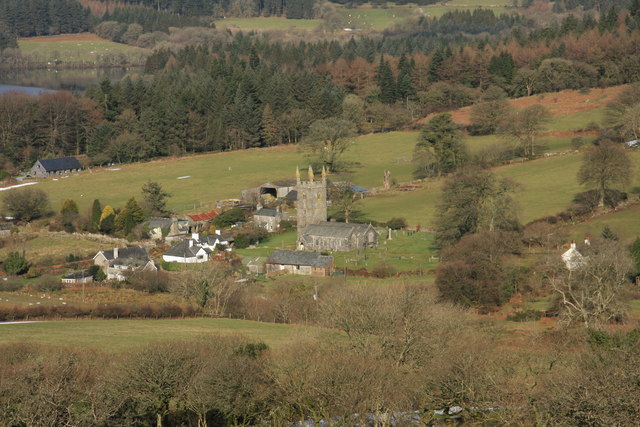
188:
8:
279:
1040:
981:
976:
265:
37:
1000:
992:
304:
73:
999:{{Information |Description={{en|1=gasdfgs}} |Source=Own work by uploader |Author=
161:
151:
1003:|Date= |Permission= |other_versions= }} <!--{{ImageUpload|full}}-->
921:
826:
760:
700:
652:
608:
517:
457:
284:
296:
1022:
949:
Click on a date/time to view the file as it appeared at that time.
251:
236:
50° 29′ 09.06″ N, 4° 01′ 40.13″ W
1050:
140:
61:
423:
Add a one-line explanation of what this file represents
1080:
1070:
1060:
1011:
1031:
947:
179:
Creative
Commons Attribution Share-alike license 2.0
85:
Commons is a freely licensed media file repository.
659:
Creative
Commons Attribution-ShareAlike 2.0 Generic
633:
Creative
Commons Attribution-ShareAlike 2.0 Generic
51:(640 × 427 pixels, file size: 86 KB, MIME type:
392:https://creativecommons.org/licenses/by-sa/2.0
66:
791:https:\/\/www.geograph.org.uk\/photo\/1157860
494:https:\/\/www.geograph.org.uk\/profile\/19336
398:Creative Commons Attribution-Share Alike 2.0
316:
167:
136:
125:
157:
146:
14:
680:
358:– to copy, distribute and transmit the work
1033:The following other wikis use this file:
853:https://www.geograph.org.uk/photo/1157860
557:https://www.geograph.org.uk/profile/19336
1018:Grade I listed buildings in West Devon
258:View this and other nearby images on:
1013:The following 2 pages use this file:
211:
97:
303:and is licensed for reuse under the
226:
940:
339:Attribution-Share Alike 2.0 Generic
327:
322:
307:Attribution-ShareAlike 2.0 license.
13:
428:
422:
313:
290:
103:
98:
44:
1094:
427:
691:coordinates of the point of view
673:coordinates of the point of view
413:
369:Under the following conditions:
334:This file is licensed under the
326:
321:
315:
283:
264:
250:
242:
65:
31:
21:
464:Church of St Leonard, Sheepstor
435:Church of St Leonard, Sheepstor
410:
41:No higher resolution available.
1047:Usage on nds-nl.wikipedia.org
1028:
944:
833:file available on the internet
783:file available on the internet
409:
291:This image was taken from the
26:
1:
1008:
883:Geograph Britain and Ireland
807:Geograph Britain and Ireland
535:object of statement has role
482:object of statement has role
443:Items portrayed in this file
241:
7:
706:50°29'9.056"N, 4°1'40.130"W
10:
1099:
1077:Usage on www.wikidata.org
1067:Usage on pl.wikipedia.org
1057:Usage on nl.wikipedia.org
1037:Usage on fa.wikipedia.org
383:same or compatible license
122:
99:
941:
16:
861:geograph.org.uk image ID
795:geograph.org.uk image ID
412:
349:
217:Guy Wareham /
198:Guy Wareham /
72:This is a file from the
36:
998:
189:required by the license
139:
76:. Information from its
297:this photograph's page
270:50.485849; -4.027814
79:description page there
128:Sheepstor village.jpg
47:Sheepstor_village.jpg
977:17:56, 21 March 2009
912:location of creation
898:location of creation
364:– to adapt the work
104:This is a photo of
565:author name string
498:author name string
1029:Global file usage
1006:
682:
643:copyright license
629:copyright license
421:
312:
311:
295:collection. See
275:
274:
224:
223:
192:
176:
173:Reusing this file
120:
119:
94:
93:
74:Wikimedia Commons
32:Global file usage
1090:
989:
951:
885:
880:
870:
865:
855:
850:
846:described at URL
787:described at URL
766:11 February 2009
728:
727:
722:
599:copyright status
585:copyright status
572:
569:
559:
554:
544:
539:
419:
405:
402:
399:
396:
393:
385:as the original.
347:
336:Creative Commons
330:
329:
325:
324:
319:
318:
305:Creative Commons
293:Geograph project
287:
280:
271:
268:
254:
253:
247:
246:
245:
239:
238:
227:
219:Sheepstor Church
200:Sheepstor Church
186:
170:
142:
141:11 February 2009
132:Sheepstor Church
129:
123:
113:
100:
90:
69:
68:
62:
56:
54:
1098:
1097:
1093:
1092:
1091:
1089:
1088:
1087:
1027:
1007:
995:
987:
943:
942:
939:
938:
937:
936:
935:
934:
933:
932:
930:
918:
917:
916:
914:
895:
894:
893:
892:
891:
890:
889:
888:
887:
886:
881:
878:
872:
871:
866:
863:
857:
856:
851:
848:
839:
838:
837:
835:
823:
822:
821:
819:
776:
775:
774:
773:
772:
771:
770:
769:
767:
757:
756:
755:
753:
738:
737:
736:
735:
734:
733:
732:
731:
730:
729:
725:
723:
720:
711:
710:
709:
707:
697:
696:
695:
693:
670:
669:
668:
667:
666:
665:
664:
663:
661:
649:
648:
647:
645:
626:
625:
624:
623:
622:
621:
620:
619:
617:
605:
604:
603:
601:
582:
581:
580:
579:
578:
577:
576:
575:
574:
573:
570:
567:
561:
560:
555:
552:
546:
545:
540:
537:
528:
527:
526:
524:
514:
513:
512:
510:
475:
474:
473:
472:
471:
470:
469:
468:
466:
454:
453:
452:
450:
426:
425:
424:
407:
406:
403:
400:
397:
394:
391:
390:
348:
345:
342:
331:
308:
269:
243:
234:
233:
230:Camera location
225:
214:
207:
195:
152:geograph.org.uk
127:
115:
109:
106:listed building
96:
95:
84:
83:
82:is shown below.
58:
52:
50:
43:
42:
12:
11:
5:
1096:
1086:
1085:
1084:
1083:
1075:
1074:
1073:
1065:
1064:
1063:
1055:
1054:
1053:
1045:
1044:
1043:
1030:
1026:
1025:
1020:
1010:
1005:
1004:
997:
993:
990:
984:
979:
974:
970:
969:
966:
963:
960:
957:
954:
946:
931:
926:
924:
923:
922:
920:
919:
915:
910:
908:
907:
906:
905:
903:
899:
874:
873:
859:
858:
844:
843:
842:
841:
840:
836:
831:
829:
828:
827:
825:
824:
820:
817:source of file
815:
813:
812:
811:
810:
808:
804:
800:
796:
792:
788:
784:
780:
779:source of file
768:
765:
763:
762:
761:
759:
758:
754:
749:
747:
746:
745:
744:
742:
716:
715:
714:
713:
712:
708:
705:
703:
702:
701:
699:
698:
694:
689:
687:
686:
685:
684:
678:
674:
662:
657:
655:
654:
653:
651:
650:
646:
641:
639:
638:
637:
636:
634:
630:
618:
613:
611:
610:
609:
607:
606:
602:
597:
595:
594:
593:
592:
590:
586:
563:
562:
548:
547:
533:
532:
531:
530:
529:
525:
522:
520:
519:
518:
516:
515:
511:
506:
504:
503:
502:
501:
499:
495:
491:
487:
483:
479:
467:
462:
460:
459:
458:
456:
455:
451:
446:
444:
441:
440:
439:
438:
436:
432:
418:
417:
414:
411:
389:
388:
387:
386:
376:
367:
366:
365:
359:
352:You are free:
343:
333:
332:
314:
310:
309:
288:
273:
272:
262:
256:
231:
222:
221:
215:
212:
209:
208:
203:
196:
193:
181:
180:
177:
165:
164:
159:
155:
154:
148:
144:
143:
138:
134:
133:
130:
121:
118:
117:
92:
91:
70:
60:
59:
40:
35:
34:
29:
24:
19:
9:
6:
4:
3:
2:
1095:
1082:
1079:
1078:
1076:
1072:
1069:
1068:
1066:
1062:
1059:
1058:
1056:
1052:
1049:
1048:
1046:
1042:
1039:
1038:
1036:
1035:
1034:
1024:
1021:
1019:
1016:
1015:
1014:
1002:
996:
991:
985:
983:
980:
978:
975:
972:
971:
967:
964:
961:
958:
955:
953:
952:
950:
929:
925:
913:
909:
884:
877:
869:
862:
854:
847:
834:
830:
818:
814:
764:
752:
748:
719:
704:
692:
688:
660:
656:
644:
640:
616:
612:
600:
596:
566:
558:
551:
543:
536:
521:
509:
505:
465:
461:
449:
445:
442:
415:
408:
395:CC BY-SA 2.0
384:
380:
377:
374:
371:
370:
368:
363:
360:
357:
354:
353:
351:
350:
344:Attribution:
340:
337:
320:
306:
302:
298:
294:
289:
286:
282:
281:
278:
277:
267:
263:
261:
260:OpenStreetMap
257:
255:
237:
232:
229:
228:
220:
216:
210:
206:
202: /
201:
197:
190:
185:
183:
182:
178:
174:
169:
166:
163:
160:
156:
153:
149:
145:
135:
131:
124:
116:
112:
107:
102:
101:
88:
81:
80:
75:
71:
64:
63:
57:
48:
39:
33:
30:
28:
25:
23:
20:
18:
15:
1032:
1012:
1001:Jolly Janner
994:Jolly Janner
948:
945:File history
542:photographer
486:photographer
378:
372:
361:
355:
300:
276:
240:
218:
205:CC BY-SA 2.0
199:
87:You can help
77:
45:
22:File history
615:copyrighted
589:copyrighted
571:Guy Wareham
379:share alike
373:attribution
346:Guy Wareham
301:Guy Wareham
184:Attribution
162:Guy Wareham
126:Description
1009:File usage
986:640 × 427
962:Dimensions
523:some value
168:Permission
53:image/jpeg
27:File usage
1081:Q17527711
1071:Sheepstor
1061:Sheepstor
1051:Sheepstor
1023:Sheepstor
959:Thumbnail
956:Date/Time
928:Sheepstor
902:Sheepstor
751:inception
741:inception
213:InfoField
194:InfoField
876:operator
803:operator
416:Captions
362:to remix
356:to share
341:license.
1041:شیپستور
988:(86 KB)
973:current
968:Comment
868:1157860
799:1157860
718:heading
677:heading
508:creator
478:creator
448:depicts
431:depicts
420:English
111:1171232
108:number
49:
726:degree
681:degree
248:
158:Author
147:Source
150:From
965:User
724:337
404:true
401:true
137:Date
17:File
550:URL
490:URL
879::
864::
849::
721::
568::
553::
538::
191:)
187:(
175:)
171:(
114:.
89:.
55:)
