669:"}},"text\/plain":{"en":{"":"coordinates of the point of view"}}},"{\"value\":{\"latitude\":52.710943,\"longitude\":-2.74893,\"altitude\":null,\"precision\":1.0e-6,\"globe\":\"http:\\\/\\\/www.wikidata.org\\\/entity\\\/Q2\"},\"type\":\"globecoordinate\"}":{"text\/html":{"en":{"P1259":"52\u00b042'39.395"N, 2\u00b044'56.148"W"}},"text\/plain":{"en":{"P1259":"52\u00b042'39.395\"N, 2\u00b044'56.148\"W"}}},"{\"value\":{\"entity-type\":\"property\",\"numeric-id\":7787,\"id\":\"P7787\"},\"type\":\"wikibase-entityid\"}":{"text\/html":{"en":{"":"
486:"}},"text\/plain":{"en":{"":"author name string"}}},"{\"value\":\"Ben Brooksbank\",\"type\":\"string\"}":{"text\/html":{"en":{"P2093":"Ben Brooksbank"}},"text\/plain":{"en":{"P2093":"Ben Brooksbank"}}},"{\"value\":{\"entity-type\":\"property\",\"numeric-id\":3831,\"id\":\"P3831\"},\"type\":\"wikibase-entityid\"}":{"text\/html":{"en":{"":"
856:"}},"text\/plain":{"en":{"":"inception"}}},"{\"value\":{\"time\":\"+1962-06-29T00:00:00Z\",\"timezone\":0,\"before\":0,\"after\":0,\"precision\":11,\"calendarmodel\":\"http:\\\/\\\/www.wikidata.org\\\/entity\\\/Q1985727\"},\"type\":\"time\"}":{"text\/html":{"en":{"P571":"29 June 1962"}},"text\/plain":{"en":{"P571":"29 June 1962"}}}}": -->
733:
271:
263:
665:
306:
344:
43:
349:
91:
482:"}},"text\/plain":{"en":{"P2699":"https:\/\/www.geograph.org.uk\/profile\/44502"}}},"{\"value\":{\"entity-type\":\"property\",\"numeric-id\":2093,\"id\":\"P2093\"},\"type\":\"wikibase-entityid\"}":{"text\/html":{"en":{"":"
757:"}},"text\/plain":{"en":{"P973":"https:\/\/www.geograph.org.uk\/photo\/2202736"}}},"{\"value\":{\"entity-type\":\"property\",\"numeric-id\":7384,\"id\":\"P7384\"},\"type\":\"wikibase-entityid\"}":{"text\/html":{"en":{"":"
741:"}},"text\/plain":{"en":{"P7482":"file available on the internet"}}},"{\"value\":{\"entity-type\":\"property\",\"numeric-id\":137,\"id\":\"P137\"},\"type\":\"wikibase-entityid\"}":{"text\/html":{"en":{"":"
490:"}},"text\/plain":{"en":{"":"object of statement has role"}}},"{\"value\":{\"entity-type\":\"item\",\"numeric-id\":33231,\"id\":\"Q33231\"},\"type\":\"wikibase-entityid\"}":{"text\/html":{"en":{"P3831":"
749:"}},"text\/plain":{"en":{"P137":"Geograph Britain and Ireland"}}},"{\"value\":{\"entity-type\":\"property\",\"numeric-id\":973,\"id\":\"P973\"},\"type\":\"wikibase-entityid\"}":{"text\/html":{"en":{"":"
625:"}},"text\/plain":{"en":{"":"copyright license"}}},"{\"value\":{\"entity-type\":\"item\",\"numeric-id\":19068220,\"id\":\"Q19068220\"},\"type\":\"wikibase-entityid\"}":{"text\/html":{"en":{"P275":"
581:"}},"text\/plain":{"en":{"":"copyright status"}}},"{\"value\":{\"entity-type\":\"item\",\"numeric-id\":50423863,\"id\":\"Q50423863\"},\"type\":\"wikibase-entityid\"}":{"text\/html":{"en":{"P6216":"
737:"}},"text\/plain":{"en":{"":"source of file"}}},"{\"value\":{\"entity-type\":\"item\",\"numeric-id\":74228490,\"id\":\"Q74228490\"},\"type\":\"wikibase-entityid\"}":{"text\/html":{"en":{"P7482":"
745:"}},"text\/plain":{"en":{"":"operator"}}},"{\"value\":{\"entity-type\":\"item\",\"numeric-id\":1503119,\"id\":\"Q1503119\"},\"type\":\"wikibase-entityid\"}":{"text\/html":{"en":{"P137":"
673:"}},"text\/plain":{"en":{"":"heading"}}},"{\"value\":{\"amount\":\"+337\",\"unit\":\"http:\\\/\\\/www.wikidata.org\\\/entity\\\/Q28390\"},\"type\":\"quantity\"}":{"text\/html":{"en":{"P7787":"337
474:"}},"text\/plain":{"en":{"":"creator"}}},"{\"value\":{\"entity-type\":\"property\",\"numeric-id\":2699,\"id\":\"P2699\"},\"type\":\"wikibase-entityid\"}":{"text\/html":{"en":{"":"
932:
577:
396:– You must give appropriate credit, provide a link to the license, and indicate if changes were made. You may do so in any reasonable manner, but not in any way that suggests the licensor endorses you or your use.
268:
57:
53:
47:
762:
738:
626:
582:
102:
746:
70:
491:
758:
734:
670:
666:
578:
487:
483:
475:
754:
479:
853:
750:
742:
622:
471:
629:"}},"text\/plain":{"en":{"P275":"Creative Commons Attribution-ShareAlike 2.0 Generic"}}}}": -->
191:
788:
652:
608:
278:
808:
313:
994:
This file contains additional information, probably added from the digital camera or scanner used to create or digitize it.
1030:
403:
563:
831:
772:
711:
684:
592:
556:
543:
528:
863:
816:
801:
636:
501:
460:
931:
926:
61:
42:
359:
997:
If the file has been modified from its original state, some details may not fully reflect the modified file.
402:– If you remix, transform, or build upon the material, you must distribute your contributions under the
320:
on the
Geograph website for the photographer's contact details. The copyright on this image is owned by
963:
494:"}},"text\/plain":{"en":{"P3831":"photographer"}}}}": -->
585:"}},"text\/plain":{"en":{"P6216":"copyrighted"}}}}": -->
677:"}},"text\/plain":{"en":{"P7787":"337 degree"}}}}": -->
765:"}},"text\/plain":{"en":{"P7384":"2202736"}}}}": -->
110:
223:
838:
823:
535:
356:
207:
8:
300:
284:
325:
97:
450:
981:
180:
170:
873:
782:
694:
646:
602:
511:
1045:
942:
305:
317:
899:
Click on a date/time to view the file as it appeared at that time.
270:
255:
52° 42′ 39.39″ N, 2° 44′ 56.15″ W
159:
85:
444:
Add a one-line explanation of what this file represents
957:
972:
897:
198:
Creative
Commons Attribution Share-alike license 2.0
109:
Commons is a freely licensed media file repository.
653:
Creative
Commons Attribution-ShareAlike 2.0 Generic
627:
Creative
Commons Attribution-ShareAlike 2.0 Generic
75:(1,024 × 596 pixels, file size: 276 KB, MIME type:
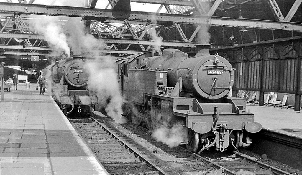
135:Shrewsbury 2 railway station geograph-2202736.jpg
413:https://creativecommons.org/licenses/by-sa/2.0
90:
755:https:\/\/www.geograph.org.uk\/photo\/2202736
480:https:\/\/www.geograph.org.uk\/profile\/44502
419:Creative Commons Attribution-Share Alike 2.0
337:
186:
155:
132:
176:
165:
14:
674:
379:– to copy, distribute and transmit the work
146:Shrewsbury Station, south end with trains.
974:The following other wikis use this file:
824:https://www.geograph.org.uk/photo/2202736
536:https://www.geograph.org.uk/profile/44502
238:Shrewsbury Station, south end with trains
219:Shrewsbury Station, south end with trains
982:Ferrocarril de Shrewsbury y Birmingham
277:View this and other nearby images on:
230:
121:
1031:Adobe Photoshop Elements 3.0 Windows
324:and is licensed for reuse under the
245:
959:The following page uses this file:
890:
360:Attribution-Share Alike 2.0 Generic
348:
343:
328:Attribution-ShareAlike 2.0 license.
13:
992:
449:
443:
334:
311:
139:
122:
68:
1062:
999:
448:
685:coordinates of the point of view
667:coordinates of the point of view
434:
390:Under the following conditions:
355:This file is licensed under the
347:
342:
336:
304:
283:
269:
261:
89:
31:
21:
431:
140:
969:
894:
789:file available on the internet
739:file available on the internet
430:
312:This image was taken from the
26:
1:
700:52°42'39.395"N, 2°44'56.148"W
36:
954:
809:Geograph Britain and Ireland
747:Geograph Britain and Ireland
557:object of statement has role
488:object of statement has role
456:Items portrayed in this file
296:
260:
7:
989:
236:Ben Brooksbank /
217:Ben Brooksbank /
10:
1067:
978:Usage on es.wikipedia.org
964:Shrewsbury railway station
404:same or compatible license
129:
124:
1037:File change date and time
891:
16:
832:geograph.org.uk image ID
759:geograph.org.uk image ID
433:
370:
96:This is a file from the
41:
1040:23:25, 19 December 2010
948:
927:12:05, 22 December 2010
208:required by the license
158:
100:. Information from its
318:this photograph's page
289:52.710943; -2.748930
103:description page there
46:Size of this preview:
1011:Horizontal resolution
1019:Vertical resolution
385:– to adapt the work
52:Other resolutions:
544:author name string
484:author name string
62:1,024 × 596 pixels
1054:
1053:
970:Global file usage
952:
676:
637:copyright license
623:copyright license
442:
333:
332:
316:collection. See
294:
293:
243:
242:
211:
195:
192:Reusing this file
118:
117:
98:Wikimedia Commons
32:Global file usage
1058:
1000:
939:
901:
841:
836:
826:
821:
817:described at URL
811:
806:
751:described at URL
722:
721:
716:
593:copyright status
579:copyright status
566:
561:
551:
548:
538:
533:
440:
426:
423:
420:
417:
414:
406:as the original.
368:
357:Creative Commons
351:
350:
346:
345:
340:
339:
326:Creative Commons
314:Geograph project
308:
301:
290:
287:
273:
272:
266:
265:
264:
258:
257:
246:
205:
189:
161:
144:
136:
130:
114:
93:
92:
86:
80:
78:
65:
58:640 × 373 pixels
54:320 × 186 pixels
48:800 × 466 pixels
1066:
1065:
1061:
1060:
1059:
1057:
1056:
1055:
988:
968:
953:
945:
937:
893:
892:
889:
888:
887:
886:
885:
884:
883:
882:
880:
870:
869:
868:
866:
851:
850:
849:
848:
847:
846:
845:
844:
843:
842:
837:
834:
828:
827:
822:
819:
813:
812:
807:
804:
795:
794:
793:
791:
779:
778:
777:
775:
732:
731:
730:
729:
728:
727:
726:
725:
724:
723:
719:
717:
714:
705:
704:
703:
701:
691:
690:
689:
687:
664:
663:
662:
661:
660:
659:
658:
657:
655:
643:
642:
641:
639:
620:
619:
618:
617:
616:
615:
614:
613:
611:
599:
598:
597:
595:
576:
575:
574:
573:
572:
571:
570:
569:
568:
567:
562:
559:
553:
552:
549:
546:
540:
539:
534:
531:
522:
521:
520:
518:
508:
507:
506:
504:
469:
468:
467:
466:
465:
463:
447:
446:
445:
428:
427:
424:
421:
418:
415:
412:
411:
369:
366:
363:
352:
329:
299:
288:
262:
253:
252:
249:Camera location
244:
233:
226:
214:
171:geograph.org.uk
151:
134:
127:
120:
119:
108:
107:
106:is shown below.
82:
76:
74:
67:
66:
51:
12:
11:
5:
1064:
1052:
1051:
1048:
1042:
1041:
1038:
1034:
1033:
1028:
1024:
1023:
1020:
1016:
1015:
1012:
1008:
1007:
1004:
991:
987:
986:
985:
984:
971:
967:
966:
956:
951:
950:
947:
943:
940:
934:
929:
924:
920:
919:
916:
913:
910:
907:
904:
896:
881:
878:
876:
875:
874:
872:
871:
867:
862:
860:
859:
858:
857:
855:
830:
829:
815:
814:
800:
799:
798:
797:
796:
792:
787:
785:
784:
783:
781:
780:
776:
773:source of file
771:
769:
768:
767:
766:
764:
760:
756:
752:
748:
744:
740:
736:
735:source of file
710:
709:
708:
707:
706:
702:
699:
697:
696:
695:
693:
692:
688:
683:
681:
680:
679:
678:
672:
668:
656:
651:
649:
648:
647:
645:
644:
640:
635:
633:
632:
631:
630:
628:
624:
612:
607:
605:
604:
603:
601:
600:
596:
591:
589:
588:
587:
586:
584:
580:
555:
554:
550:Ben Brooksbank
542:
541:
527:
526:
525:
524:
523:
519:
516:
514:
513:
512:
510:
509:
505:
500:
498:
497:
496:
495:
493:
489:
485:
481:
477:
473:
464:
459:
457:
454:
453:
452:
451:
439:
438:
435:
432:
410:
409:
408:
407:
397:
388:
387:
386:
380:
373:You are free:
367:Ben Brooksbank
364:
354:
353:
335:
331:
330:
322:Ben Brooksbank
309:
298:
295:
292:
291:
281:
275:
250:
241:
240:
234:
231:
228:
227:
222:
215:
212:
200:
199:
196:
184:
183:
181:Ben Brooksbank
178:
174:
173:
167:
163:
162:
157:
153:
152:
137:
128:
126:
123:
116:
115:
94:
84:
83:
45:
40:
39:
34:
29:
24:
19:
9:
6:
4:
3:
2:
1063:
1049:
1047:
1044:
1043:
1039:
1036:
1035:
1032:
1029:
1027:Software used
1026:
1025:
1021:
1018:
1017:
1013:
1010:
1009:
1005:
1002:
1001:
998:
995:
983:
980:
979:
977:
976:
975:
965:
962:
961:
960:
946:
941:
935:
933:
930:
928:
925:
922:
921:
917:
914:
911:
908:
905:
903:
902:
900:
877:
865:
861:
840:
833:
825:
818:
810:
803:
790:
786:
774:
770:
713:
698:
686:
682:
654:
650:
638:
634:
610:
606:
594:
590:
565:
558:
545:
537:
530:
515:
503:
499:
462:
458:
455:
436:
429:
416:CC BY-SA 2.0
405:
401:
398:
395:
392:
391:
389:
384:
381:
378:
375:
374:
372:
371:
365:Attribution:
361:
358:
341:
327:
323:
319:
315:
310:
307:
303:
302:
286:
282:
280:
279:OpenStreetMap
276:
274:
256:
251:
248:
247:
239:
235:
229:
225:
221: /
220:
216:
209:
204:
202:
201:
197:
193:
188:
185:
182:
179:
175:
172:
168:
164:
154:
148:
147:
143:
138:
131:
112:
105:
104:
99:
95:
88:
87:
81:
72:
71:Original file
63:
59:
55:
49:
44:
38:
35:
33:
30:
28:
25:
23:
20:
18:
15:
1050:Uncalibrated
996:
993:
973:
958:
936:1,024 × 596
898:
895:File history
879:29 June 1962
564:photographer
492:photographer
399:
393:
382:
376:
321:
259:
237:
224:CC BY-SA 2.0
218:
160:29 June 1962
145:
141:
111:You can help
101:
69:
22:File history
1046:Color space
1003:Orientation
609:copyrighted
583:copyrighted
400:share alike
394:attribution
203:Attribution
133:Description
955:File usage
912:Dimensions
517:some value
187:Permission
77:image/jpeg
27:File usage
909:Thumbnail
906:Date/Time
864:inception
854:inception
297:Licensing
232:InfoField
213:InfoField
142:English:
990:Metadata
938:(276 KB)
802:operator
743:operator
437:Captions
383:to remix
377:to share
362:license.
37:Metadata
923:current
918:Comment
839:2202736
763:2202736
712:heading
671:heading
502:creator
472:creator
461:depicts
441:English
125:Summary
73:
1022:78 dpc
1014:78 dpc
1006:Normal
944:Chevin
720:degree
675:degree
267:
177:Author
166:Source
169:From
915:User
718:337
425:true
422:true
156:Date
17:File
529:URL
476:URL
835::
820::
805::
715::
560::
547::
532::
60:|
56:|
50:.
210:)
206:(
194:)
190:(
113:.
79:)
64:.
Text is available under the Creative Commons Attribution-ShareAlike License. Additional terms may apply.
