836:"}},"text\/plain":{"en":{"":"coordinates of the point of view"}}},"{\"value\":{\"latitude\":51.8596,\"longitude\":-0.437,\"altitude\":null,\"precision\":0.0001,\"globe\":\"http:\\\/\\\/www.wikidata.org\\\/entity\\\/Q2\"},\"type\":\"globecoordinate\"}":{"text\/html":{"en":{"P1259":"51\u00b051'34.6"N, 0\u00b026'13.2"W"}},"text\/plain":{"en":{"P1259":"51\u00b051'34.6\"N, 0\u00b026'13.2\"W"}}},"{\"value\":{\"entity-type\":\"property\",\"numeric-id\":7787,\"id\":\"P7787\"},\"type\":\"wikibase-entityid\"}":{"text\/html":{"en":{"":"
948:"}},"text\/plain":{"en":{"":"coordinates of depicted place"}}},"{\"value\":{\"latitude\":51.8597,\"longitude\":-0.438,\"altitude\":null,\"precision\":0.0001,\"globe\":\"http:\\\/\\\/www.wikidata.org\\\/entity\\\/Q2\"},\"type\":\"globecoordinate\"}":{"text\/html":{"en":{"P9149":"51\u00b051'34.9"N, 0\u00b026'16.8"W"}},"text\/plain":{"en":{"P9149":"51\u00b051'34.9\"N, 0\u00b026'16.8\"W"}}},"{\"value\":{\"entity-type\":\"property\",\"numeric-id\":7787,\"id\":\"P7787\"},\"type\":\"wikibase-entityid\"}":{"text\/html":{"en":{"":"
496:"}},"text\/plain":{"en":{"":"author name string"}}},"{\"value\":\"Nigel Cox\",\"type\":\"string\"}":{"text\/html":{"en":{"P2093":"Nigel Cox"}},"text\/plain":{"en":{"P2093":"Nigel Cox"}}},"{\"value\":{\"entity-type\":\"property\",\"numeric-id\":3831,\"id\":\"P3831\"},\"type\":\"wikibase-entityid\"}":{"text\/html":{"en":{"":"
679:"}},"text\/plain":{"en":{"":"inception"}}},"{\"value\":{\"time\":\"+2006-05-13T00:00:00Z\",\"timezone\":0,\"before\":0,\"after\":0,\"precision\":11,\"calendarmodel\":\"http:\\\/\\\/www.wikidata.org\\\/entity\\\/Q1985727\"},\"type\":\"time\"}":{"text\/html":{"en":{"P571":"13 May 2006"}},"text\/plain":{"en":{"P571":"13 May 2006"}}}}": -->
713:
480:
231:
273:
223:
944:
245:
316:
354:
359:
72:
1061:"}},"text\/plain":{"en":{"":"f-number"}}},"{\"value\":{\"amount\":\"+5.6\",\"unit\":\"1\"},\"type\":\"quantity\"}":{"text\/html":{"en":{"P6790":"5.6"}},"text\/plain":{"en":{"P6790":"5.6"}}}}": -->
492:"}},"text\/plain":{"en":{"P2699":"https:\/\/www.geograph.org.uk\/profile\/2798"}}},"{\"value\":{\"entity-type\":\"property\",\"numeric-id\":2093,\"id\":\"P2093\"},\"type\":\"wikibase-entityid\"}":{"text\/html":{"en":{"":"
1220:
721:"}},"text\/plain":{"en":{"P7482":"file available on the internet"}}},"{\"value\":{\"entity-type\":\"property\",\"numeric-id\":137,\"id\":\"P137\"},\"type\":\"wikibase-entityid\"}":{"text\/html":{"en":{"":"
729:"}},"text\/plain":{"en":{"P137":"Geograph Britain and Ireland"}}},"{\"value\":{\"entity-type\":\"property\",\"numeric-id\":7384,\"id\":\"P7384\"},\"type\":\"wikibase-entityid\"}":{"text\/html":{"en":{"":"
500:"}},"text\/plain":{"en":{"":"object of statement has role"}}},"{\"value\":{\"entity-type\":\"item\",\"numeric-id\":33231,\"id\":\"Q33231\"},\"type\":\"wikibase-entityid\"}":{"text\/html":{"en":{"P3831":"
1144:"}},"text\/plain":{"en":{"":"media type"}}},"{\"value\":\"image\\\/jpeg\",\"type\":\"string\"}":{"text\/html":{"en":{"P1163":"image\/jpeg"}},"text\/plain":{"en":{"P1163":"image\/jpeg"}}}}": -->
635:"}},"text\/plain":{"en":{"":"copyright license"}}},"{\"value\":{\"entity-type\":\"item\",\"numeric-id\":19068220,\"id\":\"Q19068220\"},\"type\":\"wikibase-entityid\"}":{"text\/html":{"en":{"P275":"
591:"}},"text\/plain":{"en":{"":"copyright status"}}},"{\"value\":{\"entity-type\":\"item\",\"numeric-id\":50423863,\"id\":\"Q50423863\"},\"type\":\"wikibase-entityid\"}":{"text\/html":{"en":{"P6216":"
1016:"}},"text\/plain":{"en":{"":"exposure time"}}},"{\"value\":{\"amount\":\"+0.005\",\"unit\":\"http:\\\/\\\/www.wikidata.org\\\/entity\\\/Q11574\"},\"type\":\"quantity\"}":{"text\/html":{"en":{"P6757":"0.005
717:"}},"text\/plain":{"en":{"":"source of file"}}},"{\"value\":{\"entity-type\":\"item\",\"numeric-id\":74228490,\"id\":\"Q74228490\"},\"type\":\"wikibase-entityid\"}":{"text\/html":{"en":{"P7482":"
904:"}},"text\/plain":{"en":{"":"captured with"}}},"{\"value\":{\"entity-type\":\"item\",\"numeric-id\":20888971,\"id\":\"Q20888971\"},\"type\":\"wikibase-entityid\"}":{"text\/html":{"en":{"P4082":"
1099:"}},"text\/plain":{"en":{"":"focal length"}}},"{\"value\":{\"amount\":\"+5.8\",\"unit\":\"http:\\\/\\\/www.wikidata.org\\\/entity\\\/Q174789\"},\"type\":\"quantity\"}":{"text\/html":{"en":{"P2151":"5.8
952:"}},"text\/plain":{"en":{"":"heading"}}},"{\"value\":{\"amount\":\"+247\",\"unit\":\"http:\\\/\\\/www.wikidata.org\\\/entity\\\/Q28390\"},\"type\":\"quantity\"}":{"text\/html":{"en":{"P7787":"247
840:"}},"text\/plain":{"en":{"":"heading"}}},"{\"value\":{\"amount\":\"+247\",\"unit\":\"http:\\\/\\\/www.wikidata.org\\\/entity\\\/Q28390\"},\"type\":\"quantity\"}":{"text\/html":{"en":{"P7787":"247
725:"}},"text\/plain":{"en":{"":"operator"}}},"{\"value\":{\"entity-type\":\"item\",\"numeric-id\":1503119,\"id\":\"Q1503119\"},\"type\":\"wikibase-entityid\"}":{"text\/html":{"en":{"P137":"
737:"}},"text\/plain":{"en":{"P7384":"168764"}}},"{\"value\":{\"entity-type\":\"property\",\"numeric-id\":973,\"id\":\"P973\"},\"type\":\"wikibase-entityid\"}":{"text\/html":{"en":{"":"
484:"}},"text\/plain":{"en":{"":"creator"}}},"{\"value\":{\"entity-type\":\"property\",\"numeric-id\":2699,\"id\":\"P2699\"},\"type\":\"wikibase-entityid\"}":{"text\/html":{"en":{"":"
1140:
488:"}},"text\/plain":{"en":{"":"URL"}}},"{\"value\":\"https:\\\/\\\/www.geograph.org.uk\\\/profile\\\/2798\",\"type\":\"string\"}":{"text\/html":{"en":{"P2699":"
264:
733:"}},"text\/plain":{"en":{"":"geograph.org.uk image ID"}}},"{\"value\":\"168764\",\"type\":\"string\"}":{"text\/html":{"en":{"P7384":"
214:
1237:== {{int:filedesc}} == {{Information |description={{en|1=Slip End: The Plough, Woodside. The cream painted building is the former Baptist Chapel, now a private residence. }} |date=2006-05-13 |source=From [http://www.geograph.org.uk/photo/168764 geograph.o
406:– You must give appropriate credit, provide a link to the license, and indicate if changes were made. You may do so in any reasonable manner, but not in any way that suggests the licensor endorses you or your use.
51:
83:
278:
228:
905:
734:
718:
636:
592:
726:
501:
1141:
1096:
1058:
1013:
949:
945:
901:
837:
833:
730:
714:
588:
497:
493:
485:
742:
738:
722:
676:
632:
489:
481:
1230:
1269:
1299:
639:"}},"text\/plain":{"en":{"P275":"Creative Commons Attribution-ShareAlike 2.0 Generic"}}}}": -->
745:"}},"text\/plain":{"en":{"P973":"https:\/\/www.geograph.org.uk\/photo\/168764"}}}}": -->
1219:
1214:
42:
931:
768:
662:
618:
288:
238:
788:
323:
1342:
This file contains additional information, probably added from the digital camera or scanner used to create or digitize it.
413:
573:
1151:
1110:
1068:
1027:
990:
963:
915:
878:
851:
796:
752:
602:
566:
553:
538:
811:
781:
686:
646:
511:
470:
126:
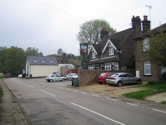
Slip End: The Plough, Woodside. The cream painted building is the former
Baptist Chapel, now a private residence.
1450:
908:"}},"text\/plain":{"en":{"P4082":"Canon Digital IXUS 40"}}}}": -->
369:
1345:
If the file has been modified from its original state, some details may not fully reflect the modified file.
1103:"}},"text\/plain":{"en":{"P2151":"5.8 millimetre"}}}}": -->
412:– If you remix, transform, or build upon the material, you must distribute your contributions under the
330:
on the
Geograph website for the photographer's contact details. The copyright on this image is owned by
1020:"}},"text\/plain":{"en":{"P6757":"0.005 second"}}}}": -->
504:"}},"text\/plain":{"en":{"P3831":"photographer"}}}}": -->
595:"}},"text\/plain":{"en":{"P6216":"copyrighted"}}}}": -->
956:"}},"text\/plain":{"en":{"P7787":"247 degree"}}}}": -->
844:"}},"text\/plain":{"en":{"P7787":"247 degree"}}}}": -->
91:
183:
1251:
1495:
1364:
818:
803:
545:
366:
167:
8:
1523:
310:
294:
244:
335:
78:
460:
1279:
1354:
1591:
1513:
1477:
1371:
1601:
1400:
156:
146:
1533:
1161:
1120:
1078:
1037:
973:
925:
861:
762:
696:
656:
612:
521:
315:
327:
1319:
1309:
1289:
1381:
1187:
Click on a date/time to view the file as it appeared at that time.
280:
230:
116:
Slip End, The Plough, Woodside - geograph.org.uk - 168764.jpg
52:
Slip_End,_The_Plough,_Woodside_-_geograph.org.uk_-_168764.jpg
265:
51° 51′ 35″ N, 0° 26′ 17″ W
215:
51° 51′ 35″ N, 0° 26′ 13″ W
135:
66:
454:
Add a one-line explanation of what this file represents
1329:
1245:
1260:
1185:
90:
Commons is a freely licensed media file repository.
663:
Creative
Commons Attribution-ShareAlike 2.0 Generic
637:
Creative
Commons Attribution-ShareAlike 2.0 Generic
56:(640 × 480 pixels, file size: 77 KB, MIME type:
423:https://creativecommons.org/licenses/by-sa/2.0
71:
429:Creative Commons Attribution-Share Alike 2.0
347:
131:
113:
743:https:\/\/www.geograph.org.uk\/photo\/168764
490:https:\/\/www.geograph.org.uk\/profile\/2798
152:
141:
14:
1100:
1017:
953:
841:
389:– to copy, distribute and transmit the work
1262:The following other wikis use this file:
819:https://www.geograph.org.uk/photo/168764
546:https://www.geograph.org.uk/profile/2798
287:View this and other nearby images on:
237:View this and other nearby images on:
190:
102:
334:and is licensed for reuse under the
255:
205:
1247:The following page uses this file:
1178:
370:Attribution-Share Alike 2.0 Generic
358:
353:
338:Attribution-ShareAlike 2.0 license.
13:
1340:
459:
453:
344:
321:
120:
103:
49:
1627:
1347:
458:
1391:Date and time of data generation
852:coordinates of the point of view
834:coordinates of the point of view
444:
400:Under the following conditions:
365:This file is licensed under the
357:
352:
346:
314:
293:
279:
271:
243:
229:
221:
70:
31:
21:
441:
121:
46:No higher resolution available.
1257:
1182:
769:file available on the internet
719:file available on the internet
440:
322:This image was taken from the
198:Slip End: The Plough, Woodside
179:Slip End: The Plough, Woodside
26:
1:
1528:Flash did not fire, auto mode
964:coordinates of depicted place
946:coordinates of depicted place
36:
1242:
789:Geograph Britain and Ireland
727:Geograph Britain and Ireland
567:object of statement has role
498:object of statement has role
466:Items portrayed in this file
306:
270:
220:
7:
1559:Focal plane resolution unit
1461:Date and time of digitizing
1337:
1276:Usage on arz.wikipedia.org
10:
1632:
1570:One-chip color area sensor
1326:Usage on www.wikidata.org
1316:Usage on pl.wikipedia.org
1306:Usage on fr.wikipedia.org
1296:Usage on fa.wikipedia.org
1286:Usage on cy.wikipedia.org
1266:Usage on ar.wikipedia.org
414:same or compatible license
110:
105:
1434:File change date and time
1179:
979:51°51'34.9"N, 0°26'16.8"W
867:51°51'34.6"N, 0°26'13.2"W
16:
1551:Focal plane Y resolution
1543:Focal plane X resolution
797:geograph.org.uk image ID
731:geograph.org.uk image ID
443:
380:
77:This is a file from the
41:
1575:Custom image processing
1320:Woodside (Bedfordshire)
1310:Woodside (Bedfordshire)
1290:Woodside, Swydd Bedford
1236:
168:required by the license
134:
81:. Information from its
1469:Image compression mode
1252:Woodside, Bedfordshire
1215:12:16, 31 January 2010
328:this photograph's page
299:51.859700; -0.438000
249:51.859600; -0.437000
196:Nigel Cox /
177:Nigel Cox /
84:description page there
1505:Maximum land aperture
1418:Horizontal resolution
1365:Canon DIGITAL IXUS 40
932:Canon Digital IXUS 40
906:Canon Digital IXUS 40
1508:2.96875 APEX (f/2.8)
1442:Y and C positioning
1426:Vertical resolution
1351:Camera manufacturer
1270:وودسيد (بيدفوردشير)
395:– to adapt the work
1612:Scene capture type
1596:Auto white balance
1464:09:39, 13 May 2006
1437:09:39, 13 May 2006
1394:09:39, 13 May 2006
554:author name string
494:author name string
1619:
1618:
1376:1/200 sec (0.005)
1300:وودساید، بدفوردشر
1258:Global file usage
1240:
1102:
1019:
955:
843:
647:copyright license
633:copyright license
452:
343:
342:
326:collection. See
304:
303:
254:
253:
203:
202:
171:
99:
98:
79:Wikimedia Commons
32:Global file usage
1623:
1554:10,142.857142857
1546:10,142.857142857
1348:
1227:
1189:
1129:
1046:
1001:
1000:
995:
889:
888:
883:
821:
816:
812:described at URL
806:
801:
791:
786:
739:described at URL
603:copyright status
589:copyright status
576:
571:
561:
558:
548:
543:
450:
436:
433:
430:
427:
424:
416:as the original.
378:
367:Creative Commons
361:
360:
356:
355:
350:
349:
336:Creative Commons
324:Geograph project
318:
311:
300:
297:
283:
282:
276:
275:
274:
268:
267:
256:
250:
247:
233:
232:
226:
225:
224:
218:
217:
206:
165:
137:
125:
117:
111:
95:
74:
73:
67:
61:
59:
1631:
1630:
1626:
1625:
1624:
1622:
1621:
1620:
1336:
1256:
1241:
1233:
1225:
1181:
1180:
1177:
1176:
1175:
1174:
1173:
1172:
1171:
1170:
1168:
1158:
1157:
1156:
1154:
1139:
1138:
1137:
1136:
1135:
1134:
1133:
1132:
1130:
1127:
1117:
1116:
1115:
1113:
1094:
1093:
1092:
1091:
1090:
1089:
1088:
1087:
1085:
1075:
1074:
1073:
1071:
1056:
1055:
1054:
1053:
1052:
1051:
1050:
1049:
1047:
1044:
1034:
1033:
1032:
1030:
1011:
1010:
1009:
1008:
1007:
1006:
1005:
1004:
1003:
1002:
998:
996:
993:
984:
983:
982:
980:
970:
969:
968:
966:
943:
942:
941:
940:
939:
938:
937:
936:
934:
922:
921:
920:
918:
899:
898:
897:
896:
895:
894:
893:
892:
891:
890:
886:
884:
881:
872:
871:
870:
868:
858:
857:
856:
854:
831:
830:
829:
828:
827:
826:
825:
824:
823:
822:
817:
814:
808:
807:
802:
799:
793:
792:
787:
784:
775:
774:
773:
771:
759:
758:
757:
755:
712:
711:
710:
709:
708:
707:
706:
705:
703:
693:
692:
691:
689:
674:
673:
672:
671:
670:
669:
668:
667:
665:
653:
652:
651:
649:
630:
629:
628:
627:
626:
625:
624:
623:
621:
609:
608:
607:
605:
586:
585:
584:
583:
582:
581:
580:
579:
578:
577:
572:
569:
563:
562:
559:
556:
550:
549:
544:
541:
532:
531:
530:
528:
518:
517:
516:
514:
479:
478:
477:
476:
475:
473:
457:
456:
455:
438:
437:
434:
431:
428:
425:
422:
421:
379:
376:
373:
362:
339:
309:
298:
272:
263:
262:
259:Object location
248:
222:
213:
212:
209:Camera location
204:
193:
186:
174:
147:geograph.org.uk
127:
115:
108:
101:
100:
89:
88:
87:is shown below.
63:
57:
55:
48:
47:
12:
11:
5:
1629:
1617:
1616:
1613:
1609:
1608:
1605:
1598:
1597:
1594:
1588:
1587:
1584:
1580:
1579:
1578:Normal process
1576:
1572:
1571:
1568:
1567:Sensing method
1564:
1563:
1560:
1556:
1555:
1552:
1548:
1547:
1544:
1540:
1539:
1536:
1530:
1529:
1526:
1520:
1519:
1516:
1510:
1509:
1506:
1502:
1501:
1498:
1492:
1491:
1488:
1484:
1483:
1480:
1474:
1473:
1470:
1466:
1465:
1462:
1458:
1457:
1454:
1447:
1446:
1443:
1439:
1438:
1435:
1431:
1430:
1427:
1423:
1422:
1419:
1415:
1414:
1411:
1407:
1406:
1403:
1396:
1395:
1392:
1388:
1387:
1384:
1378:
1377:
1374:
1368:
1367:
1362:
1358:
1357:
1352:
1339:
1335:
1334:
1333:
1332:
1324:
1323:
1322:
1314:
1313:
1312:
1304:
1303:
1302:
1294:
1293:
1292:
1284:
1283:
1282:
1274:
1273:
1272:
1259:
1255:
1254:
1244:
1239:
1238:
1235:
1231:
1228:
1222:
1217:
1212:
1208:
1207:
1204:
1201:
1198:
1195:
1192:
1184:
1169:
1166:
1164:
1163:
1162:
1160:
1159:
1155:
1150:
1148:
1147:
1146:
1145:
1143:
1131:
1125:
1123:
1122:
1121:
1119:
1118:
1114:
1109:
1107:
1106:
1105:
1104:
1098:
1086:
1083:
1081:
1080:
1079:
1077:
1076:
1072:
1067:
1065:
1064:
1063:
1062:
1060:
1048:
1042:
1040:
1039:
1038:
1036:
1035:
1031:
1026:
1024:
1023:
1022:
1021:
1015:
989:
988:
987:
986:
985:
981:
978:
976:
975:
974:
972:
971:
967:
962:
960:
959:
958:
957:
951:
947:
935:
930:
928:
927:
926:
924:
923:
919:
914:
912:
911:
910:
909:
907:
903:
877:
876:
875:
874:
873:
869:
866:
864:
863:
862:
860:
859:
855:
850:
848:
847:
846:
845:
839:
835:
810:
809:
795:
794:
780:
779:
778:
777:
776:
772:
767:
765:
764:
763:
761:
760:
756:
753:source of file
751:
749:
748:
747:
746:
744:
740:
736:
732:
728:
724:
720:
716:
715:source of file
704:
701:
699:
698:
697:
695:
694:
690:
685:
683:
682:
681:
680:
678:
666:
661:
659:
658:
657:
655:
654:
650:
645:
643:
642:
641:
640:
638:
634:
622:
617:
615:
614:
613:
611:
610:
606:
601:
599:
598:
597:
596:
594:
590:
565:
564:
552:
551:
537:
536:
535:
534:
533:
529:
526:
524:
523:
522:
520:
519:
515:
510:
508:
507:
506:
505:
503:
499:
495:
491:
487:
483:
474:
469:
467:
464:
463:
462:
461:
449:
448:
445:
442:
420:
419:
418:
417:
407:
398:
397:
396:
390:
383:You are free:
374:
364:
363:
345:
341:
340:
319:
308:
305:
302:
301:
291:
285:
260:
252:
251:
241:
235:
210:
201:
200:
194:
191:
188:
187:
182:
175:
172:
160:
159:
154:
150:
149:
143:
139:
138:
133:
129:
128:
118:
109:
107:
104:
97:
96:
75:
65:
64:
45:
40:
39:
34:
29:
24:
19:
9:
6:
4:
3:
2:
1628:
1614:
1611:
1610:
1606:
1603:
1600:
1599:
1595:
1593:
1592:White balance
1590:
1589:
1586:Auto exposure
1585:
1583:Exposure mode
1582:
1581:
1577:
1574:
1573:
1569:
1566:
1565:
1561:
1558:
1557:
1553:
1550:
1549:
1545:
1542:
1541:
1537:
1535:
1532:
1531:
1527:
1525:
1522:
1521:
1517:
1515:
1514:Metering mode
1512:
1511:
1507:
1504:
1503:
1499:
1497:
1496:Exposure bias
1494:
1493:
1489:
1487:APEX aperture
1486:
1485:
1481:
1479:
1478:Shutter speed
1476:
1475:
1471:
1468:
1467:
1463:
1460:
1459:
1455:
1452:
1449:
1448:
1444:
1441:
1440:
1436:
1433:
1432:
1428:
1425:
1424:
1420:
1417:
1416:
1412:
1409:
1408:
1404:
1402:
1398:
1397:
1393:
1390:
1389:
1385:
1383:
1380:
1379:
1375:
1373:
1372:Exposure time
1370:
1369:
1366:
1363:
1360:
1359:
1356:
1353:
1350:
1349:
1346:
1343:
1331:
1328:
1327:
1325:
1321:
1318:
1317:
1315:
1311:
1308:
1307:
1305:
1301:
1298:
1297:
1295:
1291:
1288:
1287:
1285:
1281:
1278:
1277:
1275:
1271:
1268:
1267:
1265:
1264:
1263:
1253:
1250:
1249:
1248:
1234:
1229:
1223:
1221:
1218:
1216:
1213:
1210:
1209:
1205:
1202:
1199:
1196:
1193:
1191:
1190:
1188:
1165:
1153:
1149:
1124:
1112:
1108:
1082:
1070:
1066:
1041:
1029:
1028:exposure time
1025:
1014:exposure time
992:
977:
965:
961:
933:
929:
917:
916:captured with
913:
902:captured with
880:
865:
853:
849:
820:
813:
805:
798:
790:
783:
770:
766:
754:
750:
700:
688:
684:
664:
660:
648:
644:
620:
616:
604:
600:
575:
568:
555:
547:
540:
525:
513:
509:
472:
468:
465:
446:
439:
426:CC BY-SA 2.0
415:
411:
408:
405:
402:
401:
399:
394:
391:
388:
385:
384:
382:
381:
375:Attribution:
371:
368:
351:
337:
333:
329:
325:
320:
317:
313:
312:
296:
292:
290:
289:OpenStreetMap
286:
284:
266:
261:
258:
257:
246:
242:
240:
239:OpenStreetMap
236:
234:
216:
211:
208:
207:
199:
195:
189:
185:
181: /
180:
176:
169:
164:
162:
161:
158:
155:
151:
148:
144:
140:
130:
124:
119:
112:
93:
86:
85:
80:
76:
69:
68:
62:
53:
44:
38:
35:
33:
30:
28:
25:
23:
20:
18:
15:
1602:Digital zoom
1401:focal length
1361:Camera model
1344:
1341:
1261:
1246:
1186:
1183:File history
1111:focal length
1097:focal length
574:photographer
502:photographer
409:
403:
392:
386:
331:
269:
219:
197:
184:CC BY-SA 2.0
178:
122:
92:You can help
82:
50:
22:File history
1534:Color space
1410:Orientation
1232:GeographBot
702:13 May 2006
619:copyrighted
593:copyrighted
410:share alike
404:attribution
163:Attribution
136:13 May 2006
114:Description
1243:File usage
1224:640 × 480
1200:Dimensions
1167:image/jpeg
1152:media type
1142:media type
1128:millimetre
1101:millimetre
527:some value
58:image/jpeg
27:File usage
1197:Thumbnail
1194:Date/Time
687:inception
677:inception
560:Nigel Cox
377:Nigel Cox
332:Nigel Cox
307:Licensing
192:InfoField
173:InfoField
157:Nigel Cox
123:English:
1615:Standard
1445:Centered
1382:F-number
1338:Metadata
1330:Q1518800
1069:f-number
1059:f-number
782:operator
723:operator
447:Captions
393:to remix
387:to share
372:license.
37:Metadata
1518:Pattern
1490:4.96875
1482:7.65625
1453:version
1429:180 dpi
1421:180 dpi
1226:(77 KB)
1211:current
1206:Comment
991:heading
950:heading
879:heading
838:heading
512:creator
482:creator
471:depicts
451:English
106:Summary
54:
1562:inches
1413:Normal
1405:5.8 mm
1280:وودسيد
1045:second
1043:0.005
1018:second
999:degree
954:degree
887:degree
842:degree
804:168764
735:168764
277:
227:
153:Author
142:Source
1604:ratio
1524:Flash
1399:Lens
1386:f/5.6
1355:Canon
145:From
1538:sRGB
1451:Exif
1203:User
1126:5.8
997:247
885:247
435:true
432:true
132:Date
17:File
1456:2.2
1084:5.6
539:URL
486:URL
994::
882::
815::
800::
785::
570::
557::
542::
1607:1
1500:0
1472:3
170:)
166:(
94:.
60:)
Text is available under the Creative Commons Attribution-ShareAlike License. Additional terms may apply.
_heading:247.00&language=en)
_heading:247.00&language=en)
