478:"}},"text\/plain":{"en":{"":"inception"}}},"{\"value\":{\"time\":\"+2016-07-26T00:00:00Z\",\"timezone\":0,\"before\":0,\"after\":0,\"precision\":11,\"calendarmodel\":\"http:\\\/\\\/www.wikidata.org\\\/entity\\\/Q1985727\"},\"type\":\"time\"}":{"text\/html":{"en":{"P571":"26 July 2016"}},"text\/plain":{"en":{"P571":"26 July 2016"}}}}": -->
260:
266:
38:
271:
137:
86:
434:"}},"text\/plain":{"en":{"":"copyright license"}}},"{\"value\":{\"entity-type\":\"item\",\"numeric-id\":19068220,\"id\":\"Q19068220\"},\"type\":\"wikibase-entityid\"}":{"text\/html":{"en":{"P275":"
390:"}},"text\/plain":{"en":{"":"copyright status"}}},"{\"value\":{\"entity-type\":\"item\",\"numeric-id\":50423863,\"id\":\"Q50423863\"},\"type\":\"wikibase-entityid\"}":{"text\/html":{"en":{"P6216":"
554:
386:
48:
42:
575:{{LangSwitch |en=Red marker: the location of the explosion. |de=Rote Markierung: der Explosionsort. |fr=Marqueur rouge: l'emplacement de l'explosion. |default=default...
97:
435:
391:
65:
387:
475:
431:
647:
564:
438:"}},"text\/plain":{"en":{"P275":"Creative Commons Attribution-ShareAlike 2.0 Generic"}}}}": -->
238:
461:
417:
319:
553:
548:
401:
56:
37:
485:
445:
376:
281:
318:– If you remix, transform, or build upon the material, you must distribute your contributions under the
394:"}},"text\/plain":{"en":{"P6216":"copyrighted"}}}}": -->
105:
572:
589:
278:
209:
8:
225:
92:
366:
617:
627:
657:
607:
245:
All OpenStreetMap data and maps are
Creative Commons "CC-BY-SA 2.0" licensed
495:
455:
411:
521:
Click on a date/time to view the file as it appeared at that time.
163:
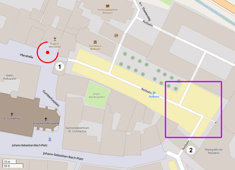
Entry gate and ticket control at the Johann-Sebastian-Bach-Platz.
136:
637:
199:
80:
360:
Add a one-line explanation of what this file represents
583:
598:
519:
104:
Commons is a freely licensed media file repository.
462:
Creative
Commons Attribution-ShareAlike 2.0 Generic
436:
Creative
Commons Attribution-ShareAlike 2.0 Generic
140: Red marker: the location of the explosion.
70:(928 × 672 pixels, file size: 258 KB, MIME type:
571:=={{int:filedesc}}== {{Information |Description=
329:https://creativecommons.org/licenses/by-sa/2.0
156:Entry gate and ticket control in Pfarrstraße.
130:Sprengstoffanschlag von Ansbach – Lageplan.jpg
85:
335:Creative Commons Attribution-Share Alike 2.0
259:
233:
195:
127:
215:
205:
14:
295:– to copy, distribute and transmit the work
600:The following other wikis use this file:
149: Violet rectangle: the event area.
618:Bomaanslag in Ansbach op 24 juli 2016
116:
585:The following page uses this file:
512:
282:Attribution-Share Alike 2.0 Generic
270:
265:
13:
365:
359:
256:
183:
174:
165:
117:
63:
671:
628:Selvmordsbombingen i Ansbach 2016
364:
350:
306:Under the following conditions:
277:This file is licensed under the
269:
264:
258:
135:
84:
31:
21:
608:Sprengstoffanschlag von Ansbach
347:
175:
595:
516:
346:
184:
166:
26:
1:
580:
372:Items portrayed in this file
252:
7:
10:
676:
654:Usage on vi.wikipedia.org
644:Usage on uk.wikipedia.org
634:Usage on pl.wikipedia.org
624:Usage on no.wikipedia.org
614:Usage on nl.wikipedia.org
604:Usage on de.wikipedia.org
320:same or compatible license
221:OpenStreetMap contributors
124:
119:
513:
16:
349:
286:
91:This is a file from the
36:
570:
198:
95:. Information from its
98:description page there
41:Size of this preview:
658:Đánh bom Ansbach 2016
648:Вибух бомби в Ансбаху
590:2016 Ansbach bombing
549:15:03, 26 July 2016
301:– to adapt the work
47:Other resolutions:
596:Global file usage
578:
446:copyright license
432:copyright license
358:
249:
248:
242:
239:Reusing this file
210:openstreetmap.org
113:
112:
93:Wikimedia Commons
32:Global file usage
667:
638:Zamach w Ansbach
561:
523:
402:copyright status
388:copyright status
356:
342:
339:
336:
333:
330:
322:as the original.
279:Creative Commons
273:
272:
268:
267:
262:
261:
236:
224:Derivative work
201:
188:
186:Français :
179:
170:
148:
139:
131:
125:
109:
88:
87:
81:
75:
73:
60:
57:928 × 672 pixels
53:640 × 463 pixels
49:320 × 232 pixels
43:800 × 579 pixels
675:
674:
670:
669:
668:
666:
665:
664:
594:
579:
567:
559:
515:
514:
511:
510:
509:
508:
507:
506:
505:
504:
502:
492:
491:
490:
488:
473:
472:
471:
470:
469:
468:
467:
466:
464:
452:
451:
450:
448:
429:
428:
427:
426:
425:
424:
423:
422:
420:
408:
407:
406:
404:
385:
384:
383:
382:
381:
379:
363:
362:
361:
344:
343:
340:
337:
334:
331:
328:
327:
285:
274:
255:
250:
191:
182:
173:
162:
155:
147:
142:
129:
122:
115:
114:
103:
102:
101:is shown below.
77:
71:
69:
62:
61:
46:
12:
11:
5:
673:
663:
662:
661:
660:
652:
651:
650:
642:
641:
640:
632:
631:
630:
622:
621:
620:
612:
611:
610:
597:
593:
592:
582:
577:
576:
569:
565:
562:
556:
551:
546:
542:
541:
538:
535:
532:
529:
526:
518:
503:
500:
498:
497:
496:
494:
493:
489:
484:
482:
481:
480:
479:
477:
465:
460:
458:
457:
456:
454:
453:
449:
444:
442:
441:
440:
439:
437:
433:
421:
416:
414:
413:
412:
410:
409:
405:
400:
398:
397:
396:
395:
393:
389:
380:
375:
373:
370:
369:
368:
367:
355:
354:
351:
348:
326:
325:
324:
323:
313:
304:
303:
302:
296:
289:You are free:
276:
275:
257:
254:
251:
247:
246:
243:
231:
230:
229:
228:
222:
217:
213:
212:
207:
203:
202:
197:
193:
192:
158:
151:
143:
132:
123:
121:
118:
111:
110:
89:
79:
78:
40:
35:
34:
29:
24:
19:
9:
6:
4:
3:
2:
672:
659:
656:
655:
653:
649:
646:
645:
643:
639:
636:
635:
633:
629:
626:
625:
623:
619:
616:
615:
613:
609:
606:
605:
603:
602:
601:
591:
588:
587:
586:
574:
568:
563:
557:
555:
552:
550:
547:
544:
543:
539:
536:
533:
530:
527:
525:
524:
522:
499:
487:
483:
463:
459:
447:
443:
419:
415:
403:
399:
378:
374:
371:
352:
345:
332:CC BY-SA 2.0
321:
317:
314:
311:
308:
307:
305:
300:
297:
294:
291:
290:
288:
287:
283:
280:
263:
244:
240:
235:
232:
227:
223:
220:
219:
218:
214:
211:
208:
204:
194:
187:
178:
169:
164:
161:
157:
154:
150:
146:
141:
138:
133:
126:
107:
100:
99:
94:
90:
83:
82:
76:
67:
66:Original file
58:
54:
50:
44:
39:
33:
30:
28:
25:
23:
20:
18:
15:
599:
584:
566:MagentaGreen
520:
517:File history
501:26 July 2016
315:
309:
298:
292:
226:MagentaGreen
200:26 July 2016
185:
176:
167:
159:
152:
144:
134:
106:You can help
96:
64:
22:File history
418:copyrighted
392:copyrighted
316:share alike
310:attribution
128:Description
581:File usage
558:928 × 672
534:Dimensions
234:Permission
72:image/jpeg
27:File usage
531:Thumbnail
528:Date/Time
486:inception
476:inception
253:Licensing
181:occurred.
177:English:
172:gekommen.
168:Deutsch:
560:(258 KB)
353:Captions
299:to remix
293:to share
284:license.
545:current
540:Comment
377:depicts
357:English
120:Summary
68:
216:Author
206:Source
190:lieu.
573:19px
537:User
341:true
338:true
196:Date
17:File
55:|
51:|
45:.
241:)
237:(
160:②
153:①
145:☐
108:.
74:)
59:.

