854:"}},"text\/plain":{"en":{"":"coordinates of the point of view"}}},"{\"value\":{\"latitude\":52.047651,\"longitude\":-0.197161,\"altitude\":null,\"precision\":1.0e-6,\"globe\":\"http:\\\/\\\/www.wikidata.org\\\/entity\\\/Q2\"},\"type\":\"globecoordinate\"}":{"text\/html":{"en":{"P1259":"52\u00b02'51.544"N, 0\u00b011'49.780"W"}},"text\/plain":{"en":{"P1259":"52\u00b02'51.544\"N, 0\u00b011'49.780\"W"}}},"{\"value\":{\"entity-type\":\"property\",\"numeric-id\":7787,\"id\":\"P7787\"},\"type\":\"wikibase-entityid\"}":{"text\/html":{"en":{"":"
922:"}},"text\/plain":{"en":{"":"coordinates of depicted place"}}},"{\"value\":{\"latitude\":52.04806,\"longitude\":-0.1974,\"altitude\":null,\"precision\":1.0e-5,\"globe\":\"http:\\\/\\\/www.wikidata.org\\\/entity\\\/Q2\"},\"type\":\"globecoordinate\"}":{"text\/html":{"en":{"P9149":"52\u00b02'53.02"N, 0\u00b011'50.64"W"}},"text\/plain":{"en":{"P9149":"52\u00b02'53.02\"N, 0\u00b011'50.64\"W"}}},"{\"value\":{\"entity-type\":\"property\",\"numeric-id\":7787,\"id\":\"P7787\"},\"type\":\"wikibase-entityid\"}":{"text\/html":{"en":{"":"
514:"}},"text\/plain":{"en":{"":"author name string"}}},"{\"value\":\"Richard Croft\",\"type\":\"string\"}":{"text\/html":{"en":{"P2093":"Richard Croft"}},"text\/plain":{"en":{"P2093":"Richard Croft"}}},"{\"value\":{\"entity-type\":\"property\",\"numeric-id\":2699,\"id\":\"P2699\"},\"type\":\"wikibase-entityid\"}":{"text\/html":{"en":{"":"
697:"}},"text\/plain":{"en":{"":"inception"}}},"{\"value\":{\"time\":\"+2009-07-02T00:00:00Z\",\"timezone\":0,\"before\":0,\"after\":0,\"precision\":11,\"calendarmodel\":\"http:\\\/\\\/www.wikidata.org\\\/entity\\\/Q1985727\"},\"type\":\"time\"}":{"text\/html":{"en":{"P571":"2 July 2009"}},"text\/plain":{"en":{"P571":"2 July 2009"}}}}": -->
731:
498:
249:
291:
241:
918:
263:
334:
372:
377:
72:
755:"}},"text\/plain":{"en":{"P973":"https:\/\/www.geograph.org.uk\/photo\/1384266"}}},"{\"value\":{\"entity-type\":\"property\",\"numeric-id\":137,\"id\":\"P137\"},\"type\":\"wikibase-entityid\"}":{"text\/html":{"en":{"":"
739:"}},"text\/plain":{"en":{"P7482":"file available on the internet"}}},"{\"value\":{\"entity-type\":\"property\",\"numeric-id\":7384,\"id\":\"P7384\"},\"type\":\"wikibase-entityid\"}":{"text\/html":{"en":{"":"
506:"}},"text\/plain":{"en":{"":"object of statement has role"}}},"{\"value\":{\"entity-type\":\"item\",\"numeric-id\":33231,\"id\":\"Q33231\"},\"type\":\"wikibase-entityid\"}":{"text\/html":{"en":{"P3831":"
653:"}},"text\/plain":{"en":{"":"copyright license"}}},"{\"value\":{\"entity-type\":\"item\",\"numeric-id\":19068220,\"id\":\"Q19068220\"},\"type\":\"wikibase-entityid\"}":{"text\/html":{"en":{"P275":"
609:"}},"text\/plain":{"en":{"":"copyright status"}}},"{\"value\":{\"entity-type\":\"item\",\"numeric-id\":50423863,\"id\":\"Q50423863\"},\"type\":\"wikibase-entityid\"}":{"text\/html":{"en":{"P6216":"
735:"}},"text\/plain":{"en":{"":"source of file"}}},"{\"value\":{\"entity-type\":\"item\",\"numeric-id\":74228490,\"id\":\"Q74228490\"},\"type\":\"wikibase-entityid\"}":{"text\/html":{"en":{"P7482":"
510:"}},"text\/plain":{"en":{"P3831":"photographer"}}},"{\"value\":{\"entity-type\":\"property\",\"numeric-id\":2093,\"id\":\"P2093\"},\"type\":\"wikibase-entityid\"}":{"text\/html":{"en":{"":"
926:"}},"text\/plain":{"en":{"":"heading"}}},"{\"value\":{\"amount\":\"+337\",\"unit\":\"http:\\\/\\\/www.wikidata.org\\\/entity\\\/Q28390\"},\"type\":\"quantity\"}":{"text\/html":{"en":{"P7787":"337
858:"}},"text\/plain":{"en":{"":"heading"}}},"{\"value\":{\"amount\":\"+337\",\"unit\":\"http:\\\/\\\/www.wikidata.org\\\/entity\\\/Q28390\"},\"type\":\"quantity\"}":{"text\/html":{"en":{"P7787":"337
759:"}},"text\/plain":{"en":{"":"operator"}}},"{\"value\":{\"entity-type\":\"item\",\"numeric-id\":1503119,\"id\":\"Q1503119\"},\"type\":\"wikibase-entityid\"}":{"text\/html":{"en":{"P137":"
1028:
747:"}},"text\/plain":{"en":{"P7384":"1384266"}}},"{\"value\":{\"entity-type\":\"property\",\"numeric-id\":973,\"id\":\"P973\"},\"type\":\"wikibase-entityid\"}":{"text\/html":{"en":{"":"
502:"}},"text\/plain":{"en":{"":"creator"}}},"{\"value\":{\"entity-type\":\"property\",\"numeric-id\":3831,\"id\":\"P3831\"},\"type\":\"wikibase-entityid\"}":{"text\/html":{"en":{"":"
605:
751:"}},"text\/plain":{"en":{"":"described at URL"}}},"{\"value\":\"https:\\\/\\\/www.geograph.org.uk\\\/photo\\\/1384266\",\"type\":\"string\"}":{"text\/html":{"en":{"P973":"
518:"}},"text\/plain":{"en":{"":"URL"}}},"{\"value\":\"https:\\\/\\\/www.geograph.org.uk\\\/profile\\\/1904\",\"type\":\"string\"}":{"text\/html":{"en":{"P2699":"
282:
43:
743:"}},"text\/plain":{"en":{"":"geograph.org.uk image ID"}}},"{\"value\":\"1384266\",\"type\":\"string\"}":{"text\/html":{"en":{"P7384":"
232:
424:– You must give appropriate credit, provide a link to the license, and indicate if changes were made. You may do so in any reasonable manner, but not in any way that suggests the licensor endorses you or your use.
246:
296:
1038:
83:
51:
744:
736:
654:
610:
760:
1073:
507:
923:
919:
855:
851:
740:
732:
606:
515:
511:
503:
752:
756:
748:
694:
650:
519:
499:
1063:
657:"}},"text\/plain":{"en":{"P275":"Creative Commons Attribution-ShareAlike 2.0 Generic"}}}}": -->
169:
522:"}},"text\/plain":{"en":{"P2699":"https:\/\/www.geograph.org.uk\/profile\/1904"}}}}": -->
786:
680:
636:
306:
256:
836:
341:
1214:
This file contains additional information, probably added from the digital camera or scanner used to create or digitize it.
431:
563:
964:
937:
896:
869:
799:
770:
620:
584:
571:
556:
1027:
1022:
42:
829:
814:
704:
664:
529:
488:
763:"}},"text\/plain":{"en":{"P137":"Geograph Britain and Ireland"}}}}": -->
387:
1217:
If the file has been modified from its original state, some details may not fully reflect the modified file.
430:– If you remix, transform, or build upon the material, you must distribute your contributions under the
348:
on the
Geograph website for the photographer's contact details. The copyright on this image is owned by
613:"}},"text\/plain":{"en":{"P6216":"copyrighted"}}}}": -->
930:"}},"text\/plain":{"en":{"P7787":"337 degree"}}}}": -->
862:"}},"text\/plain":{"en":{"P7787":"337 degree"}}}}": -->
91:
201:
1091:
1045:== Summary == {{Information |Description=St.Nicholas' church |Source=From ; transferd by
1126:
821:
806:
591:
384:
185:
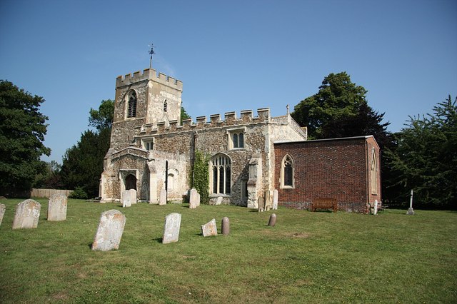
8:
328:
312:
262:
353:
78:
478:
139:
158:
143:
1046:
947:
879:
780:
714:
674:
630:
539:
333:
345:
1068:
995:
Click on a date/time to view the file as it appeared at that time.
298:
248:
233:
52° 02′ 51.54″ N, 0° 11′ 49.78″ W
147:
1074:
User:Alex.brad/List of churches in the
Diocese of St Albans
283:
52° 02′ 53″ N, 0° 11′ 51″ W
128:
66:
1097:كنيسه القديس نيكولاس (نورث هيرتفوردشير, المملكه المتحده)
1156:
1106:
472:
Add a one-line explanation of what this file represents
52:
St.Nicholas'_church_-_geograph.org.uk_-_1384266.jpg
1201:
1186:
1176:
1166:
1146:
1136:
1116:
1196:
1057:
1082:
993:
176:
Creative
Commons Attribution Share-alike license 2.0
90:
Commons is a freely licensed media file repository.
681:
Creative
Commons Attribution-ShareAlike 2.0 Generic
655:
Creative
Commons Attribution-ShareAlike 2.0 Generic
116:
St.Nicholas' church - geograph.org.uk - 1384266.jpg
1064:Grade II* listed buildings in North Hertfordshire
56:(640 × 426 pixels, file size: 77 KB, MIME type:
441:https://creativecommons.org/licenses/by-sa/2.0
71:
753:https:\/\/www.geograph.org.uk\/photo\/1384266
447:Creative Commons Attribution-Share Alike 2.0
365:
164:
124:
113:
520:https:\/\/www.geograph.org.uk\/profile\/1904
154:
134:
14:
927:
859:
407:– to copy, distribute and transmit the work
1084:The following other wikis use this file:
822:https://www.geograph.org.uk/photo/1384266
592:https://www.geograph.org.uk/profile/1904
305:View this and other nearby images on:
255:View this and other nearby images on:
1059:The following 3 pages use this file:
208:
102:
352:and is licensed for reuse under the
273:
223:
986:
388:Attribution-Share Alike 2.0 Generic
376:
371:
356:Attribution-ShareAlike 2.0 license.
13:
1212:
477:
471:
362:
339:
103:
49:
1238:
1219:
476:
870:coordinates of the point of view
852:coordinates of the point of view
462:
418:Under the following conditions:
383:This file is licensed under the
375:
370:
364:
332:
311:
297:
289:
261:
247:
239:
70:
31:
21:
1040:File Upload Bot (Magnus Manske)
459:
46:No higher resolution available.
1079:
990:
787:file available on the internet
737:file available on the internet
458:
340:This image was taken from the
26:
1:
938:coordinates of depicted place
920:coordinates of depicted place
36:
1054:
885:52°2'51.544"N, 0°11'49.780"W
837:Geograph Britain and Ireland
761:Geograph Britain and Ireland
557:object of statement has role
504:object of statement has role
484:Items portrayed in this file
324:
288:
238:
7:
1209:
1153:Usage on lld.wikipedia.org
1103:Usage on ceb.wikipedia.org
1088:Usage on arz.wikipedia.org
10:
1243:
1193:Usage on www.wikidata.org
1183:Usage on tr.wikipedia.org
1173:Usage on pl.wikipedia.org
1163:Usage on nl.wikipedia.org
1143:Usage on it.wikipedia.org
1133:Usage on fr.wikipedia.org
1123:Usage on fa.wikipedia.org
1113:Usage on cy.wikipedia.org
953:52°2'53.02"N, 0°11'50.64"W
432:same or compatible license
214:Richard Croft /
195:Richard Croft /
110:
105:
987:
16:
800:geograph.org.uk image ID
741:geograph.org.uk image ID
461:
398:
77:This is a file from the
41:
1044:
186:required by the license
127:
81:. Information from its
1023:16:30, 23 October 2009
346:this photograph's page
317:52.048060; -0.197400
267:52.047651; -0.197161
84:description page there
148:geograph_org2commons
413:– to adapt the work
216:St.Nicholas' church
197:St.Nicholas' church
120:St.Nicholas' church
572:author name string
512:author name string
1230:
1229:
1080:Global file usage
1052:
929:
861:
665:copyright license
651:copyright license
470:
361:
360:
344:collection. See
322:
321:
272:
271:
221:
220:
189:
173:
170:Reusing this file
142:; transferred by
99:
98:
79:Wikimedia Commons
32:Global file usage
1234:
1220:
1035:
997:
975:
974:
969:
907:
906:
901:
839:
834:
824:
819:
815:described at URL
809:
804:
749:described at URL
621:copyright status
607:copyright status
594:
589:
579:
576:
566:
561:
468:
454:
451:
448:
445:
442:
434:as the original.
396:
385:Creative Commons
379:
378:
374:
373:
368:
367:
354:Creative Commons
342:Geograph project
336:
329:
318:
315:
301:
300:
294:
293:
292:
286:
285:
274:
268:
265:
251:
250:
244:
243:
242:
236:
235:
224:
183:
167:
130:
117:
111:
95:
74:
73:
67:
61:
59:
1242:
1241:
1237:
1236:
1235:
1233:
1232:
1231:
1208:
1078:
1053:
1041:
1033:
989:
988:
985:
984:
983:
982:
981:
980:
979:
978:
977:
976:
972:
970:
967:
958:
957:
956:
954:
944:
943:
942:
940:
917:
916:
915:
914:
913:
912:
911:
910:
909:
908:
904:
902:
899:
890:
889:
888:
886:
876:
875:
874:
872:
849:
848:
847:
846:
845:
844:
843:
842:
841:
840:
835:
832:
826:
825:
820:
817:
811:
810:
805:
802:
793:
792:
791:
789:
777:
776:
775:
773:
730:
729:
728:
727:
726:
725:
724:
723:
721:
711:
710:
709:
707:
692:
691:
690:
689:
688:
687:
686:
685:
683:
671:
670:
669:
667:
648:
647:
646:
645:
644:
643:
642:
641:
639:
627:
626:
625:
623:
604:
603:
602:
601:
600:
599:
598:
597:
596:
595:
590:
587:
581:
580:
577:
574:
568:
567:
562:
559:
550:
549:
548:
546:
536:
535:
534:
532:
497:
496:
495:
494:
493:
491:
475:
474:
473:
456:
455:
452:
449:
446:
443:
440:
439:
397:
394:
391:
380:
357:
327:
316:
290:
281:
280:
277:Object location
266:
240:
231:
230:
227:Camera location
222:
211:
204:
192:
140:geograph.org.uk
115:
108:
101:
100:
89:
88:
87:is shown below.
63:
57:
55:
48:
47:
12:
11:
5:
1240:
1228:
1227:
1224:
1211:
1207:
1206:
1205:
1204:
1199:
1191:
1190:
1189:
1181:
1180:
1179:
1171:
1170:
1169:
1161:
1160:
1159:
1151:
1150:
1149:
1141:
1140:
1139:
1131:
1130:
1129:
1121:
1120:
1119:
1111:
1110:
1109:
1101:
1100:
1099:
1094:
1081:
1077:
1076:
1071:
1066:
1056:
1051:
1050:
1043:
1039:
1036:
1030:
1025:
1020:
1016:
1015:
1012:
1009:
1006:
1003:
1000:
992:
963:
962:
961:
960:
959:
955:
952:
950:
949:
948:
946:
945:
941:
936:
934:
933:
932:
931:
925:
921:
895:
894:
893:
892:
891:
887:
884:
882:
881:
880:
878:
877:
873:
868:
866:
865:
864:
863:
857:
853:
828:
827:
813:
812:
798:
797:
796:
795:
794:
790:
785:
783:
782:
781:
779:
778:
774:
771:source of file
769:
767:
766:
765:
764:
762:
758:
754:
750:
746:
742:
738:
734:
733:source of file
722:
719:
717:
716:
715:
713:
712:
708:
703:
701:
700:
699:
698:
696:
684:
679:
677:
676:
675:
673:
672:
668:
663:
661:
660:
659:
658:
656:
652:
640:
635:
633:
632:
631:
629:
628:
624:
619:
617:
616:
615:
614:
612:
608:
583:
582:
570:
569:
555:
554:
553:
552:
551:
547:
544:
542:
541:
540:
538:
537:
533:
528:
526:
525:
524:
523:
521:
517:
513:
509:
505:
501:
492:
487:
485:
482:
481:
480:
479:
467:
466:
463:
460:
438:
437:
436:
435:
425:
416:
415:
414:
408:
401:You are free:
392:
382:
381:
363:
359:
358:
337:
326:
323:
320:
319:
309:
303:
278:
270:
269:
259:
253:
228:
219:
218:
212:
209:
206:
205:
200:
193:
190:
178:
177:
174:
162:
161:
156:
152:
151:
136:
132:
131:
126:
122:
121:
118:
109:
107:
104:
97:
96:
75:
65:
64:
45:
40:
39:
34:
29:
24:
19:
9:
6:
4:
3:
2:
1239:
1225:
1222:
1221:
1218:
1215:
1203:
1200:
1198:
1195:
1194:
1192:
1188:
1185:
1184:
1182:
1178:
1175:
1174:
1172:
1168:
1165:
1164:
1162:
1158:
1155:
1154:
1152:
1148:
1145:
1144:
1142:
1138:
1135:
1134:
1132:
1128:
1125:
1124:
1122:
1118:
1115:
1114:
1112:
1108:
1105:
1104:
1102:
1098:
1095:
1093:
1090:
1089:
1087:
1086:
1085:
1075:
1072:
1070:
1067:
1065:
1062:
1061:
1060:
1048:
1042:
1037:
1031:
1029:
1026:
1024:
1021:
1018:
1017:
1013:
1010:
1007:
1004:
1001:
999:
998:
996:
966:
951:
939:
935:
898:
883:
871:
867:
838:
831:
823:
816:
808:
801:
788:
784:
772:
768:
718:
706:
702:
682:
678:
666:
662:
638:
634:
622:
618:
593:
586:
578:Richard Croft
573:
565:
558:
543:
531:
527:
490:
486:
483:
464:
457:
444:CC BY-SA 2.0
433:
429:
426:
423:
420:
419:
417:
412:
409:
406:
403:
402:
400:
399:
395:Richard Croft
393:Attribution:
389:
386:
369:
355:
351:
350:Richard Croft
347:
343:
338:
335:
331:
330:
314:
310:
308:
307:OpenStreetMap
304:
302:
284:
279:
276:
275:
264:
260:
258:
257:OpenStreetMap
254:
252:
234:
229:
226:
225:
217:
213:
207:
203:
199: /
198:
194:
187:
182:
180:
179:
175:
171:
166:
163:
160:
159:Richard Croft
157:
153:
149:
145:
141:
137:
133:
123:
119:
112:
93:
86:
85:
80:
76:
69:
68:
62:
53:
44:
38:
35:
33:
30:
28:
25:
23:
20:
18:
15:
1216:
1213:
1083:
1058:
994:
991:File history
564:photographer
508:photographer
427:
421:
410:
404:
349:
287:
237:
215:
202:CC BY-SA 2.0
196:
92:You can help
82:
50:
22:File history
1047:User:oxyman
720:2 July 2009
637:copyrighted
611:copyrighted
428:share alike
422:attribution
181:Attribution
144:User:oxyman
129:2 July 2009
114:Description
1223:_error
1055:File usage
1049:using . |D
1032:640 × 426
1008:Dimensions
545:some value
165:Permission
58:image/jpeg
27:File usage
1202:Q17555252
1187:Hinxworth
1177:Hinxworth
1167:Hinxworth
1157:Hinxworth
1147:Hinxworth
1137:Hinxworth
1117:Hinxworth
1107:Hinxworth
1069:Hinxworth
1005:Thumbnail
1002:Date/Time
705:inception
695:inception
325:Licensing
210:InfoField
191:InfoField
1210:Metadata
1197:Q2233534
1127:هینکسورث
1092:هينكسورث
830:operator
757:operator
465:Captions
411:to remix
405:to share
390:license.
37:Metadata
1034:(77 KB)
1019:current
1014:Comment
965:heading
924:heading
897:heading
856:heading
807:1384266
745:1384266
530:creator
500:creator
489:depicts
469:English
106:Summary
54:
973:degree
928:degree
905:degree
860:degree
295:
245:
155:Author
146:using
135:Source
138:From
1011:User
971:337
903:337
453:true
450:true
125:Date
17:File
585:URL
516:URL
968::
900::
833::
818::
803::
588::
575::
560::
1226:0
188:)
184:(
172:)
168:(
150:.
94:.
60:)
Text is available under the Creative Commons Attribution-ShareAlike License. Additional terms may apply.
_region:GB-ENG_heading:337.00&language=en)
