1069:"}},"text\/plain":{"en":{"":"checksum"}}},"{\"value\":\"bd283ad7a6ca550557bbea6739582ae5a3e67fed\",\"type\":\"string\"}":{"text\/html":{"en":{"P4092":"bd283ad7a6ca550557bbea6739582ae5a3e67fed"}},"text\/plain":{"en":{"P4092":"bd283ad7a6ca550557bbea6739582ae5a3e67fed"}}},"{\"value\":{\"entity-type\":\"property\",\"numeric-id\":459,\"id\":\"P459\"},\"type\":\"wikibase-entityid\"}":{"text\/html":{"en":{"":"
820:"}},"text\/plain":{"en":{"":"coordinates of the point of view"}}},"{\"value\":{\"latitude\":51.7522,\"longitude\":-0.339,\"altitude\":null,\"precision\":0.0001,\"globe\":\"http:\\\/\\\/www.wikidata.org\\\/entity\\\/Q2\"},\"type\":\"globecoordinate\"}":{"text\/html":{"en":{"P1259":"51\u00b045'7.9"N, 0\u00b020'20.4"W"}},"text\/plain":{"en":{"P1259":"51\u00b045'7.9\"N, 0\u00b020'20.4\"W"}}}}": -->
858:"}},"text\/plain":{"en":{"":"coordinates of depicted place"}}},"{\"value\":{\"latitude\":51.7522,\"longitude\":-0.339,\"altitude\":null,\"precision\":0.0001,\"globe\":\"http:\\\/\\\/www.wikidata.org\\\/entity\\\/Q2\"},\"type\":\"globecoordinate\"}":{"text\/html":{"en":{"P9149":"51\u00b045'7.9"N, 0\u00b020'20.4"W"}},"text\/plain":{"en":{"P9149":"51\u00b045'7.9\"N, 0\u00b020'20.4\"W"}}}}": -->
480:"}},"text\/plain":{"en":{"":"author name string"}}},"{\"value\":\"Nigel Cox\",\"type\":\"string\"}":{"text\/html":{"en":{"P2093":"Nigel Cox"}},"text\/plain":{"en":{"P2093":"Nigel Cox"}}},"{\"value\":{\"entity-type\":\"property\",\"numeric-id\":3831,\"id\":\"P3831\"},\"type\":\"wikibase-entityid\"}":{"text\/html":{"en":{"":"
663:"}},"text\/plain":{"en":{"":"inception"}}},"{\"value\":{\"time\":\"+2005-12-04T00:00:00Z\",\"timezone\":0,\"before\":0,\"after\":0,\"precision\":11,\"calendarmodel\":\"http:\\\/\\\/www.wikidata.org\\\/entity\\\/Q1985727\"},\"type\":\"time\"}":{"text\/html":{"en":{"P571":"4 December 2005"}},"text\/plain":{"en":{"P571":"4 December 2005"}}}}": -->
697:
464:
223:
1065:
237:
300:
338:
343:
72:
476:"}},"text\/plain":{"en":{"P2699":"https:\/\/www.geograph.org.uk\/profile\/2798"}}},"{\"value\":{\"entity-type\":\"property\",\"numeric-id\":2093,\"id\":\"P2093\"},\"type\":\"wikibase-entityid\"}":{"text\/html":{"en":{"":"
705:"}},"text\/plain":{"en":{"P7482":"file available on the internet"}}},"{\"value\":{\"entity-type\":\"property\",\"numeric-id\":137,\"id\":\"P137\"},\"type\":\"wikibase-entityid\"}":{"text\/html":{"en":{"":"
713:"}},"text\/plain":{"en":{"P137":"Geograph Britain and Ireland"}}},"{\"value\":{\"entity-type\":\"property\",\"numeric-id\":7384,\"id\":\"P7384\"},\"type\":\"wikibase-entityid\"}":{"text\/html":{"en":{"":"
484:"}},"text\/plain":{"en":{"":"object of statement has role"}}},"{\"value\":{\"entity-type\":\"item\",\"numeric-id\":33231,\"id\":\"Q33231\"},\"type\":\"wikibase-entityid\"}":{"text\/html":{"en":{"P3831":"
1073:"}},"text\/plain":{"en":{"":"determination method"}}},"{\"value\":{\"entity-type\":\"item\",\"numeric-id\":13414952,\"id\":\"Q13414952\"},\"type\":\"wikibase-entityid\"}":{"text\/html":{"en":{"P459":"
896:"}},"text\/plain":{"en":{"":"media type"}}},"{\"value\":\"image\\\/jpeg\",\"type\":\"string\"}":{"text\/html":{"en":{"P1163":"image\/jpeg"}},"text\/plain":{"en":{"P1163":"image\/jpeg"}}}}": -->
619:"}},"text\/plain":{"en":{"":"copyright license"}}},"{\"value\":{\"entity-type\":\"item\",\"numeric-id\":19068220,\"id\":\"Q19068220\"},\"type\":\"wikibase-entityid\"}":{"text\/html":{"en":{"P275":"
575:"}},"text\/plain":{"en":{"":"copyright status"}}},"{\"value\":{\"entity-type\":\"item\",\"numeric-id\":50423863,\"id\":\"Q50423863\"},\"type\":\"wikibase-entityid\"}":{"text\/html":{"en":{"P6216":"
701:"}},"text\/plain":{"en":{"":"source of file"}}},"{\"value\":{\"entity-type\":\"item\",\"numeric-id\":74228490,\"id\":\"Q74228490\"},\"type\":\"wikibase-entityid\"}":{"text\/html":{"en":{"P7482":"
934:"}},"text\/plain":{"en":{"":"data size"}}},"{\"value\":{\"amount\":\"+133601\",\"unit\":\"http:\\\/\\\/www.wikidata.org\\\/entity\\\/Q8799\"},\"type\":\"quantity\"}":{"text\/html":{"en":{"P3575":"133,601
1174:
979:"}},"text\/plain":{"en":{"":"height"}}},"{\"value\":{\"amount\":\"+480\",\"unit\":\"http:\\\/\\\/www.wikidata.org\\\/entity\\\/Q355198\"},\"type\":\"quantity\"}":{"text\/html":{"en":{"P2048":"480
709:"}},"text\/plain":{"en":{"":"operator"}}},"{\"value\":{\"entity-type\":\"item\",\"numeric-id\":1503119,\"id\":\"Q1503119\"},\"type\":\"wikibase-entityid\"}":{"text\/html":{"en":{"P137":"
1024:"}},"text\/plain":{"en":{"":"width"}}},"{\"value\":{\"amount\":\"+640\",\"unit\":\"http:\\\/\\\/www.wikidata.org\\\/entity\\\/Q355198\"},\"type\":\"quantity\"}":{"text\/html":{"en":{"P2049":"640
721:"}},"text\/plain":{"en":{"P7384":"87855"}}},"{\"value\":{\"entity-type\":\"property\",\"numeric-id\":973,\"id\":\"P973\"},\"type\":\"wikibase-entityid\"}":{"text\/html":{"en":{"":"
468:"}},"text\/plain":{"en":{"":"creator"}}},"{\"value\":{\"entity-type\":\"property\",\"numeric-id\":2699,\"id\":\"P2699\"},\"type\":\"wikibase-entityid\"}":{"text\/html":{"en":{"":"
1020:
717:"}},"text\/plain":{"en":{"":"geograph.org.uk image ID"}}},"{\"value\":\"87855\",\"type\":\"string\"}":{"text\/html":{"en":{"P7384":"
256:
214:
390:– You must give appropriate credit, provide a link to the license, and indicate if changes were made. You may do so in any reasonable manner, but not in any way that suggests the licensor endorses you or your use.
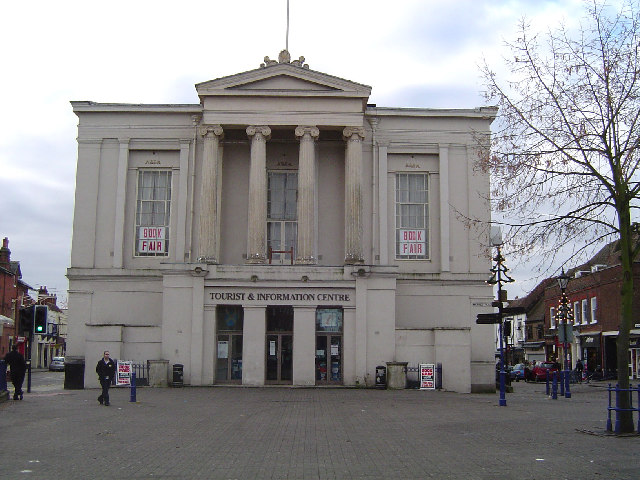
1191:== {{int:filedesc}} == {{Information |description={{en|1=St Albans: The Town Hall. The nineteenth century Grade II listed Town Hall in the Market Place.}} |date=2005-12-04 |source=From |author=[http
262:
220:
83:
51:
1074:
702:
620:
576:
718:
710:
485:
1066:
1021:
976:
931:
893:
855:
817:
714:
698:
572:
481:
477:
469:
1070:
722:
706:
660:
616:
473:
465:
726:
1184:
623:"}},"text\/plain":{"en":{"P275":"Creative Commons Attribution-ShareAlike 2.0 Generic"}}}}": -->
729:"}},"text\/plain":{"en":{"P973":"https:\/\/www.geograph.org.uk\/photo\/87855"}}}}": -->
1118:
752:
646:
602:
272:
230:
772:
307:
1241:
This file contains additional information, probably added from the digital camera or scanner used to create or digitize it.
397:
1173:
1168:
557:
42:
1084:
1035:
990:
945:
903:
865:
827:
780:
736:
586:
550:
537:
522:
1111:
795:
765:
670:
630:
495:
454:
353:
1244:
If the file has been modified from its original state, some details may not fully reflect the modified file.
396:– If you remix, transform, or build upon the material, you must distribute your contributions under the
314:
on the
Geograph website for the photographer's contact details. The copyright on this image is owned by
938:"}},"text\/plain":{"en":{"P3575":"133,601 byte"}}}}": -->
488:"}},"text\/plain":{"en":{"P3831":"photographer"}}}}": -->
126:
St Albans: The former Town Hall. The nineteenth century Grade II listed Town Hall in the Market Place.
579:"}},"text\/plain":{"en":{"P6216":"copyrighted"}}}}": -->
1205:
1028:"}},"text\/plain":{"en":{"P2049":"640 pixel"}}}}": -->
983:"}},"text\/plain":{"en":{"P2048":"480 pixel"}}}}": -->
91:
183:
1077:"}},"text\/plain":{"en":{"P459":"SHA-1"}}}}": -->
529:
350:
167:
802:
787:
8:
294:
278:
236:
1210:
319:
78:
444:
156:
146:
1094:
1045:
1000:
955:
913:
875:
837:
746:
680:
640:
596:
505:
299:
311:
1141:
Click on a date/time to view the file as it appeared at that time.
264:
222:
257:
51° 45′ 08″ N, 0° 20′ 20″ W
215:
51° 45′ 08″ N, 0° 20′ 20″ W
135:
66:
438:
Add a one-line explanation of what this file represents
1228:
116:
St Albans, The Town Hall - geograph.org.uk - 87855.jpg
52:
St_Albans,_The_Town_Hall_-_geograph.org.uk_-_87855.jpg
1199:
1219:
1139:
90:
Commons is a freely licensed media file repository.
647:
Creative
Commons Attribution-ShareAlike 2.0 Generic
621:
Creative
Commons Attribution-ShareAlike 2.0 Generic
56:(640 × 480 pixels, file size: 130 KB, MIME type:
407:https://creativecommons.org/licenses/by-sa/2.0
71:
413:Creative Commons Attribution-Share Alike 2.0
331:
131:
113:
474:https:\/\/www.geograph.org.uk\/profile\/2798
152:
141:
14:
1025:
980:
935:
727:https:\/\/www.geograph.org.uk\/photo\/87855
373:– to copy, distribute and transmit the work
1221:The following other wikis use this file:
1100:bd283ad7a6ca550557bbea6739582ae5a3e67fed
530:https://www.geograph.org.uk/profile/2798
803:https://www.geograph.org.uk/photo/87855
271:View this and other nearby images on:
229:View this and other nearby images on:
1201:The following 2 pages use this file:
190:
102:
318:and is licensed for reuse under the
247:
205:
1132:
354:Attribution-Share Alike 2.0 Generic
342:
337:
322:Attribution-ShareAlike 2.0 license.
13:
1239:
443:
437:
328:
305:
120:
103:
49:
1265:
1246:
442:
828:coordinates of the point of view
818:coordinates of the point of view
428:
384:Under the following conditions:
349:This file is licensed under the
341:
336:
330:
298:
277:
263:
235:
221:
70:
31:
21:
425:
121:
46:No higher resolution available.
1216:
1136:
753:file available on the internet
703:file available on the internet
424:
306:This image was taken from the
26:
1:
866:coordinates of depicted place
856:coordinates of depicted place
36:
1196:
773:Geograph Britain and Ireland
711:Geograph Britain and Ireland
551:object of statement has role
482:object of statement has role
450:Items portrayed in this file
290:
7:
1236:
10:
1270:
1225:Usage on www.wikidata.org
398:same or compatible license
110:
105:
1133:
16:
1206:George Smith (architect)
881:51°45'7.9"N, 0°20'20.4"W
843:51°45'7.9"N, 0°20'20.4"W
781:geograph.org.uk image ID
715:geograph.org.uk image ID
427:
364:
198:St Albans: The Town Hall
179:St Albans: The Town Hall
77:This is a file from the
41:
1190:
168:required by the license
134:
81:. Information from its
1169:23:50, 30 January 2010
312:this photograph's page
283:51.752200; -0.339000
241:51.752200; -0.339000
196:Nigel Cox /
177:Nigel Cox /
84:description page there
1112:determination method
1071:determination method
379:– to adapt the work
538:author name string
478:author name string
1257:
1256:
1217:Global file usage
1211:St Albans Museums
1194:
1027:
982:
937:
631:copyright license
617:copyright license
436:
327:
326:
310:collection. See
288:
287:
246:
245:
203:
202:
171:
99:
98:
79:Wikimedia Commons
32:Global file usage
1261:
1247:
1181:
1143:
1121:
1116:
1054:
1009:
964:
805:
800:
796:described at URL
790:
785:
775:
770:
723:described at URL
587:copyright status
573:copyright status
560:
555:
545:
542:
532:
527:
434:
420:
417:
414:
411:
408:
400:as the original.
362:
351:Creative Commons
345:
344:
340:
339:
334:
333:
320:Creative Commons
308:Geograph project
302:
295:
284:
281:
267:
266:
260:
259:
248:
242:
239:
225:
224:
218:
217:
206:
165:
137:
125:
117:
111:
95:
74:
73:
67:
61:
59:
1269:
1268:
1264:
1263:
1262:
1260:
1259:
1258:
1235:
1215:
1195:
1187:
1179:
1135:
1134:
1131:
1130:
1129:
1128:
1127:
1126:
1125:
1124:
1123:
1122:
1117:
1114:
1105:
1104:
1103:
1101:
1091:
1090:
1089:
1087:
1064:
1063:
1062:
1061:
1060:
1059:
1058:
1057:
1055:
1052:
1042:
1041:
1040:
1038:
1019:
1018:
1017:
1016:
1015:
1014:
1013:
1012:
1010:
1007:
997:
996:
995:
993:
974:
973:
972:
971:
970:
969:
968:
967:
965:
962:
952:
951:
950:
948:
929:
928:
927:
926:
925:
924:
923:
922:
920:
910:
909:
908:
906:
891:
890:
889:
888:
887:
886:
885:
884:
882:
872:
871:
870:
868:
853:
852:
851:
850:
849:
848:
847:
846:
844:
834:
833:
832:
830:
815:
814:
813:
812:
811:
810:
809:
808:
807:
806:
801:
798:
792:
791:
786:
783:
777:
776:
771:
768:
759:
758:
757:
755:
743:
742:
741:
739:
696:
695:
694:
693:
692:
691:
690:
689:
687:
686:4 December 2005
677:
676:
675:
673:
658:
657:
656:
655:
654:
653:
652:
651:
649:
637:
636:
635:
633:
614:
613:
612:
611:
610:
609:
608:
607:
605:
593:
592:
591:
589:
570:
569:
568:
567:
566:
565:
564:
563:
562:
561:
556:
553:
547:
546:
543:
540:
534:
533:
528:
525:
516:
515:
514:
512:
502:
501:
500:
498:
463:
462:
461:
460:
459:
457:
441:
440:
439:
422:
421:
418:
415:
412:
409:
406:
405:
363:
360:
357:
346:
323:
293:
282:
255:
254:
251:Object location
240:
213:
212:
209:Camera location
204:
193:
186:
174:
147:geograph.org.uk
136:4 December 2005
127:
115:
108:
101:
100:
89:
88:
87:is shown below.
63:
57:
55:
48:
47:
12:
11:
5:
1267:
1255:
1254:
1251:
1238:
1234:
1233:
1232:
1231:
1218:
1214:
1213:
1208:
1198:
1193:
1192:
1189:
1185:
1182:
1176:
1171:
1166:
1162:
1161:
1158:
1155:
1152:
1149:
1146:
1138:
1110:
1109:
1108:
1107:
1106:
1102:
1099:
1097:
1096:
1095:
1093:
1092:
1088:
1083:
1081:
1080:
1079:
1078:
1076:
1072:
1068:
1056:
1050:
1048:
1047:
1046:
1044:
1043:
1039:
1034:
1032:
1031:
1030:
1029:
1023:
1011:
1005:
1003:
1002:
1001:
999:
998:
994:
989:
987:
986:
985:
984:
978:
966:
960:
958:
957:
956:
954:
953:
949:
944:
942:
941:
940:
939:
933:
921:
918:
916:
915:
914:
912:
911:
907:
902:
900:
899:
898:
897:
895:
883:
880:
878:
877:
876:
874:
873:
869:
864:
862:
861:
860:
859:
857:
845:
842:
840:
839:
838:
836:
835:
831:
826:
824:
823:
822:
821:
819:
794:
793:
779:
778:
764:
763:
762:
761:
760:
756:
751:
749:
748:
747:
745:
744:
740:
737:source of file
735:
733:
732:
731:
730:
728:
724:
720:
716:
712:
708:
704:
700:
699:source of file
688:
685:
683:
682:
681:
679:
678:
674:
669:
667:
666:
665:
664:
662:
650:
645:
643:
642:
641:
639:
638:
634:
629:
627:
626:
625:
624:
622:
618:
606:
601:
599:
598:
597:
595:
594:
590:
585:
583:
582:
581:
580:
578:
574:
549:
548:
536:
535:
521:
520:
519:
518:
517:
513:
510:
508:
507:
506:
504:
503:
499:
494:
492:
491:
490:
489:
487:
483:
479:
475:
471:
467:
458:
453:
451:
448:
447:
446:
445:
433:
432:
429:
426:
404:
403:
402:
401:
391:
382:
381:
380:
374:
367:You are free:
358:
348:
347:
329:
325:
324:
303:
292:
289:
286:
285:
275:
269:
252:
244:
243:
233:
227:
210:
201:
200:
194:
191:
188:
187:
182:
175:
172:
160:
159:
154:
150:
149:
143:
139:
138:
133:
129:
128:
118:
109:
107:
104:
97:
96:
75:
65:
64:
45:
40:
39:
34:
29:
24:
19:
9:
6:
4:
3:
2:
1266:
1252:
1249:
1248:
1245:
1242:
1230:
1227:
1226:
1224:
1223:
1222:
1212:
1209:
1207:
1204:
1203:
1202:
1188:
1183:
1177:
1175:
1172:
1170:
1167:
1164:
1163:
1159:
1156:
1153:
1150:
1147:
1145:
1144:
1142:
1120:
1113:
1098:
1086:
1082:
1049:
1037:
1033:
1004:
992:
988:
959:
947:
943:
917:
905:
901:
879:
867:
863:
841:
829:
825:
804:
797:
789:
782:
774:
767:
754:
750:
738:
734:
684:
672:
668:
648:
644:
632:
628:
604:
600:
588:
584:
559:
552:
539:
531:
524:
509:
497:
493:
456:
452:
449:
430:
423:
410:CC BY-SA 2.0
399:
395:
392:
389:
386:
385:
383:
378:
375:
372:
369:
368:
366:
365:
359:Attribution:
355:
352:
335:
321:
317:
313:
309:
304:
301:
297:
296:
280:
276:
274:
273:OpenStreetMap
270:
268:
258:
253:
250:
249:
238:
234:
232:
231:OpenStreetMap
228:
226:
216:
211:
208:
207:
199:
195:
189:
185:
181: /
180:
176:
169:
164:
162:
161:
158:
155:
151:
148:
144:
140:
130:
124:
119:
112:
93:
86:
85:
80:
76:
69:
68:
62:
53:
44:
38:
35:
33:
30:
28:
25:
23:
20:
18:
15:
1243:
1240:
1220:
1200:
1140:
1137:File history
558:photographer
486:photographer
393:
387:
376:
370:
315:
197:
184:CC BY-SA 2.0
178:
122:
92:You can help
82:
50:
22:File history
1186:GeographBot
603:copyrighted
577:copyrighted
394:share alike
388:attribution
163:Attribution
114:Description
1250:_error
1197:File usage
1178:640 × 480
1154:Dimensions
919:image/jpeg
904:media type
894:media type
511:some value
58:image/jpeg
27:File usage
1229:Q17555411
1151:Thumbnail
1148:Date/Time
946:data size
932:data size
671:inception
661:inception
544:Nigel Cox
361:Nigel Cox
316:Nigel Cox
291:Licensing
192:InfoField
173:InfoField
157:Nigel Cox
123:English:
1237:Metadata
1180:(130 KB)
1085:checksum
1067:checksum
961:133,601
766:operator
707:operator
431:Captions
377:to remix
371:to share
356:license.
37:Metadata
1165:current
1160:Comment
496:creator
466:creator
455:depicts
435:English
106:Summary
54:
991:height
977:height
261:
219:
153:Author
142:Source
1119:SHA-1
1075:SHA-1
1053:pixel
1036:width
1026:pixel
1022:width
1008:pixel
981:pixel
788:87855
719:87855
145:From
1157:User
1051:640
1006:480
963:byte
936:byte
419:true
416:true
132:Date
17:File
523:URL
470:URL
1115::
799::
784::
769::
554::
541::
526::
1253:0
170:)
166:(
94:.
60:)
Text is available under the Creative Commons Attribution-ShareAlike License. Additional terms may apply.
_&language=en)
_&language=en)
