855:"}},"text\/plain":{"en":{"":"coordinates of the point of view"}}},"{\"value\":{\"latitude\":51.6327,\"longitude\":-3.944,\"altitude\":null,\"precision\":0.0001,\"globe\":\"http:\\\/\\\/www.wikidata.org\\\/entity\\\/Q2\"},\"type\":\"globecoordinate\"}":{"text\/html":{"en":{"P1259":"51\u00b037'57.7"N, 3\u00b056'38.4"W"}},"text\/plain":{"en":{"P1259":"51\u00b037'57.7\"N, 3\u00b056'38.4\"W"}}},"{\"value\":{\"entity-type\":\"property\",\"numeric-id\":7787,\"id\":\"P7787\"},\"type\":\"wikibase-entityid\"}":{"text\/html":{"en":{"":"
923:"}},"text\/plain":{"en":{"":"coordinates of depicted place"}}},"{\"value\":{\"latitude\":51.6327,\"longitude\":-3.944,\"altitude\":null,\"precision\":0.0001,\"globe\":\"http:\\\/\\\/www.wikidata.org\\\/entity\\\/Q2\"},\"type\":\"globecoordinate\"}":{"text\/html":{"en":{"P9149":"51\u00b037'57.7"N, 3\u00b056'38.4"W"}},"text\/plain":{"en":{"P9149":"51\u00b037'57.7\"N, 3\u00b056'38.4\"W"}}},"{\"value\":{\"entity-type\":\"property\",\"numeric-id\":7787,\"id\":\"P7787\"},\"type\":\"wikibase-entityid\"}":{"text\/html":{"en":{"":"
515:"}},"text\/plain":{"en":{"":"author name string"}}},"{\"value\":\"Chris Henley\",\"type\":\"string\"}":{"text\/html":{"en":{"P2093":"Chris Henley"}},"text\/plain":{"en":{"P2093":"Chris Henley"}}},"{\"value\":{\"entity-type\":\"property\",\"numeric-id\":3831,\"id\":\"P3831\"},\"type\":\"wikibase-entityid\"}":{"text\/html":{"en":{"":"
698:"}},"text\/plain":{"en":{"":"inception"}}},"{\"value\":{\"time\":\"+2006-10-21T00:00:00Z\",\"timezone\":0,\"before\":0,\"after\":0,\"precision\":11,\"calendarmodel\":\"http:\\\/\\\/www.wikidata.org\\\/entity\\\/Q1985727\"},\"type\":\"time\"}":{"text\/html":{"en":{"P571":"21 October 2006"}},"text\/plain":{"en":{"P571":"21 October 2006"}}}}": -->
732:
300:
250:
292:
242:
919:
264:
335:
373:
378:
72:
511:"}},"text\/plain":{"en":{"P2699":"https:\/\/www.geograph.org.uk\/profile\/7582"}}},"{\"value\":{\"entity-type\":\"property\",\"numeric-id\":2093,\"id\":\"P2093\"},\"type\":\"wikibase-entityid\"}":{"text\/html":{"en":{"":"
740:"}},"text\/plain":{"en":{"P7482":"file available on the internet"}}},"{\"value\":{\"entity-type\":\"property\",\"numeric-id\":137,\"id\":\"P137\"},\"type\":\"wikibase-entityid\"}":{"text\/html":{"en":{"":"
748:"}},"text\/plain":{"en":{"P137":"Geograph Britain and Ireland"}}},"{\"value\":{\"entity-type\":\"property\",\"numeric-id\":7384,\"id\":\"P7384\"},\"type\":\"wikibase-entityid\"}":{"text\/html":{"en":{"":"
519:"}},"text\/plain":{"en":{"":"object of statement has role"}}},"{\"value\":{\"entity-type\":\"item\",\"numeric-id\":33231,\"id\":\"Q33231\"},\"type\":\"wikibase-entityid\"}":{"text\/html":{"en":{"P3831":"
654:"}},"text\/plain":{"en":{"":"copyright license"}}},"{\"value\":{\"entity-type\":\"item\",\"numeric-id\":19068220,\"id\":\"Q19068220\"},\"type\":\"wikibase-entityid\"}":{"text\/html":{"en":{"P275":"
610:"}},"text\/plain":{"en":{"":"copyright status"}}},"{\"value\":{\"entity-type\":\"item\",\"numeric-id\":50423863,\"id\":\"Q50423863\"},\"type\":\"wikibase-entityid\"}":{"text\/html":{"en":{"P6216":"
736:"}},"text\/plain":{"en":{"":"source of file"}}},"{\"value\":{\"entity-type\":\"item\",\"numeric-id\":74228490,\"id\":\"Q74228490\"},\"type\":\"wikibase-entityid\"}":{"text\/html":{"en":{"P7482":"
927:"}},"text\/plain":{"en":{"":"heading"}}},"{\"value\":{\"amount\":\"+157\",\"unit\":\"http:\\\/\\\/www.wikidata.org\\\/entity\\\/Q28390\"},\"type\":\"quantity\"}":{"text\/html":{"en":{"P7787":"157
859:"}},"text\/plain":{"en":{"":"heading"}}},"{\"value\":{\"amount\":\"+157\",\"unit\":\"http:\\\/\\\/www.wikidata.org\\\/entity\\\/Q28390\"},\"type\":\"quantity\"}":{"text\/html":{"en":{"P7787":"157
744:"}},"text\/plain":{"en":{"":"operator"}}},"{\"value\":{\"entity-type\":\"item\",\"numeric-id\":1503119,\"id\":\"Q1503119\"},\"type\":\"wikibase-entityid\"}":{"text\/html":{"en":{"P137":"
1029:
756:"}},"text\/plain":{"en":{"P7384":"264580"}}},"{\"value\":{\"entity-type\":\"property\",\"numeric-id\":973,\"id\":\"P973\"},\"type\":\"wikibase-entityid\"}":{"text\/html":{"en":{"":"
503:"}},"text\/plain":{"en":{"":"creator"}}},"{\"value\":{\"entity-type\":\"property\",\"numeric-id\":2699,\"id\":\"P2699\"},\"type\":\"wikibase-entityid\"}":{"text\/html":{"en":{"":"
606:
283:
752:"}},"text\/plain":{"en":{"":"geograph.org.uk image ID"}}},"{\"value\":\"264580\",\"type\":\"string\"}":{"text\/html":{"en":{"P7384":"
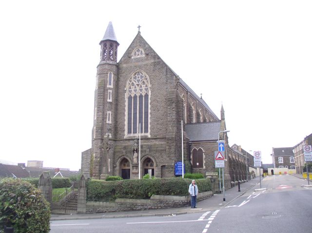
1046:== {{int:filedesc}} == {{Information |description={{en|1=St Joseph's Cathedral This Roman Catholic cathedral was designed by Pugin and built as a parish church. It took two years to build at a cost of £10,000 and was opened in 1888. In 1987 it became a
233:
425:– You must give appropriate credit, provide a link to the license, and indicate if changes were made. You may do so in any reasonable manner, but not in any way that suggests the licensor endorses you or your use.
297:
247:
83:
51:
753:
737:
655:
611:
745:
175:
130:
and built as a parish church. It took two years to build at a cost of £10,000 and was opened in 1888. In 1987 it became a cathedral at the inauguration of the redefined
520:
924:
920:
856:
852:
749:
733:
607:
516:
512:
504:
761:
757:
741:
695:
651:
508:
500:
1039:
658:"}},"text\/plain":{"en":{"P275":"Creative Commons Attribution-ShareAlike 2.0 Generic"}}}}": -->
764:"}},"text\/plain":{"en":{"P973":"https:\/\/www.geograph.org.uk\/photo\/264580"}}}}": -->
787:
681:
637:
307:
257:
807:
342:
1111:
This file contains additional information, probably added from the digital camera or scanner used to create or digitize it.
432:
592:
1028:
1023:
965:
938:
897:
870:
815:
771:
621:
585:
572:
557:
42:
131:
830:
800:
705:
665:
530:
489:
1060:
127:
388:
1114:
If the file has been modified from its original state, some details may not fully reflect the modified file.
431:– If you remix, transform, or build upon the material, you must distribute your contributions under the
349:
on the
Geograph website for the photographer's contact details. The copyright on this image is owned by
523:"}},"text\/plain":{"en":{"P3831":"photographer"}}}}": -->
614:"}},"text\/plain":{"en":{"P6216":"copyrighted"}}}}": -->
931:"}},"text\/plain":{"en":{"P7787":"157 degree"}}}}": -->
863:"}},"text\/plain":{"en":{"P7787":"157 degree"}}}}": -->
91:
202:
126:
St Joseph's
Cathedral, Swansea/Abertawe, Wales. This Roman Catholic cathedral was designed by
837:
822:
564:
385:
186:
8:
329:
313:
263:
354:
78:
479:
164:
154:
948:
880:
781:
715:
675:
631:
540:
334:
346:
1098:
996:
Click on a date/time to view the file as it appeared at that time.
299:
249:
1088:
1078:
284:
51° 37′ 58″ N, 3° 56′ 38″ W
234:
51° 37′ 58″ N, 3° 56′ 38″ W
143:
66:
52:
St_Joseph's_Cathedral_-_geograph.org.uk_-_264580.jpg
473:
Add a one-line explanation of what this file represents
176:
St Joseph's
Cathedral - geograph.org.uk - 264580-2.jpg
1054:
1069:
994:
116:
St Joseph's
Cathedral - geograph.org.uk - 264580.jpg
90:
Commons is a freely licensed media file repository.
682:
Creative
Commons Attribution-ShareAlike 2.0 Generic
656:
Creative
Commons Attribution-ShareAlike 2.0 Generic
56:(640 × 478 pixels, file size: 44 KB, MIME type:
442:https://creativecommons.org/licenses/by-sa/2.0
71:
448:Creative Commons Attribution-Share Alike 2.0
366:
139:
113:
762:https:\/\/www.geograph.org.uk\/photo\/264580
509:https:\/\/www.geograph.org.uk\/profile\/7582
170:
160:
149:
14:
928:
860:
408:– to copy, distribute and transmit the work
1071:The following other wikis use this file:
838:https://www.geograph.org.uk/photo/264580
565:https://www.geograph.org.uk/profile/7582
306:View this and other nearby images on:
256:View this and other nearby images on:
209:
174:Derivative works of this file:
102:
353:and is licensed for reuse under the
274:
224:
1056:The following page uses this file:
987:
389:Attribution-Share Alike 2.0 Generic
377:
372:
357:Attribution-ShareAlike 2.0 license.
13:
1109:
478:
472:
363:
340:
120:
103:
49:
1135:
1116:
1061:Roman Catholic Diocese of Menevia
477:
871:coordinates of the point of view
853:coordinates of the point of view
463:
419:Under the following conditions:
384:This file is licensed under the
376:
371:
365:
333:
312:
298:
290:
262:
248:
240:
70:
31:
21:
460:
121:
46:No higher resolution available.
1066:
991:
788:file available on the internet
738:file available on the internet
459:
341:This image was taken from the
26:
1:
939:coordinates of depicted place
921:coordinates of depicted place
36:
1051:
808:Geograph Britain and Ireland
746:Geograph Britain and Ireland
586:object of statement has role
517:object of statement has role
485:Items portrayed in this file
325:
289:
239:
7:
1106:
10:
1140:
1095:Usage on no.wikipedia.org
1085:Usage on jv.wikipedia.org
1075:Usage on id.wikipedia.org
433:same or compatible license
110:
105:
988:
954:51°37'57.7"N, 3°56'38.4"W
886:51°37'57.7"N, 3°56'38.4"W
215:Chris Henley /
196:Chris Henley /
16:
816:geograph.org.uk image ID
750:geograph.org.uk image ID
462:
399:
77:This is a file from the
41:
1045:
1024:16:24, 12 December 2010
187:required by the license
142:
81:. Information from its
347:this photograph's page
318:51.632700; -3.944000
268:51.632700; -3.944000
84:description page there
217:St Joseph's Cathedral
198:St Joseph's Cathedral
414:– to adapt the work
1099:Menevia bispedømme
1089:Kabiskopan Menevia
573:author name string
513:author name string
132:Diocese of Menevia
1127:
1126:
1079:Keuskupan Menevia
1067:Global file usage
1049:
930:
862:
666:copyright license
652:copyright license
471:
362:
361:
345:collection. See
323:
322:
273:
272:
222:
221:
190:
99:
98:
79:Wikimedia Commons
32:Global file usage
1131:
1117:
1036:
998:
976:
975:
970:
908:
907:
902:
840:
835:
831:described at URL
825:
820:
810:
805:
758:described at URL
622:copyright status
608:copyright status
595:
590:
580:
577:
567:
562:
469:
455:
452:
449:
446:
443:
435:as the original.
397:
386:Creative Commons
380:
379:
375:
374:
369:
368:
355:Creative Commons
343:Geograph project
337:
330:
319:
316:
302:
301:
295:
294:
293:
287:
286:
275:
269:
266:
252:
251:
245:
244:
243:
237:
236:
225:
184:
145:
125:
117:
111:
95:
74:
73:
67:
61:
59:
1139:
1138:
1134:
1133:
1132:
1130:
1129:
1128:
1105:
1065:
1050:
1042:
1034:
990:
989:
986:
985:
984:
983:
982:
981:
980:
979:
978:
977:
973:
971:
968:
959:
958:
957:
955:
945:
944:
943:
941:
918:
917:
916:
915:
914:
913:
912:
911:
910:
909:
905:
903:
900:
891:
890:
889:
887:
877:
876:
875:
873:
850:
849:
848:
847:
846:
845:
844:
843:
842:
841:
836:
833:
827:
826:
821:
818:
812:
811:
806:
803:
794:
793:
792:
790:
778:
777:
776:
774:
731:
730:
729:
728:
727:
726:
725:
724:
722:
721:21 October 2006
712:
711:
710:
708:
693:
692:
691:
690:
689:
688:
687:
686:
684:
672:
671:
670:
668:
649:
648:
647:
646:
645:
644:
643:
642:
640:
628:
627:
626:
624:
605:
604:
603:
602:
601:
600:
599:
598:
597:
596:
591:
588:
582:
581:
578:
575:
569:
568:
563:
560:
551:
550:
549:
547:
537:
536:
535:
533:
498:
497:
496:
495:
494:
492:
476:
475:
474:
457:
456:
453:
450:
447:
444:
441:
440:
398:
395:
392:
381:
358:
328:
317:
291:
282:
281:
278:Object location
267:
241:
232:
231:
228:Camera location
223:
212:
205:
193:
155:geograph.org.uk
144:21 October 2006
135:
115:
108:
101:
100:
89:
88:
87:is shown below.
63:
57:
55:
48:
47:
12:
11:
5:
1137:
1125:
1124:
1121:
1108:
1104:
1103:
1102:
1101:
1093:
1092:
1091:
1083:
1082:
1081:
1068:
1064:
1063:
1053:
1048:
1047:
1044:
1040:
1037:
1031:
1026:
1021:
1017:
1016:
1013:
1010:
1007:
1004:
1001:
993:
964:
963:
962:
961:
960:
956:
953:
951:
950:
949:
947:
946:
942:
937:
935:
934:
933:
932:
926:
922:
896:
895:
894:
893:
892:
888:
885:
883:
882:
881:
879:
878:
874:
869:
867:
866:
865:
864:
858:
854:
829:
828:
814:
813:
799:
798:
797:
796:
795:
791:
786:
784:
783:
782:
780:
779:
775:
772:source of file
770:
768:
767:
766:
765:
763:
759:
755:
751:
747:
743:
739:
735:
734:source of file
723:
720:
718:
717:
716:
714:
713:
709:
704:
702:
701:
700:
699:
697:
685:
680:
678:
677:
676:
674:
673:
669:
664:
662:
661:
660:
659:
657:
653:
641:
636:
634:
633:
632:
630:
629:
625:
620:
618:
617:
616:
615:
613:
609:
584:
583:
571:
570:
556:
555:
554:
553:
552:
548:
545:
543:
542:
541:
539:
538:
534:
529:
527:
526:
525:
524:
522:
518:
514:
510:
506:
502:
493:
488:
486:
483:
482:
481:
480:
468:
467:
464:
461:
439:
438:
437:
436:
426:
417:
416:
415:
409:
402:You are free:
393:
383:
382:
364:
360:
359:
338:
327:
324:
321:
320:
310:
304:
279:
271:
270:
260:
254:
229:
220:
219:
213:
210:
207:
206:
201:
194:
191:
179:
178:
172:
171:Other versions
168:
167:
162:
158:
157:
151:
147:
146:
141:
137:
136:
128:Augustus Pugin
118:
109:
107:
104:
97:
96:
75:
65:
64:
45:
40:
39:
34:
29:
24:
19:
9:
6:
4:
3:
2:
1136:
1122:
1119:
1118:
1115:
1112:
1100:
1097:
1096:
1094:
1090:
1087:
1086:
1084:
1080:
1077:
1076:
1074:
1073:
1072:
1062:
1059:
1058:
1057:
1043:
1038:
1032:
1030:
1027:
1025:
1022:
1019:
1018:
1014:
1011:
1008:
1005:
1002:
1000:
999:
997:
967:
952:
940:
936:
899:
884:
872:
868:
839:
832:
824:
817:
809:
802:
789:
785:
773:
769:
719:
707:
703:
683:
679:
667:
663:
639:
635:
623:
619:
594:
587:
574:
566:
559:
544:
532:
528:
491:
487:
484:
465:
458:
445:CC BY-SA 2.0
434:
430:
427:
424:
421:
420:
418:
413:
410:
407:
404:
403:
401:
400:
394:Attribution:
390:
387:
370:
356:
352:
348:
344:
339:
336:
332:
331:
315:
311:
309:
308:OpenStreetMap
305:
303:
285:
280:
277:
276:
265:
261:
259:
258:OpenStreetMap
255:
253:
235:
230:
227:
226:
218:
214:
208:
204:
200: /
199:
195:
188:
183:
181:
180:
177:
173:
169:
166:
163:
159:
156:
152:
148:
138:
133:
129:
124:
119:
112:
93:
86:
85:
80:
76:
69:
68:
62:
53:
44:
38:
35:
33:
30:
28:
25:
23:
20:
18:
15:
1113:
1110:
1070:
1055:
995:
992:File history
593:photographer
579:Chris Henley
521:photographer
428:
422:
411:
405:
396:Chris Henley
351:Chris Henley
350:
288:
238:
216:
203:CC BY-SA 2.0
197:
165:Chris Henley
122:
92:You can help
82:
50:
22:File history
1041:GeographBot
638:copyrighted
612:copyrighted
429:share alike
423:attribution
182:Attribution
114:Description
1120:_error
1052:File usage
1033:640 × 478
1009:Dimensions
546:some value
58:image/jpeg
27:File usage
1006:Thumbnail
1003:Date/Time
706:inception
696:inception
326:Licensing
211:InfoField
192:InfoField
123:English:
1107:Metadata
801:operator
742:operator
466:Captions
412:to remix
406:to share
391:license.
37:Metadata
1035:(44 KB)
1020:current
1015:Comment
966:heading
925:heading
898:heading
857:heading
531:creator
501:creator
490:depicts
470:English
106:Summary
54:
974:degree
929:degree
906:degree
861:degree
823:264580
754:264580
296:
246:
161:Author
150:Source
153:From
1012:User
972:157
904:157
454:true
451:true
140:Date
17:File
558:URL
505:URL
969::
901::
834::
819::
804::
589::
576::
561::
1123:0
189:)
185:(
134:.
94:.
60:)
Text is available under the Creative Commons Attribution-ShareAlike License. Additional terms may apply.
_heading:157.00&language=en)
_heading:157.00&language=en)
