871:"}},"text\/plain":{"en":{"":"coordinates of the point of view"}}},"{\"value\":{\"latitude\":52.60177,\"longitude\":0.9269,\"altitude\":null,\"precision\":1.0e-5,\"globe\":\"http:\\\/\\\/www.wikidata.org\\\/entity\\\/Q2\"},\"type\":\"globecoordinate\"}":{"text\/html":{"en":{"P1259":"52\u00b036'6.37"N, 0\u00b055'36.84"E"}},"text\/plain":{"en":{"P1259":"52\u00b036'6.37\"N, 0\u00b055'36.84\"E"}}},"{\"value\":{\"entity-type\":\"property\",\"numeric-id\":7787,\"id\":\"P7787\"},\"type\":\"wikibase-entityid\"}":{"text\/html":{"en":{"":"
983:"}},"text\/plain":{"en":{"":"coordinates of depicted place"}}},"{\"value\":{\"latitude\":52.60158,\"longitude\":0.9271,\"altitude\":null,\"precision\":1.0e-5,\"globe\":\"http:\\\/\\\/www.wikidata.org\\\/entity\\\/Q2\"},\"type\":\"globecoordinate\"}":{"text\/html":{"en":{"P9149":"52\u00b036'5.69"N, 0\u00b055'37.56"E"}},"text\/plain":{"en":{"P9149":"52\u00b036'5.69\"N, 0\u00b055'37.56\"E"}}},"{\"value\":{\"entity-type\":\"property\",\"numeric-id\":7787,\"id\":\"P7787\"},\"type\":\"wikibase-entityid\"}":{"text\/html":{"en":{"":"
138:
523:"}},"text\/plain":{"en":{"":"author name string"}}},"{\"value\":\"Evelyn Simak\",\"type\":\"string\"}":{"text\/html":{"en":{"P2093":"Evelyn Simak"}},"text\/plain":{"en":{"P2093":"Evelyn Simak"}}},"{\"value\":{\"entity-type\":\"property\",\"numeric-id\":2699,\"id\":\"P2699\"},\"type\":\"wikibase-entityid\"}":{"text\/html":{"en":{"":"
833:"}},"text\/plain":{"en":{"":"inception"}}},"{\"value\":{\"time\":\"+2008-02-25T00:00:00Z\",\"timezone\":0,\"before\":0,\"after\":0,\"precision\":11,\"calendarmodel\":\"http:\\\/\\\/www.wikidata.org\\\/entity\\\/Q1985727\"},\"type\":\"time\"}":{"text\/html":{"en":{"P571":"25 February 2008"}},"text\/plain":{"en":{"P571":"25 February 2008"}}}}": -->
710:
38:
316:
266:
308:
258:
979:
280:
351:
389:
394:
82:
1096:"}},"text\/plain":{"en":{"":"f-number"}}},"{\"value\":{\"amount\":\"+3.2\",\"unit\":\"1\"},\"type\":\"quantity\"}":{"text\/html":{"en":{"P6790":"3.2"}},"text\/plain":{"en":{"P6790":"3.2"}}}}": -->
531:"}},"text\/plain":{"en":{"P2699":"https:\/\/www.geograph.org.uk\/profile\/14840"}}},"{\"value\":{\"entity-type\":\"property\",\"numeric-id\":3831,\"id\":\"P3831\"},\"type\":\"wikibase-entityid\"}":{"text\/html":{"en":{"":"
718:"}},"text\/plain":{"en":{"P7482":"file available on the internet"}}},"{\"value\":{\"entity-type\":\"property\",\"numeric-id\":7384,\"id\":\"P7384\"},\"type\":\"wikibase-entityid\"}":{"text\/html":{"en":{"":"
1217:
535:"}},"text\/plain":{"en":{"":"object of statement has role"}}},"{\"value\":{\"entity-type\":\"item\",\"numeric-id\":33231,\"id\":\"Q33231\"},\"type\":\"wikibase-entityid\"}":{"text\/html":{"en":{"P3831":"
734:"}},"text\/plain":{"en":{"P137":"Geograph Britain and Ireland"}}},"{\"value\":{\"entity-type\":\"property\",\"numeric-id\":973,\"id\":\"P973\"},\"type\":\"wikibase-entityid\"}":{"text\/html":{"en":{"":"
1051:"}},"text\/plain":{"en":{"":"exposure time"}}},"{\"value\":{\"amount\":\"+0.0125\",\"unit\":\"http:\\\/\\\/www.wikidata.org\\\/entity\\\/Q11574\"},\"type\":\"quantity\"}":{"text\/html":{"en":{"P6757":"0.0125
670:"}},"text\/plain":{"en":{"":"copyright license"}}},"{\"value\":{\"entity-type\":\"item\",\"numeric-id\":19068220,\"id\":\"Q19068220\"},\"type\":\"wikibase-entityid\"}":{"text\/html":{"en":{"P275":"
626:"}},"text\/plain":{"en":{"":"copyright status"}}},"{\"value\":{\"entity-type\":\"item\",\"numeric-id\":50423863,\"id\":\"Q50423863\"},\"type\":\"wikibase-entityid\"}":{"text\/html":{"en":{"P6216":"
714:"}},"text\/plain":{"en":{"":"source of file"}}},"{\"value\":{\"entity-type\":\"item\",\"numeric-id\":74228490,\"id\":\"Q74228490\"},\"type\":\"wikibase-entityid\"}":{"text\/html":{"en":{"P7482":"
1134:"}},"text\/plain":{"en":{"":"focal length"}}},"{\"value\":{\"amount\":\"+8.6\",\"unit\":\"http:\\\/\\\/www.wikidata.org\\\/entity\\\/Q174789\"},\"type\":\"quantity\"}":{"text\/html":{"en":{"P2151":"8.6
939:"}},"text\/plain":{"en":{"":"captured with"}}},"{\"value\":{\"entity-type\":\"item\",\"numeric-id\":421121,\"id\":\"Q421121\"},\"type\":\"wikibase-entityid\"}":{"text\/html":{"en":{"P4082":"
987:"}},"text\/plain":{"en":{"":"heading"}}},"{\"value\":{\"amount\":\"+157\",\"unit\":\"http:\\\/\\\/www.wikidata.org\\\/entity\\\/Q28390\"},\"type\":\"quantity\"}":{"text\/html":{"en":{"P7787":"157
875:"}},"text\/plain":{"en":{"":"heading"}}},"{\"value\":{\"amount\":\"+157\",\"unit\":\"http:\\\/\\\/www.wikidata.org\\\/entity\\\/Q28390\"},\"type\":\"quantity\"}":{"text\/html":{"en":{"P7787":"157
730:"}},"text\/plain":{"en":{"":"operator"}}},"{\"value\":{\"entity-type\":\"item\",\"numeric-id\":1503119,\"id\":\"Q1503119\"},\"type\":\"wikibase-entityid\"}":{"text\/html":{"en":{"P137":"
726:"}},"text\/plain":{"en":{"P7384":"704192"}}},"{\"value\":{\"entity-type\":\"property\",\"numeric-id\":137,\"id\":\"P137\"},\"type\":\"wikibase-entityid\"}":{"text\/html":{"en":{"":"
519:"}},"text\/plain":{"en":{"":"creator"}}},"{\"value\":{\"entity-type\":\"property\",\"numeric-id\":2093,\"id\":\"P2093\"},\"type\":\"wikibase-entityid\"}":{"text\/html":{"en":{"":"
1130:
249:
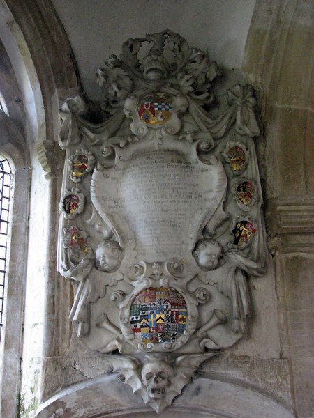
1234:== {{int:filedesc}} == {{Information |description={{en|1=St Mary's church - wall monument Memorial Sir William Cooke, who died in 1698.
The main features of St Mary's church date from the 14th century; the tower has a parapet and, unusual for Norfolk,
722:"}},"text\/plain":{"en":{"":"geograph.org.uk image ID"}}},"{\"value\":\"704192\",\"type\":\"string\"}":{"text\/html":{"en":{"P7384":"
441:– You must give appropriate credit, provide a link to the license, and indicate if changes were made. You may do so in any reasonable manner, but not in any way that suggests the licensor endorses you or your use.
93:
48:
42:
61:
313:
263:
153:
723:
715:
671:
627:
731:
940:
536:
1131:
1093:
1048:
984:
980:
936:
872:
868:
719:
711:
623:
532:
524:
520:
158:
interesting wall monuments, most of these to the
Gurdons who lived at Letton Hall. The church is kept locked but a key is readily available. For more information see:
528:
830:
739:
735:
727:
667:
516:
1227:
674:"}},"text\/plain":{"en":{"P275":"Creative Commons Attribution-ShareAlike 2.0 Generic"}}}}": -->
742:"}},"text\/plain":{"en":{"P973":"https:\/\/www.geograph.org.uk\/photo\/704192"}}}}": -->
1216:
1211:
52:
37:
765:
697:
653:
323:
273:
800:
358:
1259:
This file contains additional information, probably added from the digital camera or scanner used to create or digitize it.
966:
448:
608:
1145:
1103:
1062:
1025:
998:
950:
913:
886:
778:
749:
637:
601:
586:
573:
840:
808:
793:
681:
546:
505:
1422:
943:"}},"text\/plain":{"en":{"P4082":"Canon PowerShot S3 IS"}}}}": -->
146:
404:
1248:
1262:
If the file has been modified from its original state, some details may not fully reflect the modified file.
137:
1138:"}},"text\/plain":{"en":{"P2151":"8.6 millimetre"}}}}": -->
447:– If you remix, transform, or build upon the material, you must distribute your contributions under the
365:
on the
Geograph website for the photographer's contact details. The copyright on this image is owned by
1354:
1055:"}},"text\/plain":{"en":{"P6757":"0.0125 second"}}}}": -->
539:"}},"text\/plain":{"en":{"P3831":"photographer"}}}}": -->
630:"}},"text\/plain":{"en":{"P6216":"copyrighted"}}}}": -->
991:"}},"text\/plain":{"en":{"P7787":"157 degree"}}}}": -->
879:"}},"text\/plain":{"en":{"P7787":"157 degree"}}}}": -->
101:
218:
150:
1467:
1281:
593:
815:
785:
401:
202:
159:
8:
1495:
345:
329:
279:
149:(c.1630-1708), of Broome Hall in Norfolk. Heraldry see: heraldryinnorfolk.wordpress.com
370:
88:
495:
1271:
1485:
1449:
1393:
1288:
191:
1403:
1317:
181:
1155:
1113:
1072:
1008:
960:
896:
850:
759:
691:
647:
556:
1505:
350:
1500:
Flash did not fire, compulsory flash suppression, red-eye reduction mode
362:
1298:
1184:
Click on a date/time to view the file as it appeared at that time.
315:
265:
154:
File:Arms SirWilliamCook 2ndBaronet
CranworthChurch Norfolk.svg
126:
St Mary's church - wall monument - geograph.org.uk - 704192.jpg
300:
52° 36′ 06″ N, 0° 55′ 38″ E
250:
52° 36′ 06″ N, 0° 55′ 37″ E
170:
76:
160:
http://www.norfolkchurches.co.uk/cranworth/cranworth.htm
145:
St Mary's Church, Cranworth, Norfolk, mural monument to
489:
Add a one-line explanation of what this file represents
1242:
1182:
100:
Commons is a freely licensed media file repository.
698:
Creative
Commons Attribution-ShareAlike 2.0 Generic
672:
Creative
Commons Attribution-ShareAlike 2.0 Generic
66:(480 × 640 pixels, file size: 172 KB, MIME type:
458:https://creativecommons.org/licenses/by-sa/2.0
81:
529:https:\/\/www.geograph.org.uk\/profile\/14840
464:Creative Commons Attribution-Share Alike 2.0
382:
166:
123:
740:https:\/\/www.geograph.org.uk\/photo\/704192
187:
176:
14:
1135:
1052:
988:
876:
424:– to copy, distribute and transmit the work
594:https://www.geograph.org.uk/profile/14840
816:https://www.geograph.org.uk/photo/704192
136:
322:View this and other nearby images on:
272:View this and other nearby images on:
225:
112:
369:and is licensed for reuse under the
290:
240:
1244:The following page uses this file:
1175:
405:Attribution-Share Alike 2.0 Generic
393:
388:
373:Attribution-ShareAlike 2.0 license.
13:
1257:
494:
488:
379:
356:
130:
113:
59:
1554:
1264:
493:
1308:Date and time of data generation
887:coordinates of the point of view
869:coordinates of the point of view
479:
435:Under the following conditions:
400:This file is licensed under the
392:
387:
381:
349:
328:
314:
306:
278:
264:
256:
233:St Mary's church - wall monument
214:St Mary's church - wall monument
80:
21:
476:
147:w:Sir William Cook, 2nd Baronet
131:
1179:
766:file available on the internet
716:file available on the internet
475:
357:This image was taken from the
26:
1:
1249:Sir William Cook, 2nd Baronet
999:coordinates of depicted place
981:coordinates of depicted place
31:
1239:
801:Geograph Britain and Ireland
732:Geograph Britain and Ireland
602:object of statement has role
533:object of statement has role
501:Items portrayed in this file
341:
305:
255:
7:
1531:Focal plane resolution unit
1433:Date and time of digitizing
1254:
10:
1559:
1542:One-chip color area sensor
1355:Adobe Photoshop CS Windows
1014:52°36'5.69"N, 0°55'37.56"E
902:52°36'6.37"N, 0°55'36.84"E
449:same or compatible license
120:
115:
1361:File change date and time
1176:
231:Evelyn Simak /
212:Evelyn Simak /
16:
1523:Focal plane Y resolution
1515:Focal plane X resolution
779:geograph.org.uk image ID
720:geograph.org.uk image ID
478:
415:
87:This is a file from the
36:
1436:12:19, 25 February 2008
1377:Custom image processing
1364:18:02, 25 February 2008
1311:12:19, 25 February 2008
1233:
1212:23:08, 18 February 2011
203:required by the license
169:
91:. Information from its
1441:Image compression mode
363:this photograph's page
334:52.601580; 0.927100
284:52.601770; 0.926900
142:
94:description page there
41:Size of this preview:
1480:3.34375 APEX (f/3.19)
1477:Maximum land aperture
1335:Horizontal resolution
1282:Canon PowerShot S3 IS
967:Canon PowerShot S3 IS
941:Canon PowerShot S3 IS
140:
141:Detail from monument
1369:Y and C positioning
1343:Vertical resolution
1268:Camera manufacturer
430:– to adapt the work
152:. For heraldry see
47:Other resolutions:
1414:Scene capture type
1398:Auto white balance
574:author name string
521:author name string
143:
1546:
1545:
1293:1/80 sec (0.0125)
1237:
1137:
1054:
990:
878:
682:copyright license
668:copyright license
487:
378:
377:
361:collection. See
339:
338:
289:
288:
238:
237:
206:
109:
108:
89:Wikimedia Commons
1550:
1526:2,844.4444444444
1518:2,840.2366863905
1265:
1224:
1186:
1164:
1081:
1036:
1035:
1030:
924:
923:
918:
856:25 February 2008
818:
813:
809:described at URL
803:
798:
788:
783:
736:described at URL
638:copyright status
624:copyright status
611:
606:
596:
591:
581:
578:
485:
471:
468:
465:
462:
459:
451:as the original.
413:
402:Creative Commons
396:
395:
391:
390:
385:
384:
371:Creative Commons
359:Geograph project
353:
346:
335:
332:
318:
317:
311:
310:
309:
303:
302:
291:
285:
282:
268:
267:
261:
260:
259:
253:
252:
241:
200:
172:
171:25 February 2008
135:
127:
121:
105:
84:
83:
77:
71:
69:
56:
53:480 × 640 pixels
49:180 × 240 pixels
43:450 × 600 pixels
1558:
1557:
1553:
1552:
1551:
1549:
1548:
1547:
1253:
1238:
1230:
1222:
1178:
1177:
1174:
1173:
1172:
1171:
1170:
1169:
1168:
1167:
1165:
1162:
1152:
1151:
1150:
1148:
1129:
1128:
1127:
1126:
1125:
1124:
1123:
1122:
1120:
1110:
1109:
1108:
1106:
1091:
1090:
1089:
1088:
1087:
1086:
1085:
1084:
1082:
1079:
1069:
1068:
1067:
1065:
1046:
1045:
1044:
1043:
1042:
1041:
1040:
1039:
1038:
1037:
1033:
1031:
1028:
1019:
1018:
1017:
1015:
1005:
1004:
1003:
1001:
978:
977:
976:
975:
974:
973:
972:
971:
969:
957:
956:
955:
953:
934:
933:
932:
931:
930:
929:
928:
927:
926:
925:
921:
919:
916:
907:
906:
905:
903:
893:
892:
891:
889:
866:
865:
864:
863:
862:
861:
860:
859:
857:
847:
846:
845:
843:
828:
827:
826:
825:
824:
823:
822:
821:
820:
819:
814:
811:
805:
804:
799:
796:
790:
789:
784:
781:
772:
771:
770:
768:
756:
755:
754:
752:
709:
708:
707:
706:
705:
704:
703:
702:
700:
688:
687:
686:
684:
665:
664:
663:
662:
661:
660:
659:
658:
656:
644:
643:
642:
640:
621:
620:
619:
618:
617:
616:
615:
614:
613:
612:
607:
604:
598:
597:
592:
589:
583:
582:
579:
576:
567:
566:
565:
563:
553:
552:
551:
549:
514:
513:
512:
511:
510:
508:
492:
491:
490:
473:
472:
469:
466:
463:
460:
457:
456:
414:
411:
408:
397:
374:
344:
333:
307:
298:
297:
294:Object location
283:
257:
248:
247:
244:Camera location
239:
228:
221:
209:
182:geograph.org.uk
162:
125:
118:
111:
110:
99:
98:
97:is shown below.
73:
67:
65:
58:
57:
46:
12:
11:
5:
1556:
1544:
1543:
1540:
1539:Sensing method
1536:
1535:
1532:
1528:
1527:
1524:
1520:
1519:
1516:
1512:
1511:
1508:
1502:
1501:
1498:
1492:
1491:
1488:
1482:
1481:
1478:
1474:
1473:
1470:
1464:
1463:
1460:
1456:
1455:
1452:
1446:
1445:
1442:
1438:
1437:
1434:
1430:
1429:
1426:
1419:
1418:
1415:
1411:
1410:
1407:
1400:
1399:
1396:
1390:
1389:
1386:
1382:
1381:
1380:Normal process
1378:
1374:
1373:
1370:
1366:
1365:
1362:
1358:
1357:
1352:
1348:
1347:
1344:
1340:
1339:
1336:
1332:
1331:
1328:
1324:
1323:
1320:
1313:
1312:
1309:
1305:
1304:
1301:
1295:
1294:
1291:
1285:
1284:
1279:
1275:
1274:
1269:
1256:
1252:
1251:
1241:
1236:
1235:
1232:
1228:
1225:
1219:
1214:
1209:
1205:
1204:
1201:
1198:
1195:
1192:
1189:
1181:
1166:
1160:
1158:
1157:
1156:
1154:
1153:
1149:
1144:
1142:
1141:
1140:
1139:
1133:
1121:
1118:
1116:
1115:
1114:
1112:
1111:
1107:
1102:
1100:
1099:
1098:
1097:
1095:
1083:
1077:
1075:
1074:
1073:
1071:
1070:
1066:
1061:
1059:
1058:
1057:
1056:
1050:
1024:
1023:
1022:
1021:
1020:
1016:
1013:
1011:
1010:
1009:
1007:
1006:
1002:
997:
995:
994:
993:
992:
986:
982:
970:
965:
963:
962:
961:
959:
958:
954:
949:
947:
946:
945:
944:
942:
938:
912:
911:
910:
909:
908:
904:
901:
899:
898:
897:
895:
894:
890:
885:
883:
882:
881:
880:
874:
870:
858:
855:
853:
852:
851:
849:
848:
844:
839:
837:
836:
835:
834:
832:
807:
806:
792:
791:
777:
776:
775:
774:
773:
769:
764:
762:
761:
760:
758:
757:
753:
750:source of file
748:
746:
745:
744:
743:
741:
737:
733:
729:
725:
721:
717:
713:
712:source of file
701:
696:
694:
693:
692:
690:
689:
685:
680:
678:
677:
676:
675:
673:
669:
657:
652:
650:
649:
648:
646:
645:
641:
636:
634:
633:
632:
631:
629:
625:
600:
599:
585:
584:
572:
571:
570:
569:
568:
564:
561:
559:
558:
557:
555:
554:
550:
545:
543:
542:
541:
540:
538:
534:
530:
526:
522:
518:
509:
504:
502:
499:
498:
497:
496:
484:
483:
480:
477:
455:
454:
453:
452:
442:
433:
432:
431:
425:
418:You are free:
409:
399:
398:
380:
376:
375:
354:
343:
340:
337:
336:
326:
320:
295:
287:
286:
276:
270:
245:
236:
235:
229:
226:
223:
222:
217:
210:
207:
195:
194:
189:
185:
184:
178:
174:
173:
168:
164:
163:
128:
119:
117:
114:
107:
106:
85:
75:
74:
40:
35:
34:
29:
24:
19:
9:
6:
4:
3:
2:
1555:
1541:
1538:
1537:
1533:
1530:
1529:
1525:
1522:
1521:
1517:
1514:
1513:
1509:
1507:
1504:
1503:
1499:
1497:
1494:
1493:
1489:
1487:
1486:Metering mode
1484:
1483:
1479:
1476:
1475:
1471:
1469:
1468:Exposure bias
1466:
1465:
1461:
1459:APEX aperture
1458:
1457:
1453:
1451:
1450:Shutter speed
1448:
1447:
1443:
1440:
1439:
1435:
1432:
1431:
1427:
1424:
1421:
1420:
1416:
1413:
1412:
1408:
1405:
1402:
1401:
1397:
1395:
1394:White balance
1392:
1391:
1388:Auto exposure
1387:
1385:Exposure mode
1384:
1383:
1379:
1376:
1375:
1371:
1368:
1367:
1363:
1360:
1359:
1356:
1353:
1351:Software used
1350:
1349:
1345:
1342:
1341:
1337:
1334:
1333:
1329:
1326:
1325:
1321:
1319:
1315:
1314:
1310:
1307:
1306:
1302:
1300:
1297:
1296:
1292:
1290:
1289:Exposure time
1287:
1286:
1283:
1280:
1277:
1276:
1273:
1270:
1267:
1266:
1263:
1260:
1250:
1247:
1246:
1245:
1231:
1226:
1220:
1218:
1215:
1213:
1210:
1207:
1206:
1202:
1199:
1196:
1193:
1190:
1188:
1187:
1185:
1159:
1147:
1143:
1117:
1105:
1101:
1076:
1064:
1063:exposure time
1060:
1049:exposure time
1027:
1012:
1000:
996:
968:
964:
952:
951:captured with
948:
937:captured with
915:
900:
888:
884:
854:
842:
838:
817:
810:
802:
795:
787:
780:
767:
763:
751:
747:
699:
695:
683:
679:
655:
651:
639:
635:
610:
603:
595:
588:
575:
560:
548:
544:
507:
503:
500:
481:
474:
461:CC BY-SA 2.0
450:
446:
443:
440:
437:
436:
434:
429:
426:
423:
420:
419:
417:
416:
410:Attribution:
406:
403:
386:
372:
368:
364:
360:
355:
352:
348:
347:
331:
327:
325:
324:OpenStreetMap
321:
319:
301:
296:
293:
292:
281:
277:
275:
274:OpenStreetMap
271:
269:
251:
246:
243:
242:
234:
230:
224:
220:
216: /
215:
211:
204:
199:
197:
196:
193:
190:
186:
183:
179:
175:
165:
161:
156:
155:
151:
148:
139:
134:
129:
122:
103:
96:
95:
90:
86:
79:
78:
72:
63:
62:Original file
54:
50:
44:
39:
33:
30:
28:
25:
23:
20:
18:
15:
1404:Digital zoom
1318:focal length
1278:Camera model
1261:
1258:
1243:
1183:
1180:File history
1146:focal length
1132:focal length
609:photographer
580:Evelyn Simak
537:photographer
444:
438:
427:
421:
412:Evelyn Simak
367:Evelyn Simak
366:
304:
254:
232:
219:CC BY-SA 2.0
213:
192:Evelyn Simak
144:
132:
102:You can help
92:
60:
22:File history
1506:Color space
1327:Orientation
1229:GeographBot
654:copyrighted
628:copyrighted
445:share alike
439:attribution
198:Attribution
124:Description
1240:File usage
1221:480 × 640
1197:Dimensions
1163:millimetre
1136:millimetre
562:some value
68:image/jpeg
27:File usage
1194:Thumbnail
1191:Date/Time
841:inception
831:inception
342:Licensing
227:InfoField
208:InfoField
133:English:
1417:Standard
1372:Centered
1299:F-number
1255:Metadata
1223:(172 KB)
1104:f-number
1094:f-number
794:operator
728:operator
482:Captions
428:to remix
422:to share
407:license.
32:Metadata
1490:Pattern
1462:3.34375
1425:version
1346:180 dpi
1338:180 dpi
1208:current
1203:Comment
1078:0.0125
1026:heading
985:heading
914:heading
873:heading
547:creator
517:creator
506:depicts
486:English
116:Summary
64:
1534:inches
1454:6.3125
1330:Normal
1322:8.6 mm
1080:second
1053:second
1034:degree
989:degree
922:degree
877:degree
786:704192
724:704192
312:
262:
188:Author
177:Source
1496:Flash
1406:ratio
1316:Lens
1303:f/3.2
1272:Canon
180:From
1510:sRGB
1423:Exif
1200:User
1161:8.6
1032:157
920:157
470:true
467:true
167:Date
17:File
1428:2.2
1119:3.2
587:URL
525:URL
1029::
917::
812::
797::
782::
605::
590::
577::
51:|
45:.
1472:0
1444:3
1409:1
205:)
201:(
104:.
70:)
55:.
Text is available under the Creative Commons Attribution-ShareAlike License. Additional terms may apply.


_heading:157.00&language=en)
_heading:157.00&language=en)
