852:"}},"text\/plain":{"en":{"":"coordinates of the point of view"}}},"{\"value\":{\"latitude\":51.21306,\"longitude\":-3.6734,\"altitude\":null,\"precision\":1.0e-5,\"globe\":\"http:\\\/\\\/www.wikidata.org\\\/entity\\\/Q2\"},\"type\":\"globecoordinate\"}":{"text\/html":{"en":{"P1259":"51\u00b012'47.02"N, 3\u00b040'24.24"W"}},"text\/plain":{"en":{"P1259":"51\u00b012'47.02\"N, 3\u00b040'24.24\"W"}}},"{\"value\":{\"entity-type\":\"property\",\"numeric-id\":7787,\"id\":\"P7787\"},\"type\":\"wikibase-entityid\"}":{"text\/html":{"en":{"":"
920:"}},"text\/plain":{"en":{"":"coordinates of depicted place"}}},"{\"value\":{\"latitude\":51.21323,\"longitude\":-3.6738,\"altitude\":null,\"precision\":1.0e-5,\"globe\":\"http:\\\/\\\/www.wikidata.org\\\/entity\\\/Q2\"},\"type\":\"globecoordinate\"}":{"text\/html":{"en":{"P9149":"51\u00b012'47.63"N, 3\u00b040'25.68"W"}},"text\/plain":{"en":{"P9149":"51\u00b012'47.63\"N, 3\u00b040'25.68\"W"}}},"{\"value\":{\"entity-type\":\"property\",\"numeric-id\":7787,\"id\":\"P7787\"},\"type\":\"wikibase-entityid\"}":{"text\/html":{"en":{"":"
504:"}},"text\/plain":{"en":{"":"author name string"}}},"{\"value\":\"Rod Allday\",\"type\":\"string\"}":{"text\/html":{"en":{"P2093":"Rod Allday"}},"text\/plain":{"en":{"P2093":"Rod Allday"}}},"{\"value\":{\"entity-type\":\"property\",\"numeric-id\":2699,\"id\":\"P2699\"},\"type\":\"wikibase-entityid\"}":{"text\/html":{"en":{"":"
814:"}},"text\/plain":{"en":{"":"inception"}}},"{\"value\":{\"time\":\"+2009-04-03T00:00:00Z\",\"timezone\":0,\"before\":0,\"after\":0,\"precision\":11,\"calendarmodel\":\"http:\\\/\\\/www.wikidata.org\\\/entity\\\/Q1985727\"},\"type\":\"time\"}":{"text\/html":{"en":{"P571":"3 April 2009"}},"text\/plain":{"en":{"P571":"3 April 2009"}}}}": -->
691:
297:
247:
289:
239:
916:
261:
332:
370:
43:
375:
87:
512:"}},"text\/plain":{"en":{"P2699":"https:\/\/www.geograph.org.uk\/profile\/22976"}}},"{\"value\":{\"entity-type\":\"property\",\"numeric-id\":3831,\"id\":\"P3831\"},\"type\":\"wikibase-entityid\"}":{"text\/html":{"en":{"":"
699:"}},"text\/plain":{"en":{"P7482":"file available on the internet"}}},"{\"value\":{\"entity-type\":\"property\",\"numeric-id\":137,\"id\":\"P137\"},\"type\":\"wikibase-entityid\"}":{"text\/html":{"en":{"":"
707:"}},"text\/plain":{"en":{"P137":"Geograph Britain and Ireland"}}},"{\"value\":{\"entity-type\":\"property\",\"numeric-id\":7384,\"id\":\"P7384\"},\"type\":\"wikibase-entityid\"}":{"text\/html":{"en":{"":"
516:"}},"text\/plain":{"en":{"":"object of statement has role"}}},"{\"value\":{\"entity-type\":\"item\",\"numeric-id\":33231,\"id\":\"Q33231\"},\"type\":\"wikibase-entityid\"}":{"text\/html":{"en":{"P3831":"
651:"}},"text\/plain":{"en":{"":"copyright license"}}},"{\"value\":{\"entity-type\":\"item\",\"numeric-id\":19068220,\"id\":\"Q19068220\"},\"type\":\"wikibase-entityid\"}":{"text\/html":{"en":{"P275":"
607:"}},"text\/plain":{"en":{"":"copyright status"}}},"{\"value\":{\"entity-type\":\"item\",\"numeric-id\":50423863,\"id\":\"Q50423863\"},\"type\":\"wikibase-entityid\"}":{"text\/html":{"en":{"P6216":"
695:"}},"text\/plain":{"en":{"":"source of file"}}},"{\"value\":{\"entity-type\":\"item\",\"numeric-id\":74228490,\"id\":\"Q74228490\"},\"type\":\"wikibase-entityid\"}":{"text\/html":{"en":{"P7482":"
924:"}},"text\/plain":{"en":{"":"heading"}}},"{\"value\":{\"amount\":\"+292\",\"unit\":\"http:\\\/\\\/www.wikidata.org\\\/entity\\\/Q28390\"},\"type\":\"quantity\"}":{"text\/html":{"en":{"P7787":"292
856:"}},"text\/plain":{"en":{"":"heading"}}},"{\"value\":{\"amount\":\"+292\",\"unit\":\"http:\\\/\\\/www.wikidata.org\\\/entity\\\/Q28390\"},\"type\":\"quantity\"}":{"text\/html":{"en":{"P7787":"292
703:"}},"text\/plain":{"en":{"":"operator"}}},"{\"value\":{\"entity-type\":\"item\",\"numeric-id\":1503119,\"id\":\"Q1503119\"},\"type\":\"wikibase-entityid\"}":{"text\/html":{"en":{"P137":"
715:"}},"text\/plain":{"en":{"P7384":"1239561"}}},"{\"value\":{\"entity-type\":\"property\",\"numeric-id\":973,\"id\":\"P973\"},\"type\":\"wikibase-entityid\"}":{"text\/html":{"en":{"":"
500:"}},"text\/plain":{"en":{"":"creator"}}},"{\"value\":{\"entity-type\":\"property\",\"numeric-id\":2093,\"id\":\"P2093\"},\"type\":\"wikibase-entityid\"}":{"text\/html":{"en":{"":"
1026:
603:
711:"}},"text\/plain":{"en":{"":"geograph.org.uk image ID"}}},"{\"value\":\"1239561\",\"type\":\"string\"}":{"text\/html":{"en":{"P7384":"
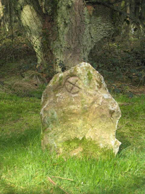
1043:== {{int:filedesc}} == {{Information |description={{en|1=The Culbone Stone The Culbone Stone, which was discovered in 1940, is a scheduled ancient monument. The style of the incised wheeled cross suggests that it dates from the C7th. The cross can be re
230:
141:
The
Culbone Stone The Culbone Stone, which was discovered in 1940, is a scheduled ancient monument. The style of the incised wheeled cross suggests that it dates from the C7th. The cross can be reached by a permissive path from the Worthy Toll
1072:
422:– You must give appropriate credit, provide a link to the license, and indicate if changes were made. You may do so in any reasonable manner, but not in any way that suggests the licensor endorses you or your use.
294:
244:
53:
47:
712:
696:
652:
608:
98:
704:
66:
517:
921:
917:
853:
849:
708:
692:
604:
513:
505:
501:
720:
509:
811:
716:
700:
648:
497:
1067:
1036:
655:"}},"text\/plain":{"en":{"P275":"Creative Commons Attribution-ShareAlike 2.0 Generic"}}}}": -->
723:"}},"text\/plain":{"en":{"P973":"https:\/\/www.geograph.org.uk\/photo\/1239561"}}}}": -->
746:
678:
634:
304:
254:
766:
339:
1103:
This file contains additional information, probably added from the digital camera or scanner used to create or digitize it.
429:
589:
962:
935:
894:
867:
774:
730:
618:
582:
567:
554:
821:
789:
759:
662:
527:
486:
1025:
1020:
57:
42:
385:
1106:
If the file has been modified from its original state, some details may not fully reflect the modified file.
428:– If you remix, transform, or build upon the material, you must distribute your contributions under the
346:
on the
Geograph website for the photographer's contact details. The copyright on this image is owned by
520:"}},"text\/plain":{"en":{"P3831":"photographer"}}}}": -->
611:"}},"text\/plain":{"en":{"P6216":"copyrighted"}}}}": -->
928:"}},"text\/plain":{"en":{"P7787":"292 degree"}}}}": -->
860:"}},"text\/plain":{"en":{"P7787":"292 degree"}}}}": -->
106:
796:
781:
574:
1090:
382:
183:
8:
326:
310:
260:
1073:
Knowledge:WikiProject
Historic sites/Images of listed buildings in England without ID
351:
93:
476:
199:
1062:
172:
162:
945:
877:
831:
740:
672:
628:
537:
331:
343:
993:
Click on a date/time to view the file as it appeared at that time.
1057:
296:
246:
281:
51° 12′ 48″ N, 3° 40′ 26″ W
231:
51° 12′ 47″ N, 3° 40′ 24″ W
151:
81:
470:
Add a one-line explanation of what this file represents
1051:
1081:
991:
105:
Commons is a freely licensed media file repository.
679:
Creative
Commons Attribution-ShareAlike 2.0 Generic
653:
Creative
Commons Attribution-ShareAlike 2.0 Generic
1068:List of scheduled monuments in West Somerset (H–Z)
131:The Culbone Stone - geograph.org.uk - 1239561.jpg
71:(480 × 640 pixels, file size: 120 KB, MIME type:
439:https://creativecommons.org/licenses/by-sa/2.0
86:
721:https:\/\/www.geograph.org.uk\/photo\/1239561
510:https:\/\/www.geograph.org.uk\/profile\/22976
445:Creative Commons Attribution-Share Alike 2.0
363:
147:
128:
168:
157:
14:
925:
857:
405:– to copy, distribute and transmit the work
1091:Liste des sites mégalithiques du Somerset
1083:The following other wikis use this file:
797:https://www.geograph.org.uk/photo/1239561
575:https://www.geograph.org.uk/profile/22976
303:View this and other nearby images on:
253:View this and other nearby images on:
1053:The following 4 pages use this file:
206:
117:
350:and is licensed for reuse under the
271:
221:
984:
386:Attribution-Share Alike 2.0 Generic
374:
369:
354:Attribution-ShareAlike 2.0 license.
13:
1101:
475:
469:
360:
337:
135:
118:
64:
1127:
1108:
474:
868:coordinates of the point of view
850:coordinates of the point of view
460:
416:Under the following conditions:
381:This file is licensed under the
373:
368:
362:
330:
309:
295:
287:
259:
245:
237:
85:
31:
21:
457:
136:
1078:
988:
747:file available on the internet
697:file available on the internet
456:
338:This image was taken from the
26:
1:
936:coordinates of depicted place
918:coordinates of depicted place
36:
1048:
767:Geograph Britain and Ireland
705:Geograph Britain and Ireland
583:object of statement has role
514:object of statement has role
482:Items portrayed in this file
322:
286:
236:
7:
1098:
951:51°12'47.63"N, 3°40'25.68"W
883:51°12'47.02"N, 3°40'24.24"W
10:
1132:
1087:Usage on fr.wikipedia.org
430:same or compatible license
125:
120:
985:
16:
775:geograph.org.uk image ID
709:geograph.org.uk image ID
459:
396:
92:This is a file from the
41:
1042:
1021:14:30, 26 February 2011
212:Rod Allday /
193:Rod Allday /
184:required by the license
150:
96:. Information from its
344:this photograph's page
315:51.213230; -3.673800
265:51.213060; -3.673400
99:description page there
46:Size of this preview:
411:– to adapt the work
52:Other resolutions:
555:author name string
502:author name string
1119:
1118:
1079:Global file usage
1046:
927:
859:
663:copyright license
649:copyright license
468:
359:
358:
342:collection. See
320:
319:
270:
269:
219:
218:
214:The Culbone Stone
195:The Culbone Stone
187:
114:
113:
94:Wikimedia Commons
32:Global file usage
1123:
1109:
1033:
995:
973:
972:
967:
905:
904:
899:
799:
794:
790:described at URL
784:
779:
769:
764:
717:described at URL
619:copyright status
605:copyright status
592:
587:
577:
572:
562:
559:
466:
452:
449:
446:
443:
440:
432:as the original.
394:
383:Creative Commons
377:
376:
372:
371:
366:
365:
352:Creative Commons
340:Geograph project
334:
327:
316:
313:
299:
298:
292:
291:
290:
284:
283:
272:
266:
263:
249:
248:
242:
241:
240:
234:
233:
222:
181:
153:
140:
132:
126:
110:
89:
88:
82:
76:
74:
61:
58:480 × 640 pixels
54:180 × 240 pixels
48:450 × 600 pixels
1131:
1130:
1126:
1125:
1124:
1122:
1121:
1120:
1097:
1077:
1047:
1039:
1031:
987:
986:
983:
982:
981:
980:
979:
978:
977:
976:
975:
974:
970:
968:
965:
956:
955:
954:
952:
942:
941:
940:
938:
915:
914:
913:
912:
911:
910:
909:
908:
907:
906:
902:
900:
897:
888:
887:
886:
884:
874:
873:
872:
870:
847:
846:
845:
844:
843:
842:
841:
840:
838:
828:
827:
826:
824:
809:
808:
807:
806:
805:
804:
803:
802:
801:
800:
795:
792:
786:
785:
780:
777:
771:
770:
765:
762:
753:
752:
751:
749:
737:
736:
735:
733:
690:
689:
688:
687:
686:
685:
684:
683:
681:
669:
668:
667:
665:
646:
645:
644:
643:
642:
641:
640:
639:
637:
625:
624:
623:
621:
602:
601:
600:
599:
598:
597:
596:
595:
594:
593:
588:
585:
579:
578:
573:
570:
564:
563:
560:
557:
548:
547:
546:
544:
534:
533:
532:
530:
495:
494:
493:
492:
491:
489:
473:
472:
471:
454:
453:
450:
447:
444:
441:
438:
437:
395:
392:
389:
378:
355:
325:
314:
288:
279:
278:
275:Object location
264:
238:
229:
228:
225:Camera location
220:
209:
202:
190:
163:geograph.org.uk
143:
130:
123:
116:
115:
104:
103:
102:is shown below.
78:
72:
70:
63:
62:
51:
12:
11:
5:
1129:
1117:
1116:
1113:
1100:
1096:
1095:
1094:
1093:
1080:
1076:
1075:
1070:
1065:
1060:
1050:
1045:
1044:
1041:
1037:
1034:
1028:
1023:
1018:
1014:
1013:
1010:
1007:
1004:
1001:
998:
990:
961:
960:
959:
958:
957:
953:
950:
948:
947:
946:
944:
943:
939:
934:
932:
931:
930:
929:
923:
919:
893:
892:
891:
890:
889:
885:
882:
880:
879:
878:
876:
875:
871:
866:
864:
863:
862:
861:
855:
851:
839:
836:
834:
833:
832:
830:
829:
825:
820:
818:
817:
816:
815:
813:
788:
787:
773:
772:
758:
757:
756:
755:
754:
750:
745:
743:
742:
741:
739:
738:
734:
731:source of file
729:
727:
726:
725:
724:
722:
718:
714:
710:
706:
702:
698:
694:
693:source of file
682:
677:
675:
674:
673:
671:
670:
666:
661:
659:
658:
657:
656:
654:
650:
638:
633:
631:
630:
629:
627:
626:
622:
617:
615:
614:
613:
612:
610:
606:
581:
580:
566:
565:
553:
552:
551:
550:
549:
545:
542:
540:
539:
538:
536:
535:
531:
526:
524:
523:
522:
521:
519:
515:
511:
507:
503:
499:
490:
485:
483:
480:
479:
478:
477:
465:
464:
461:
458:
436:
435:
434:
433:
423:
414:
413:
412:
406:
399:You are free:
390:
380:
379:
361:
357:
356:
335:
324:
321:
318:
317:
307:
301:
276:
268:
267:
257:
251:
226:
217:
216:
210:
207:
204:
203:
198:
191:
188:
176:
175:
170:
166:
165:
159:
155:
154:
149:
145:
144:
133:
124:
122:
119:
112:
111:
90:
80:
79:
45:
40:
39:
34:
29:
24:
19:
9:
6:
4:
3:
2:
1128:
1114:
1111:
1110:
1107:
1104:
1092:
1089:
1088:
1086:
1085:
1084:
1074:
1071:
1069:
1066:
1064:
1063:Culbone Stone
1061:
1059:
1056:
1055:
1054:
1040:
1035:
1029:
1027:
1024:
1022:
1019:
1016:
1015:
1011:
1008:
1005:
1002:
999:
997:
996:
994:
964:
949:
937:
933:
896:
881:
869:
865:
835:
823:
819:
798:
791:
783:
776:
768:
761:
748:
744:
732:
728:
680:
676:
664:
660:
636:
632:
620:
616:
591:
584:
576:
569:
556:
541:
529:
525:
488:
484:
481:
462:
455:
442:CC BY-SA 2.0
431:
427:
424:
421:
418:
417:
415:
410:
407:
404:
401:
400:
398:
397:
391:Attribution:
387:
384:
367:
353:
349:
345:
341:
336:
333:
329:
328:
312:
308:
306:
305:OpenStreetMap
302:
300:
282:
277:
274:
273:
262:
258:
256:
255:OpenStreetMap
252:
250:
232:
227:
224:
223:
215:
211:
205:
201:
197: /
196:
192:
185:
180:
178:
177:
174:
171:
167:
164:
160:
156:
146:
139:
134:
127:
108:
101:
100:
95:
91:
84:
83:
77:
68:
67:Original file
59:
55:
49:
44:
38:
35:
33:
30:
28:
25:
23:
20:
18:
15:
1105:
1102:
1082:
1052:
992:
989:File history
837:3 April 2009
590:photographer
518:photographer
425:
419:
408:
402:
347:
285:
235:
213:
200:CC BY-SA 2.0
194:
152:3 April 2009
137:
107:You can help
97:
65:
22:File history
1038:GeographBot
635:copyrighted
609:copyrighted
426:share alike
420:attribution
179:Attribution
129:Description
1112:_error
1049:File usage
1030:480 × 640
1006:Dimensions
561:Rod Allday
543:some value
393:Rod Allday
348:Rod Allday
173:Rod Allday
73:image/jpeg
27:File usage
1003:Thumbnail
1000:Date/Time
822:inception
812:inception
323:Licensing
208:InfoField
189:InfoField
138:English:
1099:Metadata
1032:(120 KB)
760:operator
701:operator
463:Captions
409:to remix
403:to share
388:license.
37:Metadata
1058:Culbone
1017:current
1012:Comment
963:heading
922:heading
895:heading
854:heading
782:1239561
713:1239561
528:creator
498:creator
487:depicts
467:English
121:Summary
69:
971:degree
926:degree
903:degree
858:degree
293:
243:
169:Author
158:Source
161:From
142:Road.
1009:User
969:292
901:292
451:true
448:true
148:Date
17:File
568:URL
506:URL
966::
898::
793::
778::
763::
586::
571::
558::
56:|
50:.
1115:0
186:)
182:(
109:.
75:)
60:.
Text is available under the Creative Commons Attribution-ShareAlike License. Additional terms may apply.
_heading:292.00&language=en)
_heading:292.00&language=en)
