706:"}},"text\/plain":{"en":{"":"coordinates of the point of view"}}},"{\"value\":{\"latitude\":51.36949,\"longitude\":0.3606,\"altitude\":null,\"precision\":1.0e-5,\"globe\":\"http:\\\/\\\/www.wikidata.org\\\/entity\\\/Q2\"},\"type\":\"globecoordinate\"}":{"text\/html":{"en":{"P1259":"51\u00b022'10.16"N, 0\u00b021'38.16"E"}},"text\/plain":{"en":{"P1259":"51\u00b022'10.16\"N, 0\u00b021'38.16\"E"}}},"{\"value\":{\"entity-type\":\"property\",\"numeric-id\":7787,\"id\":\"P7787\"},\"type\":\"wikibase-entityid\"}":{"text\/html":{"en":{"":"
931:"}},"text\/plain":{"en":{"":"coordinates of depicted place"}}},"{\"value\":{\"latitude\":51.36932,\"longitude\":0.3599,\"altitude\":null,\"precision\":1.0e-5,\"globe\":\"http:\\\/\\\/www.wikidata.org\\\/entity\\\/Q2\"},\"type\":\"globecoordinate\"}":{"text\/html":{"en":{"P9149":"51\u00b022'9.55"N, 0\u00b021'35.64"E"}},"text\/plain":{"en":{"P9149":"51\u00b022'9.55\"N, 0\u00b021'35.64\"E"}}},"{\"value\":{\"entity-type\":\"property\",\"numeric-id\":7787,\"id\":\"P7787\"},\"type\":\"wikibase-entityid\"}":{"text\/html":{"en":{"":"
515:"}},"text\/plain":{"en":{"":"author name string"}}},"{\"value\":\"David Anstiss\",\"type\":\"string\"}":{"text\/html":{"en":{"P2093":"David Anstiss"}},"text\/plain":{"en":{"P2093":"David Anstiss"}}},"{\"value\":{\"entity-type\":\"property\",\"numeric-id\":3831,\"id\":\"P3831\"},\"type\":\"wikibase-entityid\"}":{"text\/html":{"en":{"":"
774:"}},"text\/plain":{"en":{"":"inception"}}},"{\"value\":{\"time\":\"+2009-01-07T00:00:00Z\",\"timezone\":0,\"before\":0,\"after\":0,\"precision\":11,\"calendarmodel\":\"http:\\\/\\\/www.wikidata.org\\\/entity\\\/Q1985727\"},\"type\":\"time\"}":{"text\/html":{"en":{"P571":"7 January 2009"}},"text\/plain":{"en":{"P571":"7 January 2009"}}}}": -->
808:
281:
231:
273:
223:
927:
245:
316:
354:
359:
72:
816:"}},"text\/plain":{"en":{"P7482":"file available on the internet"}}},"{\"value\":{\"entity-type\":\"property\",\"numeric-id\":7384,\"id\":\"P7384\"},\"type\":\"wikibase-entityid\"}":{"text\/html":{"en":{"":"
519:"}},"text\/plain":{"en":{"":"object of statement has role"}}},"{\"value\":{\"entity-type\":\"item\",\"numeric-id\":33231,\"id\":\"Q33231\"},\"type\":\"wikibase-entityid\"}":{"text\/html":{"en":{"P3831":"
832:"}},"text\/plain":{"en":{"P137":"Geograph Britain and Ireland"}}},"{\"value\":{\"entity-type\":\"property\",\"numeric-id\":973,\"id\":\"P973\"},\"type\":\"wikibase-entityid\"}":{"text\/html":{"en":{"":"
999:"}},"text\/plain":{"en":{"":"media type"}}},"{\"value\":\"image\\\/jpeg\",\"type\":\"string\"}":{"text\/html":{"en":{"P1163":"image\/jpeg"}},"text\/plain":{"en":{"P1163":"image\/jpeg"}}}}": -->
662:"}},"text\/plain":{"en":{"":"copyright license"}}},"{\"value\":{\"entity-type\":\"item\",\"numeric-id\":19068220,\"id\":\"Q19068220\"},\"type\":\"wikibase-entityid\"}":{"text\/html":{"en":{"P275":"
618:"}},"text\/plain":{"en":{"":"copyright status"}}},"{\"value\":{\"entity-type\":\"item\",\"numeric-id\":50423863,\"id\":\"Q50423863\"},\"type\":\"wikibase-entityid\"}":{"text\/html":{"en":{"P6216":"
812:"}},"text\/plain":{"en":{"":"source of file"}}},"{\"value\":{\"entity-type\":\"item\",\"numeric-id\":74228490,\"id\":\"Q74228490\"},\"type\":\"wikibase-entityid\"}":{"text\/html":{"en":{"P7482":"
1075:
523:"}},"text\/plain":{"en":{"P3831":"photographer"}}},"{\"value\":{\"entity-type\":\"property\",\"numeric-id\":2699,\"id\":\"P2699\"},\"type\":\"wikibase-entityid\"}":{"text\/html":{"en":{"":"
464:"}},"text\/plain":{"en":{"":"depicts"}}},"{\"value\":{\"entity-type\":\"item\",\"numeric-id\":26388642,\"id\":\"Q26388642\"},\"type\":\"wikibase-entityid\"}":{"text\/html":{"en":{"P180":"
935:"}},"text\/plain":{"en":{"":"heading"}}},"{\"value\":{\"amount\":\"+247\",\"unit\":\"http:\\\/\\\/www.wikidata.org\\\/entity\\\/Q28390\"},\"type\":\"quantity\"}":{"text\/html":{"en":{"P7787":"247
828:"}},"text\/plain":{"en":{"":"operator"}}},"{\"value\":{\"entity-type\":\"item\",\"numeric-id\":1503119,\"id\":\"Q1503119\"},\"type\":\"wikibase-entityid\"}":{"text\/html":{"en":{"P137":"
710:"}},"text\/plain":{"en":{"":"heading"}}},"{\"value\":{\"amount\":\"+247\",\"unit\":\"http:\\\/\\\/www.wikidata.org\\\/entity\\\/Q28390\"},\"type\":\"quantity\"}":{"text\/html":{"en":{"P7787":"247
824:"}},"text\/plain":{"en":{"P7384":"1119539"}}},"{\"value\":{\"entity-type\":\"property\",\"numeric-id\":137,\"id\":\"P137\"},\"type\":\"wikibase-entityid\"}":{"text\/html":{"en":{"":"
511:"}},"text\/plain":{"en":{"":"creator"}}},"{\"value\":{\"entity-type\":\"property\",\"numeric-id\":2093,\"id\":\"P2093\"},\"type\":\"wikibase-entityid\"}":{"text\/html":{"en":{"":"
995:
264:
820:"}},"text\/plain":{"en":{"":"geograph.org.uk image ID"}}},"{\"value\":\"1119539\",\"type\":\"string\"}":{"text\/html":{"en":{"P7384":"
214:
406:– You must give appropriate credit, provide a link to the license, and indicate if changes were made. You may do so in any reasonable manner, but not in any way that suggests the licensor endorses you or your use.
278:
228:
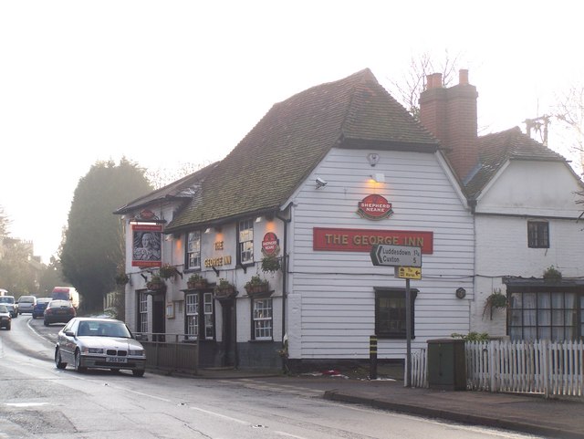
1092:== {{int:filedesc}} == {{Information |description={{en|1=The George Inn, Meopham On A227 Wrotham Road, almost opposite Foxendown Lane.}} |date=2009-01-07 |source=From |author=[http://www.geograph.
83:
51:
821:
813:
663:
619:
465:
829:
520:
996:
932:
928:
817:
809:
707:
703:
615:
524:
516:
512:
837:
528:
833:
825:
771:
659:
508:
461:
1106:
1085:
666:"}},"text\/plain":{"en":{"P275":"Creative Commons Attribution-ShareAlike 2.0 Generic"}}}}": -->
531:"}},"text\/plain":{"en":{"P2699":"https:\/\/www.geograph.org.uk\/profile\/29880"}}}}": -->
840:"}},"text\/plain":{"en":{"P973":"https:\/\/www.geograph.org.uk\/photo\/1119539"}}}}": -->
863:
689:
645:
494:
288:
238:
898:
323:
1137:
This file contains additional information, probably added from the digital camera or scanner used to create or digitize it.
1074:
1069:
413:
42:
585:
1006:
973:
946:
876:
847:
748:
721:
629:
593:
578:
565:
906:
891:
781:
673:
538:
478:
369:
1140:
If the file has been modified from its original state, some details may not fully reflect the modified file.
412:– If you remix, transform, or build upon the material, you must distribute your contributions under the
330:
on the
Geograph website for the photographer's contact details. The copyright on this image is owned by
468:"}},"text\/plain":{"en":{"P180":"The George Inn"}}}}": -->
622:"}},"text\/plain":{"en":{"P6216":"copyrighted"}}}}": -->
939:"}},"text\/plain":{"en":{"P7787":"247 degree"}}}}": -->
714:"}},"text\/plain":{"en":{"P7787":"247 degree"}}}}": -->
91:
183:
913:
883:
600:
366:
167:
8:
310:
294:
244:
335:
78:
126:
The George Inn, Meopham On A227 Wrotham Road, almost opposite
Foxendown Lane.
156:
146:
1016:
956:
857:
791:
731:
683:
639:
548:
488:
315:
327:
1042:
Click on a date/time to view the file as it appeared at that time.
280:
230:
265:
51° 22′ 10″ N, 0° 21′ 36″ E
215:
51° 22′ 10″ N, 0° 21′ 38″ E
135:
66:
1107:
A roads in Zone 2 of the Great
Britain numbering scheme
454:
Add a one-line explanation of what this file represents
116:
The George Inn, Meopham - geograph.org.uk - 1119539.jpg
52:
The_George_Inn,_Meopham_-_geograph.org.uk_-_1119539.jpg
1124:
1100:
1115:
1040:
90:
Commons is a freely licensed media file repository.
690:
Creative
Commons Attribution-ShareAlike 2.0 Generic
664:
Creative
Commons Attribution-ShareAlike 2.0 Generic
56:(640 × 481 pixels, file size: 56 KB, MIME type:
423:https://creativecommons.org/licenses/by-sa/2.0
71:
838:https:\/\/www.geograph.org.uk\/photo\/1119539
529:https:\/\/www.geograph.org.uk\/profile\/29880
429:Creative Commons Attribution-Share Alike 2.0
347:
131:
113:
152:
141:
14:
936:
711:
389:– to copy, distribute and transmit the work
1117:The following other wikis use this file:
914:https://www.geograph.org.uk/photo/1119539
601:https://www.geograph.org.uk/profile/29880
287:View this and other nearby images on:
237:View this and other nearby images on:
190:
102:
334:and is licensed for reuse under the
255:
205:
1102:The following page uses this file:
1033:
370:Attribution-Share Alike 2.0 Generic
358:
353:
338:Attribution-ShareAlike 2.0 license.
13:
1135:
459:
453:
344:
321:
120:
103:
49:
1161:
1142:
458:
722:coordinates of the point of view
704:coordinates of the point of view
444:
400:Under the following conditions:
365:This file is licensed under the
357:
352:
346:
314:
293:
279:
271:
243:
229:
221:
70:
31:
21:
441:
121:
46:No higher resolution available.
1112:
1037:
864:file available on the internet
814:file available on the internet
440:
322:This image was taken from the
26:
1:
947:coordinates of depicted place
929:coordinates of depicted place
36:
1097:
899:Geograph Britain and Ireland
830:Geograph Britain and Ireland
579:object of statement has role
517:object of statement has role
474:Items portrayed in this file
306:
270:
220:
7:
1132:
737:51°22'10.16"N, 0°21'38.16"E
10:
1166:
1121:Usage on www.wikidata.org
962:51°22'9.55"N, 0°21'35.64"E
414:same or compatible license
196:David Anstiss /
177:David Anstiss /
110:
105:
1034:
16:
877:geograph.org.uk image ID
818:geograph.org.uk image ID
443:
380:
77:This is a file from the
41:
1091:
1070:22:29, 24 February 2011
198:The George Inn, Meopham
179:The George Inn, Meopham
168:required by the license
134:
81:. Information from its
328:this photograph's page
299:51.369320; 0.359900
249:51.369490; 0.360600
84:description page there
395:– to adapt the work
566:author name string
513:author name string
1153:
1152:
1113:Global file usage
1095:
938:
713:
674:copyright license
660:copyright license
452:
343:
342:
326:collection. See
304:
303:
254:
253:
203:
202:
171:
99:
98:
79:Wikimedia Commons
32:Global file usage
1157:
1143:
1082:
1044:
984:
983:
978:
916:
911:
907:described at URL
901:
896:
886:
881:
834:described at URL
759:
758:
753:
630:copyright status
616:copyright status
603:
598:
588:
583:
573:
570:
450:
436:
433:
430:
427:
424:
416:as the original.
378:
367:Creative Commons
361:
360:
356:
355:
350:
349:
336:Creative Commons
324:Geograph project
318:
311:
300:
297:
283:
282:
276:
275:
274:
268:
267:
256:
250:
247:
233:
232:
226:
225:
224:
218:
217:
206:
165:
137:
125:
117:
111:
95:
74:
73:
67:
61:
59:
1165:
1164:
1160:
1159:
1158:
1156:
1155:
1154:
1131:
1111:
1096:
1088:
1080:
1036:
1035:
1032:
1031:
1030:
1029:
1028:
1027:
1026:
1025:
1023:
1013:
1012:
1011:
1009:
994:
993:
992:
991:
990:
989:
988:
987:
986:
985:
981:
979:
976:
967:
966:
965:
963:
953:
952:
951:
949:
926:
925:
924:
923:
922:
921:
920:
919:
918:
917:
912:
909:
903:
902:
897:
894:
888:
887:
882:
879:
870:
869:
868:
866:
854:
853:
852:
850:
807:
806:
805:
804:
803:
802:
801:
800:
798:
788:
787:
786:
784:
769:
768:
767:
766:
765:
764:
763:
762:
761:
760:
756:
754:
751:
742:
741:
740:
738:
728:
727:
726:
724:
701:
700:
699:
698:
697:
696:
695:
694:
692:
680:
679:
678:
676:
657:
656:
655:
654:
653:
652:
651:
650:
648:
636:
635:
634:
632:
613:
612:
611:
610:
609:
608:
607:
606:
605:
604:
599:
596:
590:
589:
584:
581:
575:
574:
571:
568:
559:
558:
557:
555:
545:
544:
543:
541:
506:
505:
504:
503:
502:
501:
500:
499:
497:
485:
484:
483:
481:
457:
456:
455:
438:
437:
434:
431:
428:
425:
422:
421:
379:
376:
373:
362:
339:
309:
298:
272:
263:
262:
259:Object location
248:
222:
213:
212:
209:Camera location
204:
193:
186:
174:
147:geograph.org.uk
127:
115:
108:
101:
100:
89:
88:
87:is shown below.
63:
57:
55:
48:
47:
12:
11:
5:
1163:
1151:
1150:
1147:
1134:
1130:
1129:
1128:
1127:
1114:
1110:
1109:
1099:
1094:
1093:
1090:
1086:
1083:
1077:
1072:
1067:
1063:
1062:
1059:
1056:
1053:
1050:
1047:
1039:
1024:
1021:
1019:
1018:
1017:
1015:
1014:
1010:
1005:
1003:
1002:
1001:
1000:
998:
972:
971:
970:
969:
968:
964:
961:
959:
958:
957:
955:
954:
950:
945:
943:
942:
941:
940:
934:
930:
905:
904:
890:
889:
875:
874:
873:
872:
871:
867:
862:
860:
859:
858:
856:
855:
851:
848:source of file
846:
844:
843:
842:
841:
839:
835:
831:
827:
823:
819:
815:
811:
810:source of file
799:
797:7 January 2009
796:
794:
793:
792:
790:
789:
785:
780:
778:
777:
776:
775:
773:
747:
746:
745:
744:
743:
739:
736:
734:
733:
732:
730:
729:
725:
720:
718:
717:
716:
715:
709:
705:
693:
688:
686:
685:
684:
682:
681:
677:
672:
670:
669:
668:
667:
665:
661:
649:
644:
642:
641:
640:
638:
637:
633:
628:
626:
625:
624:
623:
621:
617:
592:
591:
577:
576:
564:
563:
562:
561:
560:
556:
553:
551:
550:
549:
547:
546:
542:
537:
535:
534:
533:
532:
530:
526:
522:
518:
514:
510:
498:
495:The George Inn
493:
491:
490:
489:
487:
486:
482:
477:
475:
472:
471:
470:
469:
467:
466:The George Inn
463:
449:
448:
445:
442:
420:
419:
418:
417:
407:
398:
397:
396:
390:
383:You are free:
374:
364:
363:
345:
341:
340:
319:
308:
305:
302:
301:
291:
285:
260:
252:
251:
241:
235:
210:
201:
200:
194:
191:
188:
187:
182:
175:
172:
160:
159:
154:
150:
149:
143:
139:
138:
136:7 January 2009
133:
129:
128:
118:
109:
107:
104:
97:
96:
75:
65:
64:
45:
40:
39:
34:
29:
24:
19:
9:
6:
4:
3:
2:
1162:
1148:
1145:
1144:
1141:
1138:
1126:
1123:
1122:
1120:
1119:
1118:
1108:
1105:
1104:
1103:
1089:
1084:
1078:
1076:
1073:
1071:
1068:
1065:
1064:
1060:
1057:
1054:
1051:
1048:
1046:
1045:
1043:
1020:
1008:
1004:
975:
960:
948:
944:
915:
908:
900:
893:
885:
878:
865:
861:
849:
845:
795:
783:
779:
750:
735:
723:
719:
691:
687:
675:
671:
647:
643:
631:
627:
602:
595:
587:
580:
572:David Anstiss
567:
552:
540:
536:
496:
492:
480:
476:
473:
446:
439:
426:CC BY-SA 2.0
415:
411:
408:
405:
402:
401:
399:
394:
391:
388:
385:
384:
382:
381:
377:David Anstiss
375:Attribution:
371:
368:
351:
337:
333:
332:David Anstiss
329:
325:
320:
317:
313:
312:
296:
292:
290:
289:OpenStreetMap
286:
284:
266:
261:
258:
257:
246:
242:
240:
239:OpenStreetMap
236:
234:
216:
211:
208:
207:
199:
195:
189:
185:
181: /
180:
176:
169:
164:
162:
161:
158:
157:David Anstiss
155:
151:
148:
144:
140:
130:
124:
119:
112:
93:
86:
85:
80:
76:
69:
68:
62:
53:
44:
38:
35:
33:
30:
28:
25:
23:
20:
18:
15:
1139:
1136:
1116:
1101:
1041:
1038:File history
586:photographer
521:photographer
409:
403:
392:
386:
331:
269:
219:
197:
184:CC BY-SA 2.0
178:
122:
92:You can help
82:
50:
22:File history
1087:GeographBot
646:copyrighted
620:copyrighted
410:share alike
404:attribution
163:Attribution
114:Description
1146:_error
1098:File usage
1079:640 × 481
1055:Dimensions
1022:image/jpeg
1007:media type
997:media type
554:some value
58:image/jpeg
27:File usage
1125:Q26388642
1052:Thumbnail
1049:Date/Time
782:inception
772:inception
307:Licensing
192:InfoField
173:InfoField
123:English:
1133:Metadata
892:operator
826:operator
447:Captions
393:to remix
387:to share
372:license.
37:Metadata
1081:(56 KB)
1066:current
1061:Comment
974:heading
933:heading
884:1119539
822:1119539
749:heading
708:heading
539:creator
509:creator
479:depicts
462:depicts
451:English
106:Summary
54:
982:degree
937:degree
757:degree
712:degree
277:
227:
153:Author
142:Source
145:From
1058:User
980:247
755:247
435:true
432:true
132:Date
17:File
594:URL
525:URL
977::
910::
895::
880::
752::
597::
582::
569::
1149:0
170:)
166:(
94:.
60:)
_heading:247.00&language=en)
_heading:247.00&language=en)
