789:"}},"text\/plain":{"en":{"":"coordinates of depicted place"}}},"{\"value\":{\"latitude\":51.5782,\"longitude\":0.184,\"altitude\":null,\"precision\":0.0001,\"globe\":\"http:\\\/\\\/www.wikidata.org\\\/entity\\\/Q2\"},\"type\":\"globecoordinate\"}":{"text\/html":{"en":{"P9149":"51\u00b034'41.5"N, 0\u00b011'2.4"E"}},"text\/plain":{"en":{"P9149":"51\u00b034'41.5\"N, 0\u00b011'2.4\"E"}}},"{\"value\":{\"entity-type\":\"property\",\"numeric-id\":7787,\"id\":\"P7787\"},\"type\":\"wikibase-entityid\"}":{"text\/html":{"en":{"":"
449:"}},"text\/plain":{"en":{"":"author name string"}}},"{\"value\":\"John Winfield\",\"type\":\"string\"}":{"text\/html":{"en":{"P2093":"John Winfield"}},"text\/plain":{"en":{"P2093":"John Winfield"}}},"{\"value\":{\"entity-type\":\"property\",\"numeric-id\":3831,\"id\":\"P3831\"},\"type\":\"wikibase-entityid\"}":{"text\/html":{"en":{"":"
632:"}},"text\/plain":{"en":{"":"inception"}}},"{\"value\":{\"time\":\"+2006-11-03T00:00:00Z\",\"timezone\":0,\"before\":0,\"after\":0,\"precision\":11,\"calendarmodel\":\"http:\\\/\\\/www.wikidata.org\\\/entity\\\/Q1985727\"},\"type\":\"time\"}":{"text\/html":{"en":{"P571":"3 November 2006"}},"text\/plain":{"en":{"P571":"3 November 2006"}}}}": -->
666:
231:
785:
245:
269:
307:
312:
72:
445:"}},"text\/plain":{"en":{"P2699":"https:\/\/www.geograph.org.uk\/profile\/759"}}},"{\"value\":{\"entity-type\":\"property\",\"numeric-id\":2093,\"id\":\"P2093\"},\"type\":\"wikibase-entityid\"}":{"text\/html":{"en":{"":"
674:"}},"text\/plain":{"en":{"P7482":"file available on the internet"}}},"{\"value\":{\"entity-type\":\"property\",\"numeric-id\":137,\"id\":\"P137\"},\"type\":\"wikibase-entityid\"}":{"text\/html":{"en":{"":"
682:"}},"text\/plain":{"en":{"P137":"Geograph Britain and Ireland"}}},"{\"value\":{\"entity-type\":\"property\",\"numeric-id\":7384,\"id\":\"P7384\"},\"type\":\"wikibase-entityid\"}":{"text\/html":{"en":{"":"
453:"}},"text\/plain":{"en":{"":"object of statement has role"}}},"{\"value\":{\"entity-type\":\"item\",\"numeric-id\":33231,\"id\":\"Q33231\"},\"type\":\"wikibase-entityid\"}":{"text\/html":{"en":{"P3831":"
857:"}},"text\/plain":{"en":{"":"media type"}}},"{\"value\":\"image\\\/jpeg\",\"type\":\"string\"}":{"text\/html":{"en":{"P1163":"image\/jpeg"}},"text\/plain":{"en":{"P1163":"image\/jpeg"}}}}": -->
588:"}},"text\/plain":{"en":{"":"copyright license"}}},"{\"value\":{\"entity-type\":\"item\",\"numeric-id\":19068220,\"id\":\"Q19068220\"},\"type\":\"wikibase-entityid\"}":{"text\/html":{"en":{"P275":"
544:"}},"text\/plain":{"en":{"":"copyright status"}}},"{\"value\":{\"entity-type\":\"item\",\"numeric-id\":50423863,\"id\":\"Q50423863\"},\"type\":\"wikibase-entityid\"}":{"text\/html":{"en":{"P6216":"
670:"}},"text\/plain":{"en":{"":"source of file"}}},"{\"value\":{\"entity-type\":\"item\",\"numeric-id\":74228490,\"id\":\"Q74228490\"},\"type\":\"wikibase-entityid\"}":{"text\/html":{"en":{"P7482":"
678:"}},"text\/plain":{"en":{"":"operator"}}},"{\"value\":{\"entity-type\":\"item\",\"numeric-id\":1503119,\"id\":\"Q1503119\"},\"type\":\"wikibase-entityid\"}":{"text\/html":{"en":{"P137":"
793:"}},"text\/plain":{"en":{"":"heading"}}},"{\"value\":{\"amount\":\"+90\",\"unit\":\"http:\\\/\\\/www.wikidata.org\\\/entity\\\/Q28390\"},\"type\":\"quantity\"}":{"text\/html":{"en":{"P7787":"90
933:
690:"}},"text\/plain":{"en":{"P7384":"272005"}}},"{\"value\":{\"entity-type\":\"property\",\"numeric-id\":973,\"id\":\"P973\"},\"type\":\"wikibase-entityid\"}":{"text\/html":{"en":{"":"
437:"}},"text\/plain":{"en":{"":"creator"}}},"{\"value\":{\"entity-type\":\"property\",\"numeric-id\":2699,\"id\":\"P2699\"},\"type\":\"wikibase-entityid\"}":{"text\/html":{"en":{"":"
853:
214:
686:"}},"text\/plain":{"en":{"":"geograph.org.uk image ID"}}},"{\"value\":\"272005\",\"type\":\"string\"}":{"text\/html":{"en":{"P7384":"
950:== {{int:filedesc}} == {{Information |description={{en|1=The Liberty - Romford Until recently The Liberty was open to the elements - but a multi-million pound redevelopment has resulted in this glass roof, which makes it look a bit like an airport.}} |dat
359:– You must give appropriate credit, provide a link to the license, and indicate if changes were made. You may do so in any reasonable manner, but not in any way that suggests the licensor endorses you or your use.
228:
126:
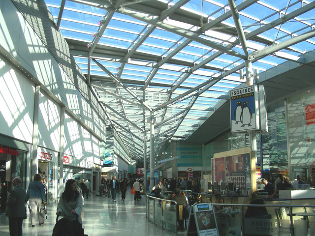
The
Liberty - Romford Until recently The Liberty was open to the elements - but a multi-million pound redevelopment has resulted in this glass roof, which makes it look a bit like an airport.
83:
51:
687:
671:
589:
545:
679:
454:
854:
790:
786:
683:
667:
541:
450:
446:
438:
695:
691:
675:
629:
585:
434:
442:
943:
592:"}},"text\/plain":{"en":{"P275":"Creative Commons Attribution-ShareAlike 2.0 Generic"}}}}": -->
698:"}},"text\/plain":{"en":{"P973":"https:\/\/www.geograph.org.uk\/photo\/272005"}}}}": -->
721:
615:
571:
238:
741:
276:
1010:
This file contains additional information, probably added from the digital camera or scanner used to create or digitize it.
366:
526:
864:
831:
804:
749:
705:
555:
519:
506:
491:
932:
927:
764:
734:
639:
599:
464:
423:
42:
322:
1013:
If the file has been modified from its original state, some details may not fully reflect the modified file.
365:– If you remix, transform, or build upon the material, you must distribute your contributions under the
283:
on the
Geograph website for the photographer's contact details. The copyright on this image is owned by
457:"}},"text\/plain":{"en":{"P3831":"photographer"}}}}": -->
548:"}},"text\/plain":{"en":{"P6216":"copyrighted"}}}}": -->
797:"}},"text\/plain":{"en":{"P7787":"90 degree"}}}}": -->
91:
183:
771:
756:
319:
167:
498:
8:
263:
244:
288:
78:
413:
146:
874:
814:
715:
649:
609:
565:
474:
156:
969:
268:
280:
900:
Click on a date/time to view the file as it appeared at that time.
964:
230:
215:
51° 34′ 42″ N, 0° 11′ 02″ E
135:
66:
407:
Add a one-line explanation of what this file represents
997:
958:
987:
978:
898:
116:
The
Liberty - Romford - geograph.org.uk - 272005.jpg
90:
Commons is a freely licensed media file repository.
52:
The_Liberty_-_Romford_-_geograph.org.uk_-_272005.jpg
616:
Creative
Commons Attribution-ShareAlike 2.0 Generic
590:
Creative
Commons Attribution-ShareAlike 2.0 Generic
56:(640 × 480 pixels, file size: 129 KB, MIME type:
376:https://creativecommons.org/licenses/by-sa/2.0
71:
382:Creative Commons Attribution-Share Alike 2.0
300:
131:
113:
696:https:\/\/www.geograph.org.uk\/photo\/272005
152:
141:
14:
794:
443:https:\/\/www.geograph.org.uk\/profile\/759
342:– to copy, distribute and transmit the work
980:The following other wikis use this file:
772:https://www.geograph.org.uk/photo/272005
499:https://www.geograph.org.uk/profile/759
237:View this and other nearby images on:
960:The following 2 pages use this file:
190:
102:
287:and is licensed for reuse under the
205:
891:
323:Attribution-Share Alike 2.0 Generic
311:
306:
291:Attribution-ShareAlike 2.0 license.
13:
1008:
412:
406:
297:
274:
120:
103:
49:
1034:
1015:
411:
397:
353:Under the following conditions:
318:This file is licensed under the
310:
305:
299:
267:
243:
229:
221:
70:
31:
21:
394:
121:
46:No higher resolution available.
975:
895:
722:file available on the internet
672:file available on the internet
393:
275:This image was taken from the
26:
1:
805:coordinates of depicted place
787:coordinates of depicted place
36:
955:
742:Geograph Britain and Ireland
680:Geograph Britain and Ireland
520:object of statement has role
451:object of statement has role
419:Items portrayed in this file
259:
7:
1005:
220:
10:
1039:
994:Usage on www.wikidata.org
984:Usage on nl.wikipedia.org
367:same or compatible license
196:John Winfield /
177:John Winfield /
110:
105:
892:
16:
820:51°34'41.5"N, 0°11'2.4"E
750:geograph.org.uk image ID
684:geograph.org.uk image ID
396:
333:
77:This is a file from the
41:
949:
928:20:30, 12 December 2010
168:required by the license
134:
81:. Information from its
281:this photograph's page
249:51.578200; 0.184000
84:description page there
198:The Liberty - Romford
179:The Liberty - Romford
348:– to adapt the work
507:author name string
447:author name string
1026:
1025:
976:Global file usage
953:
796:
600:copyright license
586:copyright license
405:
296:
295:
279:collection. See
254:
253:
203:
202:
171:
99:
98:
79:Wikimedia Commons
32:Global file usage
1030:
1016:
940:
902:
842:
841:
836:
774:
769:
765:described at URL
759:
754:
744:
739:
692:described at URL
556:copyright status
542:copyright status
529:
524:
514:
511:
501:
496:
403:
389:
386:
383:
380:
377:
369:as the original.
331:
320:Creative Commons
314:
313:
309:
308:
303:
302:
289:Creative Commons
277:Geograph project
271:
264:
250:
247:
233:
232:
226:
225:
224:
218:
217:
206:
165:
137:
125:
117:
111:
95:
74:
73:
67:
61:
59:
1038:
1037:
1033:
1032:
1031:
1029:
1028:
1027:
1004:
974:
954:
946:
938:
894:
893:
890:
889:
888:
887:
886:
885:
884:
883:
881:
871:
870:
869:
867:
852:
851:
850:
849:
848:
847:
846:
845:
844:
843:
839:
837:
834:
825:
824:
823:
821:
811:
810:
809:
807:
784:
783:
782:
781:
780:
779:
778:
777:
776:
775:
770:
767:
761:
760:
755:
752:
746:
745:
740:
737:
728:
727:
726:
724:
712:
711:
710:
708:
665:
664:
663:
662:
661:
660:
659:
658:
656:
655:3 November 2006
646:
645:
644:
642:
627:
626:
625:
624:
623:
622:
621:
620:
618:
606:
605:
604:
602:
583:
582:
581:
580:
579:
578:
577:
576:
574:
562:
561:
560:
558:
539:
538:
537:
536:
535:
534:
533:
532:
531:
530:
525:
522:
516:
515:
512:
509:
503:
502:
497:
494:
485:
484:
483:
481:
471:
470:
469:
467:
432:
431:
430:
429:
428:
426:
410:
409:
408:
391:
390:
387:
384:
381:
378:
375:
374:
332:
329:
326:
315:
292:
262:
248:
222:
213:
212:
209:Object location
204:
193:
186:
174:
147:geograph.org.uk
136:3 November 2006
127:
115:
108:
101:
100:
89:
88:
87:is shown below.
63:
57:
55:
48:
47:
12:
11:
5:
1036:
1024:
1023:
1020:
1007:
1003:
1002:
1001:
1000:
992:
991:
990:
977:
973:
972:
967:
957:
952:
951:
948:
944:
941:
935:
930:
925:
921:
920:
917:
914:
911:
908:
905:
897:
882:
879:
877:
876:
875:
873:
872:
868:
863:
861:
860:
859:
858:
856:
830:
829:
828:
827:
826:
822:
819:
817:
816:
815:
813:
812:
808:
803:
801:
800:
799:
798:
792:
788:
763:
762:
748:
747:
733:
732:
731:
730:
729:
725:
720:
718:
717:
716:
714:
713:
709:
706:source of file
704:
702:
701:
700:
699:
697:
693:
689:
685:
681:
677:
673:
669:
668:source of file
657:
654:
652:
651:
650:
648:
647:
643:
638:
636:
635:
634:
633:
631:
619:
614:
612:
611:
610:
608:
607:
603:
598:
596:
595:
594:
593:
591:
587:
575:
570:
568:
567:
566:
564:
563:
559:
554:
552:
551:
550:
549:
547:
543:
518:
517:
505:
504:
490:
489:
488:
487:
486:
482:
479:
477:
476:
475:
473:
472:
468:
463:
461:
460:
459:
458:
456:
452:
448:
444:
440:
436:
427:
422:
420:
417:
416:
415:
414:
402:
401:
398:
395:
373:
372:
371:
370:
360:
351:
350:
349:
343:
336:You are free:
327:
317:
316:
298:
294:
293:
272:
261:
258:
252:
251:
241:
235:
210:
201:
200:
194:
191:
188:
187:
182:
175:
172:
160:
159:
154:
150:
149:
143:
139:
138:
133:
129:
128:
118:
109:
107:
104:
97:
96:
75:
65:
64:
45:
40:
39:
34:
29:
24:
19:
9:
6:
4:
3:
2:
1035:
1021:
1018:
1017:
1014:
1011:
999:
996:
995:
993:
989:
986:
985:
983:
982:
981:
971:
968:
966:
963:
962:
961:
947:
942:
936:
934:
931:
929:
926:
923:
922:
918:
915:
912:
909:
906:
904:
903:
901:
878:
866:
862:
833:
818:
806:
802:
773:
766:
758:
751:
743:
736:
723:
719:
707:
703:
653:
641:
637:
617:
613:
601:
597:
573:
569:
557:
553:
528:
521:
513:John Winfield
508:
500:
493:
478:
466:
462:
425:
421:
418:
399:
392:
379:CC BY-SA 2.0
368:
364:
361:
358:
355:
354:
352:
347:
344:
341:
338:
337:
335:
334:
330:John Winfield
328:Attribution:
324:
321:
304:
290:
286:
285:John Winfield
282:
278:
273:
270:
266:
265:
257:
256:
246:
242:
240:
239:OpenStreetMap
236:
234:
216:
211:
208:
207:
199:
195:
189:
185:
181: /
180:
176:
169:
164:
162:
161:
158:
157:John Winfield
155:
151:
148:
144:
140:
130:
124:
119:
112:
93:
86:
85:
80:
76:
69:
68:
62:
53:
44:
38:
35:
33:
30:
28:
25:
23:
20:
18:
15:
1012:
1009:
979:
959:
899:
896:File history
527:photographer
455:photographer
362:
356:
345:
339:
284:
255:
219:
197:
184:CC BY-SA 2.0
178:
122:
92:You can help
82:
50:
22:File history
970:The Liberty
945:GeographBot
572:copyrighted
546:copyrighted
363:share alike
357:attribution
163:Attribution
114:Description
1019:_error
956:File usage
937:640 × 480
913:Dimensions
880:image/jpeg
865:media type
855:media type
480:some value
58:image/jpeg
27:File usage
998:Q16894126
910:Thumbnail
907:Date/Time
640:inception
630:inception
260:Licensing
192:InfoField
173:InfoField
123:English:
1006:Metadata
939:(129 KB)
735:operator
676:operator
400:Captions
346:to remix
340:to share
325:license.
37:Metadata
988:Romford
965:Romford
924:current
919:Comment
832:heading
791:heading
465:creator
435:creator
424:depicts
404:English
106:Summary
54:
840:degree
795:degree
757:272005
688:272005
227:
153:Author
142:Source
145:From
916:User
388:true
385:true
132:Date
17:File
838:90
492:URL
439:URL
835::
768::
753::
738::
523::
510::
495::
1022:0
170:)
166:(
94:.
60:)
_heading:90.00&language=en)
