682:"}},"text\/plain":{"en":{"":"coordinates of the point of view"}}},"{\"value\":{\"latitude\":57.46523,\"longitude\":-4.23338,\"altitude\":null,\"precision\":1.0e-5,\"globe\":\"http:\\\/\\\/www.wikidata.org\\\/entity\\\/Q2\"},\"type\":\"globecoordinate\"}":{"text\/html":{"en":{"P1259":"57\u00b027'54.83"N, 4\u00b014'0.17"W"}},"text\/plain":{"en":{"P1259":"57\u00b027'54.83\"N, 4\u00b014'0.17\"W"}}}}": -->
644:"}},"text\/plain":{"en":{"":"inception"}}},"{\"value\":{\"time\":\"+2022-06-04T00:00:00Z\",\"timezone\":0,\"before\":0,\"after\":0,\"precision\":11,\"calendarmodel\":\"http:\\\/\\\/www.wikidata.org\\\/entity\\\/Q1985727\"},\"type\":\"time\"}":{"text\/html":{"en":{"P571":"4 June 2022"}},"text\/plain":{"en":{"P571":"4 June 2022"}}}}": -->
43:
401:
208:
222:
253:
258:
99:
413:"}},"text\/plain":{"en":{"P2093":"Pampuco","P4174":"Pampuco"}}},"{\"value\":{\"entity-type\":\"property\",\"numeric-id\":4174,\"id\":\"P4174\"},\"type\":\"wikibase-entityid\"}":{"text\/html":{"en":{"":"
556:"}},"text\/plain":{"en":{"":"copyright license"}}},"{\"value\":{\"entity-type\":\"item\",\"numeric-id\":18199165,\"id\":\"Q18199165\"},\"type\":\"wikibase-entityid\"}":{"text\/html":{"en":{"P275":"
512:"}},"text\/plain":{"en":{"":"copyright status"}}},"{\"value\":{\"entity-type\":\"item\",\"numeric-id\":50423863,\"id\":\"Q50423863\"},\"type\":\"wikibase-entityid\"}":{"text\/html":{"en":{"P6216":"
600:"}},"text\/plain":{"en":{"":"source of file"}}},"{\"value\":{\"entity-type\":\"item\",\"numeric-id\":66458942,\"id\":\"Q66458942\"},\"type\":\"wikibase-entityid\"}":{"text\/html":{"en":{"P7482":"
417:"}},"text\/plain":{"en":{"":"Wikimedia username"}}},"{\"value\":{\"entity-type\":\"property\",\"numeric-id\":2699,\"id\":\"P2699\"},\"type\":\"wikibase-entityid\"}":{"text\/html":{"en":{"":"
358:"}},"text\/plain":{"en":{"":"depicts"}}},"{\"value\":{\"entity-type\":\"item\",\"numeric-id\":108881141,\"id\":\"Q108881141\"},\"type\":\"wikibase-entityid\"}":{"text\/html":{"en":{"P180":"
405:"}},"text\/plain":{"en":{"":"creator"}}},"{\"value\":{\"entity-type\":\"property\",\"numeric-id\":2093,\"id\":\"P2093\"},\"type\":\"wikibase-entityid\"}":{"text\/html":{"en":{"":"
678:
409:"}},"text\/plain":{"en":{"":"author name string"}}},"{\"value\":\"Pampuco\",\"type\":\"string\"}":{"text\/html":{"en":{"P2093":"Pampuco","P4174":"
421:"}},"text\/plain":{"en":{"":"URL"}}},"{\"value\":\"https:\\\/\\\/commons.wikimedia.org\\\/wiki\\\/User:Pampuco\",\"type\":\"string\"}":{"text\/html":{"en":{"P2699":"
299:– You must give appropriate credit, provide a link to the license, and indicate if changes were made. You may do so in any reasonable manner, but not in any way that suggests the licensor endorses you or your use.
205:
410:
199:
359:
601:
557:
513:
422:
679:
597:
509:
418:
414:
406:
641:
553:
402:
355:
560:"}},"text\/plain":{"en":{"P275":"Creative Commons Attribution-ShareAlike 4.0 International"}}}}": -->
425:"}},"text\/plain":{"en":{"P2699":"https:\/\/commons.wikimedia.org\/wiki\/User:Pampuco"}}}}": -->
65:
61:
57:
53:
47:
110:
78:
388:
627:
583:
539:
215:
835:
This file contains additional information, probably added from the digital camera or scanner used to create or digitize it.
306:
689:
611:
523:
487:
472:
459:
604:"}},"text\/plain":{"en":{"P7482":"original creation by uploader"}}}}": -->
651:
567:
432:
372:
794:
479:
268:
362:"}},"text\/plain":{"en":{"P180":"Tomnahurich Cemetery"}}}}": -->
838:
If the file has been modified from its original state, some details may not fully reflect the modified file.
305:– If you remix, transform, or build upon the material, you must distribute your contributions under the
516:"}},"text\/plain":{"en":{"P6216":"copyrighted"}}}}": -->
118:
757:
752:
69:
42:
494:
789:
265:
8:
221:
105:
240:
I, the copyright holder of this work, hereby publish it under the following license:
182:
768:
699:
661:
621:
577:
533:
442:
382:
725:
Click on a date/time to view the file as it appeared at that time.
207:
200:
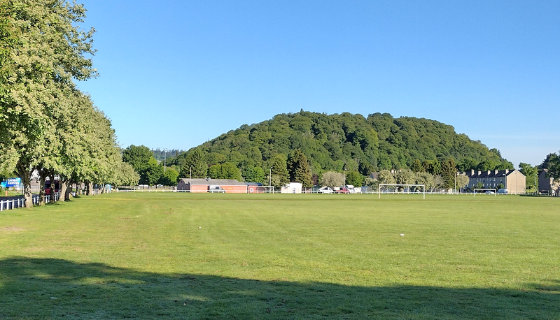
57° 27′ 54.83″ N, 4° 14′ 00.17″ W
584:
Creative
Commons Attribution-ShareAlike 4.0 International
558:
Creative
Commons Attribution-ShareAlike 4.0 International
162:
93:
812:
822:
83:(2,319 × 1,329 pixels, file size: 4.87 MB, MIME type:
783:
803:
723:
117:
Commons is a freely licensed media file repository.
423:
https:\/\/commons.wikimedia.org\/wiki\/User:Pampuco
348:Tomnahurich hill (Inverness, Scotland): SW view
153:Tomnahurich hill (Inverness, Scotland): SW view
316:https://creativecommons.org/licenses/by-sa/4.0
98:
322:Creative Commons Attribution-Share Alike 4.0
246:
158:
140:
178:
168:
14:
282:– to copy, distribute and transmit the work
495:https://commons.wikimedia.org/User:Pampuco
805:The following other wikis use this file:
269:Attribution-Share Alike 4.0 International
214:View this and other nearby images on:
785:The following 2 pages use this file:
129:
190:
775:Uploaded own work with UploadWizard
716:
257:
252:
13:
833:
353:
347:
243:
239:
147:
130:
76:
867:
840:
352:
690:coordinates of the point of view
680:coordinates of the point of view
338:
293:Under the following conditions:
264:This file is licensed under the
256:
251:
245:
220:
206:
97:
31:
21:
795:User:Stinglehammer/Scottish WLM
335:
148:
800:
720:
334:
26:
1:
628:original creation by uploader
602:original creation by uploader
36:
780:
368:Items portrayed in this file
233:
143:Tomnahurich hill SW view.png
7:
830:
10:
872:
819:Usage on www.wikidata.org
809:Usage on it.wikipedia.org
705:57°27'54.83"N, 4°14'0.17"W
307:same or compatible license
137:
132:
717:
172:
16:
337:
273:
104:This is a file from the
41:
774:
161:
108:. Information from its
226:57.465230; -4.233380
111:description page there
46:Size of this preview:
844:Horizontal resolution
790:Tomnahurich Cemetery
389:Tomnahurich Cemetery
360:Tomnahurich Cemetery
70:2,319 × 1,329 pixels
852:Vertical resolution
753:13:46, 17 June 2022
288:– to adapt the work
52:Other resolutions:
473:Wikimedia username
460:author name string
415:Wikimedia username
407:author name string
66:1,280 × 734 pixels
62:1,024 × 587 pixels
859:
858:
801:Global file usage
778:
568:copyright license
554:copyright license
346:
231:
230:
188:
187:
126:
125:
106:Wikimedia Commons
32:Global file usage
863:
841:
765:
727:
524:copyright status
510:copyright status
497:
492:
482:
477:
467:
464:
344:
329:
326:
323:
320:
317:
309:as the original.
266:Creative Commons
260:
259:
255:
254:
249:
248:
227:
224:
210:
209:
203:
202:
191:
174:
164:
152:
144:
138:
122:
101:
100:
94:
88:
86:
73:
58:640 × 367 pixels
54:320 × 183 pixels
48:800 × 458 pixels
871:
870:
866:
865:
864:
862:
861:
860:
829:
799:
779:
771:
763:
719:
718:
715:
714:
713:
712:
711:
710:
709:
708:
706:
696:
695:
694:
692:
677:
676:
675:
674:
673:
672:
671:
670:
668:
658:
657:
656:
654:
639:
638:
637:
636:
635:
634:
633:
632:
630:
618:
617:
616:
614:
595:
594:
593:
592:
591:
590:
589:
588:
586:
574:
573:
572:
570:
551:
550:
549:
548:
547:
546:
545:
544:
542:
530:
529:
528:
526:
507:
506:
505:
504:
503:
502:
501:
500:
499:
498:
493:
490:
484:
483:
478:
475:
469:
468:
465:
462:
453:
452:
451:
449:
439:
438:
437:
435:
400:
399:
398:
397:
396:
395:
394:
393:
391:
379:
378:
377:
375:
351:
350:
349:
332:
331:
330:
327:
324:
321:
318:
315:
314:
272:
261:
242:
241:
236:
225:
198:
197:
194:Camera location
189:
154:
142:
135:
128:
127:
116:
115:
114:is shown below.
90:
84:
82:
75:
74:
51:
12:
11:
5:
869:
857:
856:
853:
849:
848:
845:
832:
828:
827:
826:
825:
817:
816:
815:
802:
798:
797:
792:
782:
777:
776:
773:
769:
766:
762:2,319 × 1,329
760:
755:
750:
746:
745:
742:
739:
736:
733:
730:
722:
707:
704:
702:
701:
700:
698:
697:
693:
688:
686:
685:
684:
683:
681:
669:
666:
664:
663:
662:
660:
659:
655:
650:
648:
647:
646:
645:
643:
631:
626:
624:
623:
622:
620:
619:
615:
612:source of file
610:
608:
607:
606:
605:
603:
599:
598:source of file
587:
582:
580:
579:
578:
576:
575:
571:
566:
564:
563:
562:
561:
559:
555:
543:
538:
536:
535:
534:
532:
531:
527:
522:
520:
519:
518:
517:
515:
511:
486:
485:
471:
470:
458:
457:
456:
455:
454:
450:
447:
445:
444:
443:
441:
440:
436:
431:
429:
428:
427:
426:
424:
420:
416:
412:
408:
404:
392:
387:
385:
384:
383:
381:
380:
376:
371:
369:
366:
365:
364:
363:
361:
357:
343:
342:
339:
336:
313:
312:
311:
310:
300:
291:
290:
289:
283:
276:You are free:
263:
262:
244:
238:
237:
235:
232:
229:
228:
218:
212:
195:
186:
185:
180:
176:
175:
170:
166:
165:
160:
156:
155:
145:
136:
134:
131:
124:
123:
102:
92:
91:
45:
40:
39:
34:
29:
24:
19:
9:
6:
4:
3:
2:
868:
854:
851:
850:
846:
843:
842:
839:
836:
824:
821:
820:
818:
814:
811:
810:
808:
807:
806:
796:
793:
791:
788:
787:
786:
772:
767:
761:
759:
756:
754:
751:
748:
747:
743:
740:
737:
734:
731:
729:
728:
726:
703:
691:
687:
665:
653:
649:
629:
625:
613:
609:
585:
581:
569:
565:
541:
537:
525:
521:
496:
489:
481:
474:
461:
446:
434:
430:
390:
386:
374:
370:
367:
340:
333:
319:CC BY-SA 4.0
308:
304:
301:
298:
295:
294:
292:
287:
284:
281:
278:
277:
275:
274:
270:
267:
250:
223:
219:
217:
216:OpenStreetMap
213:
211:
201:
196:
193:
192:
184:
181:
177:
171:
167:
157:
151:
146:
139:
120:
113:
112:
107:
103:
96:
95:
89:
80:
79:Original file
71:
67:
63:
59:
55:
49:
44:
38:
35:
33:
30:
28:
25:
23:
20:
18:
15:
837:
834:
804:
784:
724:
721:File history
302:
296:
285:
279:
149:
119:You can help
109:
77:
22:File history
813:Tomnahurich
667:4 June 2022
540:copyrighted
514:copyrighted
303:share alike
297:attribution
163:4 June 2022
141:Description
823:Q108881141
781:File usage
738:Dimensions
448:some value
27:File usage
855:28.35 dpc
847:28.35 dpc
764:(4.87 MB)
735:Thumbnail
732:Date/Time
652:inception
642:inception
234:Licensing
150:English:
85:image/png
831:Metadata
341:Captions
286:to remix
280:to share
271:license.
173:Own work
37:Metadata
770:Pampuco
749:current
744:Comment
480:Pampuco
466:Pampuco
433:creator
411:Pampuco
403:creator
373:depicts
356:depicts
345:English
183:Pampuco
133:Summary
81:
204:
179:Author
169:Source
741:User
328:true
325:true
159:Date
17:File
488:URL
419:URL
491::
476::
463::
68:|
64:|
60:|
56:|
50:.
121:.
87:)
72:.
