334:
672:"}},"text\/plain":{"en":{"":"inception"}}},"{\"value\":{\"time\":\"+2013-09-02T00:00:00Z\",\"timezone\":0,\"before\":0,\"after\":0,\"precision\":11,\"calendarmodel\":\"http:\\\/\\\/www.wikidata.org\\\/entity\\\/Q1985727\"},\"type\":\"time\"}":{"text\/html":{"en":{"P571":"2 September 2013"}},"text\/plain":{"en":{"P571":"2 September 2013"}}}}": -->
473:
181:
195:
233:
238:
72:
485:"}},"text\/plain":{"en":{"P2093":"Salix alba","P4174":"Salix alba"}}},"{\"value\":{\"entity-type\":\"property\",\"numeric-id\":4174,\"id\":\"P4174\"},\"type\":\"wikibase-entityid\"}":{"text\/html":{"en":{"":"
354:"}},"text\/plain":{"en":{"P1552":"topographic prominence"}}},"{\"value\":{\"entity-type\":\"item\",\"numeric-id\":33141096,\"id\":\"Q33141096\"},\"type\":\"wikibase-entityid\"}":{"text\/html":{"en":{"P180":"
342:"}},"text\/plain":{"en":{"P180":"Great Pond Mountain"}}},"{\"value\":{\"entity-type\":\"item\",\"numeric-id\":33136277,\"id\":\"Q33136277\"},\"type\":\"wikibase-entityid\"}":{"text\/html":{"en":{"P180":"
628:"}},"text\/plain":{"en":{"":"copyright license"}}},"{\"value\":{\"entity-type\":\"item\",\"numeric-id\":14946043,\"id\":\"Q14946043\"},\"type\":\"wikibase-entityid\"}":{"text\/html":{"en":{"P275":"
584:"}},"text\/plain":{"en":{"":"copyright status"}}},"{\"value\":{\"entity-type\":\"item\",\"numeric-id\":50423863,\"id\":\"Q50423863\"},\"type\":\"wikibase-entityid\"}":{"text\/html":{"en":{"P6216":"
748:"}},"text\/plain":{"en":{"":"source of file"}}},"{\"value\":{\"entity-type\":\"item\",\"numeric-id\":66458942,\"id\":\"Q66458942\"},\"type\":\"wikibase-entityid\"}":{"text\/html":{"en":{"P7482":"
350:"}},"text\/plain":{"en":{"":"has characteristic"}}},"{\"value\":{\"entity-type\":\"item\",\"numeric-id\":656751,\"id\":\"Q656751\"},\"type\":\"wikibase-entityid\"}":{"text\/html":{"en":{"P1552":"
489:"}},"text\/plain":{"en":{"":"Wikimedia username"}}},"{\"value\":{\"entity-type\":\"property\",\"numeric-id\":2699,\"id\":\"P2699\"},\"type\":\"wikibase-entityid\"}":{"text\/html":{"en":{"":"
346:"}},"text\/plain":{"en":{"P180":"Atkins Hill"}}},"{\"value\":{\"entity-type\":\"property\",\"numeric-id\":1552,\"id\":\"P1552\"},\"type\":\"wikibase-entityid\"}":{"text\/html":{"en":{"":"
338:"}},"text\/plain":{"en":{"":"depicts"}}},"{\"value\":{\"entity-type\":\"item\",\"numeric-id\":14951232,\"id\":\"Q14951232\"},\"type\":\"wikibase-entityid\"}":{"text\/html":{"en":{"P180":"
477:"}},"text\/plain":{"en":{"":"creator"}}},"{\"value\":{\"entity-type\":\"property\",\"numeric-id\":2093,\"id\":\"P2093\"},\"type\":\"wikibase-entityid\"}":{"text\/html":{"en":{"":"
744:
493:"}},"text\/plain":{"en":{"":"URL"}}},"{\"value\":\"http:\\\/\\\/commons.wikimedia.org\\\/wiki\\\/User:Salix_alba\",\"type\":\"string\"}":{"text\/html":{"en":{"P2699":"
879:
43:
279:– You must give appropriate credit, provide a link to the license, and indicate if changes were made. You may do so in any reasonable manner, but not in any way that suggests the licensor endorses you or your use.
482:
178:
172:
749:
629:
585:
355:
343:
339:
494:
351:
745:
707:
581:
490:
486:
478:
347:
669:
625:
474:
335:
497:"}},"text\/plain":{"en":{"P2699":"http:\/\/commons.wikimedia.org\/wiki\/User:Salix_alba"}}}}": -->
632:"}},"text\/plain":{"en":{"P275":"Creative Commons Attribution-ShareAlike 3.0 Unported"}}}}": -->
919:
83:
775:
655:
611:
439:
401:
384:
188:
51:
987:
This file contains additional information, probably added from the digital camera or scanner used to create or digitize it.
459:
421:
286:
759:
717:
595:
559:
544:
531:
452:
414:
752:"}},"text\/plain":{"en":{"P7482":"original creation by uploader"}}}}": -->
679:
639:
504:
368:
551:
248:
990:
If the file has been modified from its original state, some details may not fully reflect the modified file.
285:– If you remix, transform, or build upon the material, you must distribute your contributions under the
358:"}},"text\/plain":{"en":{"P180":"Mead Mountain"}}}}": -->
588:"}},"text\/plain":{"en":{"P6216":"copyrighted"}}}}": -->
91:
861:
566:
829:
824:
42:
245:
207:
8:
194:
126:
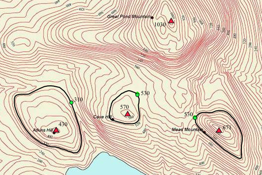
Map showing the topographic prominence of three peaks near Great Pond
Mountain, Maine
78:
220:
I, the copyright holder of this work, hereby publish it under the following license:
1018:
939:
155:
840:
909:
769:
727:
689:
649:
605:
514:
433:
395:
378:
929:
797:
Click on a date/time to view the file as it appeared at that time.
949:
135:
180:
894:
959:
328:
Map showing the topographic prominence of 3 peaks in Maine
173:
44° 35′ 42″ N, 68° 39′ 54″ W
66:
904:
974:
889:
969:
855:
495:
http:\/\/commons.wikimedia.org\/wiki\/User:Salix_alba
870:
795:
656:
Creative
Commons Attribution-ShareAlike 3.0 Unported
630:
Creative
Commons Attribution-ShareAlike 3.0 Unported
90:
Commons is a freely licensed media file repository.
56:(533 × 357 pixels, file size: 525 KB, MIME type:
296:https://creativecommons.org/licenses/by-sa/3.0
71:
302:Creative Commons Attribution-Share Alike 3.0
226:
131:
113:
567:http://commons.wikimedia.org/User:Salix_alba
151:
141:
14:
262:– to copy, distribute and transmit the work
872:The following other wikis use this file:
187:View this and other nearby images on:
102:
249:Attribution-Share Alike 3.0 Unported
163:
857:The following page uses this file:
847:User created page with UploadWizard
788:
237:
232:
13:
985:
333:
327:
223:
219:
120:
103:
49:
1035:
992:
910:Usuario:PepTheVoyager/Prominencia
332:
718:coordinates of the point of view
708:coordinates of the point of view
318:
273:Under the following conditions:
244:This file is licensed under the
236:
231:
225:
193:
179:
70:
31:
21:
315:
121:
46:No higher resolution available.
867:
792:
314:
26:
1:
776:original creation by uploader
750:original creation by uploader
36:
852:
364:Items portrayed in this file
213:
7:
982:
10:
1040:
966:Usage on www.wikidata.org
956:Usage on sv.wikipedia.org
946:Usage on sl.wikipedia.org
936:Usage on sk.wikipedia.org
926:Usage on ro.wikipedia.org
916:Usage on ja.wikipedia.org
901:Usage on es.wikipedia.org
886:Usage on cs.wikipedia.org
876:Usage on bh.wikipedia.org
287:same or compatible license
136:2 September 2013, 04:18:07
116:Topographic prominence.png
110:
105:
52:Topographic_prominence.png
789:
145:
16:
317:
253:
77:This is a file from the
41:
940:Relatívna výška vrcholu
846:
825:03:27, 2 September 2013
134:
81:. Information from its
880:टोपोग्राफिक प्रॉमिनेंस
862:Topographic prominence
733:44°35'42"N, 68°39'54"W
460:topographic prominence
422:topographic prominence
352:topographic prominence
199:44.595000; -68.665000
84:description page there
996:Horizontal resolution
1004:Vertical resolution
385:Great Pond Mountain
340:Great Pond Mountain
268:– to adapt the work
208:File:Cntr-map-1.jpg
545:Wikimedia username
532:author name string
487:Wikimedia username
479:author name string
453:has characteristic
415:has characteristic
348:has characteristic
1027:
1026:
930:Cotă (topografie)
868:Global file usage
850:
640:copyright license
626:copyright license
326:
204:
203:
161:
160:
99:
98:
79:Wikimedia Commons
32:Global file usage
1031:
1021:
1019:www.inkscape.org
993:
950:Relativna višina
837:
799:
695:2 September 2013
596:copyright status
582:copyright status
569:
564:
554:
549:
539:
536:
462:
457:
424:
419:
324:
309:
306:
303:
300:
297:
289:as the original.
246:Creative Commons
240:
239:
235:
234:
229:
228:
200:
197:
183:
182:
176:
175:
164:
147:
137:
125:
117:
111:
95:
74:
73:
67:
61:
59:
1039:
1038:
1034:
1033:
1032:
1030:
1029:
1028:
1017:
981:
866:
851:
843:
835:
791:
790:
787:
786:
785:
784:
783:
782:
781:
780:
778:
766:
765:
764:
762:
743:
742:
741:
740:
739:
738:
737:
736:
734:
724:
723:
722:
720:
705:
704:
703:
702:
701:
700:
699:
698:
696:
686:
685:
684:
682:
667:
666:
665:
664:
663:
662:
661:
660:
658:
646:
645:
644:
642:
623:
622:
621:
620:
619:
618:
617:
616:
614:
602:
601:
600:
598:
579:
578:
577:
576:
575:
574:
573:
572:
571:
570:
565:
562:
556:
555:
550:
547:
541:
540:
537:
534:
525:
524:
523:
521:
511:
510:
509:
507:
472:
471:
470:
469:
468:
467:
466:
465:
464:
463:
458:
455:
446:
445:
444:
442:
431:
430:
429:
428:
427:
426:
425:
420:
417:
408:
407:
406:
404:
393:
392:
391:
390:
389:
387:
375:
374:
373:
371:
331:
330:
329:
312:
311:
310:
307:
304:
301:
298:
295:
294:
252:
241:
222:
221:
216:
198:
171:
170:
167:Camera location
162:
127:
115:
108:
101:
100:
89:
88:
87:is shown below.
63:
57:
55:
48:
47:
12:
11:
5:
1037:
1025:
1024:
1023:
1022:
1013:
1009:
1008:
1005:
1001:
1000:
997:
984:
980:
979:
978:
977:
972:
964:
963:
962:
954:
953:
952:
944:
943:
942:
934:
933:
932:
924:
923:
922:
914:
913:
912:
907:
899:
898:
897:
892:
884:
883:
882:
869:
865:
864:
854:
849:
848:
845:
841:
838:
832:
827:
822:
818:
817:
814:
811:
808:
805:
802:
794:
779:
774:
772:
771:
770:
768:
767:
763:
760:source of file
758:
756:
755:
754:
753:
751:
747:
746:source of file
735:
732:
730:
729:
728:
726:
725:
721:
716:
714:
713:
712:
711:
709:
697:
694:
692:
691:
690:
688:
687:
683:
678:
676:
675:
674:
673:
671:
659:
654:
652:
651:
650:
648:
647:
643:
638:
636:
635:
634:
633:
631:
627:
615:
610:
608:
607:
606:
604:
603:
599:
594:
592:
591:
590:
589:
587:
583:
558:
557:
543:
542:
530:
529:
528:
527:
526:
522:
519:
517:
516:
515:
513:
512:
508:
503:
501:
500:
499:
498:
496:
492:
488:
484:
480:
476:
451:
450:
449:
448:
447:
443:
438:
436:
435:
434:
432:
413:
412:
411:
410:
409:
405:
400:
398:
397:
396:
394:
388:
383:
381:
380:
379:
377:
376:
372:
367:
365:
362:
361:
360:
359:
357:
353:
349:
345:
341:
337:
323:
322:
319:
316:
293:
292:
291:
290:
280:
271:
270:
269:
263:
256:You are free:
243:
242:
224:
218:
217:
215:
212:
202:
201:
191:
185:
168:
159:
158:
153:
149:
148:
143:
139:
138:
133:
129:
128:
118:
109:
107:
104:
97:
96:
75:
65:
64:
45:
40:
39:
34:
29:
24:
19:
9:
6:
4:
3:
2:
1036:
1020:
1016:
1015:
1014:
1012:Software used
1011:
1010:
1006:
1003:
1002:
998:
995:
994:
991:
988:
976:
973:
971:
968:
967:
965:
961:
958:
957:
955:
951:
948:
947:
945:
941:
938:
937:
935:
931:
928:
927:
925:
921:
918:
917:
915:
911:
908:
906:
903:
902:
900:
896:
893:
891:
888:
887:
885:
881:
878:
877:
875:
874:
873:
863:
860:
859:
858:
844:
839:
833:
831:
828:
826:
823:
820:
819:
815:
812:
809:
806:
803:
801:
800:
798:
777:
773:
761:
757:
731:
719:
715:
693:
681:
677:
657:
653:
641:
637:
613:
609:
597:
593:
568:
561:
553:
546:
533:
518:
506:
502:
461:
454:
441:
440:Mead Mountain
437:
423:
416:
403:
399:
386:
382:
370:
366:
363:
356:Mead Mountain
320:
313:
299:CC BY-SA 3.0
288:
284:
281:
278:
275:
274:
272:
267:
264:
261:
258:
257:
255:
254:
250:
247:
230:
211:
209:
206:Derived from
196:
192:
190:
189:OpenStreetMap
186:
184:
174:
169:
166:
165:
157:
154:
150:
144:
140:
130:
124:
119:
112:
93:
86:
85:
80:
76:
69:
68:
62:
53:
44:
38:
35:
33:
30:
28:
25:
23:
20:
18:
15:
989:
986:
960:Primärfaktor
920:プロミネンス (地誌学)
871:
856:
796:
793:File history
282:
276:
265:
259:
205:
122:
92:You can help
82:
50:
22:File history
905:Prominencia
612:copyrighted
586:copyrighted
402:Atkins Hill
344:Atkins Hill
283:share alike
277:attribution
114:Description
975:Q109828918
890:Prominence
853:File usage
842:Salix alba
834:533 × 357
810:Dimensions
552:Salix alba
538:Salix alba
520:some value
483:Salix alba
156:Salix alba
27:File usage
1007:35.43 dpc
999:35.43 dpc
970:Q10261228
807:Thumbnail
804:Date/Time
680:inception
670:inception
214:Licensing
123:English:
58:image/png
983:Metadata
895:Výškopis
836:(525 KB)
321:Captions
266:to remix
260:to share
251:license.
146:Own work
37:Metadata
821:current
816:Comment
505:creator
475:creator
369:depicts
336:depicts
325:English
106:Summary
54:
177:
152:Author
142:Source
813:User
308:true
305:true
132:Date
17:File
560:URL
491:URL
563::
548::
535::
456::
418::
210:.
94:.
60:)