795:"}},"text\/plain":{"en":{"":"coordinates of the point of view"}}},"{\"value\":{\"latitude\":51.15752,\"longitude\":-1.8096,\"altitude\":null,\"precision\":1.0e-5,\"globe\":\"http:\\\/\\\/www.wikidata.org\\\/entity\\\/Q2\"},\"type\":\"globecoordinate\"}":{"text\/html":{"en":{"P1259":"51\u00b09'27.07"N, 1\u00b048'34.56"W"}},"text\/plain":{"en":{"P1259":"51\u00b09'27.07\"N, 1\u00b048'34.56\"W"}}},"{\"value\":{\"entity-type\":\"property\",\"numeric-id\":7787,\"id\":\"P7787\"},\"type\":\"wikibase-entityid\"}":{"text\/html":{"en":{"":"
863:"}},"text\/plain":{"en":{"":"coordinates of depicted place"}}},"{\"value\":{\"latitude\":51.15752,\"longitude\":-1.8096,\"altitude\":null,\"precision\":1.0e-5,\"globe\":\"http:\\\/\\\/www.wikidata.org\\\/entity\\\/Q2\"},\"type\":\"globecoordinate\"}":{"text\/html":{"en":{"P9149":"51\u00b09'27.07"N, 1\u00b048'34.56"W"}},"text\/plain":{"en":{"P9149":"51\u00b09'27.07\"N, 1\u00b048'34.56\"W"}}},"{\"value\":{\"entity-type\":\"property\",\"numeric-id\":7787,\"id\":\"P7787\"},\"type\":\"wikibase-entityid\"}":{"text\/html":{"en":{"":"
455:"}},"text\/plain":{"en":{"":"author name string"}}},"{\"value\":\"Trish Steel\",\"type\":\"string\"}":{"text\/html":{"en":{"P2093":"Trish Steel"}},"text\/plain":{"en":{"P2093":"Trish Steel"}}},"{\"value\":{\"entity-type\":\"property\",\"numeric-id\":2699,\"id\":\"P2699\"},\"type\":\"wikibase-entityid\"}":{"text\/html":{"en":{"":"
757:"}},"text\/plain":{"en":{"":"inception"}}},"{\"value\":{\"time\":\"+2008-04-22T00:00:00Z\",\"timezone\":0,\"before\":0,\"after\":0,\"precision\":11,\"calendarmodel\":\"http:\\\/\\\/www.wikidata.org\\\/entity\\\/Q1985727\"},\"type\":\"time\"}":{"text\/html":{"en":{"P571":"22 April 2008"}},"text\/plain":{"en":{"P571":"22 April 2008"}}}}": -->
634:
240:
190:
859:
182:
254:
204:
275:
313:
318:
72:
650:"}},"text\/plain":{"en":{"P973":"https:\/\/www.geograph.org.uk\/photo\/773899"}}},"{\"value\":{\"entity-type\":\"property\",\"numeric-id\":7384,\"id\":\"P7384\"},\"type\":\"wikibase-entityid\"}":{"text\/html":{"en":{"":"
642:"}},"text\/plain":{"en":{"P7482":"file available on the internet"}}},"{\"value\":{\"entity-type\":\"property\",\"numeric-id\":973,\"id\":\"P973\"},\"type\":\"wikibase-entityid\"}":{"text\/html":{"en":{"":"
447:"}},"text\/plain":{"en":{"":"object of statement has role"}}},"{\"value\":{\"entity-type\":\"item\",\"numeric-id\":33231,\"id\":\"Q33231\"},\"type\":\"wikibase-entityid\"}":{"text\/html":{"en":{"P3831":"
594:"}},"text\/plain":{"en":{"":"copyright license"}}},"{\"value\":{\"entity-type\":\"item\",\"numeric-id\":19068220,\"id\":\"Q19068220\"},\"type\":\"wikibase-entityid\"}":{"text\/html":{"en":{"P275":"
550:"}},"text\/plain":{"en":{"":"copyright status"}}},"{\"value\":{\"entity-type\":\"item\",\"numeric-id\":50423863,\"id\":\"Q50423863\"},\"type\":\"wikibase-entityid\"}":{"text\/html":{"en":{"P6216":"
638:"}},"text\/plain":{"en":{"":"source of file"}}},"{\"value\":{\"entity-type\":\"item\",\"numeric-id\":74228490,\"id\":\"Q74228490\"},\"type\":\"wikibase-entityid\"}":{"text\/html":{"en":{"P7482":"
451:"}},"text\/plain":{"en":{"P3831":"photographer"}}},"{\"value\":{\"entity-type\":\"property\",\"numeric-id\":2093,\"id\":\"P2093\"},\"type\":\"wikibase-entityid\"}":{"text\/html":{"en":{"":"
969:
662:"}},"text\/plain":{"en":{"":"operator"}}},"{\"value\":{\"entity-type\":\"item\",\"numeric-id\":1503119,\"id\":\"Q1503119\"},\"type\":\"wikibase-entityid\"}":{"text\/html":{"en":{"P137":"
867:"}},"text\/plain":{"en":{"":"heading"}}},"{\"value\":{\"amount\":\"+67\",\"unit\":\"http:\\\/\\\/www.wikidata.org\\\/entity\\\/Q28390\"},\"type\":\"quantity\"}":{"text\/html":{"en":{"P7787":"67
799:"}},"text\/plain":{"en":{"":"heading"}}},"{\"value\":{\"amount\":\"+67\",\"unit\":\"http:\\\/\\\/www.wikidata.org\\\/entity\\\/Q28390\"},\"type\":\"quantity\"}":{"text\/html":{"en":{"P7787":"67
658:"}},"text\/plain":{"en":{"P7384":"773899"}}},"{\"value\":{\"entity-type\":\"property\",\"numeric-id\":137,\"id\":\"P137\"},\"type\":\"wikibase-entityid\"}":{"text\/html":{"en":{"":"
443:"}},"text\/plain":{"en":{"":"creator"}}},"{\"value\":{\"entity-type\":\"property\",\"numeric-id\":3831,\"id\":\"P3831\"},\"type\":\"wikibase-entityid\"}":{"text\/html":{"en":{"":"
546:
223:
654:"}},"text\/plain":{"en":{"":"geograph.org.uk image ID"}}},"{\"value\":\"773899\",\"type\":\"string\"}":{"text\/html":{"en":{"P7384":"
173:
365:– You must give appropriate credit, provide a link to the license, and indicate if changes were made. You may do so in any reasonable manner, but not in any way that suggests the licensor endorses you or your use.
237:
187:
986:== {{int:filedesc}} == {{Information |description={{en|1=War Memorial, Wilsford In sylvan surroundings the War Memorial is attractive as well as utilitarian.}} |date=2008-04-22 |source=From |author
83:
51:
655:
639:
595:
551:
663:
448:
864:
860:
796:
792:
651:
635:
547:
456:
452:
444:
754:
659:
647:
643:
591:
460:
440:
979:
598:"}},"text\/plain":{"en":{"P275":"Creative Commons Attribution-ShareAlike 2.0 Generic"}}}}": -->
463:"}},"text\/plain":{"en":{"P2699":"https:\/\/www.geograph.org.uk\/profile\/9274"}}}}": -->
689:
621:
577:
247:
197:
739:
282:
1071:
This file contains additional information, probably added from the digital camera or scanner used to create or digitize it.
372:
504:
968:
963:
42:
905:
878:
837:
810:
717:
673:
561:
525:
512:
497:
764:
732:
702:
605:
470:
429:
666:"}},"text\/plain":{"en":{"P137":"Geograph Britain and Ireland"}}}}": -->
328:
1074:
If the file has been modified from its original state, some details may not fully reflect the modified file.
371:– If you remix, transform, or build upon the material, you must distribute your contributions under the
289:
on the
Geograph website for the photographer's contact details. The copyright on this image is owned by
554:"}},"text\/plain":{"en":{"P6216":"copyrighted"}}}}": -->
126:
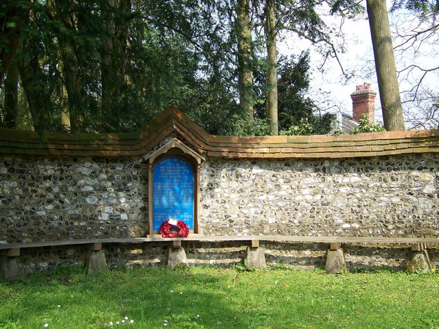
War
Memorial, Wilsford In sylvan surroundings the War Memorial is attractive as well as utilitarian.
871:"}},"text\/plain":{"en":{"P7787":"67 degree"}}}}": -->
803:"}},"text\/plain":{"en":{"P7787":"67 degree"}}}}": -->
91:
724:
709:
532:
325:
8:
269:
253:
203:
1000:
294:
78:
419:
156:
146:
888:
820:
774:
683:
615:
571:
480:
274:
1058:
286:
936:
Click on a date/time to view the file as it appeared at that time.
239:
189:
1018:
1038:
1028:
224:
51° 09′ 27″ N, 1° 48′ 35″ W
174:
51° 09′ 27″ N, 1° 48′ 35″ W
135:
66:
413:
Add a one-line explanation of what this file represents
1048:
994:
116:
War
Memorial, Wilsford - geograph.org.uk - 773899.jpg
52:
War_Memorial,_Wilsford_-_geograph.org.uk_-_773899.jpg
1009:
934:
90:
Commons is a freely licensed media file repository.
622:
Creative
Commons Attribution-ShareAlike 2.0 Generic
596:
Creative
Commons Attribution-ShareAlike 2.0 Generic
56:(640 × 480 pixels, file size: 131 KB, MIME type:
382:https://creativecommons.org/licenses/by-sa/2.0
71:
388:Creative Commons Attribution-Share Alike 2.0
306:
131:
113:
648:https:\/\/www.geograph.org.uk\/photo\/773899
461:https:\/\/www.geograph.org.uk\/profile\/9274
152:
141:
14:
868:
800:
348:– to copy, distribute and transmit the work
1011:The following other wikis use this file:
710:https://www.geograph.org.uk/photo/773899
533:https://www.geograph.org.uk/profile/9274
246:View this and other nearby images on:
196:View this and other nearby images on:
102:
293:and is licensed for reuse under the
214:
164:
996:The following page uses this file:
927:
329:Attribution-Share Alike 2.0 Generic
317:
312:
297:Attribution-ShareAlike 2.0 license.
13:
1069:
1055:Usage on zh-min-nan.wikipedia.org
418:
412:
303:
280:
120:
103:
49:
1095:
1076:
417:
811:coordinates of the point of view
793:coordinates of the point of view
403:
359:Under the following conditions:
324:This file is licensed under the
316:
311:
305:
273:
252:
238:
230:
202:
188:
180:
70:
31:
21:
400:
121:
46:No higher resolution available.
1006:
931:
690:file available on the internet
640:file available on the internet
399:
281:This image was taken from the
26:
1:
879:coordinates of depicted place
861:coordinates of depicted place
36:
991:
740:Geograph Britain and Ireland
664:Geograph Britain and Ireland
498:object of statement has role
445:object of statement has role
425:Items portrayed in this file
265:
7:
1066:
1015:Usage on ceb.wikipedia.org
229:
179:
10:
1100:
1045:Usage on www.wikidata.org
1035:Usage on tr.wikipedia.org
1025:Usage on fr.wikipedia.org
894:51°9'27.07"N, 1°48'34.56"W
826:51°9'27.07"N, 1°48'34.56"W
373:same or compatible license
110:
105:
928:
16:
718:geograph.org.uk image ID
652:geograph.org.uk image ID
402:
339:
77:This is a file from the
41:
985:
964:23:40, 19 February 2011
134:
81:. Information from its
287:this photograph's page
258:51.157520; -1.809600
208:51.157520; -1.809600
84:description page there
354:– to adapt the work
513:author name string
453:author name string
1087:
1086:
1059:Wilsford cum Lake
1039:Wilsford cum Lake
1029:Wilsford cum Lake
1019:Wilsford cum Lake
1007:Global file usage
1001:Wilsford cum Lake
989:
870:
802:
606:copyright license
592:copyright license
411:
302:
301:
285:collection. See
263:
262:
213:
212:
162:
161:
99:
98:
79:Wikimedia Commons
32:Global file usage
1091:
1077:
976:
938:
916:
915:
910:
848:
847:
842:
742:
737:
727:
722:
712:
707:
703:described at URL
644:described at URL
562:copyright status
548:copyright status
535:
530:
520:
517:
507:
502:
409:
395:
392:
389:
386:
383:
375:as the original.
337:
326:Creative Commons
320:
319:
315:
314:
309:
308:
295:Creative Commons
283:Geograph project
277:
270:
259:
256:
242:
241:
235:
234:
233:
227:
226:
215:
209:
206:
192:
191:
185:
184:
183:
177:
176:
165:
137:
125:
117:
111:
95:
74:
73:
67:
61:
59:
1099:
1098:
1094:
1093:
1092:
1090:
1089:
1088:
1065:
1005:
990:
982:
974:
930:
929:
926:
925:
924:
923:
922:
921:
920:
919:
918:
917:
913:
911:
908:
899:
898:
897:
895:
885:
884:
883:
881:
858:
857:
856:
855:
854:
853:
852:
851:
850:
849:
845:
843:
840:
831:
830:
829:
827:
817:
816:
815:
813:
790:
789:
788:
787:
786:
785:
784:
783:
781:
771:
770:
769:
767:
752:
751:
750:
749:
748:
747:
746:
745:
744:
743:
738:
735:
729:
728:
723:
720:
714:
713:
708:
705:
696:
695:
694:
692:
680:
679:
678:
676:
633:
632:
631:
630:
629:
628:
627:
626:
624:
612:
611:
610:
608:
589:
588:
587:
586:
585:
584:
583:
582:
580:
568:
567:
566:
564:
545:
544:
543:
542:
541:
540:
539:
538:
537:
536:
531:
528:
522:
521:
518:
515:
509:
508:
503:
500:
491:
490:
489:
487:
477:
476:
475:
473:
438:
437:
436:
435:
434:
432:
416:
415:
414:
397:
396:
393:
390:
387:
384:
381:
380:
338:
335:
332:
321:
298:
268:
257:
231:
222:
221:
218:Object location
207:
181:
172:
171:
168:Camera location
163:
147:geograph.org.uk
127:
115:
108:
101:
100:
89:
88:
87:is shown below.
63:
57:
55:
48:
47:
12:
11:
5:
1097:
1085:
1084:
1081:
1068:
1064:
1063:
1062:
1061:
1053:
1052:
1051:
1043:
1042:
1041:
1033:
1032:
1031:
1023:
1022:
1021:
1008:
1004:
1003:
993:
988:
987:
984:
980:
977:
971:
966:
961:
957:
956:
953:
950:
947:
944:
941:
933:
904:
903:
902:
901:
900:
896:
893:
891:
890:
889:
887:
886:
882:
877:
875:
874:
873:
872:
866:
862:
836:
835:
834:
833:
832:
828:
825:
823:
822:
821:
819:
818:
814:
809:
807:
806:
805:
804:
798:
794:
782:
779:
777:
776:
775:
773:
772:
768:
763:
761:
760:
759:
758:
756:
731:
730:
716:
715:
701:
700:
699:
698:
697:
693:
688:
686:
685:
684:
682:
681:
677:
674:source of file
672:
670:
669:
668:
667:
665:
661:
657:
653:
649:
645:
641:
637:
636:source of file
625:
620:
618:
617:
616:
614:
613:
609:
604:
602:
601:
600:
599:
597:
593:
581:
576:
574:
573:
572:
570:
569:
565:
560:
558:
557:
556:
555:
553:
549:
524:
523:
511:
510:
496:
495:
494:
493:
492:
488:
485:
483:
482:
481:
479:
478:
474:
469:
467:
466:
465:
464:
462:
458:
454:
450:
446:
442:
433:
428:
426:
423:
422:
421:
420:
408:
407:
404:
401:
379:
378:
377:
376:
366:
357:
356:
355:
349:
342:You are free:
333:
323:
322:
304:
300:
299:
278:
267:
264:
261:
260:
250:
244:
219:
211:
210:
200:
194:
169:
160:
159:
154:
150:
149:
143:
139:
138:
133:
129:
128:
118:
109:
107:
104:
97:
96:
75:
65:
64:
45:
40:
39:
34:
29:
24:
19:
9:
6:
4:
3:
2:
1096:
1082:
1079:
1078:
1075:
1072:
1060:
1057:
1056:
1054:
1050:
1047:
1046:
1044:
1040:
1037:
1036:
1034:
1030:
1027:
1026:
1024:
1020:
1017:
1016:
1014:
1013:
1012:
1002:
999:
998:
997:
983:
978:
972:
970:
967:
965:
962:
959:
958:
954:
951:
948:
945:
942:
940:
939:
937:
907:
892:
880:
876:
839:
824:
812:
808:
780:22 April 2008
778:
766:
762:
741:
734:
726:
719:
711:
704:
691:
687:
675:
671:
623:
619:
607:
603:
579:
575:
563:
559:
534:
527:
514:
506:
499:
484:
472:
468:
431:
427:
424:
405:
398:
385:CC BY-SA 2.0
374:
370:
367:
364:
361:
360:
358:
353:
350:
347:
344:
343:
341:
340:
334:Attribution:
330:
327:
310:
296:
292:
288:
284:
279:
276:
272:
271:
255:
251:
249:
248:OpenStreetMap
245:
243:
225:
220:
217:
216:
205:
201:
199:
198:OpenStreetMap
195:
193:
175:
170:
167:
166:
158:
155:
151:
148:
144:
140:
136:22 April 2008
130:
124:
119:
112:
93:
86:
85:
80:
76:
69:
68:
62:
53:
44:
38:
35:
33:
30:
28:
25:
23:
20:
18:
15:
1073:
1070:
1010:
995:
935:
932:File history
505:photographer
449:photographer
368:
362:
351:
345:
290:
228:
178:
122:
92:You can help
82:
50:
22:File history
981:GeographBot
578:copyrighted
552:copyrighted
519:Trish Steel
369:share alike
363:attribution
336:Trish Steel
291:Trish Steel
157:Trish Steel
114:Description
1080:_error
992:File usage
973:640 × 480
949:Dimensions
486:some value
58:image/jpeg
27:File usage
946:Thumbnail
943:Date/Time
765:inception
755:inception
266:Licensing
123:English:
1067:Metadata
1049:Q2370316
975:(131 KB)
733:operator
660:operator
406:Captions
352:to remix
346:to share
331:license.
37:Metadata
960:current
955:Comment
906:heading
865:heading
838:heading
797:heading
471:creator
441:creator
430:depicts
410:English
106:Summary
54:
914:degree
869:degree
846:degree
801:degree
725:773899
656:773899
236:
186:
153:Author
142:Source
145:From
952:User
394:true
391:true
132:Date
17:File
912:67
844:67
526:URL
457:URL
909::
841::
736::
721::
706::
529::
516::
501::
1083:0
94:.
60:)
_heading:67.00&language=en)
_heading:67.00&language=en)
