439:"}},"text\/plain":{"en":{"":"coordinates of the point of view"}}},"{\"value\":{\"latitude\":52.7074,\"longitude\":-2.956,\"altitude\":null,\"precision\":0.0001,\"globe\":\"http:\\\/\\\/www.wikidata.org\\\/entity\\\/Q2\"},\"type\":\"globecoordinate\"}":{"text\/html":{"en":{"P1259":"52\u00b042'26.6"N, 2\u00b057'21.6"W"}},"text\/plain":{"en":{"P1259":"52\u00b042'26.6\"N, 2\u00b057'21.6\"W"}}}}": -->
401:"}},"text\/plain":{"en":{"":"inception"}}},"{\"value\":{\"time\":\"+2015-01-02T00:00:00Z\",\"timezone\":0,\"before\":0,\"after\":0,\"precision\":11,\"calendarmodel\":\"http:\\\/\\\/www.wikidata.org\\\/entity\\\/Q1985727\"},\"type\":\"time\"}":{"text\/html":{"en":{"P571":"2 January 2015"}},"text\/plain":{"en":{"P571":"2 January 2015"}}}}": -->
193:
243:
207:
318:
293:
86:
38:
435:
226:
on the
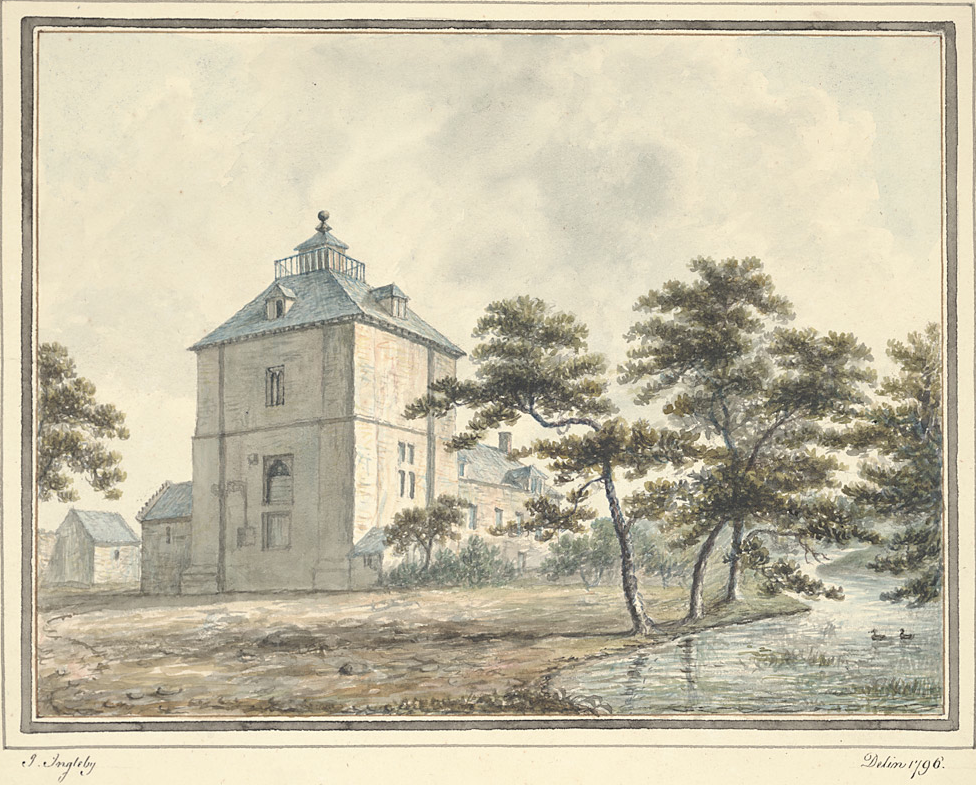
Shrewsbury to Welshpool road, the castle was probably built in the late 13th century for Sir Richard Corbet. It comprised a square two storey tower surrounded by a moated enclosure with a fishpond.
190:
184:
230:
It was bought by the
Leighton family circa 1501 and used as their chief residence until circa 1711. At that time an adjoining farm building was constructed and named Wattlesborough Hall.
223:
436:
219:
323:
398:
52:
48:
42:
97:
65:
556:
333:
This file has been identified as being free of known restrictions under copyright law, including all related and neighboring rights.
200:
306:
257:
446:
408:
387:
561:
599:
159:
566:
546:
514:
509:
56:
37:
105:
571:
332:
8:
206:
551:
92:
377:
301:
160:
http://digidol.llgc.org.uk/METS/ING00001/ingleviewer?item=171&locale=cy
456:
418:
242:
525:
326:
to indicate why this work is in the public domain in the United States.
482:
Click on a date/time to view the file as it appeared at that time.
604:
589:
305:
in its country of origin and other countries and areas where the
192:
185:
52° 42′ 26.64″ N, 2° 57′ 21.6″ W
253:
600:
Liste von Burgen und Schlössern im
Vereinigten Königreich
149:
80:
371:
Add a one-line explanation of what this file represents
540:
580:
480:
104:
Commons is a freely licensed media file repository.
341:https://creativecommons.org/publicdomain/mark/1.0/
70:(976 × 785 pixels, file size: 1.14 MB, MIME type:
85:
145:
127:
557:Listed buildings in Alberbury with Cardeston
165:
155:
14:
582:The following other wikis use this file:
347:Creative Commons Public Domain Mark 1.0
199:View this and other nearby images on:
542:The following 6 pages use this file:
292:
116:
287:
175:
130:Wattlesborough Tower, Shropshire.png
532:User created page with UploadWizard
473:
13:
376:
370:
241:
134:
117:
63:
618:
375:
562:Sir Edward Leighton, 1st Baronet
447:coordinates of the point of view
437:coordinates of the point of view
361:
316:
291:
256:. The website is managed by the
205:
191:
140:Wattlesborough Tower, Shropshire
84:
31:
21:
358:
324:United States public domain tag
135:
577:
477:
357:
26:
1:
537:
383:Items portrayed in this file
311:life plus 100 years or fewer
233:
7:
567:Thomas Leighton (died 1600)
547:Edward Leighton (died 1593)
252:The source of this file is
10:
623:
596:Usage on de.wikipedia.org
586:Usage on da.wikipedia.org
254:http://www.llgc.org.uk/en/
169:John Ingleby, artist 1796
124:
119:
474:
462:52°42'26.6"N, 2°57'21.6"W
331:
290:
258:National Library of Wales
240:
16:
360:
322:You must also include a
220:Alberbury with Cardeston
91:This is a file from the
36:
531:
148:
95:. Information from its
246:
222:, near the village of
211:52.707400; -2.956000
98:description page there
41:Size of this preview:
605:Wattlesborough Castle
590:Wattlesborough Castle
572:Wattlesborough Castle
510:22:21, 2 January 2015
245:
299:This work is in the
47:Other resolutions:
247:
578:Global file usage
552:Leighton baronets
535:
369:
338:
337:
327:
286:
285:
266:
265:
218:In the parish of
216:
215:
173:
172:
113:
112:
93:Wikimedia Commons
32:Global file usage
614:
522:
484:
367:
354:
351:
348:
345:
342:
321:
320:
319:
309:is the author's
295:
294:
288:
282:
279:
276:
273:
268:
267:
238:
237:
212:
209:
195:
194:
188:
187:
176:
151:
139:
131:
125:
109:
88:
87:
81:
75:
73:
60:
57:976 × 785 pixels
53:597 × 480 pixels
49:299 × 240 pixels
43:745 × 599 pixels
622:
621:
617:
616:
615:
613:
612:
611:
576:
536:
528:
520:
476:
475:
472:
471:
470:
469:
468:
467:
466:
465:
463:
453:
452:
451:
449:
434:
433:
432:
431:
430:
429:
428:
427:
425:
415:
414:
413:
411:
396:
395:
394:
393:
392:
390:
374:
373:
372:
352:
349:
346:
343:
340:
317:
280:
277:
274:
271:
262:
236:
210:
183:
182:
179:Camera location
174:
141:
129:
122:
115:
114:
103:
102:
101:is shown below.
77:
71:
69:
62:
61:
46:
12:
11:
5:
620:
610:
609:
608:
607:
602:
594:
593:
592:
579:
575:
574:
569:
564:
559:
554:
549:
539:
534:
533:
530:
526:
523:
517:
512:
507:
503:
502:
499:
496:
493:
490:
487:
479:
464:
461:
459:
458:
457:
455:
454:
450:
445:
443:
442:
441:
440:
438:
426:
424:2 January 2015
423:
421:
420:
419:
417:
416:
412:
407:
405:
404:
403:
402:
400:
391:
386:
384:
381:
380:
379:
378:
366:
365:
362:
359:
336:
335:
329:
328:
307:copyright term
296:
284:
283:
264:
263:
250:
248:
235:
232:
214:
213:
203:
197:
180:
171:
170:
167:
163:
162:
157:
153:
152:
150:2 January 2015
147:
143:
142:
132:
123:
121:
118:
111:
110:
89:
79:
78:
40:
35:
34:
29:
24:
19:
9:
6:
4:
3:
2:
619:
606:
603:
601:
598:
597:
595:
591:
588:
587:
585:
584:
583:
573:
570:
568:
565:
563:
560:
558:
555:
553:
550:
548:
545:
544:
543:
529:
524:
518:
516:
513:
511:
508:
505:
504:
500:
497:
494:
491:
488:
486:
485:
483:
460:
448:
444:
422:
410:
406:
389:
385:
382:
363:
356:
355:
334:
330:
325:
315:
314:
312:
308:
304:
303:
302:public domain
297:
289:
275:Public domain
272:Public domain
270:
269:
261:
259:
255:
249:
244:
239:
231:
228:
225:
224:Halfway House
221:
208:
204:
202:
201:OpenStreetMap
198:
196:
186:
181:
178:
177:
168:
164:
161:
158:
154:
144:
138:
133:
126:
107:
100:
99:
94:
90:
83:
82:
76:
67:
66:Original file
58:
54:
50:
44:
39:
33:
30:
28:
25:
23:
20:
18:
15:
581:
541:
481:
478:File history
339:
310:
300:
298:
251:
229:
217:
136:
106:You can help
96:
64:
22:File history
128:Description
538:File usage
519:976 × 785
495:Dimensions
27:File usage
521:(1.14 MB)
492:Thumbnail
489:Date/Time
409:inception
399:inception
234:Licensing
137:English:
72:image/png
364:Captions
506:current
501:Comment
388:depicts
368:English
120:Summary
68:
527:Tyssil
189:
166:Author
156:Source
353:false
350:false
281:false
278:false
498:User
146:Date
17:File
344:PDM
313:.
260:.
55:|
51:|
45:.
108:.
74:)
59:.
