765:"}},"text\/plain":{"en":{"":"coordinates of the point of view"}}},"{\"value\":{\"latitude\":51.53941,\"longitude\":-1.31651,\"altitude\":null,\"precision\":1.0e-5,\"globe\":\"http:\\\/\\\/www.wikidata.org\\\/entity\\\/Q2\"},\"type\":\"globecoordinate\"}":{"text\/html":{"en":{"P1259":"51\u00b032'21.88"N, 1\u00b018'59.44"W"}},"text\/plain":{"en":{"P1259":"51\u00b032'21.88\"N, 1\u00b018'59.44\"W"}}}}": -->
425:"}},"text\/plain":{"en":{"":"author name string"}}},"{\"value\":\"Pam Brophy\",\"type\":\"string\"}":{"text\/html":{"en":{"P2093":"Pam Brophy"}},"text\/plain":{"en":{"P2093":"Pam Brophy"}}},"{\"value\":{\"entity-type\":\"property\",\"numeric-id\":2699,\"id\":\"P2699\"},\"type\":\"wikibase-entityid\"}":{"text\/html":{"en":{"":"
727:"}},"text\/plain":{"en":{"":"inception"}}},"{\"value\":{\"time\":\"+2005-04-24T00:00:00Z\",\"timezone\":0,\"before\":0,\"after\":0,\"precision\":11,\"calendarmodel\":\"http:\\\/\\\/www.wikidata.org\\\/entity\\\/Q1985727\"},\"type\":\"time\"}":{"text\/html":{"en":{"P571":"24 April 2005"}},"text\/plain":{"en":{"P571":"24 April 2005"}}}}": -->
604:
409:
224:
245:
283:
288:
72:
612:"}},"text\/plain":{"en":{"P7482":"file available on the internet"}}},"{\"value\":{\"entity-type\":\"property\",\"numeric-id\":7384,\"id\":\"P7384\"},\"type\":\"wikibase-entityid\"}":{"text\/html":{"en":{"":"
417:"}},"text\/plain":{"en":{"":"object of statement has role"}}},"{\"value\":{\"entity-type\":\"item\",\"numeric-id\":33231,\"id\":\"Q33231\"},\"type\":\"wikibase-entityid\"}":{"text\/html":{"en":{"P3831":"
628:"}},"text\/plain":{"en":{"P137":"Geograph Britain and Ireland"}}},"{\"value\":{\"entity-type\":\"property\",\"numeric-id\":973,\"id\":\"P973\"},\"type\":\"wikibase-entityid\"}":{"text\/html":{"en":{"":"
564:"}},"text\/plain":{"en":{"":"copyright license"}}},"{\"value\":{\"entity-type\":\"item\",\"numeric-id\":19068220,\"id\":\"Q19068220\"},\"type\":\"wikibase-entityid\"}":{"text\/html":{"en":{"P275":"
520:"}},"text\/plain":{"en":{"":"copyright status"}}},"{\"value\":{\"entity-type\":\"item\",\"numeric-id\":50423863,\"id\":\"Q50423863\"},\"type\":\"wikibase-entityid\"}":{"text\/html":{"en":{"P6216":"
608:"}},"text\/plain":{"en":{"":"source of file"}}},"{\"value\":{\"entity-type\":\"item\",\"numeric-id\":74228490,\"id\":\"Q74228490\"},\"type\":\"wikibase-entityid\"}":{"text\/html":{"en":{"P7482":"
421:"}},"text\/plain":{"en":{"P3831":"photographer"}}},"{\"value\":{\"entity-type\":\"property\",\"numeric-id\":2093,\"id\":\"P2093\"},\"type\":\"wikibase-entityid\"}":{"text\/html":{"en":{"":"
624:"}},"text\/plain":{"en":{"":"operator"}}},"{\"value\":{\"entity-type\":\"item\",\"numeric-id\":1503119,\"id\":\"Q1503119\"},\"type\":\"wikibase-entityid\"}":{"text\/html":{"en":{"P137":"
620:"}},"text\/plain":{"en":{"P7384":"5596"}}},"{\"value\":{\"entity-type\":\"property\",\"numeric-id\":137,\"id\":\"P137\"},\"type\":\"wikibase-entityid\"}":{"text\/html":{"en":{"":"
413:"}},"text\/plain":{"en":{"":"creator"}}},"{\"value\":{\"entity-type\":\"property\",\"numeric-id\":3831,\"id\":\"P3831\"},\"type\":\"wikibase-entityid\"}":{"text\/html":{"en":{"":"
761:
632:"}},"text\/plain":{"en":{"":"described at URL"}}},"{\"value\":\"https:\\\/\\\/www.geograph.org.uk\\\/photo\\\/5596\",\"type\":\"string\"}":{"text\/html":{"en":{"P973":"
429:"}},"text\/plain":{"en":{"":"URL"}}},"{\"value\":\"https:\\\/\\\/www.geograph.org.uk\\\/profile\\\/40\",\"type\":\"string\"}":{"text\/html":{"en":{"P2699":"
616:"}},"text\/plain":{"en":{"":"geograph.org.uk image ID"}}},"{\"value\":\"5596\",\"type\":\"string\"}":{"text\/html":{"en":{"P7384":"
43:
335:– You must give appropriate credit, provide a link to the license, and indicate if changes were made. You may do so in any reasonable manner, but not in any way that suggests the licensor endorses you or your use.
207:
201:
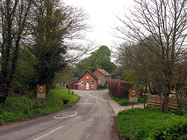
138:. This attractive village is a little gem in the area. This end of the village is situated in the south eastern section of the grid square, taken from the road looking north east.
609:
565:
521:
625:
617:
418:
762:
613:
605:
517:
426:
422:
414:
724:
629:
621:
561:
410:
851:
633:
430:
568:"}},"text\/plain":{"en":{"P275":"Creative Commons Attribution-ShareAlike 2.0 Generic"}}}}": -->
179:
433:"}},"text\/plain":{"en":{"P2699":"https:\/\/www.geograph.org.uk\/profile\/40"}}}}": -->
636:"}},"text\/plain":{"en":{"P973":"https:\/\/www.geograph.org.uk\/photo\/5596"}}}}": -->
83:
51:
659:
591:
547:
217:
694:
252:
935:
This file contains additional information, probably added from the digital camera or scanner used to create or digitize it.
342:
474:
772:
672:
643:
531:
495:
482:
467:
734:
702:
687:
575:
440:
399:
298:
938:
If the file has been modified from its original state, some details may not fully reflect the modified file.
341:– If you remix, transform, or build upon the material, you must distribute your contributions under the
259:
on the
Geograph website for the photographer's contact details. The copyright on this image is owned by
524:"}},"text\/plain":{"en":{"P6216":"copyrighted"}}}}": -->
902:
870:. :From http://www.geograph.co.uk/photo/5596, taken by . :Taken on 24/04/2005. {{cc-by-sa-2.0}}
91:
840:
835:
42:
295:
8:
709:
679:
502:
239:
223:
264:
78:
389:
127:
884:
859:
244:
168:
158:
782:
744:
653:
585:
541:
450:
131:
863:
808:
Click on a date/time to view the file as it appeared at that time.
256:
135:
867:
209:
202:
51° 32′ 21.88″ N, 1° 18′ 59.44″ W
147:
66:
922:
912:
858:* '''en''': :An image of
383:
Add a one-line explanation of what this file represents
878:
893:
806:
186:
Creative
Commons Attribution Share-alike license 2.0
90:
Commons is a freely licensed media file repository.
592:
Creative
Commons Attribution-ShareAlike 2.0 Generic
566:
Creative
Commons Attribution-ShareAlike 2.0 Generic
56:(640 × 480 pixels, file size: 522 KB, MIME type:
352:https://creativecommons.org/licenses/by-sa/2.0
71:
358:Creative Commons Attribution-Share Alike 2.0
276:
174:
143:
113:
164:
153:
14:
318:– to copy, distribute and transmit the work
634:https:\/\/www.geograph.org.uk\/photo\/5596
431:https:\/\/www.geograph.org.uk\/profile\/40
895:The following other wikis use this file:
710:https://www.geograph.org.uk/photo/5596
503:https://www.geograph.org.uk/profile/40
216:View this and other nearby images on:
102:
947:File written by Adobe Photoshop¨ 4.0
263:and is licensed for reuse under the
192:
880:The following page uses this file:
799:
299:Attribution-Share Alike 2.0 Generic
287:
282:
267:Attribution-ShareAlike 2.0 license.
13:
933:
388:
382:
273:
250:
120:
103:
49:
959:
940:
387:
773:coordinates of the point of view
763:coordinates of the point of view
373:
329:Under the following conditions:
294:This file is licensed under the
286:
281:
275:
243:
222:
208:
70:
31:
21:
370:
121:
46:No higher resolution available.
890:
803:
660:file available on the internet
610:file available on the internet
369:
251:This image was taken from the
26:
1:
36:
875:
695:Geograph Britain and Ireland
626:Geograph Britain and Ireland
468:object of statement has role
415:object of statement has role
395:Items portrayed in this file
235:
7:
930:
788:51°32'21.88"N, 1°18'59.44"W
10:
964:
919:Usage on tr.wikipedia.org
909:Usage on la.wikipedia.org
899:Usage on fa.wikipedia.org
343:same or compatible license
116:West Ilsley, Berkshire.jpg
110:
105:
52:West_Ilsley,_Berkshire.jpg
800:
16:
673:geograph.org.uk image ID
614:geograph.org.uk image ID
372:
309:
77:This is a file from the
41:
857:
146:
81:. Information from its
257:this photograph's page
228:51.539410; -1.316510
84:description page there
324:– to adapt the work
836:01:23, 7 June 2005
483:author name string
423:author name string
951:
950:
944:JPEG file comment
891:Global file usage
873:
853:Joolz~commonswiki
576:copyright license
562:copyright license
381:
272:
271:
255:collection. See
233:
232:
190:
189:
183:
180:Reusing this file
99:
98:
79:Wikimedia Commons
32:Global file usage
955:
941:
848:
810:
712:
707:
703:described at URL
697:
692:
682:
677:
630:described at URL
532:copyright status
518:copyright status
505:
500:
490:
487:
477:
472:
379:
365:
362:
359:
356:
353:
345:as the original.
307:
296:Creative Commons
290:
289:
285:
284:
279:
278:
265:Creative Commons
253:Geograph project
247:
240:
229:
226:
212:
211:
205:
204:
193:
177:
149:
125:
117:
111:
95:
74:
73:
67:
61:
59:
963:
962:
958:
957:
956:
954:
953:
952:
929:
889:
874:
854:
846:
802:
801:
798:
797:
796:
795:
794:
793:
792:
791:
789:
779:
778:
777:
775:
760:
759:
758:
757:
756:
755:
754:
753:
751:
741:
740:
739:
737:
722:
721:
720:
719:
718:
717:
716:
715:
714:
713:
708:
705:
699:
698:
693:
690:
684:
683:
678:
675:
666:
665:
664:
662:
650:
649:
648:
646:
603:
602:
601:
600:
599:
598:
597:
596:
594:
582:
581:
580:
578:
559:
558:
557:
556:
555:
554:
553:
552:
550:
538:
537:
536:
534:
515:
514:
513:
512:
511:
510:
509:
508:
507:
506:
501:
498:
492:
491:
488:
485:
479:
478:
473:
470:
461:
460:
459:
457:
447:
446:
445:
443:
408:
407:
406:
405:
404:
402:
386:
385:
384:
367:
366:
363:
360:
357:
354:
351:
350:
308:
305:
302:
291:
268:
238:
227:
200:
199:
196:Camera location
191:
159:geograph.org.uk
139:
115:
108:
101:
100:
89:
88:
87:is shown below.
63:
57:
55:
48:
47:
12:
11:
5:
961:
949:
948:
945:
932:
928:
927:
926:
925:
917:
916:
915:
907:
906:
905:
892:
888:
887:
877:
872:
871:
860:en:West Ilsley
856:
852:
849:
843:
838:
833:
829:
828:
825:
822:
819:
816:
813:
805:
790:
787:
785:
784:
783:
781:
780:
776:
771:
769:
768:
767:
766:
764:
752:
749:
747:
746:
745:
743:
742:
738:
733:
731:
730:
729:
728:
726:
701:
700:
686:
685:
671:
670:
669:
668:
667:
663:
658:
656:
655:
654:
652:
651:
647:
644:source of file
642:
640:
639:
638:
637:
635:
631:
627:
623:
619:
615:
611:
607:
606:source of file
595:
590:
588:
587:
586:
584:
583:
579:
574:
572:
571:
570:
569:
567:
563:
551:
546:
544:
543:
542:
540:
539:
535:
530:
528:
527:
526:
525:
523:
519:
494:
493:
481:
480:
466:
465:
464:
463:
462:
458:
455:
453:
452:
451:
449:
448:
444:
439:
437:
436:
435:
434:
432:
428:
424:
420:
416:
412:
403:
398:
396:
393:
392:
391:
390:
378:
377:
374:
371:
349:
348:
347:
346:
336:
327:
326:
325:
319:
312:You are free:
303:
293:
292:
274:
270:
269:
248:
237:
234:
231:
230:
220:
214:
197:
188:
187:
184:
172:
171:
166:
162:
161:
155:
151:
150:
145:
141:
140:
118:
109:
107:
104:
97:
96:
75:
65:
64:
45:
40:
39:
34:
29:
24:
19:
9:
6:
4:
3:
2:
960:
946:
943:
942:
939:
936:
924:
921:
920:
918:
914:
911:
910:
908:
904:
901:
900:
898:
897:
896:
886:
883:
882:
881:
869:
865:
861:
855:
850:
844:
842:
839:
837:
834:
831:
830:
826:
823:
820:
817:
814:
812:
811:
809:
786:
774:
770:
750:24 April 2005
748:
736:
732:
711:
704:
696:
689:
681:
674:
661:
657:
645:
641:
593:
589:
577:
573:
549:
545:
533:
529:
504:
497:
484:
476:
469:
454:
442:
438:
401:
397:
394:
375:
368:
355:CC BY-SA 2.0
344:
340:
337:
334:
331:
330:
328:
323:
320:
317:
314:
313:
311:
310:
304:Attribution:
300:
297:
280:
266:
262:
258:
254:
249:
246:
242:
241:
225:
221:
219:
218:OpenStreetMap
215:
213:
203:
198:
195:
194:
185:
181:
176:
173:
170:
167:
163:
160:
156:
152:
148:24 April 2005
142:
137:
133:
129:
124:
119:
112:
93:
86:
85:
80:
76:
69:
68:
62:
53:
44:
38:
35:
33:
30:
28:
25:
23:
20:
18:
15:
937:
934:
894:
879:
864:en:Berkshire
807:
804:File history
475:photographer
419:photographer
338:
332:
321:
315:
260:
126:Approach to
122:
92:You can help
82:
50:
22:File history
923:West Ilsley
913:West Ilsley
885:West Ilsley
548:copyrighted
522:copyrighted
339:share alike
333:attribution
128:West Ilsley
114:Description
903:وست ایلزلی
876:File usage
868:en:England
845:640 × 480
821:Dimensions
489:Pam Brophy
456:some value
306:Pam Brophy
261:Pam Brophy
175:Permission
169:Pam Brophy
58:image/jpeg
27:File usage
818:Thumbnail
815:Date/Time
735:inception
725:inception
236:Licensing
132:Berkshire
123:English:
931:Metadata
847:(522 KB)
688:operator
622:operator
376:Captions
322:to remix
316:to share
301:license.
37:Metadata
832:current
827:Comment
441:creator
411:creator
400:depicts
380:English
136:England
106:Summary
54:
206:
165:Author
154:Source
157:From
824:User
680:5596
618:5596
364:true
361:true
144:Date
17:File
862:in
496:URL
427:URL
130:in
866:,
706::
691::
676::
499::
486::
471::
134:,
182:)
178:(
94:.
60:)
