816:"}},"text\/plain":{"en":{"":"coordinates of the point of view"}}},"{\"value\":{\"latitude\":52.18675,\"longitude\":-2.214241,\"altitude\":null,\"precision\":1.0e-6,\"globe\":\"http:\\\/\\\/www.wikidata.org\\\/entity\\\/Q2\"},\"type\":\"globecoordinate\"}":{"text\/html":{"en":{"P1259":"52\u00b011'12.300"N, 2\u00b012'51.268"W"}},"text\/plain":{"en":{"P1259":"52\u00b011'12.300\"N, 2\u00b012'51.268\"W"}}},"{\"value\":{\"entity-type\":\"property\",\"numeric-id\":7787,\"id\":\"P7787\"},\"type\":\"wikibase-entityid\"}":{"text\/html":{"en":{"":"
476:"}},"text\/plain":{"en":{"":"author name string"}}},"{\"value\":\"Philip Halling\",\"type\":\"string\"}":{"text\/html":{"en":{"P2093":"Philip Halling"}},"text\/plain":{"en":{"P2093":"Philip Halling"}}},"{\"value\":{\"entity-type\":\"property\",\"numeric-id\":2699,\"id\":\"P2699\"},\"type\":\"wikibase-entityid\"}":{"text\/html":{"en":{"":"
778:"}},"text\/plain":{"en":{"":"inception"}}},"{\"value\":{\"time\":\"+2013-09-04T00:00:00Z\",\"timezone\":0,\"before\":0,\"after\":0,\"precision\":11,\"calendarmodel\":\"http:\\\/\\\/www.wikidata.org\\\/entity\\\/Q1985727\"},\"type\":\"time\"}":{"text\/html":{"en":{"P571":"4 September 2013"}},"text\/plain":{"en":{"P571":"4 September 2013"}}}}": -->
655:
38:
261:
253:
812:
296:
334:
339:
86:
663:"}},"text\/plain":{"en":{"P7482":"file available on the internet"}}},"{\"value\":{\"entity-type\":\"property\",\"numeric-id\":137,\"id\":\"P137\"},\"type\":\"wikibase-entityid\"}":{"text\/html":{"en":{"":"
671:"}},"text\/plain":{"en":{"P137":"Geograph Britain and Ireland"}}},"{\"value\":{\"entity-type\":\"property\",\"numeric-id\":7384,\"id\":\"P7384\"},\"type\":\"wikibase-entityid\"}":{"text\/html":{"en":{"":"
468:"}},"text\/plain":{"en":{"":"object of statement has role"}}},"{\"value\":{\"entity-type\":\"item\",\"numeric-id\":33231,\"id\":\"Q33231\"},\"type\":\"wikibase-entityid\"}":{"text\/html":{"en":{"P3831":"
615:"}},"text\/plain":{"en":{"":"copyright license"}}},"{\"value\":{\"entity-type\":\"item\",\"numeric-id\":19068220,\"id\":\"Q19068220\"},\"type\":\"wikibase-entityid\"}":{"text\/html":{"en":{"P275":"
571:"}},"text\/plain":{"en":{"":"copyright status"}}},"{\"value\":{\"entity-type\":\"item\",\"numeric-id\":50423863,\"id\":\"Q50423863\"},\"type\":\"wikibase-entityid\"}":{"text\/html":{"en":{"P6216":"
659:"}},"text\/plain":{"en":{"":"source of file"}}},"{\"value\":{\"entity-type\":\"item\",\"numeric-id\":74228490,\"id\":\"Q74228490\"},\"type\":\"wikibase-entityid\"}":{"text\/html":{"en":{"P7482":"
472:"}},"text\/plain":{"en":{"P3831":"photographer"}}},"{\"value\":{\"entity-type\":\"property\",\"numeric-id\":2093,\"id\":\"P2093\"},\"type\":\"wikibase-entityid\"}":{"text\/html":{"en":{"":"
820:"}},"text\/plain":{"en":{"":"heading"}}},"{\"value\":{\"amount\":\"+292\",\"unit\":\"http:\\\/\\\/www.wikidata.org\\\/entity\\\/Q28390\"},\"type\":\"quantity\"}":{"text\/html":{"en":{"P7787":"292
667:"}},"text\/plain":{"en":{"":"operator"}}},"{\"value\":{\"entity-type\":\"item\",\"numeric-id\":1503119,\"id\":\"Q1503119\"},\"type\":\"wikibase-entityid\"}":{"text\/html":{"en":{"P137":"
679:"}},"text\/plain":{"en":{"P7384":"3643569"}}},"{\"value\":{\"entity-type\":\"property\",\"numeric-id\":973,\"id\":\"P973\"},\"type\":\"wikibase-entityid\"}":{"text\/html":{"en":{"":"
464:"}},"text\/plain":{"en":{"":"creator"}}},"{\"value\":{\"entity-type\":\"property\",\"numeric-id\":3831,\"id\":\"P3831\"},\"type\":\"wikibase-entityid\"}":{"text\/html":{"en":{"":"
567:
922:
683:"}},"text\/plain":{"en":{"":"described at URL"}}},"{\"value\":\"https:\\\/\\\/www.geograph.org.uk\\\/photo\\\/3643569\",\"type\":\"string\"}":{"text\/html":{"en":{"P973":"
480:"}},"text\/plain":{"en":{"":"URL"}}},"{\"value\":\"https:\\\/\\\/www.geograph.org.uk\\\/profile\\\/1837\",\"type\":\"string\"}":{"text\/html":{"en":{"P2699":"
675:"}},"text\/plain":{"en":{"":"geograph.org.uk image ID"}}},"{\"value\":\"3643569\",\"type\":\"string\"}":{"text\/html":{"en":{"P7384":"
386:– You must give appropriate credit, provide a link to the license, and indicate if changes were made. You may do so in any reasonable manner, but not in any way that suggests the licensor endorses you or your use.
1291:
258:
244:
676:
660:
616:
572:
668:
469:
932:
817:
813:
672:
656:
568:
477:
473:
465:
684:
775:
680:
664:
612:
481:
461:
1036:
1470:
988:
52:
48:
42:
97:
65:
619:"}},"text\/plain":{"en":{"P275":"Creative Commons Attribution-ShareAlike 2.0 Generic"}}}}": -->
1461:
1286:
181:
687:"}},"text\/plain":{"en":{"P973":"https:\/\/www.geograph.org.uk\/photo\/3643569"}}}}": -->
484:"}},"text\/plain":{"en":{"P2699":"https:\/\/www.geograph.org.uk\/profile\/1837"}}}}": -->
710:
642:
598:
268:
730:
951:
946:
303:
1441:
393:
525:
858:
831:
738:
694:
582:
546:
533:
518:
1276:
785:
753:
723:
626:
491:
450:
349:
392:– If you remix, transform, or build upon the material, you must distribute your contributions under the
310:
on the
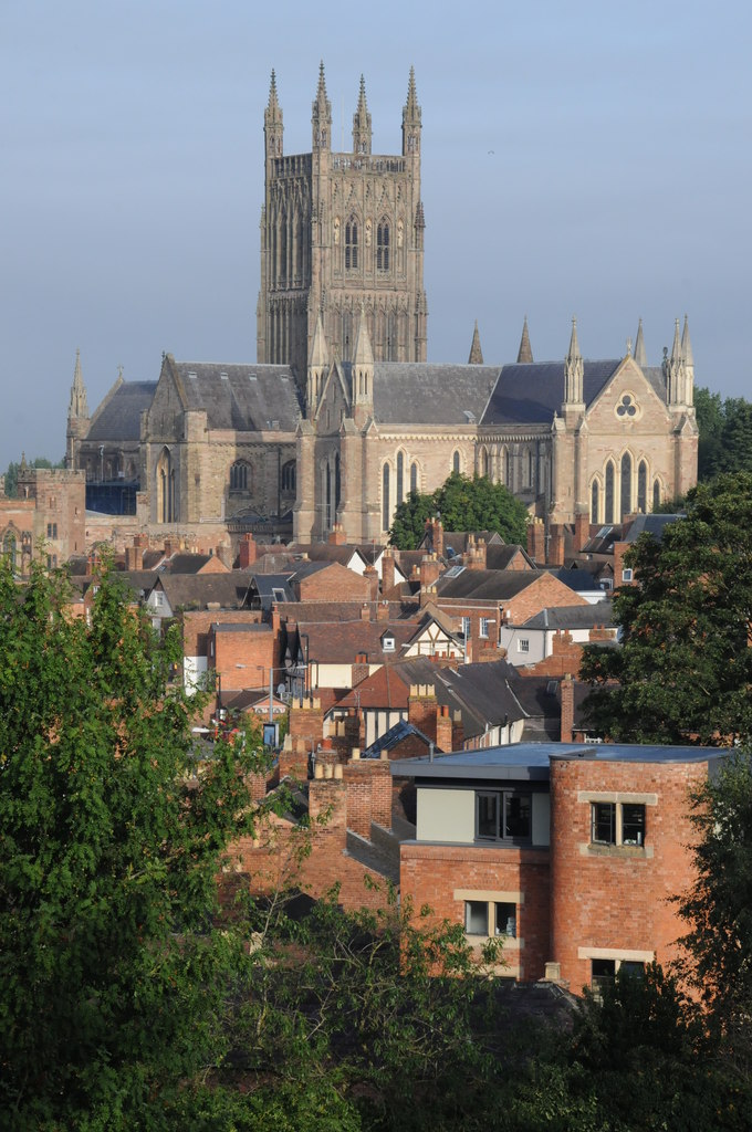
Geograph website for the photographer's contact details. The copyright on this image is owned by
998:
575:"}},"text\/plain":{"en":{"P6216":"copyrighted"}}}}": -->
1096:
921:
916:
824:"}},"text\/plain":{"en":{"P7787":"292 degree"}}}}": -->
56:
37:
105:
213:
760:
745:
553:
346:
197:
1301:
8:
983:
962:
290:
1171:
993:
274:
315:
92:
440:
1351:
1046:
1431:
1381:
1076:
1391:
1066:
160:
170:
841:
795:
704:
636:
592:
501:
1442:
Användare:Lsjbot/Dubletter/Worcester (grevskapshuvudort i
Storbritannien)
295:
307:
1341:
1181:
1256:
1196:
889:
Click on a date/time to view the file as it appeared at that time.
1191:
1151:
1361:
1101:
1016:
260:
1126:
245:
52° 11′ 12.3″ N, 2° 12′ 51.27″ W
1371:
1186:
1146:
1056:
1026:
1221:
149:
80:
1121:
1246:
1161:
1451:
1421:
1411:
1401:
1321:
1311:
1266:
1236:
1226:
1211:
1201:
1136:
1111:
1097:
Worcester (kapital sa kondado sa
Hiniusang Gingharian)
1086:
989:
List of tallest church buildings in the United
Kingdom
1331:
977:
1007:
887:
188:
Creative
Commons Attribution Share-alike license 2.0
104:
Commons is a freely licensed media file repository.
643:
Creative
Commons Attribution-ShareAlike 2.0 Generic
617:
Creative
Commons Attribution-ShareAlike 2.0 Generic
70:(680 × 1,024 pixels, file size: 188 KB, MIME type:
434:A view of Worcester Cathedral from Fort Royal Hill
403:https://creativecommons.org/licenses/by-sa/2.0
85:
685:https:\/\/www.geograph.org.uk\/photo\/3643569
409:Creative Commons Attribution-Share Alike 2.0
327:
176:
145:
127:
482:https:\/\/www.geograph.org.uk\/profile\/1837
166:
155:
14:
821:
369:– to copy, distribute and transmit the work
1009:The following other wikis use this file:
761:https://www.geograph.org.uk/photo/3643569
939:Higher-resolution version from Geograph.
554:https://www.geograph.org.uk/profile/1837
267:View this and other nearby images on:
979:The following 4 pages use this file:
220:
116:
314:and is licensed for reuse under the
235:
969:User created page with UploadWizard
880:
350:Attribution-Share Alike 2.0 Generic
338:
333:
318:Attribution-ShareAlike 2.0 license.
13:
439:
433:
324:
301:
134:
130:Worcester from Fort Royal Hill.jpg
117:
63:
1482:
438:
832:coordinates of the point of view
814:coordinates of the point of view
424:
380:Under the following conditions:
345:This file is licensed under the
337:
332:
326:
294:
273:
259:
251:
84:
31:
21:
421:
135:
1302:Worcester (Egyesült Királyság)
1004:
884:
711:file available on the internet
661:file available on the internet
420:
302:This image was taken from the
26:
1:
847:52°11'12.300"N, 2°12'51.268"W
974:
731:Geograph Britain and Ireland
669:Geograph Britain and Ireland
519:object of statement has role
466:object of statement has role
446:Items portrayed in this file
286:
250:
7:
1388:Usage on pnb.wikipedia.org
1368:Usage on nrm.wikipedia.org
1348:Usage on mzn.wikipedia.org
1338:Usage on lld.wikipedia.org
1273:Usage on he.wikivoyage.org
1253:Usage on fr.wikivoyage.org
1243:Usage on frr.wikipedia.org
1178:Usage on en.wikivoyage.org
1158:Usage on diq.wikipedia.org
1143:Usage on de.wikivoyage.org
1093:Usage on ceb.wikipedia.org
1063:Usage on azb.wikipedia.org
1053:Usage on ast.wikipedia.org
1043:Usage on arz.wikipedia.org
1023:Usage on ang.wikipedia.org
226:Philip Halling /
207:Philip Halling /
10:
1487:
1458:Usage on th.wikipedia.org
1448:Usage on sw.wikipedia.org
1438:Usage on sv.wikipedia.org
1428:Usage on sr.wikipedia.org
1418:Usage on sl.wikipedia.org
1408:Usage on ro.wikipedia.org
1398:Usage on pt.wikipedia.org
1378:Usage on os.wikipedia.org
1358:Usage on no.wikipedia.org
1328:Usage on la.wikipedia.org
1318:Usage on ku.wikipedia.org
1308:Usage on is.wikipedia.org
1298:Usage on hu.wikipedia.org
1283:Usage on hi.wikipedia.org
1263:Usage on ga.wikipedia.org
1233:Usage on eu.wikipedia.org
1218:Usage on es.wikipedia.org
1208:Usage on eo.wikipedia.org
1168:Usage on el.wikipedia.org
1133:Usage on da.wikipedia.org
1118:Usage on cy.wikipedia.org
1108:Usage on cs.wikipedia.org
1083:Usage on ca.wikipedia.org
1073:Usage on be.wikipedia.org
1033:Usage on ar.wikipedia.org
1013:Usage on af.wikipedia.org
394:same or compatible license
124:
119:
999:Siege of Worcester (1643)
881:
16:
1257:Midlands de l'Ouest
917:17:03, 17 September 2017
739:geograph.org.uk image ID
673:geograph.org.uk image ID
423:
360:
91:This is a file from the
36:
1037:ووستر (المملكة المتحدة)
968:
938:
198:required by the license
148:
95:. Information from its
1342:Worcester (Nghiltiera)
1182:West Midlands (region)
308:this photograph's page
279:52.186750; -2.214241
98:description page there
41:Size of this preview:
1197:User:Inferno986return
1292:वॉर्सेस्टर, इंग्लैंड
984:John Taylor & Co
1362:Worcester (England)
1192:Stourport-on-Severn
1152:Worcester (England)
1017:Worcester, Engeland
947:14:55, 26 June 2014
934:Geograph Update Bot
375:– to adapt the work
228:Worcester Cathedral
209:Worcester Cathedral
140:Worcester Cathedral
47:Other resolutions:
1102:Worcester District
994:Siege of Worcester
534:author name string
474:author name string
57:680 × 1,024 pixels
1471:more global usage
1127:Dinas Caerwrangon
1005:Global file usage
972:
823:
627:copyright license
613:copyright license
432:
323:
322:
306:collection. See
284:
283:
233:
232:
201:
185:
182:Reusing this file
113:
112:
93:Wikimedia Commons
32:Global file usage
1478:
959:
929:
891:
869:
868:
863:
801:4 September 2013
763:
758:
754:described at URL
748:
743:
733:
728:
681:described at URL
583:copyright status
569:copyright status
556:
551:
541:
538:
528:
523:
430:
416:
413:
410:
407:
404:
396:as the original.
358:
347:Creative Commons
341:
340:
336:
335:
330:
329:
316:Creative Commons
304:Geograph project
298:
291:
280:
277:
263:
262:
256:
255:
254:
248:
247:
236:
195:
179:
151:
150:4 September 2013
139:
131:
125:
109:
88:
87:
81:
75:
73:
60:
53:319 × 480 pixels
49:159 × 240 pixels
43:398 × 599 pixels
1486:
1485:
1481:
1480:
1479:
1477:
1476:
1475:
1003:
973:
965:
957:
935:
927:
883:
882:
879:
878:
877:
876:
875:
874:
873:
872:
871:
870:
866:
864:
861:
852:
851:
850:
848:
838:
837:
836:
834:
811:
810:
809:
808:
807:
806:
805:
804:
802:
792:
791:
790:
788:
773:
772:
771:
770:
769:
768:
767:
766:
765:
764:
759:
756:
750:
749:
744:
741:
735:
734:
729:
726:
717:
716:
715:
713:
701:
700:
699:
697:
654:
653:
652:
651:
650:
649:
648:
647:
645:
633:
632:
631:
629:
610:
609:
608:
607:
606:
605:
604:
603:
601:
589:
588:
587:
585:
566:
565:
564:
563:
562:
561:
560:
559:
558:
557:
552:
549:
543:
542:
539:
536:
530:
529:
524:
521:
512:
511:
510:
508:
498:
497:
496:
494:
459:
458:
457:
456:
455:
453:
437:
436:
435:
418:
417:
414:
411:
408:
405:
402:
401:
359:
356:
353:
342:
319:
289:
278:
252:
243:
242:
239:Camera location
234:
223:
216:
204:
161:geograph.org.uk
141:
129:
122:
115:
114:
103:
102:
101:is shown below.
77:
71:
69:
62:
61:
46:
12:
11:
5:
1484:
1473:of this file.
1467:
1466:
1465:
1464:
1456:
1455:
1454:
1446:
1445:
1444:
1436:
1435:
1434:
1426:
1425:
1424:
1416:
1415:
1414:
1406:
1405:
1404:
1396:
1395:
1394:
1386:
1385:
1384:
1376:
1375:
1374:
1366:
1365:
1364:
1356:
1355:
1354:
1346:
1345:
1344:
1336:
1335:
1334:
1326:
1325:
1324:
1316:
1315:
1314:
1306:
1305:
1304:
1296:
1295:
1294:
1289:
1281:
1280:
1279:
1271:
1270:
1269:
1261:
1260:
1259:
1251:
1250:
1249:
1241:
1240:
1239:
1231:
1230:
1229:
1224:
1222:Worcestershire
1216:
1215:
1214:
1206:
1205:
1204:
1199:
1194:
1189:
1187:Worcestershire
1184:
1176:
1175:
1174:
1166:
1165:
1164:
1156:
1155:
1154:
1149:
1147:Worcestershire
1141:
1140:
1139:
1131:
1130:
1129:
1124:
1116:
1115:
1114:
1106:
1105:
1104:
1099:
1091:
1090:
1089:
1081:
1080:
1079:
1071:
1070:
1069:
1061:
1060:
1059:
1057:Worcestershire
1051:
1050:
1049:
1041:
1040:
1039:
1031:
1030:
1029:
1027:Wiogoraceastre
1021:
1020:
1019:
1006:
1002:
1001:
996:
991:
986:
976:
971:
970:
967:
964:Bellminsterboy
963:
960:
954:
949:
944:
941:
940:
937:
933:
930:
924:
919:
914:
910:
909:
906:
903:
900:
897:
894:
886:
857:
856:
855:
854:
853:
849:
846:
844:
843:
842:
840:
839:
835:
830:
828:
827:
826:
825:
819:
815:
803:
800:
798:
797:
796:
794:
793:
789:
784:
782:
781:
780:
779:
777:
752:
751:
737:
736:
722:
721:
720:
719:
718:
714:
709:
707:
706:
705:
703:
702:
698:
695:source of file
693:
691:
690:
689:
688:
686:
682:
678:
674:
670:
666:
662:
658:
657:source of file
646:
641:
639:
638:
637:
635:
634:
630:
625:
623:
622:
621:
620:
618:
614:
602:
597:
595:
594:
593:
591:
590:
586:
581:
579:
578:
577:
576:
574:
570:
545:
544:
540:Philip Halling
532:
531:
517:
516:
515:
514:
513:
509:
506:
504:
503:
502:
500:
499:
495:
490:
488:
487:
486:
485:
483:
479:
475:
471:
467:
463:
454:
449:
447:
444:
443:
442:
441:
429:
428:
425:
422:
400:
399:
398:
397:
387:
378:
377:
376:
370:
363:You are free:
357:Philip Halling
354:
344:
343:
325:
321:
320:
312:Philip Halling
299:
288:
285:
282:
281:
271:
265:
240:
231:
230:
224:
221:
218:
217:
212:
205:
202:
190:
189:
186:
174:
173:
171:Philip Halling
168:
164:
163:
157:
153:
152:
147:
143:
142:
132:
123:
121:
118:
111:
110:
89:
79:
78:
40:
35:
34:
29:
24:
19:
9:
6:
4:
3:
2:
1483:
1474:
1472:
1463:
1460:
1459:
1457:
1453:
1450:
1449:
1447:
1443:
1440:
1439:
1437:
1433:
1430:
1429:
1427:
1423:
1420:
1419:
1417:
1413:
1410:
1409:
1407:
1403:
1400:
1399:
1397:
1393:
1390:
1389:
1387:
1383:
1380:
1379:
1377:
1373:
1370:
1369:
1367:
1363:
1360:
1359:
1357:
1353:
1350:
1349:
1347:
1343:
1340:
1339:
1337:
1333:
1330:
1329:
1327:
1323:
1320:
1319:
1317:
1313:
1310:
1309:
1307:
1303:
1300:
1299:
1297:
1293:
1290:
1288:
1285:
1284:
1282:
1278:
1277:מערב המידלנדס
1275:
1274:
1272:
1268:
1265:
1264:
1262:
1258:
1255:
1254:
1252:
1248:
1245:
1244:
1242:
1238:
1235:
1234:
1232:
1228:
1225:
1223:
1220:
1219:
1217:
1213:
1210:
1209:
1207:
1203:
1200:
1198:
1195:
1193:
1190:
1188:
1185:
1183:
1180:
1179:
1177:
1173:
1170:
1169:
1167:
1163:
1160:
1159:
1157:
1153:
1150:
1148:
1145:
1144:
1142:
1138:
1135:
1134:
1132:
1128:
1125:
1123:
1120:
1119:
1117:
1113:
1110:
1109:
1107:
1103:
1100:
1098:
1095:
1094:
1092:
1088:
1085:
1084:
1082:
1078:
1075:
1074:
1072:
1068:
1065:
1064:
1062:
1058:
1055:
1054:
1052:
1048:
1045:
1044:
1042:
1038:
1035:
1034:
1032:
1028:
1025:
1024:
1022:
1018:
1015:
1014:
1012:
1011:
1010:
1000:
997:
995:
992:
990:
987:
985:
982:
981:
980:
966:
961:
955:
953:
950:
948:
945:
943:
942:
936:
931:
925:
923:
920:
918:
915:
912:
911:
907:
904:
901:
898:
895:
893:
892:
890:
860:
845:
833:
829:
799:
787:
783:
762:
755:
747:
740:
732:
725:
712:
708:
696:
692:
644:
640:
628:
624:
600:
596:
584:
580:
555:
548:
535:
527:
520:
505:
493:
489:
452:
448:
445:
426:
419:
406:CC BY-SA 2.0
395:
391:
388:
385:
382:
381:
379:
374:
371:
368:
365:
364:
362:
361:
355:Attribution:
351:
348:
331:
317:
313:
309:
305:
300:
297:
293:
292:
276:
272:
270:
269:OpenStreetMap
266:
264:
246:
241:
238:
237:
229:
225:
219:
215:
211: /
210:
206:
199:
194:
192:
191:
187:
183:
178:
175:
172:
169:
165:
162:
158:
154:
144:
138:
133:
126:
107:
100:
99:
94:
90:
83:
82:
76:
67:
66:Original file
58:
54:
50:
44:
39:
33:
30:
28:
25:
23:
20:
18:
15:
1468:
1008:
978:
926:680 × 1,024
888:
885:File history
526:photographer
470:photographer
389:
383:
372:
366:
311:
249:
227:
214:CC BY-SA 2.0
208:
136:
106:You can help
96:
64:
22:File history
1122:Caerwrangon
599:copyrighted
573:copyrighted
390:share alike
384:attribution
193:Attribution
128:Description
1462:วุร์สเตอร์
1372:Virechêtre
1287:वॉर्सेस्टर
975:File usage
956:425 × 640
902:Dimensions
507:some value
177:Permission
72:image/jpeg
27:File usage
1452:Worcester
1422:Worcester
1412:Worcester
1402:Worcester
1322:Worcester
1312:Worcester
1267:Worcester
1247:Worcester
1237:Worcester
1227:Worcester
1212:Worcester
1162:Worcester
1137:Worcester
1112:Worcester
1087:Worcester
899:Thumbnail
896:Date/Time
786:inception
776:inception
287:Licensing
222:InfoField
203:InfoField
137:English:
1332:Vigornia
1202:Pershore
928:(188 KB)
724:operator
665:operator
427:Captions
373:to remix
367:to share
352:license.
1172:Γούστερ
958:(79 KB)
913:current
908:Comment
859:heading
818:heading
746:3643569
677:3643569
492:creator
462:creator
451:depicts
431:English
120:Summary
68:
1432:Вустер
1382:Вустер
1352:ورکستر
1077:Вустэр
1047:ورسستر
867:degree
822:degree
257:
167:Author
156:Source
1469:View
1392:ووسٹر
1067:ووستر
159:From
905:User
865:292
415:true
412:true
146:Date
17:File
547:URL
478:URL
862::
757::
742::
727::
550::
537::
522::
55:|
51:|
45:.
200:)
196:(
184:)
180:(
108:.
74:)
59:.
Text is available under the Creative Commons Attribution-ShareAlike License. Additional terms may apply.
