731:
46:
625:
61:
73:
312:
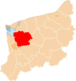
The county covers an area of 1,616.99 square kilometres (624.3 sq mi). As of 2006 its total population is 78,738, out of which the population of Goleniów is 22,448, that of
Nowogard is 16,745, that of Maszewo is 3,073, and the rural population is 36,472.
856:
682:
730:
86:
569:
609:
448:
166:
675:
539:
668:
624:
45:
60:
562:
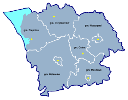
365:(three urban-rural and three rural). These are listed in the following table, in descending order of population.
290:
695:
286:
131:
851:
555:
525:
249:
126:
795:
72:
660:
644:
469:
181:
8:
780:
745:
825:
820:
604:
406:
161:
750:
720:
346:
810:
775:
322:
289:, north-western Poland. It came into being on January 1, 1999, as a result of the
815:
785:
350:
334:
274:
830:
790:
330:
805:
770:
765:
755:
649:
614:
490:
427:
326:
186:
171:
483:
845:
800:
342:
101:
88:
297:, which lies 22 kilometres (14 mi) north-east of the regional capital
639:
511:
176:
590:
420:
294:
141:
367:
231:
715:
709:
504:
441:
338:
302:
298:
262:
547:
462:
306:
281:) is a unit of territorial administration and local government (
691:
282:
33:
362:
148:
305:, lying 24 km (15 mi) north-east of Goleniów, and
293:
passed in 1998. Its administrative seat and largest town is
690:
309:, 19 km (12 mi) south-east of Goleniów.
843:
676:
563:
16:County in West Pomeranian Voivodeship, Poland
857:Land counties of West Pomeranian Voivodeship
683:
669:
570:
556:
356:
204:1,616.99 km (624.32 sq mi)
316:
301:. The county also contains the towns of
540:Polish official population figures 2006
844:
664:
551:
577:
13:
361:The county is subdivided into six
14:
868:
729:
623:
263:http://www.powiat-goleniowski.pl
71:
59:
44:
321:Goleniów County is bordered by
291:Polish local government reforms
65:Location within the voivodeship
369:
1:
533:
345:to the west, and the city of
83:Coordinates (Goleniów):
7:
696:West Pomeranian Voivodeship
287:West Pomeranian Voivodeship
10:
873:
337:to the south, the city of
738:
727:
702:
632:
621:
597:
585:
258:
248:
240:
229:
221:
213:
208:
200:
195:
147:
137:
125:
117:
82:
70:
58:
40:
31:
21:
357:Administrative division
278:
225:49/km (130/sq mi)
353:) to the north-west.
317:Neighbouring counties
222: • Density
77:Division into gminas
341:to the south-west,
98: /
598:Urban-rural gminas
279:powiat goleniowski
241: • Rural
214: • Total
201: • Total
26:Powiat goleniowski
839:
838:
658:
657:
645:Gmina Przybiernów
531:
530:
470:Gmina Przybiernów
395:
386:
268:
267:
182:Gmina Przybiernów
102:53.550°N 14.817°E
864:
733:
685:
678:
671:
662:
661:
627:
572:
565:
558:
549:
548:
393:
384:
368:
113:
112:
110:
109:
108:
103:
99:
96:
95:
94:
91:
75:
63:
48:
19:
18:
872:
871:
867:
866:
865:
863:
862:
861:
852:Goleniów County
842:
841:
840:
835:
734:
725:
698:
689:
659:
654:
628:
619:
593:
581:
579:Goleniów County
576:
545:
536:
392:
383:
359:
351:Szczecin Lagoon
335:Stargard County
319:
271:Goleniów County
191:
158:
157:
132:West Pomeranian
106:
104:
100:
97:
92:
89:
87:
85:
84:
78:
66:
54:
53:
52:
51:
36:
27:
24:
23:Goleniów County
17:
12:
11:
5:
870:
860:
859:
854:
837:
836:
834:
833:
828:
823:
818:
813:
808:
803:
798:
793:
788:
783:
778:
773:
768:
763:
758:
753:
748:
742:
740:
736:
735:
728:
726:
724:
723:
718:
713:
706:
704:
700:
699:
688:
687:
680:
673:
665:
656:
655:
653:
652:
650:Gmina Stepnica
647:
642:
636:
634:
630:
629:
622:
620:
618:
617:
615:Gmina Nowogard
612:
607:
605:Gmina Goleniów
601:
599:
595:
594:
586:
583:
582:
575:
574:
567:
560:
552:
543:
542:
535:
532:
529:
528:
523:
520:
517:
514:
508:
507:
502:
499:
496:
493:
491:Gmina Stepnica
487:
486:
481:
478:
475:
472:
466:
465:
460:
457:
454:
451:
445:
444:
439:
436:
433:
430:
428:Gmina Nowogard
424:
423:
418:
415:
412:
409:
407:Gmina Goleniów
403:
402:
397:
388:
379:
374:
358:
355:
329:to the north,
327:Gryfice County
318:
315:
266:
265:
260:
256:
255:
252:
246:
245:
242:
238:
237:
234:
227:
226:
223:
219:
218:
215:
211:
210:
206:
205:
202:
198:
197:
193:
192:
190:
189:
187:Gmina Stepnica
184:
179:
174:
172:Gmina Nowogard
169:
164:
162:Gmina Goleniów
155:
154:
153:
151:
145:
144:
139:
135:
134:
129:
123:
122:
119:
115:
114:
107:53.550; 14.817
80:
79:
76:
68:
67:
64:
56:
55:
49:
43:
42:
41:
38:
37:
32:
29:
28:
25:
22:
15:
9:
6:
4:
3:
2:
869:
858:
855:
853:
850:
849:
847:
832:
829:
827:
824:
822:
819:
817:
814:
812:
809:
807:
804:
802:
799:
797:
794:
792:
789:
787:
784:
782:
779:
777:
774:
772:
769:
767:
764:
762:
759:
757:
754:
752:
749:
747:
744:
743:
741:
739:Land counties
737:
732:
722:
719:
717:
714:
711:
708:
707:
705:
703:City counties
701:
697:
693:
686:
681:
679:
674:
672:
667:
666:
663:
651:
648:
646:
643:
641:
638:
637:
635:
631:
626:
616:
613:
611:
610:Gmina Maszewo
608:
606:
603:
602:
600:
596:
592:
589:
584:
580:
573:
568:
566:
561:
559:
554:
553:
550:
546:
541:
538:
537:
527:
524:
521:
518:
515:
513:
510:
509:
506:
503:
500:
497:
494:
492:
489:
488:
485:
482:
479:
476:
473:
471:
468:
467:
464:
461:
458:
455:
452:
450:
449:Gmina Maszewo
447:
446:
443:
440:
437:
434:
431:
429:
426:
425:
422:
419:
416:
413:
410:
408:
405:
404:
401:
398:
396:
389:
387:
380:
378:
375:
373:
370:
366:
364:
354:
352:
348:
344:
343:Police County
340:
336:
333:to the east,
332:
328:
324:
323:Kamień County
314:
310:
308:
304:
300:
296:
292:
288:
284:
280:
276:
272:
264:
261:
257:
253:
251:
247:
243:
239:
235:
233:
230: •
228:
224:
220:
216:
212:
207:
203:
199:
194:
188:
185:
183:
180:
178:
175:
173:
170:
168:
167:Gmina Maszewo
165:
163:
160:
159:
152:
150:
146:
143:
140:
136:
133:
130:
128:
124:
120:
116:
111:
81:
74:
69:
62:
57:
47:
39:
35:
30:
20:
760:
633:Rural gminas
587:
578:
544:
453:urban-rural
432:urban-rural
411:urban-rural
399:
390:
381:
376:
371:
360:
349:(across the
331:Łobez County
320:
311:
270:
269:
50:Coat of arms
721:Świnoujście
640:Gmina Osina
512:Gmina Osina
484:Przybiernów
347:Świnoujście
177:Gmina Osina
127:Voivodeship
105: /
846:Categories
826:Szczecinek
534:References
391:Population
250:Car plates
209:Population
796:Myślibórz
781:Kołobrzeg
751:Choszczno
746:Białogard
712:(capital)
816:Stargard
786:Koszalin
761:Goleniów
716:Koszalin
710:Szczecin
692:Counties
591:Goleniów
505:Stepnica
442:Nowogard
421:Goleniów
339:Szczecin
303:Nowogard
299:Szczecin
295:Goleniów
142:Goleniów
821:Świdwin
806:Pyrzyce
771:Gryfino
766:Gryfice
756:Drawsko
463:Maszewo
438:24,510
417:33,137
307:Maszewo
259:Website
156:Total 6
118:Country
93:14°49′E
90:53°33′N
811:Sławno
801:Police
776:Kamień
522:2,892
519:101.9
516:rural
501:4,693
498:294.2
495:rural
480:5,194
477:228.7
474:rural
459:8,312
456:210.5
435:338.7
414:443.1
394:(2006)
363:gminas
283:powiat
275:Polish
244:36,472
236:42,266
217:78,738
149:Gminas
121:Poland
34:County
831:Wałcz
791:Łobez
588:Seat:
526:Osina
372:Gmina
285:) in
232:Urban
400:Seat
385:(km)
382:Area
377:Type
325:and
196:Area
138:Seat
694:of
254:ZGL
848::
277::
684:e
677:t
670:v
571:e
564:t
557:v
273:(
Text is available under the Creative Commons Attribution-ShareAlike License. Additional terms may apply.


