29:
45:
445:
52:
197:. However, in actuality, the airstrip is generally located on the boundary or just north of the line, but the park service tends to overlook this fact. It also serves as the base camp for climbers attempting routes on the west or north sides of the formidable Mount Hunter, which rises just south of the Southeast Fork, and on the east or southeast sides of Mount Foraker, which lies just across the main part of the glacier.
193:
routes. The East Fork is rarely visited, but provides access to the west side of the South
Buttress of Denali. The mouth of the Southeast Fork is the site of the seasonal airstrip and base camp for Denali at approximately the 7,000 foot elevation. This location is officially just outside the southern boundary of the wilderness portion of
192:
The glacier has a few notable forks. The
Northeast Fork lies just under, and to the south of, the large plateau which houses the 14,000-foot (4,300 m) camp on the standard West Buttress route of Denali. It also provides access to the less popular, but more technical, West Rib and Cassin Ridge
200:
Many other unnamed forks split off to the east from the main stream of the glacier in the region south of Mount Hunter, providing access to a complex of small but steep rock peaks, popular with climbers, known as
275:
524:
514:
208:
100:
207:. The snout of the glacier lies further to the south, at elevation approximately 1,000 ft (300 m), where the glacier gives rise to the
169:
490:
509:
180:
to the east. The name was first reported as "Car-ilt-nu
Glacier" by Alaska Range explorer Lt. J.S. Herron in 1902. An alternate name is
359:
44:
329:
350:
426:
483:
262:
248:
194:
85:
430:
355:
203:
345:
534:
240:
476:
93:
529:
28:
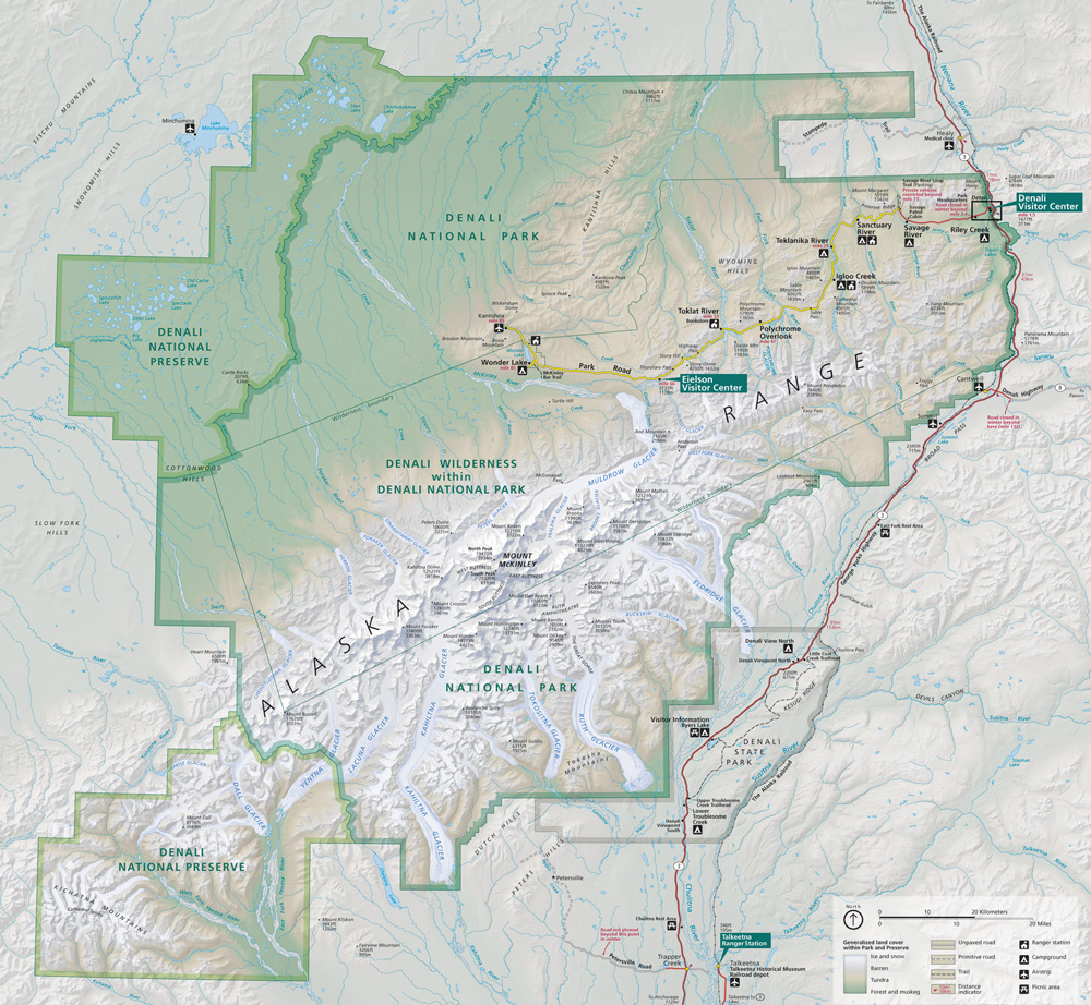
184:. Kahiltna Glacier is the longest glacier in the Alaska Range at 44 miles (71 km) in length.
268:
295:
81:
177:
464:
172:(elevation 10,320 ft (3,150 m)). Its main channel runs almost due south between
8:
412:
379:
325:
258:
244:
220:
417:
519:
421:
460:
503:
408:
173:
115:
102:
153:
444:
232:
157:
452:
149:
456:
165:
161:
324:(Map). !:225,000. National Geographic Maps. 2007.
501:
525:Glaciers of Denali National Park and Preserve
515:Glaciers of Matanuska-Susitna Borough, Alaska
484:
290:
288:
286:
491:
477:
296:"Map of Denali National Park and Preserve"
283:
237:Mount McKinley: Icy Crown of North America
360:United States Department of the Interior
51:
372:
502:
164:. It starts on the southwest slope of
439:
257:, American Alpine Club Press, 1989,
418:1990 photograph of Kahiltna Glacier
409:1964 photograph of Kahiltna Glacier
351:Geographic Names Information System
338:
13:
510:Glaciers of Denali Borough, Alaska
14:
546:
402:
384:Denali National Park and Preserve
322:Denali National Park and Preserve
300:Denali National Park and Preserve
195:Denali National Park and Preserve
86:Matanuska-Susitna Borough, Alaska
443:
50:
43:
27:
16:Glacier in Alaska, United States
431:United States Geological Survey
356:United States Geological Survey
427:Photograph of Kahiltna Glacier
314:
1:
226:
33:Kahiltna Glacier to the right
463:. You can help Knowledge by
276:Kahiltna Glacier on Topozone
7:
214:
10:
551:
438:
139:
131:
92:
77:
69:
38:
26:
21:
187:
386:. National Park Service
302:. National Park Service
269:American Alpine Journal
116:62.76583°N 151.30333°W
82:Denali Borough, Alaska
451:This article about a
135:44 miles (71 km)
535:Alaska glacier stubs
121:62.76583; -151.30333
253:Jonathan Waterman,
112: /
530:Glaciers of Alaska
346:"Kahiltna Glacier"
241:Mountaineers Books
204:Little Switzerland
472:
471:
413:Bradford Washburn
331:978-1-56695-328-3
143:
142:
542:
493:
486:
479:
447:
440:
396:
395:
393:
391:
376:
370:
369:
367:
366:
342:
336:
335:
318:
312:
311:
309:
307:
292:
221:List of glaciers
176:to the west and
146:Kahiltna Glacier
127:
126:
124:
123:
122:
117:
113:
110:
109:
108:
105:
58:Kahiltna Glacier
54:
53:
47:
31:
22:Kahiltna Glacier
19:
18:
550:
549:
545:
544:
543:
541:
540:
539:
500:
499:
498:
497:
436:
422:Marilyn Bridges
405:
400:
399:
389:
387:
378:
377:
373:
364:
362:
344:
343:
339:
332:
320:
319:
315:
305:
303:
294:
293:
284:
229:
217:
190:
148:is the longest
120:
118:
114:
111:
106:
103:
101:
99:
98:
65:
64:
63:
62:
61:
60:
59:
55:
34:
17:
12:
11:
5:
548:
538:
537:
532:
527:
522:
517:
512:
496:
495:
488:
481:
473:
470:
469:
448:
434:
433:
424:
415:
404:
403:External links
401:
398:
397:
371:
337:
330:
313:
281:
280:
279:
278:
273:
265:
251:
228:
225:
224:
223:
216:
213:
209:Kahiltna River
189:
186:
182:Kagheltnu Li'a
141:
140:
137:
136:
133:
129:
128:
96:
90:
89:
79:
75:
74:
73:Valley glacier
71:
67:
66:
57:
56:
49:
48:
42:
41:
40:
39:
36:
35:
32:
24:
23:
15:
9:
6:
4:
3:
2:
547:
536:
533:
531:
528:
526:
523:
521:
518:
516:
513:
511:
508:
507:
505:
494:
489:
487:
482:
480:
475:
474:
468:
466:
462:
458:
454:
449:
446:
442:
441:
437:
432:
428:
425:
423:
419:
416:
414:
410:
407:
406:
385:
381:
375:
361:
357:
353:
352:
347:
341:
333:
327:
323:
317:
301:
297:
291:
289:
287:
282:
277:
274:
271:
270:
266:
264:
263:0-930410-41-6
260:
256:
252:
250:
249:0-89886-646-4
246:
242:
238:
234:
231:
230:
222:
219:
218:
212:
210:
206:
205:
198:
196:
185:
183:
179:
175:
174:Mount Foraker
171:
170:Kahiltna Pass
167:
163:
159:
155:
151:
147:
138:
134:
130:
125:
97:
95:
91:
87:
83:
80:
76:
72:
68:
46:
37:
30:
25:
20:
465:expanding it
450:
435:
388:. Retrieved
383:
374:
363:. Retrieved
349:
340:
321:
316:
304:. Retrieved
299:
267:
254:
236:
202:
199:
191:
181:
178:Mount Hunter
154:Alaska Range
145:
144:
255:High Alaska
233:Fred Beckey
119: /
107:151°18′12″W
94:Coordinates
504:Categories
380:"Glaciers"
365:2013-03-29
227:References
158:U.S. state
104:62°45′57″N
429:from the
390:29 March
306:25 March
243:, 1999,
215:See also
78:Location
453:glacier
156:in the
152:of the
150:glacier
520:Denali
457:Alaska
328:
272:, 2001
261:
247:
166:Denali
162:Alaska
132:Length
88:, U.S.
459:is a
188:Forks
168:near
461:stub
392:2013
326:ISBN
308:2013
259:ISBN
245:ISBN
84:and
70:Type
455:in
420:by
411:by
160:of
506::
382:.
358:,
354:.
348:.
298:.
285:^
239:,
235:,
211:.
492:e
485:t
478:v
467:.
394:.
368:.
334:.
310:.
Text is available under the Creative Commons Attribution-ShareAlike License. Additional terms may apply.
_-_NARA_-_23933579.jpg)
