512:
270:
20:
217:
193:
258:
236:
251:
577:
473:
553:
244:
266:
19:
582:
546:
572:
156:
539:
105:
228:
391:
290:
333:
35:
527:
81:
63:
46:. The district covers an area of 4,259 km² and has a population of 395,897. The word
8:
414:
318:
278:
31:
449:
424:
419:
409:
404:
356:
274:
429:
376:
361:
351:
303:
298:
454:
444:
434:
399:
381:
371:
323:
313:
308:
123:
523:
459:
341:
87:
566:
488:
475:
439:
346:
135:
117:
141:
129:
99:
93:
75:
67:
111:
47:
43:
511:
51:
229:
Parliament of Malawi - Members of
Parliament - Nkhotakota District
519:
282:
269:
66:, the distribution of the population of Nkhotakota District by
39:
150:
218:
2018 Malawi
Population and Housing Census Main Report
564:
194:"2018 Population and Housing Census Main Report"
54:. It is located along the shore of Lake Malawi.
547:
252:
554:
540:
259:
245:
186:
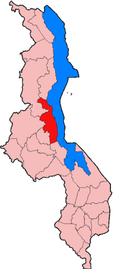
23:Location of Nkhotakota District in Malawi
151:Government and administrative divisions
565:
240:
506:
199:. Malawi National Statistical Office
578:Districts in Central Region, Malawi
13:
18:
14:
594:
510:
268:
57:
222:
211:
159:constituencies in Nkhotakota:
1:
179:
526:. You can help Knowledge by
7:
10:
599:
505:
390:
332:
289:
175:Nkhotakota - South East
169:Nkhotakota - North East
583:Malawi geography stubs
522:location article is a
24:
64:2018 Census of Malawi
22:
163:Nkhotakota - Central
573:Districts of Malawi
485: /
62:At the time of the
50:means "zig-zag" in
172:Nkhotakota - South
166:Nkhotakota - North
25:
16:District of Malawi
535:
534:
489:13.000°S 34.083°E
468:
467:
157:National Assembly
42:. The capital is
590:
556:
549:
542:
514:
507:
500:
499:
497:
496:
495:
490:
486:
483:
482:
481:
478:
273:
272:
261:
254:
247:
238:
237:
231:
226:
220:
215:
209:
208:
206:
204:
198:
190:
70:was as follows:
598:
597:
593:
592:
591:
589:
588:
587:
563:
562:
561:
560:
503:
494:-13.000; 34.083
493:
491:
487:
484:
479:
476:
474:
472:
471:
469:
464:
392:Southern Region
386:
328:
291:Northern Region
285:
267:
265:
235:
234:
227:
223:
216:
212:
202:
200:
196:
192:
191:
187:
182:
155:There are five
153:
60:
17:
12:
11:
5:
596:
586:
585:
580:
575:
559:
558:
551:
544:
536:
533:
532:
515:
466:
465:
463:
462:
457:
452:
447:
442:
437:
432:
427:
422:
417:
412:
407:
402:
396:
394:
388:
387:
385:
384:
379:
374:
369:
364:
359:
354:
349:
344:
338:
336:
334:Central Region
330:
329:
327:
326:
321:
316:
311:
306:
301:
295:
293:
287:
286:
264:
263:
256:
249:
241:
233:
232:
221:
210:
184:
183:
181:
178:
177:
176:
173:
170:
167:
164:
152:
149:
148:
147:
144:
138:
132:
126:
120:
114:
108:
102:
96:
90:
84:
78:
59:
56:
36:Central Region
15:
9:
6:
4:
3:
2:
595:
584:
581:
579:
576:
574:
571:
570:
568:
557:
552:
550:
545:
543:
538:
537:
531:
529:
525:
521:
516:
513:
509:
508:
504:
501:
498:
461:
458:
456:
453:
451:
448:
446:
443:
441:
438:
436:
433:
431:
428:
426:
423:
421:
418:
416:
413:
411:
408:
406:
403:
401:
398:
397:
395:
393:
389:
383:
380:
378:
375:
373:
370:
368:
365:
363:
360:
358:
355:
353:
350:
348:
345:
343:
340:
339:
337:
335:
331:
325:
322:
320:
317:
315:
312:
310:
307:
305:
302:
300:
297:
296:
294:
292:
288:
284:
280:
276:
271:
262:
257:
255:
250:
248:
243:
242:
239:
230:
225:
219:
214:
195:
189:
185:
174:
171:
168:
165:
162:
161:
160:
158:
145:
143:
139:
137:
133:
131:
127:
125:
121:
119:
115:
113:
109:
107:
103:
101:
97:
95:
91:
89:
85:
83:
79:
77:
73:
72:
71:
69:
65:
55:
53:
49:
45:
41:
37:
33:
29:
21:
528:expanding it
517:
502:
470:
366:
224:
213:
201:. Retrieved
188:
154:
68:ethnic group
61:
58:Demographics
27:
26:
492: /
203:25 December
146:0.2% Others
567:Categories
415:Chiradzulu
367:Nkhotakota
319:Nkhata Bay
180:References
48:Nkhotakota
44:Nkhotakota
28:Nkhotakota
279:districts
130:Mang'anja
450:Phalombe
425:Mangochi
420:Machinga
410:Chikwawa
405:Blantyre
357:Lilongwe
52:Chichewa
32:district
480:34°05′E
477:13°00′S
430:Mulanje
377:Ntchisi
362:Mchinji
352:Kasungu
304:Karonga
299:Chitipa
275:Regions
124:Nkhonde
88:Tumbuka
34:in the
520:Malawi
455:Thyolo
445:Nsanje
435:Mwanza
400:Balaka
382:Salima
372:Ntcheu
324:Rumphi
314:Mzimba
309:Likoma
283:Malawi
136:Lambya
118:Nyanja
80:10.4%
74:75.8%
40:Malawi
518:This
460:Zomba
342:Dedza
197:(PDF)
142:Sukwa
140:0.1%
134:0.2%
128:0.4%
122:0.4%
116:0.5%
110:1.7%
104:1.9%
100:Ngoni
98:2.3%
94:Lomwe
92:2.1%
86:3.9%
82:Tonga
76:Chewa
30:is a
524:stub
440:Neno
347:Dowa
277:and
205:2019
112:Sena
281:of
106:Yao
38:of
569::
555:e
548:t
541:v
530:.
260:e
253:t
246:v
207:.
Text is available under the Creative Commons Attribution-ShareAlike License. Additional terms may apply.
