132:
231:
142:
120:
100:
305:
104:
295:
276:
50:. It is located in the center-northwest of the province, bordered by the Sierras Chicas in the east and the Sierras Grandes and the
72:, is located on the southern shore of San Roque lake, though the valley is known for a number of other scenic towns, including
269:
195:
43:
262:
238:
300:
89:
131:
107:
were completed within the valley in 1943 and 1979, respectively, to address the area's water and
39:
81:
230:
85:
8:
250:
162:
57:
in the west, oriented from north to south. In the southern part of the valley lies the
180:
77:
69:
24:
62:
54:
246:
58:
111:
needs, and have since become important recreational areas in their own right.
289:
210:
197:
108:
141:
73:
93:
242:
47:
123:
174:
32:
186:
119:
51:
35:
68:
The most important tourist location in Córdoba, the city of
287:
61:, fed mainly by the San Antonio River and the
270:
189:- Todo el Valle de Punilla en un solo Sitio.
306:Córdoba Province, Argentina geography stubs
277:
263:
296:Landforms of Córdoba Province, Argentina
140:
130:
118:
288:
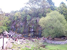
145:The Seven Falls Springs, near La Falda
225:
135:Yacoana Springs, San Francisco River
16:Fluvial valley in Córdoba, Argentina
13:
14:
317:
229:
175:Bienvenidos al Valle de Punilla
237:This article about a place in
1:
168:
249:. You can help Knowledge by
7:
156:
10:
322:
224:
149:
139:
129:
117:
146:
136:
126:
28:
144:
134:
122:
301:Valleys of Argentina
207: /
183:- Valle de Punilla.
177:- Valle de Punilla.
105:La Falda Reservoirs
163:Punilla Department
147:
137:
127:
258:
257:
211:31.033°S 64.500°W
153:
152:
78:Capilla del Monte
313:
279:
272:
265:
239:Córdoba Province
233:
226:
222:
221:
219:
218:
217:
216:-31.033; -64.500
212:
208:
205:
204:
203:
200:
115:
114:
70:Villa Carlos Paz
29:Valle de Punilla
321:
320:
316:
315:
314:
312:
311:
310:
286:
285:
284:
283:
215:
213:
209:
206:
201:
198:
196:
194:
193:
171:
159:
154:
17:
12:
11:
5:
319:
309:
308:
303:
298:
282:
281:
274:
267:
259:
256:
255:
234:
191:
190:
187:Punilla Online
184:
181:Córdoba Global
178:
170:
167:
166:
165:
158:
155:
151:
150:
148:
138:
128:
113:
59:San Roque Lake
21:Punilla Valley
15:
9:
6:
4:
3:
2:
318:
307:
304:
302:
299:
297:
294:
293:
291:
280:
275:
273:
268:
266:
261:
260:
254:
252:
248:
244:
240:
235:
232:
228:
227:
223:
220:
188:
185:
182:
179:
176:
173:
172:
164:
161:
160:
143:
133:
125:
124:Mount Uritoco
121:
116:
112:
110:
109:flood control
106:
102:
97:
95:
91:
90:Valle Hermoso
87:
83:
79:
75:
71:
66:
64:
63:Cosquín River
60:
56:
53:
49:
45:
41:
37:
34:
31:) is a broad
30:
26:
22:
251:expanding it
236:
192:
101:Cruz del Eje
98:
74:Cruz del Eje
67:
20:
18:
214: /
290:Categories
169:References
243:Argentina
82:La Cumbre
48:Argentina
157:See also
86:La Falda
40:province
202:64°30′W
199:31°02′S
94:Cosquín
44:Córdoba
38:in the
33:fluvial
25:Spanish
92:, and
55:Achala
36:valley
245:is a
52:Pampa
247:stub
103:and
99:The
19:The
42:of
292::
241:,
96:.
88:,
84:,
80:,
76:,
65:.
46:,
27::
278:e
271:t
264:v
253:.
23:(
Text is available under the Creative Commons Attribution-ShareAlike License. Additional terms may apply.


