105:
350:
978:
779:
769:
92:
1024:
70:
60:
759:
45:
927:
112:
859:
459:) characterized by warm summers and cool winters with light snowfall. The average annual temperature in Tobe is 14.3 °C. The average annual rainfall is 1777 mm with September as the wettest month. The temperatures are highest on average in January, at around 25.4 °C, and lowest in January, at around 3.2 °C.
823:
841:
407:
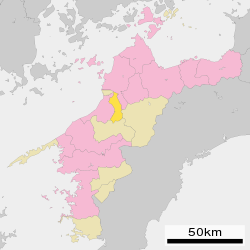
Tobe is almost in the center of Ehime
Prefecture, across the Shigenobu River south of Matsuyama City. There are many mountains in the south, and the northern portion of the town occupies the southern tip of the Matsuyama Plain. The entire Tobe area is located on gentle hills.
863:
828:
825:
860:
824:
846:
843:
842:
862:
827:
661:. The village of Tobe was established with the creation of the modern municipalities system in 1889. It was raised to town status in 1928 and annexed the neighboring village of Haramachi in 1955. On January 1, 2005, the village of
706:
ceramics, and there are more than 80 kilns in the town. Agriculture, notably citrus cultivation and light manufacturing (food processing and electrical components) are mainstays of the local economy. The town is also increasing a
845:
685:
town council of 16 members. Tobe, together with the town of
Matsumae, contributes two members to the Ehime Prefectural Assembly. In terms of national politics, the town is part of Ehime 2nd district of the
719:
Tobe has four public elementary schools and one public middle school operated by the town government, and one public high school operated by the Ehime
Prefectural Board of Education. The
861:
826:
844:
720:
104:
136:
977:
467:
Per
Japanese census data, the population of Tobe peaked around the year 2000 and has declined slightly in the decades since.
1199:
1218:
945:
687:
967:
1023:
931:
399:
of 200 persons per km. The total area of the town is 101.59 square kilometres (39.22 sq mi).
91:
900:
69:
1157:
1145:
995:
452:
1133:
782:
176:
1116:
887:
772:
376:
745:
1223:
1181:
1169:
1005:
762:
741:
188:
59:
8:
1099:
960:
807:
666:
380:
255:
205:
1150:
440:
349:
44:
975:
396:
200:
911:
1068:
981:
650:
642:
420:
384:
193:
1174:
1058:
1126:
1078:
1038:
953:
35:
1073:
1212:
1186:
1121:
1104:
708:
691:
678:
662:
634:
435:
430:
151:
138:
1053:
654:
1162:
1063:
658:
638:
623:
619:
320:
630:
1083:
1043:
682:
646:
425:
392:
251:
1013:
990:
703:
246:
737:
1048:
937:
181:
276:
926:
391:. As of 28 February 2022, the town had an estimated
1138:
736:
Tobe has no passenger rail service. The nearest stations are
626:
388:
301:
629:
within the city limits, and the name of Tobe appears in
681:
form of government with a directly elected mayor and a
266:
1392 Miyauchi, Tobe-chō, Iyo-gun, Ehime-ken 791-2195
1210:
633:records as an estate belonging to the temple of
368:
331:
721:Ehime Prefectural University of Health Science
362:
325:
306:
961:
411:
968:
954:
801:
348:
649:, the area was part of the holdings of
1211:
880:
484:
220:101.59 km (39.22 sq mi)
949:
702:Tobe is famous for the production of
618:The area of Tobe was part of ancient
788:
84:Location of Tobe in Ehime Prefecture
1200:List of mergers in Ehime Prefecture
395:of 20,485 in 9385 households and a
13:
479:
14:
1235:
919:
726:
1022:
976:
925:
857:
839:
821:
777:
767:
757:
110:
103:
90:
68:
58:
43:
888:"Tobe town official statistics"
797:Ehime Prefectural Sports Compex
637:. The area was famous from the
462:
905:
894:
641:onwards for its production of
1:
874:
672:
714:
402:
111:
7:
711:for neighboring Matsuyama.
369:
332:
10:
1240:
912:Tobe population statistics
814:
751:
731:
697:
613:
446:
412:Surrounding municipalities
1219:Towns in Ehime Prefecture
1197:
1092:
1031:
1020:
1004:
988:
497:—
453:humid subtropical climate
363:
343:
326:
316:
307:
297:
293:
288:
284:
270:
262:
245:
237:
229:
224:
216:
211:
199:
187:
175:
167:
132:
98:
89:
82:
54:
42:
33:
21:
723:is located in the town.
669:, was merged into Tobe.
622:. There are a number of
353:example of Tobe ceramics
25:
810:, stage actor, director
783:National Route 379
241:200/km (520/sq mi)
802:Noted people from Tobe
773:National Route 33
653:and was later part of
354:
16:Town in Shikoku, Japan
938:Tobe official website
890:(in Japanese). Japan.
746:Iyo-Tachibana Station
471:Historical population
352:
934:at Wikimedia Commons
794:Tobe Zoological Park
763:Matsuyama Expressway
742:Matsuyamashi Station
238: • Density
657:and its subsidiary
472:
148: /
1158:Minamiuwa District
1146:Kamiukena District
470:
397:population density
355:
230: • Total
217: • Total
152:33.750°N 132.800°E
1206:
1205:
1134:Nishiuwa District
999:
930:Media related to
901:Tobe climate data
869:Tobe Thrust Fault
864:
847:
829:
789:Local attractions
611:
610:
416:Ehime Prefecture
347:
346:
263:City hall address
124:Location in Japan
1231:
1117:Kitauwa District
1026:
993:
982:Ehime Prefecture
980:
970:
963:
956:
947:
946:
942:
929:
914:
909:
903:
898:
892:
891:
884:
866:
865:
849:
848:
831:
830:
781:
780:
771:
770:
761:
760:
651:Matsuyama Domain
486:
481:
473:
469:
385:Ehime Prefecture
374:
372:
366:
365:
339:
338:
335:
329:
328:
312:
310:
309:
280:
279:
277:Official website
163:
162:
160:
159:
158:
153:
149:
146:
145:
144:
141:
114:
113:
107:
94:
72:
62:
47:
28:
19:
18:
1239:
1238:
1234:
1233:
1232:
1230:
1229:
1228:
1209:
1208:
1207:
1202:
1193:
1088:
1027:
1018:
1000:
984:
974:
940:
922:
917:
910:
906:
899:
895:
886:
885:
881:
877:
870:
867:
858:
853:
850:
840:
835:
834:Konpirasan Park
832:
822:
817:
804:
791:
778:
768:
758:
754:
734:
729:
717:
700:
675:
616:
465:
449:
414:
405:
360:
336:
323:
304:
275:
274:
157:33.750; 132.800
156:
154:
150:
147:
142:
139:
137:
135:
134:
128:
127:
126:
125:
122:
121:
120:
119:
115:
85:
78:
77:
76:
75:
66:
65:
50:
38:
29:
26:
24:
17:
12:
11:
5:
1237:
1227:
1226:
1221:
1204:
1203:
1198:
1195:
1194:
1192:
1191:
1190:
1189:
1179:
1178:
1177:
1167:
1166:
1165:
1155:
1154:
1153:
1143:
1142:
1141:
1131:
1130:
1129:
1124:
1114:
1113:
1112:
1107:
1096:
1094:
1090:
1089:
1087:
1086:
1081:
1076:
1071:
1066:
1061:
1056:
1051:
1046:
1041:
1035:
1033:
1029:
1028:
1021:
1019:
1017:
1016:
1010:
1008:
1002:
1001:
989:
986:
985:
973:
972:
965:
958:
950:
944:
943:
935:
921:
920:External links
918:
916:
915:
904:
893:
878:
876:
873:
872:
871:
868:
856:
854:
852:Rishoin Temple
851:
838:
836:
833:
820:
816:
813:
812:
811:
803:
800:
799:
798:
795:
790:
787:
786:
785:
775:
765:
753:
750:
733:
730:
728:
727:Transportation
725:
716:
713:
699:
696:
674:
671:
615:
612:
609:
608:
605:
602:
598:
597:
594:
591:
587:
586:
583:
580:
576:
575:
572:
569:
565:
564:
561:
558:
554:
553:
550:
547:
543:
542:
539:
536:
532:
531:
528:
525:
521:
520:
517:
514:
510:
509:
506:
503:
499:
498:
495:
492:
488:
487:
482:
477:
464:
461:
448:
445:
444:
443:
438:
433:
428:
423:
413:
410:
404:
401:
345:
344:
341:
340:
318:
314:
313:
299:
295:
294:
291:
290:
286:
285:
282:
281:
272:
268:
267:
264:
260:
259:
249:
243:
242:
239:
235:
234:
231:
227:
226:
222:
221:
218:
214:
213:
209:
208:
203:
197:
196:
191:
185:
184:
179:
173:
172:
169:
165:
164:
130:
129:
123:
117:
116:
109:
108:
102:
101:
100:
99:
96:
95:
87:
86:
83:
80:
79:
73:
67:
63:
57:
56:
55:
52:
51:
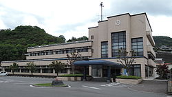
49:Tobe Town Hall
48:
40:
39:
34:
31:
30:
22:
15:
9:
6:
4:
3:
2:
1236:
1225:
1222:
1220:
1217:
1216:
1214:
1201:
1196:
1188:
1185:
1184:
1183:
1182:Kita District
1180:
1176:
1173:
1172:
1171:
1170:Ochi District
1168:
1164:
1161:
1160:
1159:
1156:
1152:
1149:
1148:
1147:
1144:
1140:
1137:
1136:
1135:
1132:
1128:
1125:
1123:
1120:
1119:
1118:
1115:
1111:
1108:
1106:
1103:
1102:
1101:
1098:
1097:
1095:
1091:
1085:
1082:
1080:
1077:
1075:
1072:
1070:
1067:
1065:
1062:
1060:
1057:
1055:
1052:
1050:
1047:
1045:
1042:
1040:
1037:
1036:
1034:
1030:
1025:
1015:
1012:
1011:
1009:
1007:
1003:
997:
992:
987:
983:
979:
971:
966:
964:
959:
957:
952:
951:
948:
941:(in Japanese)
939:
936:
933:
928:
924:
923:
913:
908:
902:
897:
889:
883:
879:
855:
837:
819:
818:
809:
806:
805:
796:
793:
792:
784:
776:
774:
766:
764:
756:
755:
749:
747:
743:
739:
724:
722:
712:
710:
709:commuter town
705:
695:
693:
692:Diet of Japan
689:
684:
680:
679:mayor-council
670:
668:
664:
660:
656:
652:
648:
645:. During the
644:
640:
636:
632:
628:
627:burial mounds
625:
621:
606:
603:
600:
599:
595:
592:
589:
588:
584:
581:
578:
577:
573:
570:
567:
566:
562:
559:
556:
555:
551:
548:
545:
544:
540:
537:
534:
533:
529:
526:
523:
522:
518:
515:
512:
511:
507:
504:
501:
500:
496:
493:
490:
489:
483:
478:
475:
474:
468:
460:
458:
454:
442:
439:
437:
434:
432:
429:
427:
424:
422:
419:
418:
417:
409:
400:
398:
394:
390:
386:
382:
378:
371:
359:
351:
342:
334:
322:
319:
315:
303:
300:
296:
292:
287:
283:
278:
273:
269:
265:
261:
257:
253:
250:
248:
244:
240:
236:
232:
228:
223:
219:
215:
210:
207:
204:
202:
198:
195:
192:
190:
186:
183:
180:
178:
174:
170:
166:
161:
133:Coordinates:
131:
106:
97:
93:
88:
81:
71:
61:
53:
46:
41:
37:
32:
20:
1109:
1100:Iyo District
907:
896:
882:
735:
718:
701:
676:
667:Iyo District
665:, also from
659:Niiya Domain
639:Heian period
624:Kofun period
620:Iyo Province
617:
466:
463:Demographics
456:
450:
415:
406:
381:Iyo District
357:
356:
321:Sawtooth Oak
1224:Tobe, Ehime
1069:Shikokuchūō
932:Tobe, Ehime
808:Masao Inoue
688:lower house
677:Tobe has a
631:Nara period
451:Tobe has a
379:located in
155: /
1213:Categories
1084:Yawatahama
875:References
683:unicameral
673:Government
655:Ōzu Domain
647:Edo period
643:whetstones
393:population
225:Population
189:Prefecture
1151:Kumakōgen
1093:Districts
1014:Matsuyama
1006:Core city
991:Matsuyama
715:Education
704:Tobe ware
441:Kumakōgen
421:Matsuyama
403:Geography
252:UTC+09:00
247:Time zone
1175:Kamijima
738:Iyotetsu
635:Hōryū-ji
455:(Köppen
370:Tobe-chō
201:District
143:132°48′E
1127:Matsuno
1079:Uwajima
1049:Niihama
1039:Imabari
996:capital
815:Gallery
752:Highway
732:Railway
698:Economy
690:of the
614:History
447:Climate
289:Symbols
271:Website
182:Shikoku
168:Country
140:33°45′N
1187:Uchiko
1122:Kihoku
1105:Masaki
1032:Cities
663:Hirota
604:20,480
593:21,981
582:22,075
574:+15.8%
571:20,802
563:+29.8%
560:17,958
549:13,831
538:14,603
530:+31.8%
527:15,829
516:12,011
505:11,891
494:11,810
436:Uchiko
431:Masaki
333:Kunugi
298:Flower
233:20,485
177:Region
74:Emblem
1163:Ainan
1139:Ikata
1064:Seiyo
1059:Saijō
607:−6.8%
601:2020
596:−0.4%
590:2010
585:+6.1%
579:2000
568:1990
557:1980
552:−5.3%
546:1970
541:−7.7%
535:1960
524:1950
519:+1.0%
513:1940
508:+0.7%
502:1930
491:1920
389:Japan
375:is a
194:Ehime
171:Japan
1110:Tobe
1074:Tōon
480:Pop.
476:Year
377:town
358:Tobe
317:Tree
212:Area
118:Tobe
64:Flag
36:Town
23:Tobe
1054:Ōzu
1044:Iyo
744:or
740:'s
457:Cfa
426:Iyo
364:砥部町
302:Ume
256:JST
206:Iyo
27:砥部町
1215::
748:.
694:.
485:±%
387:,
383:,
367:,
330:,
998:)
994:(
969:e
962:t
955:v
373:)
361:(
337:)
327:櫟
324:(
311:)
308:梅
305:(
258:)
254:(
Text is available under the Creative Commons Attribution-ShareAlike License. Additional terms may apply.


