43:
76:
323:
410:
29:
83:
50:
267:
is 25 kilometres (16 mi) long and is surrounded by dozens of mountain peaks that are all more than 2,000 metres (6,600 ft) in height. From Øvre Årdal, a comfortable walking road has been constructed, funded by voluntary contributions. The road passes through the
287:
in 1980 and covers about 300 square kilometres (120 sq mi). It includes both the valley and areas that extend both westward and northward to
Jotunheim National Park, and eastward to lake
451:
191:
272:
farm area and crosses the Utla river on four spectacular bridges. The walking path ends at one of Norway's tallest waterfalls,
42:
280:
490:
444:
75:
485:
184:
319:
which means "drift" or "fly"—the many waterfalls of the river creates a mist in the bottom of the valley.
437:
344:
480:
392:
284:
269:
169:
233:
8:
249:
470:
475:
425:
264:
245:
177:
421:
279:
Since
Utladalen is considered to be unique in Norway and internationally, the
464:
206:
193:
140:
322:
273:
263:
Utladalen is Norway's deepest valley. The main valley, when measuring from
173:
393:
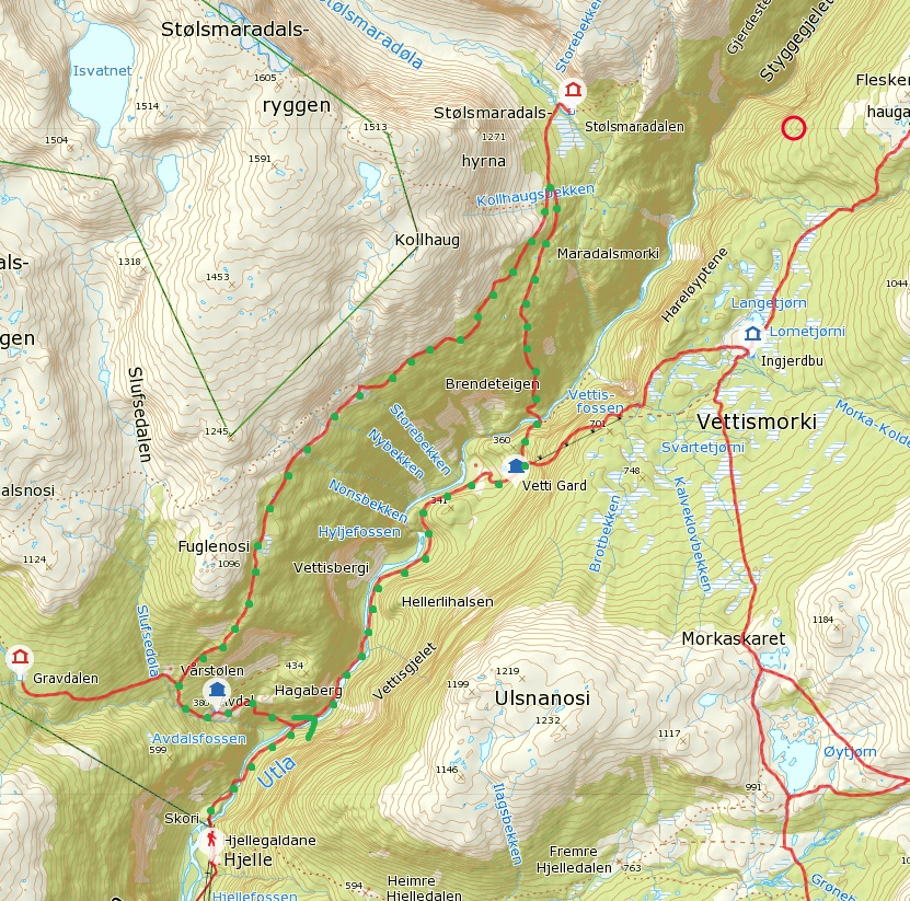
Map of
Jotunheimen National Park and Utladalen Landscape Protection Area
409:
28:
417:
257:
237:
155:
253:
312:
241:
159:
348:
368:
288:
326:
Avdalsfossen, one of the several waterfalls in the valley.
303:. The first element is the genitive of the river name
315:". The river name is probably derived from the verb
260:valleys branch off of the main Utladalen valley.
462:
445:
307:and the last element is the finite form of
452:
438:
244:. It stretches north from the village of
321:
283:was established along with the adjacent
463:
404:
281:Utladalen Landscape Protection Area
13:
14:
502:
386:
82:
49:
408:
81:
74:
48:
41:
27:
361:
337:
1:
371:(in Norwegian). Sognefjord.no
330:
299:The official form on maps is
424:. You can help Knowledge by
7:
10:
507:
403:
111:716 m (2,349 ft)
16:Valley in Vestland, Norway
183:
165:
151:
146:
136:
131:
127:2.5 km (1.6 mi)
123:
115:
107:
35:
26:
21:
491:Vestland geography stubs
311:which means "dale" or "
294:
285:Jotunheim National Park
119:25 km (16 mi)
420:location article is a
327:
62:Location of the valley
325:
248:into the neighboring
207:61.40000°N 7.97083°E
65:Show map of Vestland
486:Valleys of Vestland
250:Luster Municipality
203: /
328:
234:Årdal Municipality
166:Population centers
98:Show map of Norway
95:Utladalen (Norway)
433:
432:
232:) is a valley in
223:
222:
212:61.40000; 7.97083
498:
454:
447:
440:
412:
405:
397:
380:
379:
377:
376:
365:
359:
358:
356:
355:
347:(in Norwegian).
341:
218:
217:
215:
214:
213:
208:
204:
201:
200:
199:
196:
99:
85:
84:
78:
66:
52:
51:
45:
31:
19:
18:
506:
505:
501:
500:
499:
497:
496:
495:
461:
460:
459:
458:
401:
395:
389:
384:
383:
374:
372:
367:
366:
362:
353:
351:
343:
342:
338:
333:
297:
211:
209:
205:
202:
197:
194:
192:
190:
189:
108:Floor elevation
103:
102:
101:
100:
97:
96:
93:
92:
91:
90:
86:
69:
68:
67:
64:
63:
60:
59:
58:
57:
53:
17:
12:
11:
5:
504:
494:
493:
488:
483:
481:Luster, Norway
478:
473:
457:
456:
449:
442:
434:
431:
430:
413:
399:
398:
396:(in Norwegian)
388:
387:External links
385:
382:
381:
360:
335:
334:
332:
329:
296:
293:
221:
220:
187:
181:
180:
167:
163:
162:
153:
149:
148:
144:
143:
138:
134:
133:
129:
128:
125:
121:
120:
117:
113:
112:
109:
105:
104:
94:
88:
87:
80:
79:
73:
72:
71:
70:
61:
55:
54:
47:
46:
40:
39:
38:
37:
36:
33:
32:
24:
23:
15:
9:
6:
4:
3:
2:
503:
492:
489:
487:
484:
482:
479:
477:
474:
472:
469:
468:
466:
455:
450:
448:
443:
441:
436:
435:
429:
427:
423:
419:
414:
411:
407:
406:
402:
394:
391:
390:
370:
364:
350:
346:
340:
336:
324:
320:
318:
314:
310:
306:
302:
292:
290:
286:
282:
277:
275:
271:
266:
261:
259:
255:
251:
247:
243:
239:
235:
231:
227:
216:
188:
186:
182:
179:
175:
171:
168:
164:
161:
157:
154:
150:
145:
142:
139:
135:
130:
126:
122:
118:
114:
110:
106:
77:
44:
34:
30:
25:
20:
426:expanding it
415:
400:
373:. Retrieved
363:
352:. Retrieved
339:
316:
308:
304:
300:
298:
278:
274:Vettisfossen
262:
229:
225:
224:
141:River valley
369:"Utladalen"
345:"Utladalen"
210: /
185:Coordinates
174:Vettismorki
465:Categories
375:2010-09-06
354:2010-09-06
331:References
265:Øvre Årdal
246:Øvre Årdal
198:07°58′15″E
195:61°24′00″N
178:Øvre Årdal
471:Utladalen
301:Utledalen
226:Utladalen
147:Geography
89:Utladalen
56:Utladalen
22:Utladalen
418:Vestland
258:Fardalen
240:county,
238:Vestland
156:Vestland
152:Location
254:Avdalen
230:Utladal
219:
132:Geology
313:valley
252:. The
242:Norway
160:Norway
116:Length
476:Årdal
416:This
349:yr.no
270:Vetti
170:Vetti
124:Width
422:stub
317:utle
305:Utla
295:Name
289:Tyin
256:and
228:(or
137:Type
309:dal
236:in
467::
291:.
276:.
176:,
172:,
158:,
453:e
446:t
439:v
428:.
378:.
357:.
Text is available under the Creative Commons Attribution-ShareAlike License. Additional terms may apply.


