655:"}},"text\/plain":{"en":{"":"coordinates of the point of view"}}},"{\"value\":{\"latitude\":52.950838,\"longitude\":-1.153705,\"altitude\":null,\"precision\":1.0e-6,\"globe\":\"http:\\\/\\\/www.wikidata.org\\\/entity\\\/Q2\"},\"type\":\"globecoordinate\"}":{"text\/html":{"en":{"P1259":"52\u00b057'3.017"N, 1\u00b09'13.338"W"}},"text\/plain":{"en":{"P1259":"52\u00b057'3.017\"N, 1\u00b09'13.338\"W"}}},"{\"value\":{\"entity-type\":\"property\",\"numeric-id\":7787,\"id\":\"P7787\"},\"type\":\"wikibase-entityid\"}":{"text\/html":{"en":{"":"
723:"}},"text\/plain":{"en":{"":"coordinates of depicted place"}}},"{\"value\":{\"latitude\":52.95059,\"longitude\":-1.15383,\"altitude\":null,\"precision\":1.0e-5,\"globe\":\"http:\\\/\\\/www.wikidata.org\\\/entity\\\/Q2\"},\"type\":\"globecoordinate\"}":{"text\/html":{"en":{"P9149":"52\u00b057'2.12"N, 1\u00b09'13.79"W"}},"text\/plain":{"en":{"P9149":"52\u00b057'2.12\"N, 1\u00b09'13.79\"W"}}},"{\"value\":{\"entity-type\":\"property\",\"numeric-id\":7787,\"id\":\"P7787\"},\"type\":\"wikibase-entityid\"}":{"text\/html":{"en":{"":"
617:"}},"text\/plain":{"en":{"":"inception"}}},"{\"value\":{\"time\":\"+2022-10-13T00:00:00Z\",\"timezone\":0,\"before\":0,\"after\":0,\"precision\":11,\"calendarmodel\":\"http:\\\/\\\/www.wikidata.org\\\/entity\\\/Q1985727\"},\"type\":\"time\"}":{"text\/html":{"en":{"P571":"13 October 2022"}},"text\/plain":{"en":{"P571":"13 October 2022"}}}}": -->
393:
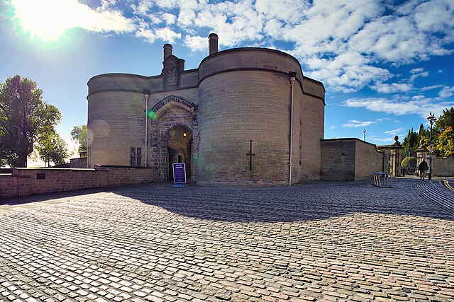
1138:== {{int:filedesc}} == {{Information |Description={{en|1=The Castle's original Norman construction began in 1068 and was added to extensively through the Medieval period. It was an important royal fortress and occasional royal residence during the Middle Ages. The site occupies a commanding position on a natural promontory known as "Castle Rock", with cliffs 130 feet high to the south and west which dominates the city skyline. The original Castle was largely demolished in 1651, after the Civ...
326:
276:
719:
268:
340:
290:
361:
43:
399:
404:
91:
963:"}},"text\/plain":{"en":{"":"ISO speed"}}},"{\"value\":{\"amount\":\"+200\",\"unit\":\"1\"},\"type\":\"quantity\"}":{"text\/html":{"en":{"P6789":"200"}},"text\/plain":{"en":{"P6789":"200"}}}}": -->
880:"}},"text\/plain":{"en":{"":"f-number"}}},"{\"value\":{\"amount\":\"+7.1\",\"unit\":\"1\"},\"type\":\"quantity\"}":{"text\/html":{"en":{"P6790":"7.1"}},"text\/plain":{"en":{"P6790":"7.1"}}}}": -->
835:"}},"text\/plain":{"en":{"":"exposure time"}}},"{\"value\":{\"amount\":\"+0.0015625\",\"unit\":\"http:\\\/\\\/www.wikidata.org\\\/entity\\\/Q11574\"},\"type\":\"quantity\"}":{"text\/html":{"en":{"P6757":"0.0015625
1001:"}},"text\/plain":{"en":{"":"media type"}}},"{\"value\":\"image\\\/jpeg\",\"type\":\"string\"}":{"text\/html":{"en":{"P1163":"image\/jpeg"}},"text\/plain":{"en":{"P1163":"image\/jpeg"}}}}": -->
573:"}},"text\/plain":{"en":{"":"copyright license"}}},"{\"value\":{\"entity-type\":\"item\",\"numeric-id\":19068220,\"id\":\"Q19068220\"},\"type\":\"wikibase-entityid\"}":{"text\/html":{"en":{"P275":"
529:"}},"text\/plain":{"en":{"":"copyright status"}}},"{\"value\":{\"entity-type\":\"item\",\"numeric-id\":50423863,\"id\":\"Q50423863\"},\"type\":\"wikibase-entityid\"}":{"text\/html":{"en":{"P6216":"
791:"}},"text\/plain":{"en":{"":"captured with"}}},"{\"value\":{\"entity-type\":\"item\",\"numeric-id\":47312693,\"id\":\"Q47312693\"},\"type\":\"wikibase-entityid\"}":{"text\/html":{"en":{"P4082":"
659:"}},"text\/plain":{"en":{"":"heading"}}},"{\"value\":{\"amount\":\"+202.0\",\"unit\":\"http:\\\/\\\/www.wikidata.org\\\/entity\\\/Q28390\"},\"type\":\"quantity\"}":{"text\/html":{"en":{"P7787":"202.0
918:"}},"text\/plain":{"en":{"":"focal length"}}},"{\"value\":{\"amount\":\"+9\",\"unit\":\"http:\\\/\\\/www.wikidata.org\\\/entity\\\/Q174789\"},\"type\":\"quantity\"}":{"text\/html":{"en":{"P2151":"9
1039:"}},"text\/plain":{"en":{"":"instance of"}}},"{\"value\":{\"entity-type\":\"item\",\"numeric-id\":125191,\"id\":\"Q125191\"},\"type\":\"wikibase-entityid\"}":{"text\/html":{"en":{"P31":"
727:"}},"text\/plain":{"en":{"":"heading"}}},"{\"value\":{\"amount\":\"+202\",\"unit\":\"http:\\\/\\\/www.wikidata.org\\\/entity\\\/Q28390\"},\"type\":\"quantity\"}":{"text\/html":{"en":{"P7787":"202
1121:
997:
259:
451:– You must give appropriate credit, provide a link to the license, and indicate if changes were made. You may do so in any reasonable manner, but not in any way that suggests the licensor endorses you or your use.
273:
323:
149:
and parts of the ramparts, but sufficient portions remain to give an impression of the layout of the site and it is protected as a
Scheduled Ancient Monument (List Entry 1006382 Historic England).
57:
53:
47:
70:
102:
792:
574:
530:
1040:
998:
960:
915:
877:
832:
788:
724:
720:
656:
652:
526:
614:
570:
1036:
1337:
155:
Although the castle is owned by
Nottingham City Council, it is operated by an independent charitable trust called the Nottingham Castle Trust.
577:"}},"text\/plain":{"en":{"P275":"Creative Commons Attribution-ShareAlike 2.0 Generic"}}}}": -->
196:
818:
600:
556:
333:
283:
368:
1183:
This file contains additional information, probably added from the digital camera or scanner used to create or digitize it.
1066:
458:
1120:
1115:
1008:
970:
929:
887:
846:
802:
765:
738:
697:
670:
540:
61:
42:
624:
584:
515:
1050:
1344:
795:"}},"text\/plain":{"en":{"P4082":"Panasonic Lumix DC-G9"}}}}": -->
414:
1186:
If the file has been modified from its original state, some details may not fully reflect the modified file.
839:"}},"text\/plain":{"en":{"P6757":"0.0015625 second"}}}}": -->
457:– If you remix, transform, or build upon the material, you must distribute your contributions under the
375:
on the
Geograph website for the photographer's contact details. The copyright on this image is owned by
922:"}},"text\/plain":{"en":{"P2151":"9 millimetre"}}}}": -->
663:"}},"text\/plain":{"en":{"P7787":"202.0 degree"}}}}": -->
533:"}},"text\/plain":{"en":{"P6216":"copyrighted"}}}}": -->
731:"}},"text\/plain":{"en":{"P7787":"202 degree"}}}}": -->
1043:"}},"text\/plain":{"en":{"P31":"photograph"}}}}": -->
110:
1434:
1170:
1131:
411:
212:
8:
355:
339:
289:
1555:
380:
97:
505:
228:
1510:
1452:
1220:
146:
cliffs 130 feet high to the south and west which dominates the city skyline.
185:
175:
1565:
1520:
1252:
1060:
1018:
980:
939:
897:
856:
812:
748:
680:
634:
594:
550:
1363:
360:
1240:
1152:
372:
1195:
153:
as a Grade I listed building (List Entry 1247094 Historic
England).
1575:
1230:
1088:
Click on a date/time to view the file as it appeared at that time.
325:
275:
260:
52° 57′ 03.02″ N, 1° 09′ 13.3″ W
1205:
310:
52° 57′ 02.1″ N, 1° 09′ 14″ W
164:
85:
499:
Add a one-line explanation of what this file represents
1146:
1161:
1086:
203:
Creative
Commons Attribution Share-alike license 2.0
109:
Commons is a freely licensed media file repository.
75:(1,024 × 683 pixels, file size: 1.06 MB, MIME type:
601:
Creative
Commons Attribution-ShareAlike 2.0 Generic
575:
Creative
Commons Attribution-ShareAlike 2.0 Generic
135:Nottingham Castle Gatehouse (geograph 7313799).jpg
468:https://creativecommons.org/licenses/by-sa/2.0
90:
474:Creative Commons Attribution-Share Alike 2.0
392:
191:
160:
132:
181:
170:
14:
919:
836:
728:
660:
434:– to copy, distribute and transmit the work
1163:The following other wikis use this file:
332:View this and other nearby images on:
282:View this and other nearby images on:
235:
121:
379:and is licensed for reuse under the
300:
250:
1148:The following page uses this file:
1079:
415:Attribution-Share Alike 2.0 Generic
403:
398:
383:Attribution-ShareAlike 2.0 license.
13:
1181:
504:
498:
389:
366:
139:
122:
68:
1648:
1188:
503:
1212:Date and time of data generation
671:coordinates of the point of view
653:coordinates of the point of view
489:
445:Under the following conditions:
410:This file is licensed under the
402:
397:
391:
359:
338:
324:
316:
288:
274:
266:
89:
31:
21:
486:
140:
1158:
1083:
485:
367:This image was taken from the
26:
1:
1489:A directly photographed image
739:coordinates of depicted place
721:coordinates of depicted place
36:
1447:3.2645364064955 APEX (f/3.1)
1418:DateTimeDigitized subseconds
1143:
511:Items portrayed in this file
351:
315:
265:
7:
1410:DateTimeOriginal subseconds
1394:Date and time of digitizing
1318:Subsampling ratio of Y to C
1178:
686:52°57'3.017"N, 1°9'13.338"W
243:Nottingham Castle Gatehouse
224:Nottingham Castle Gatehouse
10:
1653:
1531:Focal length in 35 mm film
1473:One-chip color area sensor
1355:Supported Flashpix version
1167:Usage on sr.wikipedia.org
459:same or compatible license
129:
124:
1617:Geodetic survey data used
1373:Meaning of each component
1326:File change date and time
1080:
754:52°57'2.12"N, 1°9'13.79"W
16:
488:
425:
241:David Dixon /
222:David Dixon /
96:This is a file from the
41:
1596:Measurement in progress
1585:GPS time (atomic clock)
1494:Custom image processing
1137:
213:required by the license
163:
100:. Information from its
1397:11:29, 13 October 2022
1329:11:29, 13 October 2022
1215:11:29, 13 October 2022
373:this photograph's page
344:52.950590; -1.153830
294:52.950838; -1.153705
103:description page there
46:Size of this preview:
1609:Measurement precision
1444:Maximum land aperture
1294:Horizontal resolution
1225:1/640 sec (0.0015625)
819:Panasonic Lumix DC-G9
793:Panasonic Lumix DC-G9
1481:Digital still camera
1402:DateTime subseconds
1338:PaintShop Pro 24.00
1302:Vertical resolution
1192:Camera manufacturer
440:– to adapt the work
52:Other resolutions:
1539:Scene capture type
1515:Auto white balance
62:1,024 × 683 pixels
1640:
1639:
1429:Aperture priority
1159:Global file usage
1141:
1116:18:48, 2 May 2023
921:
838:
730:
662:
585:copyright license
571:copyright license
497:
388:
387:
371:collection. See
349:
348:
299:
298:
248:
247:
216:
200:
197:Reusing this file
118:
117:
98:Wikimedia Commons
32:Global file usage
1644:
1601:Measurement mode
1426:Exposure Program
1189:
1128:
1090:
948:
865:
776:
775:
770:
708:
707:
702:
541:copyright status
527:copyright status
495:
481:
478:
475:
472:
469:
461:as the original.
423:
412:Creative Commons
406:
405:
401:
400:
395:
394:
381:Creative Commons
369:Geograph project
363:
356:
345:
342:
328:
327:
321:
320:
319:
313:
312:
301:
295:
292:
278:
277:
271:
270:
269:
263:
262:
251:
210:
194:
166:
144:
136:
130:
114:
93:
92:
86:
80:
78:
65:
58:640 × 427 pixels
54:320 × 213 pixels
48:800 × 534 pixels
1652:
1651:
1647:
1646:
1645:
1643:
1642:
1641:
1633:GPS tag version
1628:13 October 2022
1593:Receiver status
1265:52° 57′ 3.04″ N
1177:
1157:
1142:
1134:
1133:Chocolateediter
1126:
1082:
1081:
1078:
1077:
1076:
1075:
1074:
1073:
1072:
1071:
1069:
1057:
1056:
1055:
1053:
1034:
1033:
1032:
1031:
1030:
1029:
1028:
1027:
1025:
1015:
1014:
1013:
1011:
996:
995:
994:
993:
992:
991:
990:
989:
987:
977:
976:
975:
973:
958:
957:
956:
955:
954:
953:
952:
951:
949:
946:
936:
935:
934:
932:
913:
912:
911:
910:
909:
908:
907:
906:
904:
894:
893:
892:
890:
875:
874:
873:
872:
871:
870:
869:
868:
866:
863:
853:
852:
851:
849:
830:
829:
828:
827:
826:
825:
824:
823:
821:
809:
808:
807:
805:
786:
785:
784:
783:
782:
781:
780:
779:
778:
777:
773:
771:
768:
759:
758:
757:
755:
745:
744:
743:
741:
718:
717:
716:
715:
714:
713:
712:
711:
710:
709:
705:
703:
700:
691:
690:
689:
687:
677:
676:
675:
673:
650:
649:
648:
647:
646:
645:
644:
643:
641:
640:13 October 2022
631:
630:
629:
627:
612:
611:
610:
609:
608:
607:
606:
605:
603:
591:
590:
589:
587:
568:
567:
566:
565:
564:
563:
562:
561:
559:
547:
546:
545:
543:
524:
523:
522:
521:
520:
518:
502:
501:
500:
483:
482:
479:
476:
473:
470:
467:
466:
424:
421:
418:
407:
384:
354:
343:
317:
308:
307:
304:Object location
293:
267:
258:
257:
254:Camera location
249:
238:
231:
219:
176:geograph.org.uk
165:13 October 2022
156:
134:
127:
120:
119:
108:
107:
106:is shown below.
82:
76:
74:
67:
66:
51:
12:
11:
5:
1650:
1638:
1637:
1634:
1630:
1629:
1626:
1622:
1621:
1618:
1614:
1613:
1610:
1606:
1605:
1602:
1598:
1597:
1594:
1590:
1589:
1586:
1582:
1581:
1578:
1572:
1571:
1568:
1562:
1561:
1558:
1552:
1551:
1548:
1544:
1543:
1540:
1536:
1535:
1532:
1528:
1527:
1524:
1517:
1516:
1513:
1507:
1506:
1503:
1499:
1498:
1497:Normal process
1495:
1491:
1490:
1487:
1483:
1482:
1479:
1475:
1474:
1471:
1470:Sensing method
1467:
1466:
1463:
1459:
1458:
1455:
1449:
1448:
1445:
1441:
1440:
1437:
1431:
1430:
1427:
1423:
1422:
1419:
1415:
1414:
1411:
1407:
1406:
1403:
1399:
1398:
1395:
1391:
1390:
1389:
1388:
1387:does not exist
1385:
1382:
1379:
1374:
1370:
1369:
1366:
1360:
1359:
1356:
1352:
1351:
1348:
1341:
1340:
1335:
1331:
1330:
1327:
1323:
1322:
1319:
1315:
1314:
1311:
1307:
1306:
1303:
1299:
1298:
1295:
1291:
1290:
1287:
1283:
1282:
1279:
1275:
1274:
1273:1° 9′ 13.31″ W
1271:
1267:
1266:
1263:
1259:
1258:
1255:
1248:
1247:
1244:
1237:
1236:
1233:
1227:
1226:
1223:
1217:
1216:
1213:
1209:
1208:
1203:
1199:
1198:
1193:
1180:
1176:
1175:
1174:
1173:
1160:
1156:
1155:
1145:
1140:
1139:
1136:
1132:
1129:
1123:
1118:
1113:
1109:
1108:
1105:
1102:
1099:
1096:
1093:
1085:
1070:
1065:
1063:
1062:
1061:
1059:
1058:
1054:
1049:
1047:
1046:
1045:
1044:
1042:
1038:
1026:
1023:
1021:
1020:
1019:
1017:
1016:
1012:
1007:
1005:
1004:
1003:
1002:
1000:
988:
985:
983:
982:
981:
979:
978:
974:
969:
967:
966:
965:
964:
962:
950:
944:
942:
941:
940:
938:
937:
933:
928:
926:
925:
924:
923:
917:
905:
902:
900:
899:
898:
896:
895:
891:
886:
884:
883:
882:
881:
879:
867:
861:
859:
858:
857:
855:
854:
850:
845:
843:
842:
841:
840:
834:
822:
817:
815:
814:
813:
811:
810:
806:
801:
799:
798:
797:
796:
794:
790:
764:
763:
762:
761:
760:
756:
753:
751:
750:
749:
747:
746:
742:
737:
735:
734:
733:
732:
726:
722:
696:
695:
694:
693:
692:
688:
685:
683:
682:
681:
679:
678:
674:
669:
667:
666:
665:
664:
658:
654:
642:
639:
637:
636:
635:
633:
632:
628:
623:
621:
620:
619:
618:
616:
604:
599:
597:
596:
595:
593:
592:
588:
583:
581:
580:
579:
578:
576:
572:
560:
555:
553:
552:
551:
549:
548:
544:
539:
537:
536:
535:
534:
532:
528:
519:
514:
512:
509:
508:
507:
506:
494:
493:
490:
487:
465:
464:
463:
462:
452:
443:
442:
441:
435:
428:You are free:
419:
409:
408:
390:
386:
385:
364:
353:
350:
347:
346:
336:
330:
305:
297:
296:
286:
280:
255:
246:
245:
239:
236:
233:
232:
227:
220:
217:
205:
204:
201:
189:
188:
183:
179:
178:
172:
168:
167:
162:
158:
157:
137:
128:
126:
123:
116:
115:
94:
84:
83:
45:
40:
39:
34:
29:
24:
19:
9:
6:
4:
3:
2:
1649:
1635:
1632:
1631:
1627:
1624:
1623:
1619:
1616:
1615:
1612:Excellent (0)
1611:
1608:
1607:
1603:
1600:
1599:
1595:
1592:
1591:
1587:
1584:
1583:
1579:
1577:
1574:
1573:
1569:
1567:
1564:
1563:
1559:
1557:
1554:
1553:
1549:
1547:Scene control
1546:
1545:
1541:
1538:
1537:
1533:
1530:
1529:
1525:
1522:
1519:
1518:
1514:
1512:
1511:White balance
1509:
1508:
1505:Auto exposure
1504:
1502:Exposure mode
1501:
1500:
1496:
1493:
1492:
1488:
1485:
1484:
1480:
1477:
1476:
1472:
1469:
1468:
1464:
1461:
1460:
1456:
1454:
1453:Metering mode
1451:
1450:
1446:
1443:
1442:
1438:
1436:
1435:Exposure bias
1433:
1432:
1428:
1425:
1424:
1420:
1417:
1416:
1412:
1409:
1408:
1404:
1401:
1400:
1396:
1393:
1392:
1386:
1383:
1380:
1377:
1376:
1375:
1372:
1371:
1367:
1365:
1362:
1361:
1357:
1354:
1353:
1349:
1346:
1343:
1342:
1339:
1336:
1334:Software used
1333:
1332:
1328:
1325:
1324:
1320:
1317:
1316:
1312:
1309:
1308:
1304:
1301:
1300:
1296:
1293:
1292:
1288:
1285:
1284:
1280:
1277:
1276:
1272:
1269:
1268:
1264:
1261:
1260:
1256:
1254:
1250:
1249:
1245:
1242:
1239:
1238:
1234:
1232:
1229:
1228:
1224:
1222:
1221:Exposure time
1219:
1218:
1214:
1211:
1210:
1207:
1204:
1201:
1200:
1197:
1194:
1191:
1190:
1187:
1184:
1172:
1169:
1168:
1166:
1165:
1164:
1154:
1151:
1150:
1149:
1135:
1130:
1124:
1122:
1119:
1117:
1114:
1111:
1110:
1106:
1103:
1100:
1097:
1094:
1092:
1091:
1089:
1068:
1064:
1052:
1048:
1022:
1010:
1006:
984:
972:
968:
943:
931:
927:
901:
889:
885:
860:
848:
847:exposure time
844:
833:exposure time
820:
816:
804:
803:captured with
800:
789:captured with
767:
752:
740:
736:
699:
684:
672:
668:
638:
626:
622:
602:
598:
586:
582:
558:
554:
542:
538:
517:
513:
510:
491:
484:
471:CC BY-SA 2.0
460:
456:
453:
450:
447:
446:
444:
439:
436:
433:
430:
429:
427:
426:
420:Attribution:
416:
413:
396:
382:
378:
374:
370:
365:
362:
358:
357:
341:
337:
335:
334:OpenStreetMap
331:
329:
311:
306:
303:
302:
291:
287:
285:
284:OpenStreetMap
281:
279:
261:
256:
253:
252:
244:
240:
234:
230:
226: /
225:
221:
214:
209:
207:
206:
202:
198:
193:
190:
187:
184:
180:
177:
173:
169:
159:
154:
150:
143:
138:
131:
112:
105:
104:
99:
95:
88:
87:
81:
72:
71:Original file
63:
59:
55:
49:
44:
38:
35:
33:
30:
28:
25:
23:
20:
18:
15:
1521:Digital zoom
1462:Light source
1253:focal length
1202:Camera model
1185:
1182:
1162:
1147:
1125:1,024 × 683
1087:
1084:File history
930:focal length
916:focal length
454:
448:
437:
431:
376:
314:
264:
242:
229:CC BY-SA 2.0
223:
151:
147:
141:
111:You can help
101:
69:
22:File history
1550:Low gain up
1478:File source
1364:Color space
1310:Orientation
1051:instance of
1037:instance of
557:copyrighted
531:copyrighted
455:share alike
449:attribution
422:David Dixon
377:David Dixon
208:Attribution
186:David Dixon
133:Description
1566:Saturation
1486:Scene type
1153:Nottingham
1144:File usage
1101:Dimensions
1067:photograph
1041:photograph
1024:image/jpeg
1009:media type
999:media type
947:millimetre
920:millimetre
862:0.0015625
192:Permission
77:image/jpeg
27:File usage
1620:WGS-84
1576:Sharpness
1270:Longitude
1241:ISO speed
1196:Panasonic
1127:(1.06 MB)
1098:Thumbnail
1095:Date/Time
971:ISO speed
961:ISO speed
625:inception
615:inception
352:Licensing
237:InfoField
218:InfoField
142:English:
1625:GPS date
1556:Contrast
1542:Standard
1281:1,024 px
1262:Latitude
1231:F-number
1179:Metadata
1171:Нотингем
888:f-number
878:f-number
492:Captions
438:to remix
432:to share
417:license.
37:Metadata
1636:0.0.3.2
1465:Unknown
1457:Pattern
1347:version
1305:240 dpi
1297:240 dpi
1112:current
1107:Comment
766:heading
725:heading
698:heading
657:heading
516:depicts
496:English
125:Summary
73:
1580:Normal
1570:Normal
1560:Normal
1313:Normal
1289:683 px
1286:Height
1243:rating
864:second
837:second
774:degree
729:degree
706:degree
704:202.0
661:degree
322:
272:
182:Author
171:Source
1588:10:29
1534:18 mm
1523:ratio
1278:Width
1251:Lens
1235:f/7.1
1206:DC-G9
174:From
1368:sRGB
1350:2.31
1345:Exif
1257:9 mm
1104:User
772:202
480:true
477:true
161:Date
17:File
1421:240
1413:240
1405:240
1246:200
986:200
903:7.1
1384:Cr
1381:Cb
945:9
769::
701::
60:|
56:|
50:.
1604:0
1526:0
1439:0
1378:Y
1358:1
1321:1
215:)
211:(
199:)
195:(
113:.
79:)
64:.
Text is available under the Creative Commons Attribution-ShareAlike License. Additional terms may apply.

.jpg)
.jpg¶ms=052.950838_N_-001.153705_E_globe:Earth_type:camera_source:geograph-osgb36(SK5695839608)_heading:202.00&language=en)
.jpg¶ms=052.950590_N_-001.153830_E_globe:Earth_class:object_type:object_source:geograph-osgb36(SK56953958)_heading:202.00&language=en)
