47:
522:
34:
54:
340:
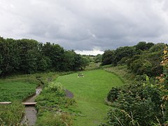
in the past of which very little is now visible. Part of the valley is now the
Brierdene Community Green Space and the Brierdene Wildlife Site. The site is now home to more than 1000 identified organisms and includes a ecologically diverse meadow and is a designated
208:
248:
112:
85:
345:. Much of work of transforming the valley into a wildlife refuge was undertaken by a voluntary group - the Friends of Brierdene. This work earned them a
232:
563:
194:
587:
342:
256:
292:
46:
225:
491:
220:
556:
346:
274:
284:
182:
148:
549:
78:
237:
376:
353:
279:
359:
In April 2016 a new housing development at
Backworth was started and adopted the name of Brierdene.
162:
582:
94:
8:
447:
356:
was also used for a railway station built in 1914 but which was never brought into use.
213:
138:
130:
401:
521:
537:
187:
33:
533:
102:
332:
is a small valley through which the
Brierdene Burn flows down to its mouth at
576:
529:
307:
294:
120:
67:
333:
337:
172:
492:"Work starts on building 180 new homes in Backworth, North Tyneside"
468:
423:
154:
574:
557:
564:
550:
575:
489:
343:Site of Nature Conservation Importance
336:. The valley was partly occupied by a
396:
394:
516:
442:
440:
404:. Go-curate- University of Newcastle
13:
391:
347:Queens Award for Voluntary Service
14:
599:
437:
53:
520:
52:
45:
32:
490:Sharma, Sonia (27 March 2016).
483:
461:
416:
369:
1:
588:Tyne and Wear geography stubs
362:
536:. You can help Knowledge by
377:"Brier Dene, North Tyneside"
7:
79:OS grid reference
21:Human settlement in England
10:
604:
515:
448:"Brierdene Wildlife Site"
265:
247:
243:
231:
219:
207:
203:
193:
181:
171:
161:
147:
129:
111:
95:Metropolitan borough
93:
77:
40:
31:
26:
113:Metropolitan county
16:Stream valley in England
424:"Brierdene - Coal mine"
532:location article is a
469:"Friends of Brierdene"
183:Postcode district
163:Sovereign state
304: /
249:UK Parliament
195:Dialling code
545:
544:
379:. Ordnance Survey
323:
322:
595:
566:
559:
552:
524:
517:
507:
506:
504:
502:
487:
481:
480:
478:
476:
465:
459:
458:
456:
454:
444:
435:
434:
432:
430:
420:
414:
413:
411:
409:
398:
389:
388:
386:
384:
373:
319:
318:
316:
315:
314:
309:
305:
302:
301:
300:
297:
271:
157:
89:
88:
66:Location within
56:
55:
49:
36:
24:
23:
603:
602:
598:
597:
596:
594:
593:
592:
573:
572:
571:
570:
513:
511:
510:
500:
498:
488:
484:
474:
472:
467:
466:
462:
452:
450:
446:
445:
438:
428:
426:
422:
421:
417:
407:
405:
400:
399:
392:
382:
380:
375:
374:
370:
365:
312:
310:
306:
303:
298:
295:
293:
291:
290:
289:
269:
261:
153:
143:
125:
107:
84:
83:
73:
72:
71:
70:
64:
63:
62:
61:
57:
22:
17:
12:
11:
5:
601:
591:
590:
585:
569:
568:
561:
554:
546:
543:
542:
525:
509:
508:
482:
460:
436:
415:
390:
367:
366:
364:
361:
321:
320:
308:55.06°N 1.45°W
288:
287:
282:
277:
272:
270:List of places
266:
263:
262:
260:
259:
253:
251:
245:
244:
241:
240:
235:
229:
228:
223:
217:
216:
211:
205:
204:
201:
200:
197:
191:
190:
185:
179:
178:
175:
169:
168:
167:United Kingdom
165:
159:
158:
151:
145:
144:
142:
141:
135:
133:
127:
126:
124:
123:
117:
115:
109:
108:
106:
105:
103:North Tyneside
99:
97:
91:
90:
81:
75:
74:
65:
59:
58:
51:
50:
44:
43:
42:
41:
38:
37:
29:
28:
20:
15:
9:
6:
4:
3:
2:
600:
589:
586:
584:
581:
580:
578:
567:
562:
560:
555:
553:
548:
547:
541:
539:
535:
531:
530:Tyne and Wear
526:
523:
519:
518:
514:
497:
496:ChronicleLive
493:
486:
470:
464:
449:
443:
441:
425:
419:
403:
397:
395:
378:
372:
368:
360:
357:
355:
350:
348:
344:
339:
335:
331:
327:
317:
286:
285:Tyne and Wear
283:
281:
278:
276:
273:
268:
267:
264:
258:
255:
254:
252:
250:
246:
242:
239:
236:
234:
230:
227:
226:Tyne and Wear
224:
222:
218:
215:
212:
210:
206:
202:
198:
196:
192:
189:
186:
184:
180:
176:
174:
170:
166:
164:
160:
156:
152:
150:
146:
140:
137:
136:
134:
132:
128:
122:
121:Tyne and Wear
119:
118:
116:
114:
110:
104:
101:
100:
98:
96:
92:
87:
82:
80:
76:
69:
68:Tyne and Wear
48:
39:
35:
30:
25:
19:
538:expanding it
527:
512:
499:. Retrieved
495:
485:
473:. Retrieved
463:
451:. Retrieved
427:. Retrieved
418:
406:. Retrieved
381:. Retrieved
371:
358:
351:
329:
325:
324:
313:55.06; -1.45
18:
583:Whitley Bay
402:"Brierdene"
334:Whitley Bay
311: /
214:Northumbria
177:WHITLEY BAY
577:Categories
363:References
330:Brier Dene
238:North East
139:North East
354:Brierdene
352:The name
338:coal mine
326:Brierdene
257:Tynemouth
233:Ambulance
173:Post town
60:Brierdene
27:Brierdene
475:11 June
453:11 June
429:11 June
408:11 June
383:11 June
296:55°04′N
280:England
155:England
149:Country
501:7 June
471:. VODA
299:1°27′W
209:Police
131:Region
86:NZ3474
528:This
534:stub
503:2023
477:2023
455:2023
431:2023
410:2023
385:2023
221:Fire
199:0191
188:NE26
328:or
579::
494:.
439:^
393:^
349:.
275:UK
565:e
558:t
551:v
540:.
505:.
479:.
457:.
433:.
412:.
387:.
Text is available under the Creative Commons Attribution-ShareAlike License. Additional terms may apply.

