110:
80:
55:
117:
87:
109:
79:
481:
54:
142:
1173:
452:
408:
1127:
376:
1168:
522:
472:
1005:
364:
1132:
198:
1071:
970:
680:
445:
19:
This article is about the subdivision of
Dungannon created in 1837. For an earlier use of the name, see
905:
815:
570:
885:
690:
565:
810:
735:
174:
1137:
880:
770:
1041:
925:
900:
705:
670:
620:
615:
438:
1142:
830:
825:
383:
1051:
790:
645:
8:
930:
1026:
890:
227:
412:
1089:
1079:
580:
235:
223:
215:
191:
64:
20:
1084:
1061:
1046:
635:
1147:
1114:
1109:
915:
700:
595:
243:
179:
43:
1162:
462:
239:
219:
203:
157:
144:
60:
234:
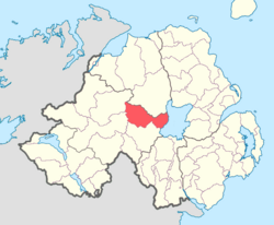
runs along its eastern boundary, and it is bordered by four other baronies:
960:
875:
870:
840:
765:
575:
430:
1010:
1000:
995:
950:
860:
715:
630:
600:
304:
231:
1104:
1099:
990:
980:
955:
920:
855:
800:
795:
785:
685:
650:
640:
555:
530:
489:
274:
247:
1036:
1031:
975:
945:
940:
895:
850:
780:
775:
730:
675:
535:
499:
494:
269:
1056:
985:
965:
910:
865:
845:
835:
820:
745:
725:
720:
625:
610:
550:
509:
760:
710:
665:
655:
585:
540:
336:
186:
935:
805:
740:
695:
605:
590:
560:
545:
312:
259:
755:
750:
660:
504:
264:
226:. It was created in 1851 with the splitting of the barony of
343:. Department of Community, Rural and Gaeltacht Affairs
285:
Below is a list of civil parishes in
Dungannon Upper:
377:"Notes on Baronies of Ireland 1821-1891, page 14"
1160:
295:Ballinderry (split with barony of Loughinsholin)
301:Derryloran (split with barony of Loughinsholin)
446:
318:Tamlaght (split with barony of Loughinsholin)
460:
292:Artrea (split with barony of Loughinsholin)
253:
453:
439:
289:Arboe (split with barony of Loughinsholin)
280:
28:Place in Northern Ireland, United Kingdom
16:Barony in County Tyrone, Northern Ireland
315:(also partly in barony of Loughinsholin)
369:
360:
358:
116:
86:
1161:
329:
434:
401:
355:
13:
365:PRONI Baronies of Northern Ireland
14:
1185:
409:"PRONI Parishes of County Tyrone"
115:
108:
85:
78:
53:
473:List of places in County Tyrone
1174:1851 establishments in Ireland
341:Placenames Database of Ireland
1:
322:
59:Location of Dungannon Upper,
1128:WikiProject Northern Ireland
129:Show map of Northern Ireland
7:
10:
1190:
18:
1169:Barony of Dungannon Upper
1123:
1070:
1019:
518:
480:
469:
197:
185:
173:
138:
99:Show map of County Tyrone
72:
52:
33:
254:List of main settlements
1138:Northern Ireland Portal
246:to the north-west; and
40:Dún Geanainn Uachtarach
1042:Drum Manor Forest Park
281:List of civil parishes
1143:United Kingdom Portal
1052:Mountains of Pomeroy
1133:WikiProject Ireland
250:to the south-west.
154: /
1027:Ballysaggart Lough
158:54.6525°N 6.7548°W
1156:
1155:
337:"Dungannon Upper"
209:
208:
47:
1181:
1090:Dungannon Middle
581:Ballymully Glebe
455:
448:
441:
432:
431:
425:
424:
422:
420:
411:. Archived from
405:
399:
398:
396:
394:
389:on 12 March 2016
388:
382:. Archived from
381:
373:
367:
362:
353:
352:
350:
348:
333:
236:Dungannon Middle
224:Northern Ireland
192:Northern Ireland
169:
168:
166:
165:
164:
163:54.6525; -6.7548
159:
155:
152:
151:
150:
147:
130:
119:
118:
112:
100:
89:
88:
82:
65:Northern Ireland
57:
38:
31:
30:
21:Clogher (barony)
1189:
1188:
1184:
1183:
1182:
1180:
1179:
1178:
1159:
1158:
1157:
1152:
1119:
1095:Dungannon Upper
1085:Dungannon Lower
1066:
1062:Tullyhogue Fort
1015:
1006:Victoria Bridge
636:Castlecaulfield
520:
514:
476:
465:
459:
429:
428:
418:
416:
415:on 27 July 2011
407:
406:
402:
392:
390:
386:
379:
375:
374:
370:
363:
356:
346:
344:
335:
334:
330:
325:
283:
256:
212:Dungannon Upper
175:Sovereign state
162:
160:
156:
153:
148:
145:
143:
141:
140:
134:
133:
132:
131:
128:
127:
126:
125:
124:
123:Dungannon Upper
120:
103:
102:
101:
98:
97:
96:
95:
94:
93:Dungannon Upper
90:
68:
48:
36:
35:Dungannon Upper
29:
24:
17:
12:
11:
5:
1187:
1177:
1176:
1171:
1154:
1153:
1151:
1150:
1148:Ireland Portal
1145:
1140:
1135:
1130:
1124:
1121:
1120:
1118:
1117:
1115:Strabane Upper
1112:
1110:Strabane Lower
1107:
1102:
1097:
1092:
1087:
1082:
1076:
1074:
1068:
1067:
1065:
1064:
1059:
1054:
1049:
1044:
1039:
1034:
1029:
1023:
1021:
1017:
1016:
1014:
1013:
1008:
1003:
998:
993:
988:
983:
978:
973:
968:
963:
958:
953:
948:
943:
938:
933:
928:
923:
918:
916:Newtownstewart
913:
908:
903:
898:
893:
888:
883:
878:
873:
868:
863:
858:
853:
848:
843:
838:
833:
828:
823:
818:
813:
808:
803:
798:
793:
788:
783:
778:
773:
768:
763:
758:
753:
748:
743:
738:
733:
728:
723:
718:
713:
708:
703:
701:Douglas Bridge
698:
693:
688:
683:
678:
673:
668:
663:
658:
653:
648:
643:
638:
633:
628:
623:
618:
613:
608:
603:
598:
596:Blackwatertown
593:
588:
583:
578:
573:
568:
563:
558:
553:
548:
543:
538:
533:
527:
525:
516:
515:
513:
512:
507:
502:
497:
492:
486:
484:
478:
477:
470:
467:
466:
458:
457:
450:
443:
435:
427:
426:
400:
368:
354:
327:
326:
324:
321:
320:
319:
316:
310:
307:
302:
299:
296:
293:
290:
282:
279:
278:
277:
272:
267:
262:
255:
252:
244:Strabane Upper
242:to the north;
238:to the south;
207:
206:
201:
195:
194:
189:
183:
182:
180:United Kingdom
177:
171:
170:
136:
135:
122:
121:
114:
113:
107:
106:
105:
104:
92:
91:
84:
83:
77:
76:
75:
74:
73:
70:
69:
58:
50:
49:
37:
34:
27:
15:
9:
6:
4:
3:
2:
1186:
1175:
1172:
1170:
1167:
1166:
1164:
1149:
1146:
1144:
1141:
1139:
1136:
1134:
1131:
1129:
1126:
1125:
1122:
1116:
1113:
1111:
1108:
1106:
1103:
1101:
1098:
1096:
1093:
1091:
1088:
1086:
1083:
1081:
1078:
1077:
1075:
1073:
1069:
1063:
1060:
1058:
1055:
1053:
1050:
1048:
1045:
1043:
1040:
1038:
1035:
1033:
1030:
1028:
1025:
1024:
1022:
1018:
1012:
1009:
1007:
1004:
1002:
999:
997:
994:
992:
989:
987:
984:
982:
979:
977:
974:
972:
969:
967:
964:
962:
959:
957:
954:
952:
949:
947:
944:
942:
939:
937:
934:
932:
929:
927:
924:
922:
919:
917:
914:
912:
909:
907:
904:
902:
899:
897:
894:
892:
889:
887:
884:
882:
879:
877:
874:
872:
869:
867:
864:
862:
859:
857:
854:
852:
849:
847:
844:
842:
839:
837:
834:
832:
829:
827:
824:
822:
819:
817:
814:
812:
809:
807:
804:
802:
799:
797:
794:
792:
789:
787:
784:
782:
779:
777:
774:
772:
769:
767:
764:
762:
759:
757:
754:
752:
749:
747:
744:
742:
739:
737:
734:
732:
729:
727:
724:
722:
719:
717:
714:
712:
709:
707:
704:
702:
699:
697:
694:
692:
689:
687:
684:
682:
679:
677:
674:
672:
669:
667:
664:
662:
659:
657:
654:
652:
649:
647:
644:
642:
639:
637:
634:
632:
629:
627:
624:
622:
619:
617:
614:
612:
609:
607:
604:
602:
599:
597:
594:
592:
589:
587:
584:
582:
579:
577:
574:
572:
569:
567:
564:
562:
559:
557:
554:
552:
549:
547:
544:
542:
539:
537:
534:
532:
529:
528:
526:
524:
517:
511:
508:
506:
503:
501:
498:
496:
493:
491:
488:
487:
485:
483:
479:
475:
474:
468:
464:
463:County Tyrone
456:
451:
449:
444:
442:
437:
436:
433:
414:
410:
404:
385:
378:
372:
366:
361:
359:
342:
338:
332:
328:
317:
314:
311:
308:
306:
303:
300:
297:
294:
291:
288:
287:
286:
276:
273:
271:
268:
266:
263:
261:
258:
257:
251:
249:
245:
241:
240:Loughinsholin
237:
233:
229:
225:
221:
220:County Tyrone
217:
213:
205:
202:
200:
196:
193:
190:
188:
184:
181:
178:
176:
172:
167:
139:Coordinates:
137:
111:
81:
71:
66:
62:
61:County Tyrone
56:
51:
45:
41:
32:
26:
22:
1094:
971:Stewartstown
961:Sixmilecross
876:Magheramason
871:Loughmacrory
841:Killyclogher
766:Fivemiletown
681:Derrylaughan
576:Ballymagorry
471:
417:. Retrieved
413:the original
403:
391:. Retrieved
384:the original
371:
345:. Retrieved
340:
331:
284:
211:
210:
39:
25:
1011:Washing Bay
1001:Tullywiggan
996:Tullyvannon
951:Shanmaghery
906:Mullaghmore
861:Landahaussy
816:Greencastle
726:Dunnamanagh
716:Drumnakilly
631:Carrickmore
601:Brackaville
571:Ballygawley
305:Desertcreat
232:Lough Neagh
161: /
1163:Categories
1105:Omagh West
1100:Omagh East
991:Tullyhogue
981:Tattyreagh
956:Sion Mills
921:Plumbridge
886:Mountfield
856:Knockmoyle
801:Gortaclare
796:Glenmornan
786:Gillygooly
691:Donaghmore
686:Derrytresk
651:Clanabogan
641:Castlederg
566:Aughnacloy
556:Artigarvan
531:Altamuskin
490:Coalisland
461:Places in
347:4 December
323:References
275:Tullyhogue
248:Omagh East
146:54°39′09″N
1037:Black Bog
1032:Beaghmore
1020:Landforms
976:Tamnamore
946:Seskinore
941:Sandholes
896:Moygashel
851:Kilskeery
811:Granville
781:Garvetagh
776:Garvaghey
736:Edenderry
731:Dunnamore
676:Derrycrin
536:Altishane
523:townlands
500:Dungannon
495:Cookstown
393:8 October
298:Ballyclog
270:Cookstown
228:Dungannon
149:6°45′17″W
1072:Baronies
1057:Sperrins
1047:Glenelly
986:Trillick
966:Spamount
911:Newmills
881:Moortown
866:Liscloon
846:Killyman
836:Killeter
821:Kildress
771:Galbally
746:Erganagh
721:Drumquin
626:Carnteel
611:Brockagh
551:Ardstraw
519:Villages
510:Strabane
309:Kildress
1080:Clogher
926:Pomeroy
901:Moylagh
761:Fintona
711:Drumkee
706:Dromore
671:Creggan
666:Cranagh
656:Clogher
621:Cappagh
616:Caledon
586:Benburb
541:Altmore
419:15 July
187:Country
936:Rousky
831:Killen
826:Killay
806:Gortin
741:Eglish
696:Dooish
606:Bready
591:Beragh
561:Augher
546:Ardboe
313:Lissan
260:Ardboe
216:barony
204:Tyrone
199:County
791:Glebe
756:Evish
751:Eskra
661:Coagh
646:Clady
505:Omagh
482:Towns
387:(PDF)
380:(PDF)
265:Coagh
214:is a
44:Irish
931:Rock
521:and
421:2010
395:2010
349:2012
891:Moy
218:in
1165::
357:^
339:.
230:.
222:,
63:,
454:e
447:t
440:v
423:.
397:.
351:.
67:.
46:)
42:(
23:.
Text is available under the Creative Commons Attribution-ShareAlike License. Additional terms may apply.


