680:"}},"text\/plain":{"en":{"":"inception"}}},"{\"value\":{\"time\":\"+2010-11-16T00:00:00Z\",\"timezone\":0,\"before\":0,\"after\":0,\"precision\":11,\"calendarmodel\":\"http:\\\/\\\/www.wikidata.org\\\/entity\\\/Q1985727\"},\"type\":\"time\"}":{"text\/html":{"en":{"P571":"16 November 2010"}},"text\/plain":{"en":{"P571":"16 November 2010"}}}}": -->
38:
460:
364:
309:
224:
229:
94:
619:"}},"text\/plain":{"en":{"P275":"Creative Commons Attribution-ShareAlike 3.0 Unported"}}},"{\"value\":{\"entity-type\":\"item\",\"numeric-id\":50829104,\"id\":\"Q50829104\"},\"type\":\"wikibase-entityid\"}":{"text\/html":{"en":{"P275":"
472:"}},"text\/plain":{"en":{"P2093":"Nilfanion","P4174":"Nilfanion"}}},"{\"value\":{\"entity-type\":\"property\",\"numeric-id\":4174,\"id\":\"P4174\"},\"type\":\"wikibase-entityid\"}":{"text\/html":{"en":{"":"
615:"}},"text\/plain":{"en":{"":"copyright license"}}},"{\"value\":{\"entity-type\":\"item\",\"numeric-id\":14946043,\"id\":\"Q14946043\"},\"type\":\"wikibase-entityid\"}":{"text\/html":{"en":{"P275":"
571:"}},"text\/plain":{"en":{"":"copyright status"}}},"{\"value\":{\"entity-type\":\"item\",\"numeric-id\":50423863,\"id\":\"Q50423863\"},\"type\":\"wikibase-entityid\"}":{"text\/html":{"en":{"P6216":"
476:"}},"text\/plain":{"en":{"":"Wikimedia username"}}},"{\"value\":{\"entity-type\":\"property\",\"numeric-id\":2699,\"id\":\"P2699\"},\"type\":\"wikibase-entityid\"}":{"text\/html":{"en":{"":"
464:"}},"text\/plain":{"en":{"":"creator"}}},"{\"value\":{\"entity-type\":\"property\",\"numeric-id\":2093,\"id\":\"P2093\"},\"type\":\"wikibase-entityid\"}":{"text\/html":{"en":{"":"
567:
468:"}},"text\/plain":{"en":{"":"author name string"}}},"{\"value\":\"Nilfanion\",\"type\":\"string\"}":{"text\/html":{"en":{"P2093":"Nilfanion","P4174":"
480:"}},"text\/plain":{"en":{"":"URL"}}},"{\"value\":\"https:\\\/\\\/commons.wikimedia.org\\\/wiki\\\/user:Nilfanion\",\"type\":\"string\"}":{"text\/html":{"en":{"P2699":"
270:– You must give appropriate credit, provide a link to the license, and indicate if changes were made. You may do so in any reasonable manner, but not in any way that suggests the licensor endorses you or your use.
401:
469:
376:
620:
616:
572:
481:
568:
477:
473:
465:
677:
612:
461:
1301:
792:
326:
1778:
484:"}},"text\/plain":{"en":{"P2699":"https:\/\/commons.wikimedia.org\/wiki\/user:Nilfanion"}}}}": -->
1399:
68:
64:
623:"}},"text\/plain":{"en":{"P275":"GNU Free Documentation License, version 1.2 or later"}}}}": -->
60:
56:
52:
48:
42:
382:
1614:
324:; with no Invariant Sections, no Front-Cover Texts, and no Back-Cover Texts. A copy of the license is included in the section entitled
105:
77:
1454:
179:
1394:
663:
646:
598:
1769:
277:
582:
546:
531:
518:
316:
687:
630:
491:
450:
1709:
393:
538:
239:
1669:
1679:
791:
More than 100 pages use this file. The following list shows the first 100 pages that use this file only. A
321:
979:
276:– If you remix, transform, or build upon the material, you must distribute your contributions under the
575:"}},"text\/plain":{"en":{"P6216":"copyrighted"}}}}": -->
1609:
168:
984:
113:
755:
750:
553:
370:
37:
1379:
1074:
884:
314:
Permission is granted to copy, distribute and/or modify this document under the terms of the
1129:
944:
939:
834:
829:
236:
8:
1424:
1089:
814:
1169:
889:
1249:
1219:
1009:
859:
804:
1479:
1224:
1214:
1184:
1179:
1059:
1014:
819:
211:
I, the copyright holder of this work, hereby publish it under the following licenses:
100:
1699:
440:
1274:
1264:
1234:
1049:
929:
904:
894:
165:
1369:
1604:
1139:
1119:
969:
924:
778:
195:
1514:
1289:
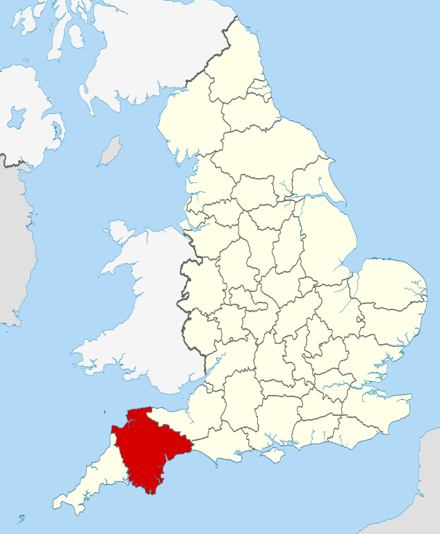
989:
954:
919:
766:
773:== Summary == {{Information |Description=Location of the ceremonial county of
1279:
1209:
1199:
1194:
1044:
999:
994:
874:
839:
1339:
1389:
1189:
1039:
799:
402:
Commons:Valued image candidates/Locator maps of
English ceremonial counties
697:
657:
640:
592:
501:
1259:
1254:
1134:
1069:
1054:
1019:
974:
844:
1624:
1284:
1204:
1164:
1159:
1149:
1084:
1079:
1029:
959:
949:
899:
869:
849:
1749:
185:
Irish, French and Isle of Man coastlines, Lough Neagh and Irish border
1499:
1294:
1269:
1244:
1024:
964:
934:
909:
879:
824:
1654:
358:
303:
1239:
1154:
1144:
1109:
1004:
914:
864:
854:
723:
Click on a date/time to view the file as it appeared at that time.
1444:
1229:
1174:
1114:
1099:
1064:
381:
on
Wikimedia Commons. The image set has been assessed under the
1524:
1124:
1104:
809:
143:
1434:
1094:
1034:
774:
82:(SVG file, nominally 1,108 × 1,345 pixels, file size: 302 KB)
1574:
154:
88:
1409:
426:
Add a one-line explanation of what this file represents
1689:
789:
482:
https:\/\/commons.wikimedia.org\/wiki\/user:Nilfanion
1634:
1310:
721:
664:
647:
Creative
Commons Attribution-ShareAlike 3.0 Unported
621:
617:
Creative
Commons Attribution-ShareAlike 3.0 Unported
320:, Version 1.2 or any later version published by the
112:
Commons is a freely licensed media file repository.
1739:
1729:
1664:
1644:
1564:
1534:
1464:
1349:
1759:
1719:
1594:
1584:
1554:
1544:
1509:
1489:
1474:
1419:
1359:
1329:
1319:
377:Locator maps of the Ceremonial counties of England
1670:Apvienotās Karalistes administratīvais iedalījums
1425:Llista de comtats cerimonials d'Anglaterra
369:This is one of the images forming part of the
287:https://creativecommons.org/licenses/by-sa/3.0
93:
293:Creative Commons Attribution-Share Alike 3.0
217:
150:
135:
554:https://commons.wikimedia.org/user:Nilfanion
191:
160:
14:
253:– to copy, distribute and transmit the work
41:Size of this PNG preview of this SVG file:
352:You may select the license of your choice.
1480:Anexo:Condados ceremoniales de Inglaterra
1312:The following other wikis use this file:
180:National Geospatial-Intelligence Agency
1700:Comtats ceremonials d'Anglatèrra
142:Location of the ceremonial county of
124:
434:расположение Девона на карте Англии.
332:http://www.gnu.org/copyleft/fdl.html
240:Attribution-Share Alike 3.0 Unported
714:
228:
223:
13:
1515:Englannin muodolliset kreivikunnat
439:
433:
425:
390:
351:
214:
210:
175:County boundaries and GB coastline
125:
75:
1790:
1366:Usage on be-tarask.wikipedia.org
438:
416:
362:
308:
307:
264:Under the following conditions:
235:This file is licensed under the
227:
222:
216:
92:
31:
21:
413:
363:
1686:Usage on nds-nl.wikipedia.org
1307:
718:
412:
399:You can see its nomination at
394:Ceremonial counties of England
387:the most valued set on Commons
338:GNU Free Documentation License
327:GNU Free Documentation License
317:GNU Free Documentation License
26:
1:
138:Devon UK locator map 2010.svg
786:
446:Items portrayed in this file
204:
7:
1746:Usage on pnb.wikipedia.org
1736:Usage on pl.wiktionary.org
1726:Usage on pl.wikivoyage.org
1641:Usage on lld.wikipedia.org
1561:Usage on hak.wikipedia.org
1531:Usage on fr.wiktionary.org
1431:Usage on ceb.wikipedia.org
1406:Usage on br.wiktionary.org
1346:Usage on ast.wikipedia.org
1336:Usage on arz.wikipedia.org
980:Combe, Buckfastleigh, Devon
10:
1795:
1766:Usage on ru.wikipedia.org
1756:Usage on pt.wikipedia.org
1716:Usage on pl.wikipedia.org
1706:Usage on os.wikipedia.org
1696:Usage on oc.wikipedia.org
1676:Usage on mr.wikipedia.org
1661:Usage on lv.wikipedia.org
1651:Usage on lt.wikipedia.org
1631:Usage on la.wikipedia.org
1621:Usage on ko.wikipedia.org
1601:Usage on ja.wikipedia.org
1591:Usage on id.wikipedia.org
1581:Usage on ia.wikipedia.org
1571:Usage on hu.wikipedia.org
1551:Usage on gl.wikipedia.org
1541:Usage on ga.wikipedia.org
1521:Usage on fr.wikipedia.org
1506:Usage on fi.wikipedia.org
1496:Usage on fa.wikipedia.org
1486:Usage on eu.wikipedia.org
1471:Usage on es.wikipedia.org
1461:Usage on eo.wikipedia.org
1451:Usage on el.wikipedia.org
1441:Usage on cs.wikipedia.org
1416:Usage on ca.wikipedia.org
1386:Usage on bg.wikipedia.org
1376:Usage on be.wikipedia.org
1356:Usage on az.wikipedia.org
1326:Usage on an.wikipedia.org
1316:Usage on af.wikipedia.org
278:same or compatible license
132:
127:
715:
383:valued image set criteria
16:
777:within England. |Source=
415:
374:
322:Free Software Foundation
244:
99:This is a file from the
36:
985:Combe, Yealmpton, Devon
781:: *County boundaries an
772:
751:22:33, 23 November 2010
153:
103:. Information from its
400:
106:description page there
1075:Holcombe, Teignbridge
885:Bickleigh, South Hams
1170:Queen's Nympton
1130:Millbridge, Plymouth
945:Buckland-in-the-Moor
940:Buckland-Tout-Saints
890:Bishop's Tawton
835:Ashford, North Devon
830:Appledore, Mid Devon
392:Locator maps of the
69:1,108 × 1,345 pixels
65:1,687 × 2,048 pixels
1090:Kingsbridge Estuary
815:Aish, Stoke Gabriel
259:– to adapt the work
47:Other resolutions:
1655:Devonas (grafystė)
1615:Category:デヴォン出身の人物
1250:Start Point, Devon
1220:Sampford Courtenay
1010:Coombe, East Devon
860:Atherington, Devon
805:Abbotsleigh, Devon
532:Wikimedia username
519:author name string
474:Wikimedia username
466:author name string
389:within the scope:
385:and is considered
61:843 × 1,024 pixels
1779:more global usage
1455:Ντέβον (κομητεία)
1400:Югозападна Англия
1308:Global file usage
1225:Sampford Peverell
1215:River Wallabrooke
1185:River Burn, Devon
1180:River Avon, Devon
1060:Estover, Plymouth
1015:Coombe, Mid Devon
820:All Saints, Devon
784:
631:copyright license
613:copyright license
432:
424:
410:
409:
349:
348:
201:
200:
121:
120:
101:Wikimedia Commons
32:Global file usage
1786:
1770:Девон (графство)
1445:Devon (hrabství)
1275:Thornbury, Devon
1265:Stonehouse Creek
1235:South Milton Ley
1050:East Portlemouth
930:Brushford, Devon
905:Blackpool, Devon
895:Black Torrington
763:
725:
703:16 November 2010
583:copyright status
569:copyright status
556:
551:
541:
536:
526:
523:
430:
422:
371:Valued image set
366:
365:
359:
345:
342:
339:
336:
333:
311:
310:
304:
300:
297:
294:
291:
288:
280:as the original.
237:Creative Commons
231:
230:
226:
225:
220:
219:
156:
155:16 November 2010
139:
133:
117:
96:
95:
89:
83:
72:
57:633 × 768 pixels
53:395 × 480 pixels
49:198 × 240 pixels
43:494 × 600 pixels
1794:
1793:
1789:
1788:
1787:
1785:
1784:
1783:
1435:Devon (kondado)
1395:Категория:Девън
1306:
1140:Oddicombe Beach
1120:Mayflower Steps
970:Coleford, Devon
925:Broadwoodwidger
785:
779:Ordnance Survey
769:
761:
717:
716:
713:
712:
711:
710:
709:
708:
707:
706:
704:
694:
693:
692:
690:
675:
674:
673:
672:
671:
670:
669:
668:
666:
655:
654:
653:
652:
651:
649:
637:
636:
635:
633:
610:
609:
608:
607:
606:
605:
604:
603:
601:
589:
588:
587:
585:
566:
565:
564:
563:
562:
561:
560:
559:
558:
557:
552:
549:
543:
542:
537:
534:
528:
527:
524:
521:
512:
511:
510:
508:
498:
497:
496:
494:
459:
458:
457:
456:
455:
453:
437:
436:
435:
428:
427:
404:
397:
380:
355:
354:
353:
343:
340:
337:
334:
331:
302:
301:
298:
295:
292:
289:
286:
285:
243:
232:
213:
212:
207:
202:
166:Ordnance Survey
146:within England.
137:
130:
123:
122:
111:
110:
109:is shown below.
85:
81:
74:
73:
46:
12:
11:
5:
1792:
1781:of this file.
1775:
1774:
1773:
1772:
1764:
1763:
1762:
1754:
1753:
1752:
1744:
1743:
1742:
1734:
1733:
1732:
1724:
1723:
1722:
1714:
1713:
1712:
1710:Девон (графад)
1704:
1703:
1702:
1694:
1693:
1692:
1684:
1683:
1682:
1674:
1673:
1672:
1667:
1659:
1658:
1657:
1649:
1648:
1647:
1639:
1638:
1637:
1629:
1628:
1627:
1619:
1618:
1617:
1612:
1610:Category:デヴォン州
1607:
1599:
1598:
1597:
1589:
1588:
1587:
1579:
1578:
1577:
1569:
1568:
1567:
1559:
1558:
1557:
1549:
1548:
1547:
1539:
1538:
1537:
1529:
1528:
1527:
1519:
1518:
1517:
1512:
1504:
1503:
1502:
1494:
1493:
1492:
1484:
1483:
1482:
1477:
1469:
1468:
1467:
1459:
1458:
1457:
1449:
1448:
1447:
1439:
1438:
1437:
1429:
1428:
1427:
1422:
1414:
1413:
1412:
1404:
1403:
1402:
1397:
1392:
1384:
1383:
1382:
1374:
1373:
1372:
1364:
1363:
1362:
1354:
1353:
1352:
1344:
1343:
1342:
1334:
1333:
1332:
1324:
1323:
1322:
1309:
1304:to this file.
1298:
1297:
1292:
1290:Warfleet Creek
1287:
1282:
1277:
1272:
1267:
1262:
1257:
1252:
1247:
1242:
1237:
1232:
1227:
1222:
1217:
1212:
1207:
1202:
1197:
1192:
1187:
1182:
1177:
1172:
1167:
1162:
1157:
1152:
1147:
1142:
1137:
1132:
1127:
1122:
1117:
1112:
1107:
1102:
1097:
1092:
1087:
1082:
1077:
1072:
1067:
1062:
1057:
1052:
1047:
1042:
1037:
1032:
1027:
1022:
1017:
1012:
1007:
1002:
997:
992:
990:Combe Fishacre
987:
982:
977:
972:
967:
962:
957:
955:Butterdon Hill
952:
947:
942:
937:
932:
927:
922:
920:Broadwoodkelly
917:
912:
907:
902:
897:
892:
887:
882:
877:
872:
867:
862:
857:
852:
847:
842:
837:
832:
827:
822:
817:
812:
807:
802:
795:is available.
788:
783:
782:
771:
767:
764:
760:1,108 × 1,345
758:
753:
748:
744:
743:
740:
737:
734:
731:
728:
720:
705:
702:
700:
699:
698:
696:
695:
691:
686:
684:
683:
682:
681:
679:
667:
662:
660:
659:
658:
656:
650:
645:
643:
642:
641:
639:
638:
634:
629:
627:
626:
625:
624:
622:
618:
614:
602:
597:
595:
594:
593:
591:
590:
586:
581:
579:
578:
577:
576:
574:
570:
545:
544:
530:
529:
517:
516:
515:
514:
513:
509:
506:
504:
503:
502:
500:
499:
495:
490:
488:
487:
486:
485:
483:
479:
475:
471:
467:
463:
454:
449:
447:
444:
443:
442:
441:
429:
421:
420:
417:
414:
408:
407:
367:
350:
347:
346:
312:
284:
283:
282:
281:
271:
262:
261:
260:
254:
247:You are free:
234:
233:
215:
209:
208:
206:
203:
199:
198:
193:
189:
188:
187:
186:
177:
176:
162:
158:
157:
152:
148:
147:
140:
131:
129:
126:
119:
118:
97:
87:
86:
40:
35:
34:
29:
24:
19:
9:
6:
4:
3:
2:
1791:
1782:
1780:
1771:
1768:
1767:
1765:
1761:
1758:
1757:
1755:
1751:
1748:
1747:
1745:
1741:
1738:
1737:
1735:
1731:
1728:
1727:
1725:
1721:
1718:
1717:
1715:
1711:
1708:
1707:
1705:
1701:
1698:
1697:
1695:
1691:
1688:
1687:
1685:
1681:
1678:
1677:
1675:
1671:
1668:
1666:
1663:
1662:
1660:
1656:
1653:
1652:
1650:
1646:
1643:
1642:
1640:
1636:
1633:
1632:
1630:
1626:
1623:
1622:
1620:
1616:
1613:
1611:
1608:
1606:
1603:
1602:
1600:
1596:
1593:
1592:
1590:
1586:
1583:
1582:
1580:
1576:
1575:Devon (megye)
1573:
1572:
1570:
1566:
1563:
1562:
1560:
1556:
1553:
1552:
1550:
1546:
1543:
1542:
1540:
1536:
1533:
1532:
1530:
1526:
1525:Devon (comté)
1523:
1522:
1520:
1516:
1513:
1511:
1508:
1507:
1505:
1501:
1498:
1497:
1495:
1491:
1488:
1487:
1485:
1481:
1478:
1476:
1473:
1472:
1470:
1466:
1463:
1462:
1460:
1456:
1453:
1452:
1450:
1446:
1443:
1442:
1440:
1436:
1433:
1432:
1430:
1426:
1423:
1421:
1418:
1417:
1415:
1411:
1408:
1407:
1405:
1401:
1398:
1396:
1393:
1391:
1388:
1387:
1385:
1381:
1378:
1377:
1375:
1371:
1368:
1367:
1365:
1361:
1358:
1357:
1355:
1351:
1348:
1347:
1345:
1341:
1338:
1337:
1335:
1331:
1328:
1327:
1325:
1321:
1318:
1317:
1315:
1314:
1313:
1305:
1303:
1296:
1293:
1291:
1288:
1286:
1283:
1281:
1280:Two Moors Way
1278:
1276:
1273:
1271:
1268:
1266:
1263:
1261:
1258:
1256:
1253:
1251:
1248:
1246:
1243:
1241:
1238:
1236:
1233:
1231:
1228:
1226:
1223:
1221:
1218:
1216:
1213:
1211:
1210:River Walkham
1208:
1206:
1203:
1201:
1200:River Okement
1198:
1196:
1195:River Lumburn
1193:
1191:
1188:
1186:
1183:
1181:
1178:
1176:
1173:
1171:
1168:
1166:
1163:
1161:
1158:
1156:
1153:
1151:
1148:
1146:
1143:
1141:
1138:
1136:
1133:
1131:
1128:
1126:
1123:
1121:
1118:
1116:
1113:
1111:
1108:
1106:
1103:
1101:
1098:
1096:
1093:
1091:
1088:
1086:
1083:
1081:
1078:
1076:
1073:
1071:
1068:
1066:
1063:
1061:
1058:
1056:
1053:
1051:
1048:
1046:
1045:East Budleigh
1043:
1041:
1038:
1036:
1033:
1031:
1028:
1026:
1023:
1021:
1018:
1016:
1013:
1011:
1008:
1006:
1003:
1001:
1000:Combe Raleigh
998:
996:
995:Combe Pafford
993:
991:
988:
986:
983:
981:
978:
976:
973:
971:
968:
966:
963:
961:
958:
956:
953:
951:
948:
946:
943:
941:
938:
936:
933:
931:
928:
926:
923:
921:
918:
916:
913:
911:
908:
906:
903:
901:
898:
896:
893:
891:
888:
886:
883:
881:
878:
876:
875:Bantham Cross
873:
871:
868:
866:
863:
861:
858:
856:
853:
851:
848:
846:
843:
841:
840:Ashill, Devon
838:
836:
833:
831:
828:
826:
823:
821:
818:
816:
813:
811:
808:
806:
803:
801:
798:
797:
796:
794:
780:
776:
770:
765:
759:
757:
754:
752:
749:
746:
745:
741:
738:
735:
732:
729:
727:
726:
724:
701:
689:
685:
665:
661:
648:
644:
632:
628:
600:
596:
584:
580:
555:
548:
540:
533:
520:
505:
493:
489:
452:
448:
445:
418:
411:
406:
403:
396:
395:
388:
384:
379:
378:
372:
368:
361:
360:
357:
329:
328:
323:
319:
318:
313:
306:
305:
290:CC BY-SA 3.0
279:
275:
272:
269:
266:
265:
263:
258:
255:
252:
249:
248:
246:
245:
241:
238:
221:
197:
194:
190:
184:
183:
182:
181:
174:
173:
172:
170:
167:
163:
159:
149:
145:
141:
134:
115:
108:
107:
102:
98:
91:
90:
84:
79:
78:Original file
70:
66:
62:
58:
54:
50:
44:
39:
33:
30:
28:
25:
23:
20:
18:
15:
1776:
1311:
1299:
1190:River Creedy
1040:Digby, Devon
800:Abbey, Devon
790:
722:
719:File history
398:
391:
386:
375:
356:
325:
315:
273:
267:
256:
250:
178:
164:
114:You can help
104:
76:
22:File history
1260:Sticklepath
1255:Stibb Cross
1135:Morice Town
1070:Hele, Devon
1055:Eggbuckland
1020:Court Green
975:Collybrooke
845:Ashprington
599:copyrighted
573:copyrighted
274:share alike
268:attribution
136:Description
1410:Devonshire
1302:more links
1285:Virginstow
1205:River Tavy
1165:Poundsgate
1160:Postbridge
1150:Pinhay Bay
1085:Jacobstowe
1080:Ide, Devon
1030:Dartington
960:Cattewater
950:Bulkworthy
900:Blackawton
870:Awliscombe
850:Ashreigney
787:File usage
736:Dimensions
507:some value
27:File usage
1295:West Down
1270:Taddiport
1245:Starcross
1025:Crownhill
965:Chawleigh
935:Buckerell
910:Bondleigh
880:Beaworthy
825:Alwington
793:full list
768:Nilfanion
733:Thumbnail
730:Date/Time
688:inception
678:inception
539:Nilfanion
525:Nilfanion
470:Nilfanion
205:Licensing
196:Nilfanion
1380:Дэваншыр
1240:Spreyton
1155:Plymtree
1145:Peverell
1110:Longdown
1005:Cookbury
915:Bridford
865:Avonwick
855:Ashwater
762:(302 KB)
419:Captions
257:to remix
251:to share
242:license.
169:OpenData
1680:डेव्हॉन
1635:Devonia
1230:Saunton
1175:Rattery
1115:Manaton
1100:Leigham
1065:Hamoaze
747:current
742:Comment
492:creator
462:creator
451:depicts
431:Russian
423:English
128:Summary
80:
1665:Devona
1465:Devono
1125:Milber
1105:Lipson
810:Accott
192:Author
161:Source
1777:View
1760:Devon
1740:Devon
1730:Devon
1720:Devon
1690:Devon
1645:Devon
1595:Devon
1585:Devon
1565:Devon
1555:Devon
1545:Devon
1535:Devon
1510:Devon
1490:Devon
1475:Devon
1420:Devon
1390:Девън
1370:Дэван
1360:Devon
1350:Devon
1340:ديڤون
1330:Devon
1320:Devon
1300:View
1095:Laira
1035:Devon
775:Devon
144:Devon
1750:ڈیون
1605:デヴォン
1500:دوون
739:User
344:true
341:true
335:GFDL
299:true
296:true
151:Date
17:File
1625:데번주
547:URL
478:URL
550::
535::
522::
405:.
373::
171::
67:|
63:|
59:|
55:|
51:|
45:.
330:.
116:.
71:.
Text is available under the Creative Commons Attribution-ShareAlike License. Additional terms may apply.
