635:"}},"text\/plain":{"en":{"":"inception"}}},"{\"value\":{\"time\":\"+2010-10-20T00:00:00Z\",\"timezone\":0,\"before\":0,\"after\":0,\"precision\":11,\"calendarmodel\":\"http:\\\/\\\/www.wikidata.org\\\/entity\\\/Q1985727\"},\"type\":\"time\"}":{"text\/html":{"en":{"P571":"20 October 2010"}},"text\/plain":{"en":{"P571":"20 October 2010"}}}}": -->
288:
238:
264:
379:
294:
299:
95:
574:"}},"text\/plain":{"en":{"P275":"Creative Commons Attribution-ShareAlike 3.0 Unported"}}},"{\"value\":{\"entity-type\":\"item\",\"numeric-id\":50829104,\"id\":\"Q50829104\"},\"type\":\"wikibase-entityid\"}":{"text\/html":{"en":{"P275":"
570:"}},"text\/plain":{"en":{"":"copyright license"}}},"{\"value\":{\"entity-type\":\"item\",\"numeric-id\":14946043,\"id\":\"Q14946043\"},\"type\":\"wikibase-entityid\"}":{"text\/html":{"en":{"P275":"
526:"}},"text\/plain":{"en":{"":"copyright status"}}},"{\"value\":{\"entity-type\":\"item\",\"numeric-id\":50423863,\"id\":\"Q50423863\"},\"type\":\"wikibase-entityid\"}":{"text\/html":{"en":{"P6216":"
522:
741:
711:
340:– You must give appropriate credit, provide a link to the license, and indicate if changes were made. You may do so in any reasonable manner, but not in any way that suggests the licensor endorses you or your use.
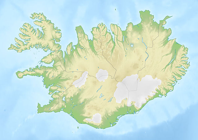
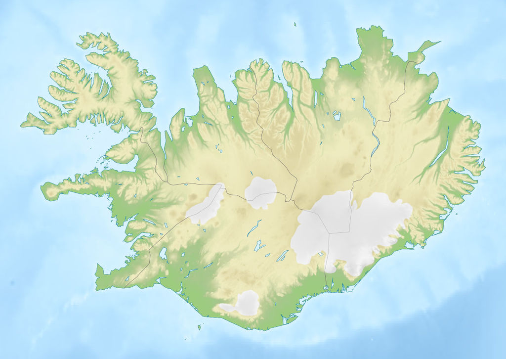
467:{{Information |Description= {{de|Positionskarte von ]}} Quadratische Plattkarte, N-S-Streckung 230 %. Geographische Begrenzung der Karte: * N: 66.8° N * S: 63.1° N * W: 25° W * O: 13° W {{en|Location m
1353:
575:
571:
527:
1328:
1513:
523:
632:
567:
762:}} Quadratische Plattkarte, N-S-Streckung 230 %. Geographische Begrenzung der Karte: * N: 66.8° N * S: 63.1° N * W: 25° W * O: 13° W {{en|Location map of
396:
1583:
1285:
776:
943:
578:"}},"text\/plain":{"en":{"P275":"GNU Free Documentation License, version 1.2 or later"}}}}": -->
1588:
150:
Quadratische
Plattkarte, N-S-Streckung 230 %. Geographische Begrenzung der Karte: * N: 66.8° N * S: 63.1° N * W: 25° W * O: 13° W
1602:
394:; with no Invariant Sections, no Front-Cover Texts, and no Back-Cover Texts. A copy of the license is included in the section entitled
163:
Equirectangular projection, N/S stretching 230 %. Geographic limits of the map: * N: 66.8° N * S: 63.1° N * W: 25° W * E: 13° W
618:
601:
553:
1613:
This file contains additional information, probably added from the digital camera or scanner used to create or digitize it.
215:
61:
1523:
347:
57:
53:
47:
106:
1568:
537:
1113:
386:
74:
642:
585:
512:
1098:
1093:
1073:
256:, which means that it has been digitally altered from its original version. The original can be viewed here:
211:
740:
735:
948:
751:
721:
1548:
436:
258:
201:
184:
309:
1616:
If the file has been modified from its original state, some details may not fully reflect the modified file.
775:
More than 100 pages use this file. The following list shows the first 100 pages that use this file only. A
391:
1649:
1558:
1543:
346:– If you remix, transform, or build upon the material, you must distribute your contributions under the
1343:
530:"}},"text\/plain":{"en":{"P6216":"copyrighted"}}}}": -->
1338:
270:
1123:
1228:
114:
1118:
1378:
1023:
476:
384:
Permission is granted to copy, distribute and/or modify this document under the terms of the
306:
1213:
998:
8:
1168:
1138:
1278:
1133:
1028:
873:
710:
705:
65:
42:
1553:
462:
453:
443:
205:
888:
818:
1038:
848:
281:
I, the copyright holder of this work, hereby publish it under the following licenses:
101:
1178:
1053:
1043:
502:
988:
973:
883:
828:
823:
1258:
1153:
1018:
1538:
1253:
1148:
1033:
1008:
963:
808:
1208:
248:
1273:
1268:
1243:
1158:
1143:
918:
813:
1203:
968:
1478:
913:
1483:
1308:
1263:
1233:
1223:
1218:
1103:
1068:
1063:
863:
1593:
1563:
1533:
1388:
1303:
783:
1498:
1403:
1248:
1193:
1163:
1128:
1083:
1003:
983:
652:
612:
595:
547:
237:
1664:
1048:
978:
798:
263:
908:
1188:
1088:
928:
1238:
1198:
1013:
1578:
1573:
953:
833:
759:
145:
1108:
858:
373:
159:
1173:
993:
923:
843:
678:
Click on a date/time to view the file as it appeared at that time.
1448:
1318:
898:
1183:
958:
933:
853:
838:
788:
763:
1408:
1528:
1503:
1458:
1433:
1058:
903:
893:
171:
1368:
938:
803:
793:
1418:
1373:
1078:
878:
868:
1428:
1423:
432:
This image is a derivative work of the following images:
89:
1393:
1468:
1438:
1413:
1383:
496:
Add a one-line explanation of what this file represents
1398:
1443:
773:
1493:
1453:
1363:
1294:
676:
619:
602:
Creative
Commons Attribution-ShareAlike 3.0 Unported
576:
572:
Creative
Commons Attribution-ShareAlike 3.0 Unported
390:, Version 1.2 or any later version published by the
113:
Commons is a freely licensed media file repository.
758:{{Information |Description={{de|Positionskarte von
79:(1,200 × 851 pixels, file size: 161 KB, MIME type:
1463:
1344:Módulu:Mapa de llocalización/datos/Islandia/usu
357:https://creativecommons.org/licenses/by-sa/3.0
94:
363:Creative Commons Attribution-Share Alike 3.0
287:
167:
131:
195:
178:
14:
1339:Módulu:Mapa de llocalización/datos/Islandia
323:– to copy, distribute and transmit the work
422:You may select the license of your choice.
1296:The following other wikis use this file:
944:Helgafell (Sveitarfélagið Stykkishólmur)
427:
125:
402:http://www.gnu.org/copyleft/fdl.html
310:Attribution-Share Alike 3.0 Unported
231:
669:
298:
293:
249:
247:
13:
1611:
1114:NATO Integrated Air Defense System
501:
495:
421:
284:
280:
152:
138:
126:
72:
1681:
1618:
1099:List of national parks of Iceland
1094:List of extreme points of Iceland
500:
439:licensed with Cc-by-sa-3.0, GFDL
486:
378:
377:
334:Under the following conditions:
305:This file is licensed under the
297:
292:
286:
262:
236:
93:
31:
21:
483:
153:
1291:
673:
482:
408:GNU Free Documentation License
397:GNU Free Documentation License
387:GNU Free Documentation License
139:
26:
1:
1379:Şablon:Yer xəritəsi İslandiya
1304:Vorlage:Positionskarte Island
437:File:Iceland_location_map.svg
36:
1499:Vorlog:Positionskarte Island
1074:Kárahnjúkar Hydropower Plant
949:Helgafell (Vestmannaeyjabær)
770:
508:Items portrayed in this file
7:
1650:Adobe Photoshop CS3 Windows
1608:
1490:Usage on bar.wikipedia.org
1475:Usage on ban.wikipedia.org
1335:Usage on ast.wikipedia.org
1300:Usage on als.wikipedia.org
10:
1686:
1520:Usage on be.wikipedia.org
1510:Usage on ba.wikipedia.org
1479:Taman Nasional Vatnajökull
1360:Usage on az.wikipedia.org
1350:Usage on av.wikipedia.org
1325:Usage on ar.wikipedia.org
1315:Usage on an.wikipedia.org
348:same or compatible license
128:
1656:File change date and time
1484:Taman Nasional Þingvellir
1354:Шаблон:БакІКарта Исландия
1309:Elliðaey (Vestmannaeyjar)
670:
16:
1329:قالب:خريطة مواقع آيسلندا
485:
465:1186x841 (279815 Bytes)
456:1186x841 (275750 Bytes)
446:1186x841 (277400 Bytes)
392:Free Software Foundation
314:
259:Iceland location map.svg
202:Iceland_location_map.svg
185:Iceland_location_map.svg
100:This is a file from the
41:
1514:Ҡалып:ПозКарта Исландия
1229:Vatnsfell Power Station
757:
727:
170:
104:. Information from its
1659:19:20, 20 October 2010
1119:No. 330 Squadron RNoAF
736:13:39, 20 October 2010
706:15:23, 20 October 2010
172:20 October 2010, 13:37
134:Iceland relief map.jpg
107:description page there
46:Size of this preview:
1630:Horizontal resolution
1449:Enniskorti (stansiya)
1124:Nyrðra-Vatnalautavatn
1024:Icelandic Coast Guard
461:2008-06-29T17:37:15Z
452:2008-06-30T19:38:28Z
442:2008-07-03T15:25:55Z
1389:Reykyanes yarımadası
1638:Vertical resolution
1404:Vatnsnes yarımadası
1139:Selfoss (waterfall)
428:Original upload log
329:– to adapt the work
144:Positionskarte von
52:Other resolutions:
1584:Скьяўльфандафльёўт
66:1,200 × 851 pixels
62:1,024 × 726 pixels
1673:
1672:
1603:more global usage
1292:Global file usage
1214:Tungnafellsjökull
1039:Kerling (Iceland)
999:Hvannadalshnjúkur
768:
586:copyright license
568:copyright license
494:
419:
418:
277:
276:
250:retouched picture
226:
225:
210:derivative work:
122:
121:
102:Wikimedia Commons
32:Global file usage
1677:
1619:
1369:Eyyafyatlayokudl
1319:Eyjafjallajökull
1134:Reykjavík Mosque
874:Eyjafjallajökull
824:Brennisteinsalda
748:
718:
680:
538:copyright status
524:copyright status
492:
415:
412:
409:
406:
403:
381:
380:
374:
370:
367:
364:
361:
358:
350:as the original.
307:Creative Commons
301:
300:
296:
295:
290:
289:
272:
266:
253:
251:
240:
232:
218:
173:
158:Location map of
157:
143:
135:
129:
118:
97:
96:
90:
84:
82:
69:
58:640 × 454 pixels
54:320 × 227 pixels
48:800 × 567 pixels
1685:
1684:
1680:
1679:
1678:
1676:
1675:
1674:
1607:
1589:Эйяф’ядлаёкюдль
1290:
1034:Katla (volcano)
889:Frostastaðavatn
769:
754:
746:
724:
716:
672:
671:
668:
667:
666:
665:
664:
663:
662:
661:
659:
658:20 October 2010
649:
648:
647:
645:
630:
629:
628:
627:
626:
625:
624:
623:
621:
610:
609:
608:
607:
606:
604:
592:
591:
590:
588:
565:
564:
563:
562:
561:
560:
559:
558:
556:
544:
543:
542:
540:
521:
520:
519:
518:
517:
515:
499:
498:
497:
430:
425:
424:
423:
413:
410:
407:
404:
401:
372:
371:
368:
365:
362:
359:
356:
355:
313:
302:
283:
282:
241:
227:
216:
162:
148:
133:
124:
123:
112:
111:
110:is shown below.
86:
80:
78:
71:
70:
51:
12:
11:
5:
1683:
1671:
1670:
1667:
1661:
1660:
1657:
1653:
1652:
1647:
1643:
1642:
1639:
1635:
1634:
1631:
1627:
1626:
1623:
1610:
1605:of this file.
1599:
1598:
1597:
1596:
1591:
1586:
1581:
1576:
1571:
1566:
1561:
1556:
1551:
1546:
1541:
1536:
1531:
1526:
1518:
1517:
1516:
1508:
1507:
1506:
1501:
1496:
1488:
1487:
1486:
1481:
1473:
1472:
1471:
1466:
1461:
1456:
1451:
1446:
1441:
1436:
1431:
1426:
1421:
1419:Melrakkasletta
1416:
1411:
1406:
1401:
1396:
1391:
1386:
1381:
1376:
1371:
1366:
1358:
1357:
1356:
1348:
1347:
1346:
1341:
1333:
1332:
1331:
1323:
1322:
1321:
1313:
1312:
1311:
1306:
1293:
1288:to this file.
1282:
1281:
1276:
1271:
1266:
1261:
1256:
1251:
1246:
1241:
1236:
1231:
1226:
1221:
1216:
1211:
1206:
1201:
1196:
1191:
1186:
1181:
1179:Sultartangalón
1176:
1171:
1169:Snæfellsjökull
1166:
1161:
1159:Skorradalsvatn
1156:
1151:
1146:
1144:Seljalandsfoss
1141:
1136:
1131:
1126:
1121:
1116:
1111:
1106:
1101:
1096:
1091:
1086:
1081:
1076:
1071:
1066:
1061:
1056:
1054:Kollóttadyngja
1051:
1046:
1044:Kerlingarfjöll
1041:
1036:
1031:
1026:
1021:
1016:
1011:
1006:
1001:
996:
991:
986:
981:
976:
971:
966:
961:
956:
951:
946:
941:
936:
931:
926:
921:
916:
911:
906:
901:
896:
891:
886:
881:
876:
871:
866:
861:
856:
851:
846:
841:
836:
831:
826:
821:
816:
811:
806:
801:
796:
791:
786:
779:is available.
772:
767:
766:
756:
752:
749:
743:
738:
733:
730:
729:
726:
722:
719:
713:
708:
703:
699:
698:
695:
692:
689:
686:
683:
675:
660:
657:
655:
654:
653:
651:
650:
646:
641:
639:
638:
637:
636:
634:
622:
617:
615:
614:
613:
611:
605:
600:
598:
597:
596:
594:
593:
589:
584:
582:
581:
580:
579:
577:
573:
569:
557:
552:
550:
549:
548:
546:
545:
541:
536:
534:
533:
532:
531:
529:
525:
516:
511:
509:
506:
505:
504:
503:
491:
490:
487:
484:
475:Uploaded with
472:
471:
470:
469:
459:
450:
429:
426:
420:
417:
416:
382:
354:
353:
352:
351:
341:
332:
331:
330:
324:
317:You are free:
304:
303:
285:
279:
278:
275:
274:
242:
235:
224:
223:
222:
221:
208:
197:
193:
192:
191:
190:
187:
180:
176:
175:
169:
165:
164:
136:
127:
120:
119:
98:
88:
87:
45:
40:
39:
34:
29:
24:
19:
9:
6:
4:
3:
2:
1682:
1668:
1666:
1663:
1662:
1658:
1655:
1654:
1651:
1648:
1646:Software used
1645:
1644:
1640:
1637:
1636:
1632:
1629:
1628:
1624:
1621:
1620:
1617:
1614:
1606:
1604:
1595:
1592:
1590:
1587:
1585:
1582:
1580:
1577:
1575:
1572:
1570:
1567:
1565:
1562:
1560:
1557:
1555:
1552:
1550:
1547:
1545:
1542:
1540:
1537:
1535:
1532:
1530:
1527:
1525:
1524:Тынгвадлаватн
1522:
1521:
1519:
1515:
1512:
1511:
1509:
1505:
1502:
1500:
1497:
1495:
1492:
1491:
1489:
1485:
1482:
1480:
1477:
1476:
1474:
1470:
1467:
1465:
1462:
1460:
1459:Qrimsey adası
1457:
1455:
1452:
1450:
1447:
1445:
1442:
1440:
1437:
1435:
1434:Hekla vulkanı
1432:
1430:
1427:
1425:
1422:
1420:
1417:
1415:
1412:
1410:
1407:
1405:
1402:
1400:
1397:
1395:
1392:
1390:
1387:
1385:
1382:
1380:
1377:
1375:
1372:
1370:
1367:
1365:
1362:
1361:
1359:
1355:
1352:
1351:
1349:
1345:
1342:
1340:
1337:
1336:
1334:
1330:
1327:
1326:
1324:
1320:
1317:
1316:
1314:
1310:
1307:
1305:
1302:
1301:
1299:
1298:
1297:
1289:
1287:
1280:
1277:
1275:
1272:
1270:
1267:
1265:
1262:
1260:
1259:Þingvallavatn
1257:
1255:
1252:
1250:
1247:
1245:
1242:
1240:
1237:
1235:
1232:
1230:
1227:
1225:
1222:
1220:
1217:
1215:
1212:
1210:
1207:
1205:
1202:
1200:
1197:
1195:
1192:
1190:
1187:
1185:
1182:
1180:
1177:
1175:
1172:
1170:
1167:
1165:
1162:
1160:
1157:
1155:
1154:Skjaldbreiður
1152:
1150:
1147:
1145:
1142:
1140:
1137:
1135:
1132:
1130:
1127:
1125:
1122:
1120:
1117:
1115:
1112:
1110:
1107:
1105:
1102:
1100:
1097:
1095:
1092:
1090:
1087:
1085:
1082:
1080:
1077:
1075:
1072:
1070:
1067:
1065:
1062:
1060:
1057:
1055:
1052:
1050:
1047:
1045:
1042:
1040:
1037:
1035:
1032:
1030:
1027:
1025:
1022:
1020:
1019:Hóp (Iceland)
1017:
1015:
1012:
1010:
1007:
1005:
1002:
1000:
997:
995:
992:
990:
987:
985:
982:
980:
977:
975:
972:
970:
967:
965:
962:
960:
957:
955:
952:
950:
947:
945:
942:
940:
937:
935:
932:
930:
927:
925:
922:
920:
917:
915:
912:
910:
907:
905:
902:
900:
897:
895:
892:
890:
887:
885:
882:
880:
877:
875:
872:
870:
867:
865:
862:
860:
857:
855:
852:
850:
847:
845:
842:
840:
837:
835:
832:
830:
827:
825:
822:
820:
817:
815:
812:
810:
807:
805:
802:
800:
797:
795:
792:
790:
787:
785:
782:
781:
780:
778:
765:
761:
755:
750:
744:
742:
739:
737:
734:
732:
731:
725:
720:
714:
712:
709:
707:
704:
701:
700:
696:
693:
690:
687:
684:
682:
681:
679:
656:
644:
640:
620:
616:
603:
599:
587:
583:
555:
551:
539:
535:
514:
510:
507:
488:
481:
480:
479:
478:
468:
464:
460:
458:
455:
451:
449:
445:
441:
440:
438:
435:
434:
433:
399:
398:
393:
389:
388:
383:
376:
375:
360:CC BY-SA 3.0
349:
345:
342:
339:
336:
335:
333:
328:
325:
322:
319:
318:
316:
315:
311:
308:
291:
273:
267:
265:
260:
255:
254:
252:
243:
239:
234:
233:
230:
229:
219:
213:
209:
207:
203:
200:
199:
198:
194:
188:
186:
183:
182:
181:
177:
166:
161:
156:
151:
147:
142:
137:
130:
116:
109:
108:
103:
99:
92:
91:
85:
76:
75:Original file
67:
63:
59:
55:
49:
44:
38:
35:
33:
30:
28:
25:
23:
20:
18:
15:
1615:
1612:
1600:
1569:Інгальфсф’ял
1429:Snayfedlsnes
1424:Tryodlaskaqi
1295:
1283:
1209:Trölladyngja
849:Eiríksjökull
784:Aldeyjarfoss
774:
745:1,000 × 709
715:1,200 × 851
677:
674:File history
477:derivativeFX
474:
473:
466:
463:NordNordWest
457:
454:NordNordWest
447:
444:NordNordWest
431:
395:
385:
343:
337:
326:
320:
269:
257:
246:
245:
228:
206:NordNordWest
154:
149:
140:
115:You can help
105:
73:
22:File history
1665:Color space
1622:Orientation
1549:Лаўнгёкудль
1394:Kleyvarvatn
1279:Þórólfsfell
1204:Torfajökull
1049:Kleifarvatn
1029:Jökulsárlón
989:Hvalfjörður
979:Hraunfossar
974:Hlíðarfjall
969:Hjálparfoss
884:Fjallsárlón
829:Bárðarbunga
799:Barnafossar
554:copyrighted
528:copyrighted
344:share alike
338:attribution
244:This is a
132:Description
1641:91.059 dpi
1633:91.059 dpi
1559:Лейгарватн
1544:Таўрысватн
1469:Okyyokyudl
1439:Eyya-fiord
1414:Bulandsnes
1384:Tinqvedlir
1286:more links
1264:Þingvellir
1254:Öxarárfoss
1234:Vífilsfell
1224:Vatnafjöll
1219:Urriðafoss
1189:Svartifoss
1149:Sigöldulón
1104:Látrabjarg
1089:Laugarvatn
1069:Kvíslavatn
1064:Kverkfjöll
1009:Hvítárvatn
964:Herðubreið
929:Haukadalur
864:Elliðavatn
819:Breiðárlón
809:Bláhnjúkur
771:File usage
691:Dimensions
81:image/jpeg
27:File usage
1409:Xoup gölü
1399:Launqanes
1374:Qrimsvötn
1274:Þórisvatn
1269:Þjófafoss
1249:Öskjuvatn
1244:Ófærufoss
1194:Svínavatn
1164:Skógafoss
1129:Reykjavík
1084:Langisjór
1004:Hvítavatn
984:Hreðavatn
954:Hengifoss
919:Grímsvötn
834:Dettifoss
814:Blöndulón
777:full list
688:Thumbnail
685:Date/Time
643:inception
633:inception
448:corrected
155:English:
141:Deutsch:
1609:Metadata
1444:Stoksnes
1174:Strokkur
994:Hvalvatn
924:Gullfoss
914:Grænalón
909:Goðafoss
844:Dynjandi
753:Виктор В
747:(124 KB)
723:Виктор В
717:(161 KB)
489:Captions
327:to remix
321:to share
312:license.
212:Виктор В
37:Metadata
1554:Апаватн
1504:Aðalvík
1454:Youlnir
1364:Surtsey
1239:Álafoss
1199:Tjörnin
1184:Surtsey
1014:Háifoss
959:Hengill
934:Heimaey
854:Eldfell
839:Drangey
789:Apavatn
764:Iceland
702:current
697:Comment
513:depicts
493:English
261::
160:Iceland
77:
1625:Normal
1539:Міватн
1494:Island
1109:Mývatn
1059:Krafla
904:Glymur
894:Geysir
859:Eldgjá
760:Island
271:
196:Author
189:SRTM30
179:Source
146:Island
1601:View
1594:Катла
1564:Керыз
1534:Гекла
1464:Eldey
1284:View
939:Hekla
899:Gjáin
804:Baula
794:Askja
174:(UTC)
1669:sRGB
1579:Хоўп
1574:Лакі
1079:Laki
879:Faxi
869:Esja
694:User
414:true
411:true
405:GFDL
369:true
366:true
217:talk
168:Date
17:File
1529:Сог
268:.
204::
64:|
60:|
56:|
50:.
728:м
400:.
220:)
214:(
117:.
83:)
68:.
Text is available under the Creative Commons Attribution-ShareAlike License. Additional terms may apply.
