677:"}},"text\/plain":{"en":{"":"coordinates of the point of view"}}},"{\"value\":{\"latitude\":50.717406,\"longitude\":-1.87577,\"altitude\":null,\"precision\":1.0e-6,\"globe\":\"http:\\\/\\\/www.wikidata.org\\\/entity\\\/Q2\"},\"type\":\"globecoordinate\"}":{"text\/html":{"en":{"P1259":"50\u00b043'2.662"N, 1\u00b052'32.772"W"}},"text\/plain":{"en":{"P1259":"50\u00b043'2.662\"N, 1\u00b052'32.772\"W"}}},"{\"value\":{\"entity-type\":\"property\",\"numeric-id\":7787,\"id\":\"P7787\"},\"type\":\"wikibase-entityid\"}":{"text\/html":{"en":{"":"
902:"}},"text\/plain":{"en":{"":"coordinates of depicted place"}}},"{\"value\":{\"latitude\":50.717406,\"longitude\":-1.87577,\"altitude\":null,\"precision\":1.0e-6,\"globe\":\"http:\\\/\\\/www.wikidata.org\\\/entity\\\/Q2\"},\"type\":\"globecoordinate\"}":{"text\/html":{"en":{"P9149":"50\u00b043'2.662"N, 1\u00b052'32.772"W"}},"text\/plain":{"en":{"P9149":"50\u00b043'2.662\"N, 1\u00b052'32.772\"W"}}},"{\"value\":{\"entity-type\":\"property\",\"numeric-id\":7787,\"id\":\"P7787\"},\"type\":\"wikibase-entityid\"}":{"text\/html":{"en":{"":"
1143:"}},"text\/plain":{"en":{"":"checksum"}}},"{\"value\":\"f523b94cc35d249aa8e0dd31bedf206c455454b3\",\"type\":\"string\"}":{"text\/html":{"en":{"P4092":"f523b94cc35d249aa8e0dd31bedf206c455454b3"}},"text\/plain":{"en":{"P4092":"f523b94cc35d249aa8e0dd31bedf206c455454b3"}}},"{\"value\":{\"entity-type\":\"property\",\"numeric-id\":459,\"id\":\"P459\"},\"type\":\"wikibase-entityid\"}":{"text\/html":{"en":{"":"
486:"}},"text\/plain":{"en":{"":"author name string"}}},"{\"value\":\"Mike Faherty\",\"type\":\"string\"}":{"text\/html":{"en":{"P2093":"Mike Faherty"}},"text\/plain":{"en":{"P2093":"Mike Faherty"}}},"{\"value\":{\"entity-type\":\"property\",\"numeric-id\":3831,\"id\":\"P3831\"},\"type\":\"wikibase-entityid\"}":{"text\/html":{"en":{"":"
745:"}},"text\/plain":{"en":{"":"inception"}}},"{\"value\":{\"time\":\"+2008-11-22T00:00:00Z\",\"timezone\":0,\"before\":0,\"after\":0,\"precision\":11,\"calendarmodel\":\"http:\\\/\\\/www.wikidata.org\\\/entity\\\/Q1985727\"},\"type\":\"time\"}":{"text\/html":{"en":{"P571":"22 November 2008"}},"text\/plain":{"en":{"P571":"22 November 2008"}}}}": -->
779:
279:
229:
1139:
221:
293:
243:
314:
352:
357:
67:
787:"}},"text\/plain":{"en":{"P7482":"file available on the internet"}}},"{\"value\":{\"entity-type\":\"property\",\"numeric-id\":7384,\"id\":\"P7384\"},\"type\":\"wikibase-entityid\"}":{"text\/html":{"en":{"":"
490:"}},"text\/plain":{"en":{"":"object of statement has role"}}},"{\"value\":{\"entity-type\":\"item\",\"numeric-id\":33231,\"id\":\"Q33231\"},\"type\":\"wikibase-entityid\"}":{"text\/html":{"en":{"P3831":"
803:"}},"text\/plain":{"en":{"P137":"Geograph Britain and Ireland"}}},"{\"value\":{\"entity-type\":\"property\",\"numeric-id\":973,\"id\":\"P973\"},\"type\":\"wikibase-entityid\"}":{"text\/html":{"en":{"":"
1147:"}},"text\/plain":{"en":{"":"determination method"}}},"{\"value\":{\"entity-type\":\"item\",\"numeric-id\":13414952,\"id\":\"Q13414952\"},\"type\":\"wikibase-entityid\"}":{"text\/html":{"en":{"P459":"
1105:"}},"text\/plain":{"en":{"":"media type"}}},"{\"value\":\"image\\\/jpeg\",\"type\":\"string\"}":{"text\/html":{"en":{"P1163":"image\/jpeg"}},"text\/plain":{"en":{"P1163":"image\/jpeg"}}}}": -->
1248:
633:"}},"text\/plain":{"en":{"":"copyright license"}}},"{\"value\":{\"entity-type\":\"item\",\"numeric-id\":19068220,\"id\":\"Q19068220\"},\"type\":\"wikibase-entityid\"}":{"text\/html":{"en":{"P275":"
589:"}},"text\/plain":{"en":{"":"copyright status"}}},"{\"value\":{\"entity-type\":\"item\",\"numeric-id\":50423863,\"id\":\"Q50423863\"},\"type\":\"wikibase-entityid\"}":{"text\/html":{"en":{"P6216":"
783:"}},"text\/plain":{"en":{"":"source of file"}}},"{\"value\":{\"entity-type\":\"item\",\"numeric-id\":74228490,\"id\":\"Q74228490\"},\"type\":\"wikibase-entityid\"}":{"text\/html":{"en":{"P7482":"
970:"}},"text\/plain":{"en":{"":"data size"}}},"{\"value\":{\"amount\":\"+105510\",\"unit\":\"http:\\\/\\\/www.wikidata.org\\\/entity\\\/Q8799\"},\"type\":\"quantity\"}":{"text\/html":{"en":{"P3575":"105,510
494:"}},"text\/plain":{"en":{"P3831":"photographer"}}},"{\"value\":{\"entity-type\":\"property\",\"numeric-id\":2699,\"id\":\"P2699\"},\"type\":\"wikibase-entityid\"}":{"text\/html":{"en":{"":"
1015:"}},"text\/plain":{"en":{"":"height"}}},"{\"value\":{\"amount\":\"+480\",\"unit\":\"http:\\\/\\\/www.wikidata.org\\\/entity\\\/Q355198\"},\"type\":\"quantity\"}":{"text\/html":{"en":{"P2048":"480
799:"}},"text\/plain":{"en":{"":"operator"}}},"{\"value\":{\"entity-type\":\"item\",\"numeric-id\":1503119,\"id\":\"Q1503119\"},\"type\":\"wikibase-entityid\"}":{"text\/html":{"en":{"P137":"
1060:"}},"text\/plain":{"en":{"":"width"}}},"{\"value\":{\"amount\":\"+640\",\"unit\":\"http:\\\/\\\/www.wikidata.org\\\/entity\\\/Q355198\"},\"type\":\"quantity\"}":{"text\/html":{"en":{"P2049":"640
906:"}},"text\/plain":{"en":{"":"heading"}}},"{\"value\":{\"amount\":\"+0\",\"unit\":\"http:\\\/\\\/www.wikidata.org\\\/entity\\\/Q28390\"},\"type\":\"quantity\"}":{"text\/html":{"en":{"P7787":"0
795:"}},"text\/plain":{"en":{"P7384":"1055444"}}},"{\"value\":{\"entity-type\":\"property\",\"numeric-id\":137,\"id\":\"P137\"},\"type\":\"wikibase-entityid\"}":{"text\/html":{"en":{"":"
681:"}},"text\/plain":{"en":{"":"heading"}}},"{\"value\":{\"amount\":\"+0\",\"unit\":\"http:\\\/\\\/www.wikidata.org\\\/entity\\\/Q28390\"},\"type\":\"quantity\"}":{"text\/html":{"en":{"P7787":"0
482:"}},"text\/plain":{"en":{"":"creator"}}},"{\"value\":{\"entity-type\":\"property\",\"numeric-id\":2093,\"id\":\"P2093\"},\"type\":\"wikibase-entityid\"}":{"text\/html":{"en":{"":"
1101:
498:"}},"text\/plain":{"en":{"":"URL"}}},"{\"value\":\"https:\\\/\\\/www.geograph.org.uk\\\/profile\\\/30470\",\"type\":\"string\"}":{"text\/html":{"en":{"P2699":"
262:
791:"}},"text\/plain":{"en":{"":"geograph.org.uk image ID"}}},"{\"value\":\"1055444\",\"type\":\"string\"}":{"text\/html":{"en":{"P7384":"
212:
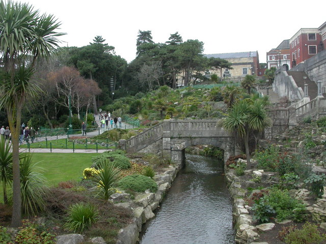
1265:== {{int:filedesc}} == {{Information |description={{en|1=Lower Gardens, Bournemouth Laid out in the 1870s along the Bourne Stream; here looking north to a footbridge to the Pavilion, and, behind, the large rockery, which was constructed in 1930.
http://w
404:– You must give appropriate credit, provide a link to the license, and indicate if changes were made. You may do so in any reasonable manner, but not in any way that suggests the licensor endorses you or your use.
276:
226:
78:
46:
121:
Lower
Gardens, Bournemouth Laid out in the 1870s along the Bourne Stream; here looking north to a footbridge to the Pavilion, and, behind, the large rockery, which was constructed in 1930.
792:
1148:
784:
634:
590:
800:
491:
1140:
1102:
1057:
1012:
967:
903:
899:
788:
780:
678:
674:
586:
495:
487:
483:
808:
499:
1144:
804:
796:
742:
630:
479:
122:
1258:
637:"}},"text\/plain":{"en":{"P275":"Creative Commons Attribution-ShareAlike 2.0 Generic"}}}}": -->
502:"}},"text\/plain":{"en":{"P2699":"https:\/\/www.geograph.org.uk\/profile\/30470"}}}}": -->
811:"}},"text\/plain":{"en":{"P973":"https:\/\/www.geograph.org.uk\/photo\/1055444"}}}}": -->
1192:
834:
660:
616:
286:
236:
123:
http://www.bournemouth.gov.uk/Visitors/Parks_Gardens_Countryside/upper_central_lower_gardens/Walk_through_the_Lower_Gardens.asp
1247:
1242:
869:
37:
321:
1290:
This file contains additional information, probably added from the digital camera or scanner used to create or digitize it.
411:
556:
1158:
1112:
1071:
1026:
981:
944:
917:
847:
818:
719:
692:
600:
564:
549:
536:
1185:
877:
862:
752:
644:
509:
468:
367:
1293:
If the file has been modified from its original state, some details may not fully reflect the modified file.
410:– If you remix, transform, or build upon the material, you must distribute your contributions under the
328:
on the
Geograph website for the photographer's contact details. The copyright on this image is owned by
974:"}},"text\/plain":{"en":{"P3575":"105,510 byte"}}}}": -->
593:"}},"text\/plain":{"en":{"P6216":"copyrighted"}}}}": -->
1064:"}},"text\/plain":{"en":{"P2049":"640 pixel"}}}}": -->
1019:"}},"text\/plain":{"en":{"P2048":"480 pixel"}}}}": -->
910:"}},"text\/plain":{"en":{"P7787":"0 degree"}}}}": -->
685:"}},"text\/plain":{"en":{"P7787":"0 degree"}}}}": -->
86:
181:
1151:"}},"text\/plain":{"en":{"P459":"SHA-1"}}}}": -->
884:
854:
571:
364:
165:
8:
308:
292:
242:
333:
73:
458:
154:
144:
1168:
1122:
1081:
1036:
991:
927:
828:
762:
702:
654:
610:
519:
1279:
313:
325:
1215:
Click on a date/time to view the file as it appeared at that time.
278:
228:
263:
50° 43′ 02.66″ N, 1° 52′ 32.8″ W
213:
50° 43′ 02.66″ N, 1° 52′ 32.8″ W
111:
Lower
Gardens, Bournemouth - geograph.org.uk - 1055444.jpg
47:
Lower_Gardens,_Bournemouth_-_geograph.org.uk_-_1055444.jpg
133:
61:
452:
Add a one-line explanation of what this file represents
1273:
1213:
85:
Commons is a freely licensed media file repository.
661:
Creative
Commons Attribution-ShareAlike 2.0 Generic
635:
Creative
Commons Attribution-ShareAlike 2.0 Generic
51:(640 × 480 pixels, file size: 103 KB, MIME type:
421:https://creativecommons.org/licenses/by-sa/2.0
66:
809:https:\/\/www.geograph.org.uk\/photo\/1055444
500:https:\/\/www.geograph.org.uk\/profile\/30470
427:Creative Commons Attribution-Share Alike 2.0
345:
129:
108:
150:
139:
14:
1061:
1016:
971:
907:
682:
387:– to copy, distribute and transmit the work
885:https://www.geograph.org.uk/photo/1055444
572:https://www.geograph.org.uk/profile/30470
1174:f523b94cc35d249aa8e0dd31bedf206c455454b3
285:View this and other nearby images on:
235:View this and other nearby images on:
188:
97:
332:and is licensed for reuse under the
253:
203:
1275:The following page uses this file:
1206:
368:Attribution-Share Alike 2.0 Generic
356:
351:
336:Attribution-ShareAlike 2.0 license.
13:
1288:
457:
451:
342:
319:
115:
98:
44:
1314:
1295:
456:
693:coordinates of the point of view
675:coordinates of the point of view
442:
398:Under the following conditions:
363:This file is licensed under the
355:
350:
344:
312:
291:
277:
269:
241:
227:
219:
65:
21:
439:
116:
41:No higher resolution available.
1210:
835:file available on the internet
785:file available on the internet
438:
320:This image was taken from the
26:
1:
918:coordinates of depicted place
900:coordinates of depicted place
31:
1270:
933:50°43'2.662"N, 1°52'32.772"W
870:Geograph Britain and Ireland
801:Geograph Britain and Ireland
708:50°43'2.662"N, 1°52'32.772"W
550:object of statement has role
488:object of statement has role
464:Items portrayed in this file
304:
7:
1285:
10:
1319:
412:same or compatible license
268:
218:
196:Lower Gardens, Bournemouth
177:Lower Gardens, Bournemouth
105:
100:
1207:
194:Mike Faherty /
175:Mike Faherty /
16:
848:geograph.org.uk image ID
789:geograph.org.uk image ID
441:
378:
72:This is a file from the
36:
1264:
1243:01:07, 24 February 2011
166:required by the license
132:
76:. Information from its
326:this photograph's page
297:50.717406; -1.875770
247:50.717406; -1.875770
79:description page there
1186:determination method
1145:determination method
393:– to adapt the work
537:author name string
484:author name string
1306:
1305:
1268:
1063:
1018:
973:
909:
684:
645:copyright license
631:copyright license
450:
341:
340:
324:collection. See
302:
301:
252:
251:
201:
200:
169:
94:
93:
74:Wikimedia Commons
1310:
1296:
1255:
1217:
1195:
1190:
1090:
1045:
1000:
955:
954:
949:
887:
882:
878:described at URL
872:
867:
857:
852:
805:described at URL
768:22 November 2008
730:
729:
724:
601:copyright status
587:copyright status
574:
569:
559:
554:
544:
541:
448:
434:
431:
428:
425:
422:
414:as the original.
376:
365:Creative Commons
359:
358:
354:
353:
348:
347:
334:Creative Commons
322:Geograph project
316:
309:
298:
295:
281:
280:
274:
273:
272:
266:
265:
254:
248:
245:
231:
230:
224:
223:
222:
216:
215:
204:
163:
135:
134:22 November 2008
120:
112:
106:
90:
69:
68:
62:
56:
54:
1318:
1317:
1313:
1312:
1311:
1309:
1308:
1307:
1284:
1269:
1261:
1253:
1209:
1208:
1205:
1204:
1203:
1202:
1201:
1200:
1199:
1198:
1197:
1196:
1191:
1188:
1179:
1178:
1177:
1175:
1165:
1164:
1163:
1161:
1138:
1137:
1136:
1135:
1134:
1133:
1132:
1131:
1129:
1119:
1118:
1117:
1115:
1100:
1099:
1098:
1097:
1096:
1095:
1094:
1093:
1091:
1088:
1078:
1077:
1076:
1074:
1055:
1054:
1053:
1052:
1051:
1050:
1049:
1048:
1046:
1043:
1033:
1032:
1031:
1029:
1010:
1009:
1008:
1007:
1006:
1005:
1004:
1003:
1001:
998:
988:
987:
986:
984:
965:
964:
963:
962:
961:
960:
959:
958:
957:
956:
952:
950:
947:
938:
937:
936:
934:
924:
923:
922:
920:
897:
896:
895:
894:
893:
892:
891:
890:
889:
888:
883:
880:
874:
873:
868:
865:
859:
858:
853:
850:
841:
840:
839:
837:
825:
824:
823:
821:
778:
777:
776:
775:
774:
773:
772:
771:
769:
759:
758:
757:
755:
740:
739:
738:
737:
736:
735:
734:
733:
732:
731:
727:
725:
722:
713:
712:
711:
709:
699:
698:
697:
695:
672:
671:
670:
669:
668:
667:
666:
665:
663:
651:
650:
649:
647:
628:
627:
626:
625:
624:
623:
622:
621:
619:
607:
606:
605:
603:
584:
583:
582:
581:
580:
579:
578:
577:
576:
575:
570:
567:
561:
560:
555:
552:
546:
545:
542:
539:
530:
529:
528:
526:
516:
515:
514:
512:
477:
476:
475:
474:
473:
471:
455:
454:
453:
436:
435:
432:
429:
426:
423:
420:
419:
377:
374:
371:
360:
337:
307:
296:
270:
261:
260:
257:Object location
246:
220:
211:
210:
207:Camera location
202:
191:
184:
172:
145:geograph.org.uk
125:
110:
103:
96:
95:
84:
83:
82:is shown below.
58:
52:
50:
43:
42:
12:
11:
5:
1316:
1304:
1303:
1300:
1287:
1283:
1282:
1272:
1267:
1266:
1263:
1259:
1256:
1250:
1245:
1240:
1236:
1235:
1232:
1229:
1226:
1223:
1220:
1212:
1184:
1183:
1182:
1181:
1180:
1176:
1173:
1171:
1170:
1169:
1167:
1166:
1162:
1157:
1155:
1154:
1153:
1152:
1150:
1146:
1142:
1130:
1127:
1125:
1124:
1123:
1121:
1120:
1116:
1111:
1109:
1108:
1107:
1106:
1104:
1092:
1086:
1084:
1083:
1082:
1080:
1079:
1075:
1070:
1068:
1067:
1066:
1065:
1059:
1047:
1041:
1039:
1038:
1037:
1035:
1034:
1030:
1025:
1023:
1022:
1021:
1020:
1014:
1002:
996:
994:
993:
992:
990:
989:
985:
980:
978:
977:
976:
975:
969:
943:
942:
941:
940:
939:
935:
932:
930:
929:
928:
926:
925:
921:
916:
914:
913:
912:
911:
905:
901:
876:
875:
861:
860:
846:
845:
844:
843:
842:
838:
833:
831:
830:
829:
827:
826:
822:
819:source of file
817:
815:
814:
813:
812:
810:
806:
802:
798:
794:
790:
786:
782:
781:source of file
770:
767:
765:
764:
763:
761:
760:
756:
751:
749:
748:
747:
746:
744:
718:
717:
716:
715:
714:
710:
707:
705:
704:
703:
701:
700:
696:
691:
689:
688:
687:
686:
680:
676:
664:
659:
657:
656:
655:
653:
652:
648:
643:
641:
640:
639:
638:
636:
632:
620:
615:
613:
612:
611:
609:
608:
604:
599:
597:
596:
595:
594:
592:
588:
563:
562:
548:
547:
535:
534:
533:
532:
531:
527:
524:
522:
521:
520:
518:
517:
513:
508:
506:
505:
504:
503:
501:
497:
493:
489:
485:
481:
472:
467:
465:
462:
461:
460:
459:
447:
446:
443:
440:
418:
417:
416:
415:
405:
396:
395:
394:
388:
381:You are free:
372:
362:
361:
343:
339:
338:
317:
306:
303:
300:
299:
289:
283:
258:
250:
249:
239:
233:
208:
199:
198:
192:
189:
186:
185:
180:
173:
170:
158:
157:
152:
148:
147:
141:
137:
136:
131:
127:
126:
113:
104:
102:
99:
92:
91:
70:
60:
59:
40:
35:
34:
29:
24:
19:
9:
6:
4:
3:
2:
1315:
1301:
1298:
1297:
1294:
1291:
1281:
1278:
1277:
1276:
1262:
1257:
1251:
1249:
1246:
1244:
1241:
1238:
1237:
1233:
1230:
1227:
1224:
1221:
1219:
1218:
1216:
1194:
1187:
1172:
1160:
1156:
1126:
1114:
1110:
1085:
1073:
1069:
1040:
1028:
1024:
995:
983:
979:
946:
931:
919:
915:
886:
879:
871:
864:
856:
849:
836:
832:
820:
816:
766:
754:
750:
721:
706:
694:
690:
662:
658:
646:
642:
618:
614:
602:
598:
573:
566:
558:
551:
538:
523:
511:
507:
470:
466:
463:
444:
437:
424:CC BY-SA 2.0
413:
409:
406:
403:
400:
399:
397:
392:
389:
386:
383:
382:
380:
379:
373:Attribution:
369:
366:
349:
335:
331:
327:
323:
318:
315:
311:
310:
294:
290:
288:
287:OpenStreetMap
284:
282:
264:
259:
256:
255:
244:
240:
238:
237:OpenStreetMap
234:
232:
214:
209:
206:
205:
197:
193:
187:
183:
179: /
178:
174:
167:
162:
160:
159:
156:
153:
149:
146:
142:
138:
128:
124:
119:
114:
107:
88:
81:
80:
75:
71:
64:
63:
57:
48:
39:
33:
30:
28:
25:
23:
20:
18:
15:
1292:
1289:
1274:
1214:
1211:File history
557:photographer
543:Mike Faherty
492:photographer
407:
401:
390:
384:
375:Mike Faherty
330:Mike Faherty
329:
267:
217:
195:
182:CC BY-SA 2.0
176:
155:Mike Faherty
117:
87:You can help
77:
45:
22:File history
1280:Bournemouth
1260:GeographBot
617:copyrighted
591:copyrighted
408:share alike
402:attribution
161:Attribution
109:Description
1299:_error
1271:File usage
1252:640 × 480
1228:Dimensions
1128:image/jpeg
1113:media type
1103:media type
525:some value
53:image/jpeg
27:File usage
1225:Thumbnail
1222:Date/Time
982:data size
968:data size
753:inception
743:inception
305:Licensing
190:InfoField
171:InfoField
118:English:
1286:Metadata
1254:(103 KB)
1159:checksum
1141:checksum
997:105,510
863:operator
797:operator
445:Captions
391:to remix
385:to share
370:license.
32:Metadata
1239:current
1234:Comment
945:heading
904:heading
855:1055444
793:1055444
720:heading
679:heading
510:creator
480:creator
469:depicts
449:English
101:Summary
49:
1027:height
1013:height
953:degree
908:degree
728:degree
683:degree
275:
225:
151:Author
140:Source
1193:SHA-1
1149:SHA-1
1089:pixel
1072:width
1062:pixel
1058:width
1044:pixel
1017:pixel
143:From
1231:User
1087:640
1042:480
999:byte
972:byte
433:true
430:true
130:Date
17:File
565:URL
496:URL
1189::
951:0
948::
881::
866::
851::
726:0
723::
568::
553::
540::
1302:0
168:)
164:(
89:.
55:)
Text is available under the Creative Commons Attribution-ShareAlike License. Additional terms may apply.
_heading:0.00&language=en)
_heading:0.00&language=en)
