55:
501:
532:
106:
43:
444:
271:
to the east and the
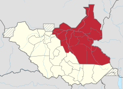
Republic of Sudan to the north. The South Sudanese region of Bahr el Ghazal lies to the west and the region of Equatoria lies to the South of Greater Upper Nile.
477:
68:
510:
248:
470:
54:
448:
557:
463:
42:
562:
552:
310:
381:
303:
361:
202:
486:
280:
33:
356:
346:
8:
500:
179:
297:
317:
Between
October 2015 and February 2020, the region consisted of the following states:
455:
193:
546:
366:
341:
292:
287:
83:
70:
376:
371:
351:
336:
225:
531:
490:
321:
256:
229:
213:
111:
393:
331:
326:
221:
217:
515:
252:
170:
418:
268:
247:
on 9 July 2011 along with its fellow
Southern Sudanese regions of
129:
443:
232:
175:
220:(it is its lowest portion in South Sudan), a tributary of the
244:
419:"SUDAN: land conflicts threaten peace in Upper Nile State"
485:
207:
279:The Greater Upper Nile consists of the following
544:
243:The Greater Upper Nile region seceded from the
471:
274:
478:
464:
144:236,208 km (91,200 sq mi)
413:
411:
409:
255:. The three regions now constitute the
545:
459:
406:
197:
13:
14:
574:
437:
530:
499:
442:
104:
53:
41:
267:The Greater Upper Nile borders
212:) is a region of northeastern
1:
399:
262:
7:
387:
208:
10:
579:
311:Ruweng Administrative Area
238:
527:
506:
497:
421:. Afronline. 23 June 2011
382:Northern Upper Nile State
304:Pibor Administrative Area
169:
161:
153:
148:
140:
135:
125:
117:
99:
64:
52:
40:
31:
21:
362:Central Upper Nile State
275:Administrative divisions
59:Location in South Sudan.
47:South Sudan Lucy digger.
25:
257:Republic of South Sudan
558:Regions of South Sudan
216:. It is named for the
453:at Wikimedia Commons
165:17/km (45/sq mi)
16:Region in South Sudan
357:Southern Liech State
347:Northern Liech State
162: • Density
80: /
563:Historical regions
553:Greater Upper Nile
521:Greater Upper Nile
487:Historical regions
450:Greater Upper Nile
190:Greater Upper Nile
154: • Total
141: • Total
121:Greater Upper Nile
23:Greater Upper Nile
540:
539:
447:Media related to
245:Republic of Sudan
206:
198:منطقة أعالي النيل
186:
185:
84:10.500°N 32.500°E
26:منطقة أعالي النيل
570:
535:
534:
503:
480:
473:
466:
457:
456:
446:
431:
430:
428:
426:
415:
211:
201:
199:
110:
108:
107:
95:
94:
92:
91:
90:
85:
81:
78:
77:
76:
73:
57:
45:
19:
18:
578:
577:
573:
572:
571:
569:
568:
567:
543:
542:
541:
536:
529:
525:
504:
493:
484:
440:
435:
434:
424:
422:
417:
416:
407:
402:
390:
277:
265:
241:
105:
103:
88:
86:
82:
79:
74:
71:
69:
67:
66:
60:
48:
36:
27:
24:
17:
12:
11:
5:
576:
566:
565:
560:
555:
538:
537:
528:
526:
524:
523:
518:
513:
511:Bahr el Ghazal
507:
505:
498:
495:
494:
483:
482:
475:
468:
460:
439:
438:External links
436:
433:
432:
404:
403:
401:
398:
397:
396:
389:
386:
385:
384:
379:
374:
369:
364:
359:
354:
349:
344:
339:
334:
329:
324:
315:
314:
307:
300:
295:
290:
276:
273:
264:
261:
249:Bahr el Ghazal
240:
237:
184:
183:
173:
167:
166:
163:
159:
158:
155:
151:
150:
146:
145:
142:
138:
137:
133:
132:
127:
123:
122:
119:
115:
114:
101:
97:
96:
89:10.500; 32.500
62:
61:
58:
50:
49:
46:
38:
37:
32:
29:
28:
22:
15:
9:
6:
4:
3:
2:
575:
564:
561:
559:
556:
554:
551:
550:
548:
533:
522:
519:
517:
514:
512:
509:
508:
502:
496:
492:
488:
481:
476:
474:
469:
467:
462:
461:
458:
454:
452:
451:
445:
420:
414:
412:
410:
405:
395:
392:
391:
383:
380:
378:
375:
373:
370:
368:
367:Fashoda State
365:
363:
360:
358:
355:
353:
350:
348:
345:
343:
342:Jonglei State
340:
338:
335:
333:
330:
328:
325:
323:
320:
319:
318:
313:
312:
308:
306:
305:
301:
299:
296:
294:
291:
289:
288:Jonglei State
286:
285:
284:
282:
272:
270:
260:
258:
254:
250:
246:
236:
234:
231:
227:
223:
219:
215:
210:
204:
195:
191:
181:
177:
174:
172:
168:
164:
160:
156:
152:
147:
143:
139:
134:
131:
128:
124:
120:
116:
113:
102:
98:
93:
65:Coordinates:
63:
56:
51:
44:
39:
35:
30:
20:
520:
449:
441:
423:. Retrieved
377:Maiwut State
372:Latjor State
352:Ruweng State
337:Fangak State
316:
309:
302:
278:
266:
242:
209:A'Ali An Nil
189:
187:
491:South Sudan
322:Akobo State
214:South Sudan
112:South Sudan
87: /
547:Categories
400:References
394:White Nile
332:Boma State
327:Bieh State
298:Upper Nile
222:Nile River
218:White Nile
149:Population
516:Equatoria
263:Geography
253:Equatoria
203:romanized
171:Time zone
157:4,119,700
388:See also
269:Ethiopia
239:History
205::
130:Malakal
126:Capital
100:Country
75:32°30′E
72:10°30′N
425:8 July
281:states
233:Africa
194:Arabic
118:Region
109:
34:Region
293:Unity
226:North
176:UTC+2
427:2011
251:and
230:East
228:and
188:The
136:Area
489:of
224:in
180:CAT
549::
408:^
283::
259:.
235:.
200:,
196::
479:e
472:t
465:v
429:.
192:(
182:)
178:(
Text is available under the Creative Commons Attribution-ShareAlike License. Additional terms may apply.

