318:
24:
114:
170:
visited the island on 7 July 1754. The northern coastline of Groais Island has high cliffs rising over 100 metres from the ocean. Although the ocean is mostly ice-covered in the region from
January to April, the prevailing westerly winds often create open leads of water around the island.
59:, is a useful starting point for translations, but translators must revise errors as necessary and confirm that the translation is accurate, rather than simply copy-pasting machine-translated text into the English Knowledge.
163:, Groix is written as Groe (pronounced ). The name might come from the Breton word groa, meaning "pebble ridge," which in turn is derived from the Celtic root graua, also the origin of the French word "gravier" (gravel).
378:
359:
383:
62:
Do not translate text that appears unreliable or low-quality. If possible, verify the text with references provided in the foreign-language article.
262:
188:
352:
279:
267:
345:
240:
183:
209:
70:
83:
Content in this edit is translated from the existing Dutch
Knowledge article at ]; see its history for attribution.
129:
325:
137:
78:
133:
99:
8:
333:
92:
74:
317:
174:
Groais Island is important for birds during both the breeding and wintering season.
36:
244:
213:
160:
329:
141:
372:
294:
281:
206:
125:
113:
167:
81:
to the source of your translation. A model attribution edit summary is
152:
132:
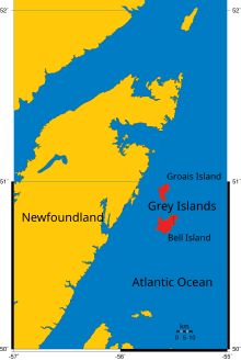
being the other. It has an area of 41 km and is located off
148:. The island is uninhabited, but was used earlier by fishermen.
56:
145:
207:"Grey Islands". The Columbia Gazetteer of North America, 2000.
156:
241:"Cook in Newfoundland. 1764. Part 1: January to August"
52:
227:Trésor du terroir. Les noms de lieux de la France
379:Uninhabited islands of Newfoundland and Labrador
370:
166:The island is hilly, rising to over 100 metres.
155:named this island Groais in remembrance of the
77:accompanying your translation by providing an
43:Click for important translation instructions.
35:expand this article with text translated from
353:
189:List of islands of Newfoundland and Labrador
360:
346:
384:Newfoundland and Labrador geography stubs
112:
371:
224:
312:
17:
13:
14:
395:
316:
22:
89:{{Translated|nl|Groais Island}}
233:
218:
200:
87:You may also add the template
1:
229:. CNRS Editions. p. 127.
332:. You can help Knowledge by
117:Groais Island, Grey Islands.
7:
184:Humber—St. Barbe—Baie Verte
177:
10:
400:
311:
194:
51:Machine translation, like
326:Newfoundland and Labrador
37:the corresponding article
138:Great Northern Peninsula
98:For more guidance, see
328:location article is a
225:Brunet, Roger (2016).
118:
116:
100:Knowledge:Translation
71:copyright attribution
291: /
140:to the east in the
212:2004-11-21 at the
119:
79:interlanguage link
341:
340:
295:50.933°N 55.600°W
111:
110:
44:
391:
362:
355:
348:
320:
313:
306:
305:
303:
302:
301:
296:
292:
289:
288:
287:
284:
256:
255:
253:
252:
243:. Archived from
237:
231:
230:
222:
216:
204:
90:
84:
57:Google Translate
42:
26:
25:
18:
399:
398:
394:
393:
392:
390:
389:
388:
369:
368:
367:
366:
309:
300:50.933; -55.600
299:
297:
293:
290:
285:
282:
280:
278:
277:
270:The Hitch-Hiker
259:
250:
248:
239:
238:
234:
223:
219:
214:Wayback Machine
205:
201:
197:
180:
157:island of Groix
151:Fishermen from
107:
106:
105:
88:
82:
45:
27:
23:
12:
11:
5:
397:
387:
386:
381:
365:
364:
357:
350:
342:
339:
338:
321:
275:
274:
265:
258:
257:
232:
217:
198:
196:
193:
192:
191:
186:
179:
176:
142:Atlantic Ocean
124:is one of the
109:
108:
104:
103:
96:
85:
63:
60:
49:
46:
32:
31:
30:
28:
21:
9:
6:
4:
3:
2:
396:
385:
382:
380:
377:
376:
374:
363:
358:
356:
351:
349:
344:
343:
337:
335:
331:
327:
322:
319:
315:
314:
310:
307:
304:
273:
271:
266:
264:
261:
260:
247:on 2007-02-19
246:
242:
236:
228:
221:
215:
211:
208:
203:
199:
190:
187:
185:
182:
181:
175:
172:
169:
164:
162:
158:
154:
149:
147:
143:
139:
135:
131:
127:
123:
122:Groais Island
115:
101:
97:
94:
86:
80:
76:
72:
68:
64:
61:
58:
54:
50:
48:
47:
40:
38:
33:You can help
29:
20:
19:
16:
334:expanding it
323:
308:
276:
269:
249:. Retrieved
245:the original
235:
226:
220:
202:
173:
165:
150:
134:Newfoundland
126:Grey Islands
121:
120:
75:edit summary
66:
34:
15:
298: /
268:Cal Coish,
130:Bell Island
373:Categories
263:IBA, birds
251:2007-02-04
168:James Cook
272:, page 20
93:talk page
210:Archived
178:See also
153:Brittany
69:provide
39:in Dutch
286:55°36′W
283:50°56′N
195:Sources
91:to the
73:in the
161:Breton
146:Canada
324:This
159:. In
53:DeepL
330:stub
67:must
65:You
144:in
136:'s
55:or
41:.
375::
128:,
361:e
354:t
347:v
336:.
254:.
102:.
95:.
Text is available under the Creative Commons Attribution-ShareAlike License. Additional terms may apply.
