123:
320:
830:
1043:
295:
110:
799:
789:
88:
1268:
1089:
78:
817:
56:
303:
744:
779:
130:
450:) characterized by warm summers and cool winters with light snowfall. The average annual temperature in Kan'onji is 15.5 °C. The average annual rainfall is 1439 mm with September as the wettest month. The temperatures are highest on average in August, at around 26.6 °C, and lowest in January, at around 4.9 °C.
307:
305:
310:
309:
304:
311:
728:
Kan'onji has ten public elementary schools and five public middle schools operated by the city government, and one private middle school. The city has two public high schools operated by the Kagawa
Prefectural Board of Education.The prefecture also operates one special education school for the
308:
306:
1241:
664:
with the creation of the modern municipalities system on
December 16,1878. It was elevated to town status on February 15, 1890. In 1899, Toyota district was merged with Mino District to form
696:
city council of 22 members. Kan'onji contributes three members to the Kagawa
Prefectural Assembly. In terms of national politics, the town is part of Kagawa 3rd district of the
933:
864:
637:
154:
883:
122:
1329:
855:
1305:
1042:
55:
1324:
1252:
1010:
697:
661:
109:
1032:
87:
1339:
712:
The economy of Kan'onji is primarily food-related, with the city being the largest producer of lettuce in Japan.
1088:
1298:
1334:
966:
367:
of 490 persons per km². The total area of the city is 117.84 square kilometres (45.50 sq mi).
77:
1190:
1060:
633:
458:
Per
Japanese census data, the population of Kan'onji has been gradually declining in recent decades.
443:
1213:
1291:
989:
879:
802:
396:
319:
194:
893:
622:
1166:
1149:
792:
747:
677:
665:
870:
629:
668:. Kan'onji was elevated to city status on January 1, 1955. On October 11, 2005, the towns of
1178:
1103:
1279:
1218:
1070:
1025:
887:
782:
380:
206:
294:
8:
1040:
821:
757:
277:
1133:
859:
713:
653:
431:
364:
1223:
906:
669:
1055:
1046:
977:
657:
352:
211:
1196:
1171:
1113:
761:
673:
411:
384:
1201:
1206:
1154:
1123:
1018:
765:
649:
610:
376:
348:
41:
1267:
1275:
1128:
1118:
912:
421:
1318:
875:
834:
816:
720:, and food-processing, notably the frozen food industry, is also prominent.
701:
689:
626:
169:
156:
65:
1183:
618:
388:
375:
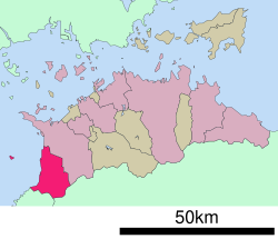
Kan'onji is located at the western end of Kagawa
Prefecture. It faces the
751:
693:
645:
360:
273:
1078:
953:
925:
268:
743:
842:
717:
641:
838:
199:
395:. Some coastal parts of the city are within the borders of the
392:
1159:
829:
614:
356:
613:
and has been inhabited since prehistoric times. A number of
359:. As of 1 October 2022, the city had an estimated
640:(from which the city derives its name) was founded by the
692:
form of government with a directly elected mayor and a
288:
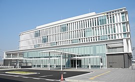
Sakamoto-cho 1-1-1, Kan-onji-shi, Kagawa-ken 768-8601
660:, the village of Kan'onji was established within
1316:
338:
946:
402:
332:
28:
1299:
1274:This Kagawa Prefecture location article is a
1026:
900:
845:, China, friendship city since July 27, 2000
648:, the city area was part of the holdings of
882:, includes a coin-shaped sand drawing, the
391:in the Seto Inland Sea between Shikoku and
1306:
1292:
1033:
1019:
625:. Historical documents indicate that the
609:The area of Kan'onji was part of ancient
102:Location of Kan'onji in Kagawa Prefecture
915:, politician, former Minister of Defense
318:
301:
293:
867:, 69th temple on the Shikoku Pilgrimage
824:, United States, since January 27, 1988
1317:
475:
242:117.84 km (45.50 sq mi)
1014:
1262:
1253:List of mergers in Kagawa Prefecture
849:
621:have been identified, including the
363:of 57,921 in 25510 households and a
129:
954:"Kan'onji city official statistics"
323:Aerial view of Kan'onji city center
13:
470:
14:
1351:
1330:Populated coastal places in Japan
919:
808:
732:
1266:
1087:
1041:
828:
815:
797:
787:
777:
742:
632:was founded in 703 and that the
387:to the south. The city includes
128:
121:
108:
86:
76:
54:
453:
982:
978:Kan'onji population statistics
971:
960:
934:A tourist's report of Kan'onji
926:Kan'onji City official website
1:
939:
683:
1278:. You can help Knowledge by
723:
370:
7:
1325:Cities in Kagawa Prefecture
771:
737:
403:Neighbouring municipalities
339:
10:
1356:
1261:
901:Noted people from Kan'onji
707:
604:
437:
1250:
1234:
1142:
1096:
1085:
1069:
1053:
909:, Prime Minister of Japan
488:—
444:humid subtropical climate
333:
284:
267:
263:490/km (1,300/sq mi)
259:
251:
246:
238:
233:
228:(since November 20, 2021)
222:
217:
205:
193:
185:
150:
116:
107:
100:
72:
53:
48:
39:
29:
21:
896:, National Historic Site
880:Setonaikai National Park
680:) merged with Kan'onji.
397:Setonaikai National Park
379:to the west and borders
25:
878:, which is part of the
803:National Route 377
748:Shikoku Railway Company
666:Mitoyo District, Kagawa
1340:Kagawa geography stubs
793:National Route 11
324:
316:
315:View of Kan'onji, 2021
299:
170:34.12722°N 133.66139°E
16:City in Shikoku, Japan
967:Kan'onji climate data
956:(in Japanese). Japan.
894:Ōnohara Kofun cluster
858:, 68th temple on the
623:Ōnohara Kofun cluster
462:Historical population
427:Tokushima Prefecture
322:
314:
297:
871:Kotohiki Hachiman-gū
783:Takamatsu Expressway
630:Kotohiki Hachiman-gū
381:Tokushima Prefecture
260: • Density
886:, which models the
822:Appleton, Wisconsin
644:in 803. During the
463:
175:34.12722; 133.66139
166: /
860:Shikoku Pilgrimage
714:Commercial fishing
654:Tokugawa shogunate
461:
417:Kagawa Prefecture
365:population density
325:
317:
300:
298:Kan'onji City Hall
252: • Total
239: • Total
223: • Mayor
60:Sand Coin Effigy (
1287:
1286:
1259:
1258:
1242:ja:ネット・ゲーム依存症対策条例
1191:Nakatado District
1064:
1047:Kagawa Prefecture
850:Local attractions
716:, especially for
658:Meiji restoration
602:
601:
407:Ehime Prefecture
353:Kagawa Prefecture
312:
292:
291:
285:City hall address
229:
142:Location in Japan
1347:
1335:Kan'onji, Kagawa
1308:
1301:
1294:
1270:
1263:
1091:
1058:
1045:
1035:
1028:
1021:
1012:
1011:
1005:
1004:
1002:
1000:
986:
980:
975:
969:
964:
958:
957:
950:
930:
833:
832:
820:
819:
801:
800:
791:
790:
781:
780:
746:
656:. Following the
477:
472:
464:
460:
385:Sanuki Mountains
346:
345:
342:
336:
335:
313:
227:
181:
180:
178:
177:
176:
171:
167:
164:
163:
162:
159:
132:
131:
125:
112:
90:
80:
58:
34:
33:
32:
31:
19:
18:
1355:
1354:
1350:
1349:
1348:
1346:
1345:
1344:
1315:
1314:
1313:
1312:
1260:
1255:
1246:
1230:
1167:Kagawa District
1150:Ayauta District
1138:
1092:
1083:
1065:
1049:
1039:
1009:
1008:
998:
996:
990:"Sister Cities"
988:
987:
983:
976:
972:
965:
961:
952:
951:
947:
942:
928:
922:
907:Masayoshi Ōhira
903:
852:
827:
814:
811:
798:
788:
778:
774:
740:
735:
726:
710:
688:Kan'onji has a
686:
678:Mitoyo District
662:Toyota District
650:Marugame Domain
634:Buddhist temple
611:Sanuki Province
607:
456:
442:Kan'onji has a
440:
405:
377:Seto Inland Sea
373:
343:
330:
302:
174:
172:
168:
165:
160:
157:
155:
153:
152:
146:
145:
144:
143:
140:
139:
138:
137:
133:
103:
96:
95:
94:
93:
84:
83:
68:
62:Zenigata suna-e
44:
35:
27:
26:
24:
17:
12:
11:
5:
1353:
1343:
1342:
1337:
1332:
1327:
1311:
1310:
1303:
1296:
1288:
1285:
1284:
1271:
1257:
1256:
1251:
1248:
1247:
1245:
1244:
1238:
1236:
1232:
1231:
1229:
1228:
1227:
1226:
1221:
1214:Shōzu District
1211:
1210:
1209:
1204:
1199:
1188:
1187:
1186:
1176:
1175:
1174:
1164:
1163:
1162:
1157:
1146:
1144:
1140:
1139:
1137:
1136:
1131:
1126:
1121:
1116:
1111:
1106:
1100:
1098:
1094:
1093:
1086:
1084:
1082:
1081:
1075:
1073:
1067:
1066:
1054:
1051:
1050:
1038:
1037:
1030:
1023:
1015:
1007:
1006:
981:
970:
959:
944:
943:
941:
938:
937:
936:
931:
921:
920:External links
918:
917:
916:
913:Yoshinori Ohno
910:
902:
899:
898:
897:
891:
884:Zenigata Sunae
873:
868:
862:
851:
848:
847:
846:
825:
810:
809:Sister citiess
807:
806:
805:
795:
785:
773:
770:
769:
768:
739:
736:
734:
733:Transportation
731:
725:
722:
709:
706:
685:
682:
606:
603:
600:
599:
596:
593:
589:
588:
585:
582:
578:
577:
574:
571:
567:
566:
563:
560:
556:
555:
552:
549:
545:
544:
541:
538:
534:
533:
530:
527:
523:
522:
519:
516:
512:
511:
508:
505:
501:
500:
497:
494:
490:
489:
486:
483:
479:
478:
473:
468:
455:
452:
439:
436:
435:
434:
425:
424:
415:
414:
404:
401:
372:
369:
290:
289:
286:
282:
281:
271:
265:
264:
261:
257:
256:
253:
249:
248:
244:
243:
240:
236:
235:
231:
230:
226:Akihiro Saeki
224:
220:
219:
215:
214:
209:
203:
202:
197:
191:
190:
187:
183:
182:
148:
147:
141:
135:
134:
127:
126:
120:
119:
118:
117:
114:
113:
105:
104:
101:
98:
97:
91:
85:
81:
75:
74:
73:
70:
69:
59:
51:
50:
46:
45:
40:
37:
36:
22:
15:
9:
6:
4:
3:
2:
1352:
1341:
1338:
1336:
1333:
1331:
1328:
1326:
1323:
1322:
1320:
1309:
1304:
1302:
1297:
1295:
1290:
1289:
1283:
1281:
1277:
1272:
1269:
1265:
1264:
1254:
1249:
1243:
1240:
1239:
1237:
1233:
1225:
1222:
1220:
1217:
1216:
1215:
1212:
1208:
1205:
1203:
1200:
1198:
1195:
1194:
1192:
1189:
1185:
1182:
1181:
1180:
1179:Kita District
1177:
1173:
1170:
1169:
1168:
1165:
1161:
1158:
1156:
1153:
1152:
1151:
1148:
1147:
1145:
1141:
1135:
1132:
1130:
1127:
1125:
1122:
1120:
1117:
1115:
1112:
1110:
1107:
1105:
1104:Higashikagawa
1102:
1101:
1099:
1095:
1090:
1080:
1077:
1076:
1074:
1072:
1068:
1062:
1057:
1052:
1048:
1044:
1036:
1031:
1029:
1024:
1022:
1017:
1016:
1013:
995:
991:
985:
979:
974:
968:
963:
955:
949:
945:
935:
932:
929:(in Japanese)
927:
924:
923:
914:
911:
908:
905:
904:
895:
892:
889:
885:
881:
877:
876:Kotohiki Park
874:
872:
869:
866:
863:
861:
857:
854:
853:
844:
840:
836:
835:Jimo District
831:
826:
823:
818:
813:
812:
804:
796:
794:
786:
784:
776:
775:
767:
763:
759:
756:
755:
754:
753:
749:
745:
730:
729:handicapped.
721:
719:
715:
705:
703:
702:Diet of Japan
699:
695:
691:
690:mayor-council
681:
679:
675:
671:
667:
663:
659:
655:
651:
647:
643:
639:
635:
631:
628:
627:Shinto shrine
624:
620:
616:
615:burial mounds
612:
597:
594:
591:
590:
586:
583:
580:
579:
575:
572:
569:
568:
564:
561:
558:
557:
553:
550:
547:
546:
542:
539:
536:
535:
531:
528:
525:
524:
520:
517:
514:
513:
509:
506:
503:
502:
498:
495:
492:
491:
487:
484:
481:
480:
474:
469:
466:
465:
459:
451:
449:
445:
433:
430:
429:
428:
423:
420:
419:
418:
413:
410:
409:
408:
400:
398:
394:
390:
386:
382:
378:
368:
366:
362:
358:
354:
350:
341:
329:
321:
296:
287:
283:
279:
275:
272:
270:
266:
262:
258:
254:
250:
245:
241:
237:
232:
225:
221:
216:
213:
210:
208:
204:
201:
198:
196:
192:
188:
184:
179:
151:Coordinates:
149:
124:
115:
111:
106:
99:
89:
79:
71:
67:
66:Kotohiki Park
63:
57:
52:
49:Kan'onji City
47:
43:
38:
20:
1280:expanding it
1273:
1108:
997:. Retrieved
994:appleton.org
993:
984:
973:
962:
948:
888:Kan'ei Tsūhō
741:
727:
711:
687:
619:Kofun period
608:
457:
454:Demographics
447:
441:
426:
416:
406:
389:Ibuki island
374:
340:Kan'onji-shi
327:
326:
61:
698:lower house
676:(both from
412:Shikokuchūō
383:across the
351:located in
173: /
161:133°39′41″E
1319:Categories
1219:Shōdoshima
999:August 30,
940:References
752:Yosan Line
694:unicameral
684:Government
652:under the
646:Edo Period
361:population
247:Population
218:Government
207:Prefecture
1143:Districts
1079:Takamatsu
1071:Core city
1056:Takamatsu
865:Kannon-ji
724:Education
638:Kannon-ji
617:from the
371:Geography
274:UTC+09:00
269:Time zone
158:34°7′38″N
1197:Kotohira
1172:Naoshima
1134:Zentsūji
1114:Marugame
1109:Kan'onji
856:Jinne-in
843:Shandong
772:Highways
762:Toyohama
758:Kan'onji
738:Railways
718:sardines
674:Toyohama
446:(Köppen
328:Kan'onji
136:Kan'onji
23:Kan'onji
1224:Tonoshō
1207:Tadotsu
1155:Ayagawa
1124:Sakaide
1061:capital
839:Qingdao
766:Minoura
708:Economy
700:of the
670:Ōnohara
605:History
438:Climate
432:Miyoshi
200:Shikoku
186:Country
1235:Others
1129:Sanuki
1119:Mitoyo
1097:Cities
595:57,438
584:62,690
573:66,555
562:68,436
551:68,435
540:66,653
529:73,186
521:+33.5%
518:78,356
507:58,708
496:58,228
485:54,251
422:Mitoyo
393:Honshu
255:57,921
212:Kagawa
195:Region
92:Emblem
1202:Mannō
1160:Utazu
642:Kūkai
598:−8.4%
592:2020
587:−5.8%
581:2010
576:−2.7%
570:2000
565:+0.0%
559:1990
554:+2.7%
548:1980
543:−8.9%
537:1970
532:−6.6%
526:1960
515:1950
510:+0.8%
504:1940
499:+7.3%
493:1930
482:1920
357:Japan
347:is a
189:Japan
64:) in
1276:stub
1184:Miki
1001:2020
672:and
471:Pop.
467:Year
349:city
334:観音寺市
234:Area
82:Flag
42:City
30:観音寺市
636:of
448:Cfa
278:JST
1321::
1193::
992:.
841:,
837:,
764:-
760:-
750:-
704:.
476:±%
399:.
355:,
337:,
1307:e
1300:t
1293:v
1282:.
1063:)
1059:(
1034:e
1027:t
1020:v
1003:.
890:.
344:)
331:(
280:)
276:(
Text is available under the Creative Commons Attribution-ShareAlike License. Additional terms may apply.


