397:
947:
388:
34:
524:
534:
544:
1041:
1029:
702:
1053:
505:, for accompanied vehicles. The journey time of approximately 20 minutes, passengers remain in their cars in open sided car transport vehicles. At peak times, the car transport service operates in each direction every 7½ minutes.
477:
valley and flooded with water and glacial deposit from the fissure, killing 25, and 1554 meters (5100 feet, 0.9656 mile) of the tunnel had to be abandoned and sealed off and replaced by a curved bypass.
53:
400:
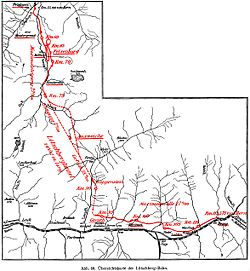
The Lötschberg Tunnel in the outline of the Lötschberg Line showing the planned straight and realized curved tunnel between km 75 and 90. Positions are indicated in travel distance from Bern in .
673:
2002. "TUNNELS - Lotschberg Team
Advances Swiftly Through the Alps - Teams Using TBMs and Drill-and-Blast Methods Drive Tunnel That Will Speed Trucks Through Switzerland".
657:
Vuilleumier, F., A. Weatherill, and B. Crausaz. 2002. "Safety
Aspects of Railway and Road Tunnel: Example of the Lotschberg Railway Tunnel and Mont-Blanc Road Tunnel".
913:
681:
714:
980:
512:, opened on June 15, 2007, has been constructed some 400 m (1,312 ft) below the level of the current Lötschberg Tunnel as part of the
970:
650:
Pesendorfer, M., and S. Loew. 2004. "Hydrogeologic
Exploration During Excavation of the Lotschberg Base Tunnel (AlpTransit Switzerland)".
1103:
1078:
943:
706:
1093:
783:
456:
1073:
616:
645:
Elektrische Bahnen; Zentralblatt F̐ưur
Elektrischen Zugbetrieb Und Alle Arten Von Triebfahrzeugen Mit Elektrischem Antrieb
638:
Elektrische Bahnen; Zentralblatt F̐ưur
Elektrischen Zugbetrieb Und Alle Arten Von Triebfahrzeugen Mit Elektrischem Antrieb
145:
114:
1088:
348:
1098:
935:
686:
666:
1108:
474:
107:
872:
502:
1019:
882:
860:
498:
778:
752:
1083:
887:
1001:
817:
802:
566:
509:
20:
855:
811:
788:
877:
343:
598:: Enzyklopädie des Eisenbahnwesens, Band 2. Berlin, Wien 1912, p. 256 on www.zeno.org/Roell-1912
985:
892:
295:
773:
965:
897:
828:
823:
767:
455:. The top elevation of the tunnel is 1,240 m (4,070 ft) above sea level, this is
424:
301:
8:
1033:
636:
Baumgartner, B., and M. Lortscher. 2007. "Commissioning of the
Lotschberg Base Tunnel".
1045:
975:
928:
396:
416:
71:
33:
612:
387:
523:
452:
213:
99:
82:
533:
57:
1006:
664:
2000. "Lötschberg Base Tunnel Will Open Up Low-Level High-Cube Route in 2007".
571:
444:
428:
335:
198:
95:
743:
643:
Lortscher, M., et al. "Electric
Installations in the Lotschberg Base Tunnel."
1067:
1057:
921:
729:
716:
371:
160:
147:
129:
116:
561:
462:
Construction began in 1907 and suffered delays by several severe accidents.
432:
86:
486:
15 July 1913: Regular service through the Lötschberg Tunnel began in 1913.
946:
543:
448:
436:
308:
209:
184:
90:
440:
194:
467:
497:
company offers a car transport service through the tunnel, between
409:
749:
701:
494:
412:
255:
245:
180:
1028:
901:
832:
420:
951:
576:
513:
1052:
473:
July 1908: The tunnel broke into a deep fissure below the
682:
Tracklaying
Reaches Halfway in the Lötschberg Base Tunnel
547:
Car transport through the Lötschberg tunnel (Kandersteg)
470:
destroyed a hotel that the workers lived in, killing 13.
1017:
527:
457:
the highest point of the main Swiss railway network
537:South portal from Goppenstein (1216 m a.s.l.)
611:. Verlag Schweers + Wall GmbH. 2012. p. 45.
1065:
748:
929:
659:Tunnelling and Underground Space Technology
366:1,200 m (3,900 ft) (north portal)
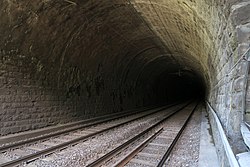
38:The Lötschberg Tunnel from the north portal
936:
922:
408:is a 14.612 km (9.079 mi) long
542:
532:
522:
514:NRLA (New Railway Link through the Alps)
490:The tunnel is a single bore twin track.
395:
16:Railway tunnel through the Bernese Alps
1066:
952:New Railway Link through the Alps NRLA
917:
747:
601:
480:March 1911: Breakthrough was achieved
19:For the tunnel opened in 2007, see
13:
1104:1913 establishments in Switzerland
1079:Buildings and structures in Valais
629:
14:
1120:
695:
358:1,239.54 m (4,066.7 ft)
273:Passenger, Freight, Car Transport
1051:
1039:
1027:
945:
700:
386:
32:
1094:Transport in the canton of Bern
652:Lecture Notes in Earth Sciences
439:. Its ends are at the towns of
1074:Railway tunnels in Switzerland
589:
291:
286:14.612 km (9.079 mi)
216:, 1,216 m (3,990 ft)
201:, 1,200 m (3,900 ft)
1:
687:Railway Gazette International
667:Railway Gazette International
582:
7:
555:
427:at the northern end of the
10:
1125:
18:
1089:Tunnels completed in 1913
994:
958:
842:
798:
759:
483:3 June 1913: Finalization
385:
380:
370:
362:
354:
342:
307:
290:
282:
277:
269:
261:
251:
241:
233:
225:
220:
205:
190:
176:
106:
77:
67:
48:
43:
31:
784:Reichenbach im Kandertal
753:Lötschberg railway line
690:. 161, no. 12: 773-775.
1002:Lötschberg Base Tunnel
986:Zimmerberg Base Tunnel
818:Lötschberg Base Tunnel
803:Lötschberg Base Tunnel
707:Lötschberg rail Tunnel
609:Eisenbahnatlas Schweiz
567:Lötschberg Base Tunnel
548:
538:
528:
510:Lötschberg Base Tunnel
401:
61:
21:Lötschberg Base Tunnel
709:at Wikimedia Commons
661:. 17, no. 2: 153-158.
596:Röll, V. Freiherr von
546:
536:
526:
399:
185:SBB CFF FFS
966:Gotthard Base Tunnel
730:46.43028°N 7.71806°E
647:. 6 (2007): 323-344.
431:cutting through the
1109:Tunnels in the Alps
726: /
654:. no. 104: 347-358.
503:Goppenstein station
443:(2 km away) in the
157: /
126: /
28:
1099:Bern–Valais border
976:Ceneri Base Tunnel
549:
539:
529:
499:Kandersteg station
466:February 1908: An
402:
81:Circumventing the
49:Official name
26:
1015:
1014:
911:
910:
867:Lötschberg Tunnel
847:Lötschberg Tunnel
735:46.43028; 7.71806
705:Media related to
677:. 249, no. 3: 28.
640:. no. 6: 345-350.
618:978-3-89494-130-7
553:
552:
419:, which connects
406:Lötschberg Tunnel
394:
393:
355:Highest elevation
62:Lötschberg Tunnel
27:Lötschberg Tunnel
1116:
1084:Bernese Oberland
1056:
1055:
1044:
1043:
1042:
1032:
1031:
1023:
950:
949:
938:
931:
924:
915:
914:
760:Spiez - Frutigen
745:
744:
741:
740:
738:
737:
736:
731:
727:
724:
723:
722:
719:
704:
623:
622:
605:
599:
593:
519:
518:
453:canton of Valais
390:
363:Lowest elevation
333:
331:
330:
326:
323:
315:
293:
214:canton of Valais
172:
171:
169:
168:
167:
162:
161:46.478°N 7.667°E
158:
155:
154:
153:
150:
141:
140:
138:
137:
136:
131:
130:46.369°N 7.754°E
127:
124:
123:
122:
119:
100:canton of Valais
56:
36:
29:
25:
1124:
1123:
1119:
1118:
1117:
1115:
1114:
1113:
1064:
1063:
1062:
1050:
1040:
1038:
1026:
1018:
1016:
1011:
995:Lötschberg axis
990:
981:Urmiberg Tunnel
954:
944:
942:
912:
907:
844:
843:Frutigen - Brig
838:
800:
799:Frutigen - Brig
794:
755:
734:
732:
728:
725:
720:
717:
715:
713:
712:
698:
693:
670:. 156: 175-182.
632:
630:Further reading
627:
626:
619:
607:
606:
602:
594:
590:
585:
558:
417:Lötschberg Line
328:
324:
321:
319:
318:4 ft
317:
313:
165:
163:
159:
156:
151:
148:
146:
144:
143:
134:
132:
128:
125:
120:
117:
115:
113:
112:
93:
72:Lötschberg Line
52:
39:
24:
17:
12:
11:
5:
1122:
1112:
1111:
1106:
1101:
1096:
1091:
1086:
1081:
1076:
1061:
1060:
1048:
1036:
1013:
1012:
1010:
1009:
1007:Simplon Tunnel
1004:
998:
996:
992:
991:
989:
988:
983:
978:
973:
968:
962:
960:
956:
955:
941:
940:
933:
926:
918:
909:
908:
906:
905:
895:
890:
885:
880:
875:
870:
863:
858:
851:
849:
840:
839:
837:
836:
826:
821:
814:
807:
805:
796:
795:
793:
792:
786:
781:
776:
771:
763:
761:
757:
756:
697:
696:External links
694:
692:
691:
678:
671:
662:
655:
648:
641:
633:
631:
628:
625:
624:
617:
600:
587:
586:
584:
581:
580:
579:
574:
572:Simplon Tunnel
569:
564:
557:
554:
551:
550:
540:
530:
488:
487:
484:
481:
478:
471:
445:canton of Bern
429:Simplon Tunnel
392:
391:
383:
382:
378:
377:
374:
368:
367:
364:
360:
359:
356:
352:
351:
346:
340:
339:
336:standard gauge
311:
305:
304:
298:
288:
287:
284:
280:
279:
275:
274:
271:
267:
266:
263:
259:
258:
253:
249:
248:
243:
239:
238:
235:
231:
230:
227:
223:
222:
218:
217:
207:
203:
202:
199:canton of Bern
192:
188:
187:
178:
174:
173:
110:
104:
103:
96:Canton of Bern
79:
75:
74:
69:
65:
64:
50:
46:
45:
41:
40:
37:
15:
9:
6:
4:
3:
2:
1121:
1110:
1107:
1105:
1102:
1100:
1097:
1095:
1092:
1090:
1087:
1085:
1082:
1080:
1077:
1075:
1072:
1071:
1069:
1059:
1054:
1049:
1047:
1037:
1035:
1030:
1025:
1024:
1021:
1008:
1005:
1003:
1000:
999:
997:
993:
987:
984:
982:
979:
977:
974:
972:
969:
967:
964:
963:
961:
959:Gotthard axis
957:
953:
948:
939:
934:
932:
927:
925:
920:
919:
916:
903:
899:
896:
894:
891:
889:
886:
884:
881:
879:
876:
874:
871:
868:
864:
862:
859:
857:
853:
852:
850:
848:
841:
834:
830:
827:
825:
822:
819:
815:
813:
809:
808:
806:
804:
797:
790:
787:
785:
782:
780:
777:
775:
772:
769:
765:
764:
762:
758:
754:
751:
746:
742:
739:
710:
708:
703:
689:
688:
683:
679:
676:
672:
669:
668:
663:
660:
656:
653:
649:
646:
642:
639:
635:
634:
620:
614:
610:
604:
597:
592:
588:
578:
575:
573:
570:
568:
565:
563:
560:
559:
545:
541:
535:
531:
525:
521:
520:
517:
515:
511:
506:
504:
500:
496:
491:
485:
482:
479:
476:
472:
469:
465:
464:
463:
460:
458:
454:
450:
446:
442:
438:
434:
430:
426:
422:
418:
414:
411:
407:
398:
389:
384:
379:
375:
373:
369:
365:
361:
357:
353:
350:
349:15 kV 16.7 Hz
347:
345:
341:
337:
314:1,435 mm
312:
310:
306:
303:
299:
297:
289:
285:
281:
276:
272:
268:
264:
260:
257:
254:
250:
247:
244:
240:
236:
232:
228:
224:
219:
215:
211:
208:
204:
200:
196:
193:
189:
186:
182:
179:
175:
170:
166:46.478; 7.667
139:
135:46.369; 7.754
111:
109:
105:
101:
97:
92:
88:
84:
83:Lötschen Pass
80:
76:
73:
70:
66:
63:
59:
55:
51:
47:
42:
35:
30:
22:
1034:Architecture
866:
846:
711:
699:
685:
674:
665:
658:
651:
644:
637:
608:
603:
595:
591:
507:
492:
489:
461:
433:Bernese Alps
405:
403:
302:double-track
237:15 July 1913
229:7 March 1907
87:Bernese Alps
1046:Switzerland
971:Axen Tunnel
873:Goppenstein
733: /
449:Goppenstein
437:Switzerland
344:Electrified
309:Track gauge
246:BLS NETZ AG
210:Goppenstein
164: /
133: /
108:Coordinates
91:Switzerland
1068:Categories
883:Ausserberg
861:Kandersteg
766:(<<
718:46°25′49″N
583:References
562:Lötschberg
475:Gasterntal
441:Kandersteg
376:3–7 ‰
226:Work begun
195:Kandersteg
149:46°28′41″N
118:46°22′08″N
900:(>>
888:Eggerberg
831:(>>
516:project.
468:avalanche
381:Route map
278:Technical
270:Character
221:Operation
152:7°40′01″E
121:7°45′14″E
54:‹See Tfd›
856:Frutigen
812:Frutigen
789:Frutigen
721:7°43′5″E
556:See also
508:The new
332: in
252:Operator
78:Location
44:Overview
1020:Portals
878:Hohtenn
779:Mülenen
680:2005. "
451:in the
415:on the
410:railway
327:⁄
265:Railway
262:Traffic
85:in the
1058:Trains
893:Lalden
615:
495:BLS AG
413:tunnel
296:tracks
283:Length
234:Opened
177:System
58:German
902:Italy
833:Italy
774:Spiez
421:Spiez
372:Grade
242:Owner
191:Start
898:Brig
845:via
829:Brig
824:Visp
801:via
768:Thun
675:ENR.
613:ISBN
577:NRLA
501:and
493:The
447:and
425:Brig
423:and
404:The
300:One
68:Line
750:BLS
684:".
435:of
334:) (
294:of
292:No.
256:BLS
206:End
181:BLS
89:in
1070::
854:—
810:—
459:.
212:,
197:,
183:,
142:–
98:,
60::
1022::
937:e
930:t
923:v
904:)
869:)
865:(
835:)
820:)
816:(
791:—
770:)
621:.
338:)
329:2
325:1
322:+
320:8
316:(
102:)
94:(
23:.
Text is available under the Creative Commons Attribution-ShareAlike License. Additional terms may apply.

