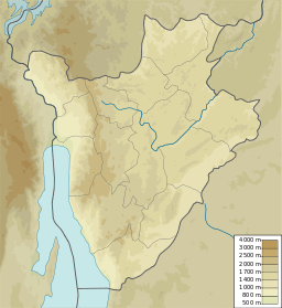
44:
51:
237:
Lake Gitama is protected as an "Integral Zone", where human presence will be phased out. Buffer zones, or belts of land at least 50 metres (160 ft) wide, will be established around the zone.
90:
148:
357:
362:
43:
330:
313:
293:
8:
206:
222:
190:
72:
136:
27:
218:
214:
351:
210:
164:
150:
106:
92:
315:
Kagera TAMP - Bugesera aquatic landscapes endowed with a management plan
229:
is to the north-northwest. Lake Gitamo covers 21 hectares (52 acres).
258:
194:
76:
226:
292:
264:
270:
246:
295:
Fiche descriptive sur les zones humides Ramsar (FDR)
209:. It empties into a marshy corridor that leads from
349:
83:
318:, Kirundo province, Burundi: FAO, 8 July 2011
225:, which also drains to the Akanyaru River.
329:
312:
276:
252:
350:
50:
13:
14:
374:
49:
42:
1:
331:"Way: Lac Gitamo (125766573)"
240:
232:
265:Fiche descriptive ... Ramsar
7:
200:
10:
379:
358:Protected areas of Burundi
301:(in French), 14 March 2013
285:
363:Lakes of Kirundo Province
82:
68:
37:
26:
21:
205:Lake Gitamo is in the
140:
31:
165:2.51944°S 30.05417°E
107:2.51944°S 30.05417°E
207:Commune of Bugabira
160: /
102: /
170:-2.51944; 30.05417
112:-2.51944; 30.05417
221:. It is south of
189:is a lake in the
130:
129:
370:
343:
342:
341:
326:
325:
323:
309:
308:
306:
300:
280:
274:
268:
262:
256:
250:
223:Lake Gacamirindi
191:Kirundo Province
184:
183:
181:
180:
179:
177:
172:
171:
166:
161:
158:
157:
156:
153:
126:
125:
123:
122:
121:
119:
114:
113:
108:
103:
100:
99:
98:
95:
85:
73:Kirundo Province
53:
52:
46:
19:
18:
378:
377:
373:
372:
371:
369:
368:
367:
348:
347:
346:
339:
337:
321:
319:
304:
302:
298:
288:
283:
277:Kagera TAMP FAO
275:
271:
263:
259:
253:Way: Lac Gitamo
251:
247:
243:
235:
203:
175:
173:
169:
167:
163:
162:
159:
154:
151:
149:
147:
146:
117:
115:
111:
109:
105:
104:
101:
96:
93:
91:
89:
88:
64:
63:
62:
61:
60:
59:
58:
54:
17:
16:Lake in Burundi
12:
11:
5:
376:
366:
365:
360:
345:
344:
327:
310:
289:
287:
284:
282:
281:
269:
257:
244:
242:
239:
234:
231:
219:Akanyaru River
215:Lake Narungazi
202:
199:
128:
127:
86:
80:
79:
70:
66:
65:
56:
55:
48:
47:
41:
40:
39:
38:
35:
34:
24:
23:
15:
9:
6:
4:
3:
2:
375:
364:
361:
359:
356:
355:
353:
336:
335:OpenStreetMap
332:
328:
317:
316:
311:
297:
296:
291:
290:
278:
273:
266:
261:
254:
249:
245:
238:
230:
228:
224:
220:
216:
212:
211:Lake Rwihinda
208:
198:
196:
192:
188:
187:Lake Nagitamo
182:
144:
143:
138:
134:
124:
87:
81:
78:
74:
71:
67:
45:
36:
33:
29:
25:
20:
338:, retrieved
334:
320:, retrieved
314:
303:, retrieved
294:
272:
267:, p. 4.
260:
248:
236:
204:
186:
141:
132:
131:
176:Lake Gitamo
168: /
133:Lake Gitamo
118:Lake Gitamo
110: /
84:Coordinates
57:Lake Gitamo
22:Lake Gitamo
352:Categories
340:2024-06-11
241:References
233:Protection
174: (
155:30°03′15″E
142:Lac Gitamo
116: (
97:30°03′15″E
32:Lac Gitamo
152:2°31′10″S
94:2°31′10″S
201:Location
69:Location
286:Sources
217:to the
195:Burundi
77:Burundi
322:9 June
305:9 June
227:Ruhehe
185:), or
137:French
28:French
299:(PDF)
324:2024
307:2024
213:and
193:of
75:of
354::
333:,
197:.
145:,
139::
30::
279:.
255:.
178:)
135:(
120:)
Text is available under the Creative Commons Attribution-ShareAlike License. Additional terms may apply.
