130:
182:
114:
52:
158:
late 1920s, the
Carolina Power and Light Company established the community of Waterville at the mountain's northern base, near the confluence of Big Creek and the Pigeon River. Waterville provided the labor force needed to operate the company's Walters Plant, which housed the powerhouse for the Waterville reservoir further upstream. While vestiges of Waterville survived, Crestmont was absorbed into the
157:
Around 1903, the
Cataloochee Lumber Company established the village of Crestmont at the northwest base of Mount Sterling to house a labor force needed to log the Big Creek Valley and operate a timber mill. Crestmont thrived until 1907, when the company commenced logging operations in the area. In the
193:
The 5.3-mile (8.5 km) Mount
Sterling Ridge Trail traverses the ridge's crest between Laurel Gap on Balsam Mountain and the summit of Mount Sterling. The 6.1-mile (9.8 km) Baxter Creek Trail connects the summit to the Big Creek Campground to the north. These two trails provide segments of
153:
navigated through the area by following a trail that connected Cosby and
Cataloochee via Mount Sterling. One local legend relates an incident in which Confederate Captain Albert Teague swept through Cataloochee and arrested three alleged Union sympathizers. Teague marched them up to Mount Sterling
189:
A long gravel road connects the Big Creek ranger station (near
Waterville) with the Cataloochee Campground. The trailhead for the 2.7-mile (4.3 km) Mount Sterling Trail is located near this road's halfway point at Mount Sterling Gap. The trail ascends to the summit.
125:
in the bed of the Pigeon River at the mountain's northern base. These early residents mistakenly thought the lead was silver. The Big Creek campground, at the northern base of Mount
Sterling Ridge, occupies what was once the community of Mount Sterling, North Carolina.
154:
where he ordered one of the detainees, a well-known local fiddle player named Henry Grooms, to play a tune on his fiddle. Grooms chose the somber "Bonaparte's
Retreat." When he finished, Teague executed all three detainees.
96:
area) to the west. The communities of Mount
Sterling, North Carolina, and Waterville, North Carolina are located in the Pigeon River valley at the ridge's northern extreme. Geologically, Mount Sterling consists mainly of
198:. The Pretty Hollow Gap Trail connects Mount Sterling with Cataloochee to the east, and the Swallow Fork Trail connects the mountain with Walnut Bottom in the Big Creek Valley to the west.
84:
Mount
Sterling crowns Mount Sterling Ridge, a 7-mile (11 km) ridge that gradually descends northward from the flanks of Big Cataloochee Mountain (on the Balsam Mountain crest) to the
101:
metamorphic sandstone of the Ocoee
Supergroup, formed nearly a billion years ago from ancient ocean sediments. The summit of Mount Sterling is surrounded by a stand of
1098:
1083:
475:
1093:
362:
1103:
865:
786:
242:
337:— Non-profit partner of the National Park, creator of all official park maps and guides, and operates all official park information and visitor centers
857:
861:
21:
730:
85:
102:
841:
801:
776:
735:
355:
1027:
677:
821:
121:
According to early residents in the Mount Sterling area, the mountain was named after a 2-foot (0.61 m) wide streak of
1088:
348:
215:
896:
571:
371:
159:
89:
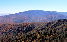
77:, located in the southeastern United States. It reaches an elevation of 5,842 feet (1,781 m) above sea level. The
831:
771:
811:
596:
439:
1037:
1017:
972:
411:
141:, Cataloochee and the remote valleys at the base of Mount Sterling became popular hideouts for deserters, and both
933:
886:
881:
781:
766:
846:
682:
480:
70:
239:
761:
146:
424:
891:
956:
142:
1042:
836:
644:
74:
129:
505:
462:
181:
992:
523:
66:
982:
876:
816:
616:
513:
379:
195:
166:
8:
920:
806:
667:
1062:
1002:
943:
871:
639:
1047:
1012:
1007:
987:
977:
951:
796:
700:
672:
470:
447:
1022:
692:
93:
928:
906:
536:
485:
246:
329:
997:
851:
751:
722:
649:
621:
586:
576:
556:
429:
388:
322:
219:
138:
113:
92:
area to the east from the Big Creek Valley (which represents the fringe of the
56:
340:
1077:
1032:
791:
756:
631:
581:
566:
561:
170:
51:
36:
23:
149:
detachments consistently made raids into the area to find them. Raiders and
901:
611:
546:
531:
495:
490:
259:
A Roadside Guide to the Geology of the Great Smoky Mountains National Park
1057:
826:
712:
659:
606:
150:
98:
81:
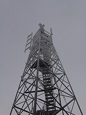
is topped by an abandoned fire tower that overlooks other nearby peaks.
1052:
601:
551:
452:
287:(Gatlinburg, Tenn.: Great Smoky Mountains Association, 2003), 159-162.
162:
in the 1930s and converted into what is now the Big Creek Campground.
419:
401:
334:
705:
396:
173:, was first noticed in the Smokies atop Mount Sterling in 1963.
541:
78:
261:(Knoxville, Tenn.: University of Tennessee Press, 1988), 32.
309:(Portland, Ore: Graphic Arts Center Publishing, 1993), 114.
122:
16:
Mountain in North Carolina and Tennessee, United States
1099:Protected areas of Haywood County, North Carolina
169:infestation, which killed off most of the park's
1084:Mountains of Great Smoky Mountains National Park
1075:
856:Rich Mountain, near Boone, Watauga County - 1)
370:
356:
1094:Natural history of the Great Smoky Mountains
1104:Mountains of Haywood County, North Carolina
363:
349:
736:North Carolina-Tennessee-Virginia Corners
274:(Newport, Tenn.: Clifton Club, 1970), 64.
270:Rolfe Godshalk (ed.), "Mount Sterling."
180:
128:
112:
50:
476:Chestnut Mountain (Transylvania County)
1076:
103:Southern Appalachian spruce–fir forest
344:
335:The Great Smoky Mountains Association
787:Chestnut Mountain (Caldwell County)
307:Great Smoky Mountains National Park
160:Great Smoky Mountains National Park
13:
233:
208:
14:
1115:
316:
299:
290:
277:
264:
251:
88:valley. The ridge divides the
71:Haywood County, North Carolina
1:
201:
117:Firetower atop Mount Sterling
285:History Hikes of the Smokies
7:
1089:Mountains of North Carolina
372:Mountains of North Carolina
185:Mount Sterling fall foliage
133:Mount Sterling fall foliage
55:Mount Sterling viewed from
10:
1120:
108:
965:
942:
919:
744:
721:
691:
658:
630:
522:
504:
461:
438:
410:
387:
378:
176:
1043:Standing Indian Mountain
837:Little Chestnut Mountain
645:North Eaglenest Mountain
75:Cocke County, Tennessee
678:Little Yellow Mountain
506:Great Craggy Mountains
463:Great Balsam Mountains
325:— Peakbagger.com
186:
134:
118:
59:
524:Great Smoky Mountains
216:"Tarheel High Points"
184:
132:
116:
67:Great Smoky Mountains
65:is a mountain in the
54:
1028:Occoneechee Mountain
983:Cane Creek Mountains
877:Spanish Oak Mountain
822:Grandmother Mountain
817:Grandfather Mountain
617:Thunderhead Mountain
514:Beaucatcher Mountain
380:Blue Ridge Mountains
196:Benton MacKaye Trail
167:balsam wooly adelgid
921:Sauratown Mountains
807:Fire Scale Mountain
668:Big Yellow Mountain
240:Smoky Mountain News
37:35.7023°N 83.1222°W
33: /
1063:Whiteside Mountain
1003:Looking Glass Rock
993:Devil's Courthouse
944:Uwharrie Mountains
897:Three Top Mountain
872:Sassafras Mountain
866:Rich Mountain Bald
860:(SSW of Boone) 2)
640:Eaglenest Mountain
245:2006-11-13 at the
194:the cross-country
187:
135:
119:
60:
1071:
1070:
1048:Terrells Mountain
1013:McAlpine Mountain
1008:Mayfield Mountain
988:Crowders Mountain
978:Big Butt Mountain
952:Caraway Mountains
915:
914:
864:(NW of Boone) 3)
832:Humpback Mountain
797:Doe Hill Mountain
772:Bluerock Mountain
701:Bob Stratton Bald
673:Grassy Ridge Bald
471:Black Balsam Knob
448:Hibriten Mountain
42:35.7023; -83.1222
1111:
1023:Mulatto Mountain
812:Flattop Mountain
693:Unicoi Mountains
440:Brushy Mountains
385:
384:
365:
358:
351:
342:
341:
310:
303:
297:
296:Godshalk, 64-66.
294:
288:
283:Michal Strutin,
281:
275:
268:
262:
255:
249:
237:
231:
230:
228:
227:
218:. Archived from
212:
48:
47:
45:
44:
43:
38:
34:
31:
30:
29:
26:
1119:
1118:
1114:
1113:
1112:
1110:
1109:
1108:
1074:
1073:
1072:
1067:
1038:South Mountains
1018:Mount Jefferson
973:Albert Mountain
961:
957:Morrow Mountain
938:
911:
740:
717:
687:
654:
626:
537:Charlies Bunion
518:
500:
486:Richland Balsam
457:
434:
412:Black Mountains
406:
374:
369:
328:Mount Sterling
319:
314:
313:
305:Carson Brewer,
304:
300:
295:
291:
282:
278:
269:
265:
256:
252:
247:Wayback Machine
238:
234:
225:
223:
214:
213:
209:
204:
179:
111:
41:
39:
35:
32:
27:
24:
22:
20:
19:
17:
12:
11:
5:
1117:
1107:
1106:
1101:
1096:
1091:
1086:
1069:
1068:
1066:
1065:
1060:
1055:
1050:
1045:
1040:
1035:
1030:
1025:
1020:
1015:
1010:
1005:
1000:
998:Kings Pinnacle
995:
990:
985:
980:
975:
969:
967:
963:
962:
960:
959:
954:
948:
946:
940:
939:
937:
936:
934:Pilot Mountain
931:
925:
923:
917:
916:
913:
912:
910:
909:
904:
899:
894:
889:
887:Sugar Mountain
884:
882:Stone Mountain
879:
874:
869:
868:(NNW of Boone)
854:
852:Pixie Mountain
849:
844:
839:
834:
829:
824:
819:
814:
809:
804:
799:
794:
789:
784:
782:Brown Mountain
779:
774:
769:
767:Beech Mountain
764:
759:
754:
752:Adams Mountain
748:
746:
742:
741:
739:
738:
733:
731:Snake Mountain
727:
725:
723:Iron Mountains
719:
718:
716:
715:
709:
708:
703:
697:
695:
689:
688:
686:
685:
680:
675:
670:
664:
662:
656:
655:
653:
652:
650:Waterrock Knob
647:
642:
636:
634:
628:
627:
625:
624:
622:Tricorner Knob
619:
614:
609:
604:
599:
594:
592:Mount Sterling
589:
587:Mount Sequoyah
584:
579:
577:Mount Hardison
574:
569:
564:
559:
557:Mount Cammerer
554:
549:
544:
539:
534:
528:
526:
520:
519:
517:
516:
510:
508:
502:
501:
499:
498:
493:
488:
483:
478:
473:
467:
465:
459:
458:
456:
455:
450:
444:
442:
436:
435:
433:
432:
430:Mount Mitchell
427:
422:
416:
414:
408:
407:
405:
404:
399:
393:
391:
389:Bald Mountains
382:
376:
375:
368:
367:
360:
353:
345:
339:
338:
332:
326:
323:Mount Sterling
318:
317:External links
315:
312:
311:
298:
289:
276:
263:
250:
232:
206:
205:
203:
200:
178:
175:
139:U.S. Civil War
110:
107:
63:Mount Sterling
57:Mount Cammerer
15:
9:
6:
4:
3:
2:
1116:
1105:
1102:
1100:
1097:
1095:
1092:
1090:
1087:
1085:
1082:
1081:
1079:
1064:
1061:
1059:
1056:
1054:
1051:
1049:
1046:
1044:
1041:
1039:
1036:
1034:
1033:Old Butt Knob
1031:
1029:
1026:
1024:
1021:
1019:
1016:
1014:
1011:
1009:
1006:
1004:
1001:
999:
996:
994:
991:
989:
986:
984:
981:
979:
976:
974:
971:
970:
968:
964:
958:
955:
953:
950:
949:
947:
945:
941:
935:
932:
930:
927:
926:
924:
922:
918:
908:
905:
903:
900:
898:
895:
893:
890:
888:
885:
883:
880:
878:
875:
873:
870:
867:
863:
862:Rich Mountain
859:
858:Rich Mountain
855:
853:
850:
848:
847:Peak Mountain
845:
843:
840:
838:
835:
833:
830:
828:
825:
823:
820:
818:
815:
813:
810:
808:
805:
803:
800:
798:
795:
793:
792:Crossing Knob
790:
788:
785:
783:
780:
778:
775:
773:
770:
768:
765:
763:
760:
758:
755:
753:
750:
749:
747:
743:
737:
734:
732:
729:
728:
726:
724:
720:
714:
711:
710:
707:
704:
702:
699:
698:
696:
694:
690:
684:
683:Roan Mountain
681:
679:
676:
674:
671:
669:
666:
665:
663:
661:
657:
651:
648:
646:
643:
641:
638:
637:
635:
633:
632:Plott Balsams
629:
623:
620:
618:
615:
613:
610:
608:
605:
603:
600:
598:
595:
593:
590:
588:
585:
583:
582:Mount Kephart
580:
578:
575:
573:
570:
568:
567:Mount Collins
565:
563:
562:Mount Chapman
560:
558:
555:
553:
550:
548:
545:
543:
540:
538:
535:
533:
530:
529:
527:
525:
521:
515:
512:
511:
509:
507:
503:
497:
494:
492:
489:
487:
484:
482:
481:Cold Mountain
479:
477:
474:
472:
469:
468:
466:
464:
460:
454:
451:
449:
446:
445:
443:
441:
437:
431:
428:
426:
423:
421:
418:
417:
415:
413:
409:
403:
400:
398:
395:
394:
392:
390:
386:
383:
381:
377:
373:
366:
361:
359:
354:
352:
347:
346:
343:
336:
333:
331:
327:
324:
321:
320:
308:
302:
293:
286:
280:
273:
267:
260:
257:Harry Moore,
254:
248:
244:
241:
236:
222:on 2006-12-23
221:
217:
211:
207:
199:
197:
191:
183:
174:
172:
168:
163:
161:
155:
152:
148:
144:
140:
131:
127:
124:
115:
106:
104:
100:
95:
91:
87:
82:
80:
76:
72:
68:
64:
58:
53:
49:
46:
929:Moore's Knob
907:Woody's Knob
902:Tomkins Knob
842:Mount Pisgah
762:Bee Mountain
612:Spence Field
591:
547:Gregory Bald
532:Andrews Bald
496:Tanasee Bald
491:Shining Rock
306:
301:
292:
284:
279:
271:
266:
258:
253:
235:
224:. Retrieved
220:the original
210:
192:
188:
164:
156:
151:bushwhackers
136:
120:
86:Pigeon River
83:
62:
61:
18:
1058:Wesser Bald
827:Howard Knob
713:Hooper Bald
660:Unaka Range
607:Silers Bald
572:Mount Guyot
425:Mount Craig
171:fraser firs
147:Confederate
137:During the
99:Precambrian
90:Cataloochee
40: /
1078:Categories
1053:Wayah Bald
892:Table Rock
777:Brier Knob
757:Bear's Paw
602:Shuckstack
552:Marks Knob
453:Pores Knob
330:fire tower
226:2008-06-01
202:References
28:83°07′20″W
25:35°42′08″N
597:Old Black
420:Celo Knob
402:Max Patch
802:Elk Knob
706:Haw Knob
397:Big Bald
243:Archived
272:Newport
109:History
966:Others
745:Others
542:Kuwohi
177:Access
79:summit
143:Union
94:Cosby
165:The
145:and
123:lead
73:and
69:of
1080::
105:.
364:e
357:t
350:v
229:.
Text is available under the Creative Commons Attribution-ShareAlike License. Additional terms may apply.


