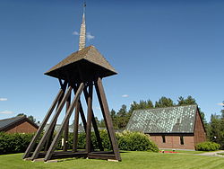
50:
80:
31:
371:
87:
57:
304:
is the biggest employer in the locality. In the school in Obbola there are pupils from grade one to grade nine. After that most of the pupils continue in the city of Umeå.
402:
569:
345:
605:
395:
35:
584:
610:
388:
559:
579:
112:
49:
380:
301:
452:
337:
256:
79:
180:
375:
419:
277:
173:
411:
269:
235:
245:
415:
273:
185:
8:
156:
30:
168:
341:
447:
293:
410:
161:
599:
517:
507:
312:
127:
114:
574:
472:
442:
522:
492:
564:
543:
538:
527:
487:
477:
297:
502:
462:
457:
289:
226:
512:
338:"Tätorternas landareal, folkmängd och invånare per km 2005 och 2010"
467:
437:
308:
285:
284:
with 2,197 inhabitants in 2010. It is located close to the town of
497:
144:
532:
423:
370:
281:
252:
231:
149:
315:which carries the E12 road over the river estuary.
597:
396:
403:
389:
288:. Obbola lies to the west of the mouth of
598:
606:Populated places in Umeå Municipality
384:
332:
330:
328:
348:from the original on 27 January 2012
200:2.56 km (0.99 sq mi)
13:
611:Coastal cities and towns in Sweden
325:
14:
622:
364:
369:
85:
78:
55:
48:
29:
307:Obbola is connected to nearby
86:
56:
1:
318:
16:Place in Västerbotten, Sweden
7:
10:
627:
552:
430:
242:
225:
221:858/km (2,220/sq mi)
217:
209:
204:
196:
191:
179:
167:
155:
143:
108:
42:
28:
21:
69:Show map of Västerbotten
378:at Wikimedia Commons
244: • Summer (
344:. 14 December 2011.
218: • Density
420:Västerbotten County
278:Västerbotten County
174:Västerbotten County
124: /
210: • Total
197: • Total
99:Show map of Sweden
593:
592:
416:Umeå Municipality
374:Media related to
342:Statistics Sweden
274:Umeå Municipality
263:
262:
186:Umeå Municipality
128:63.700°N 20.317°E
618:
405:
398:
391:
382:
381:
373:
358:
357:
355:
353:
334:
249:
139:
138:
136:
135:
134:
129:
125:
122:
121:
120:
117:
100:
89:
88:
82:
70:
59:
58:
52:
33:
19:
18:
626:
625:
621:
620:
619:
617:
616:
615:
596:
595:
594:
589:
575:Brännland södra
548:
426:
409:
367:
362:
361:
351:
349:
336:
335:
326:
321:
294:Gulf of Bothnia
243:
132:
130:
126:
123:
118:
115:
113:
111:
110:
104:
103:
102:
101:
98:
97:
96:
95:
94:
90:
73:
72:
71:
68:
67:
66:
65:
64:
60:
38:
24:
17:
12:
11:
5:
624:
614:
613:
608:
591:
590:
588:
587:
582:
577:
572:
567:
562:
556:
554:
550:
549:
547:
546:
541:
536:
530:
525:
520:
515:
510:
505:
500:
495:
490:
485:
480:
475:
470:
465:
460:
455:
450:
445:
440:
434:
432:
428:
427:
408:
407:
400:
393:
385:
366:
365:External links
363:
360:
359:
340:(in Swedish).
323:
322:
320:
317:
261:
260:
250:
240:
239:
229:
223:
222:
219:
215:
214:
211:
207:
206:
202:
201:
198:
194:
193:
189:
188:
183:
177:
176:
171:
165:
164:
159:
153:
152:
147:
141:
140:
133:63.700; 20.317
106:
105:
92:
91:
84:
83:
77:
76:
75:
74:
62:
61:
54:
53:
47:
46:
45:
44:
43:
40:
39:
34:
26:
25:
22:
15:
9:
6:
4:
3:
2:
623:
612:
609:
607:
604:
603:
601:
586:
583:
581:
578:
576:
573:
571:
568:
566:
563:
561:
558:
557:
555:
551:
545:
542:
540:
537:
534:
531:
529:
526:
524:
521:
519:
516:
514:
511:
509:
506:
504:
501:
499:
496:
494:
491:
489:
486:
484:
481:
479:
476:
474:
471:
469:
466:
464:
461:
459:
456:
454:
451:
449:
446:
444:
441:
439:
436:
435:
433:
429:
425:
421:
417:
413:
406:
401:
399:
394:
392:
387:
386:
383:
379:
377:
372:
347:
343:
339:
333:
331:
329:
324:
316:
314:
313:Obbola Bridge
310:
305:
303:
299:
295:
291:
287:
283:
279:
275:
271:
267:
258:
254:
251:
247:
241:
237:
233:
230:
228:
224:
220:
216:
212:
208:
203:
199:
195:
190:
187:
184:
182:
178:
175:
172:
170:
166:
163:
160:
158:
154:
151:
148:
146:
142:
137:
109:Coordinates:
107:
81:
51:
41:
37:
36:Obbola Church
32:
27:
20:
482:
368:
350:. Retrieved
306:
272:situated in
265:
264:
181:Municipality
162:Västerbotten
131: /
600:Categories
478:Innertavle
431:Localities
412:Localities
352:10 January
319:References
298:Baltic Sea
205:Population
570:Bjännsjön
473:Hörnefors
458:Flurkmark
443:Brännland
290:Ume River
227:Time zone
585:Klabböle
565:Baggböle
553:Villages
544:Yttersjö
539:Västibyn
528:Tavelsjö
518:Stöcksjö
508:Sörmjöle
488:Överboda
468:Holmsund
448:Bullmark
438:Botsmark
346:Archived
309:Holmsund
286:Holmsund
270:locality
157:Province
560:Ansmark
503:Sörfors
463:Hissjön
453:Ersmark
311:by the
296:in the
292:at the
145:Country
119:20°19′E
116:63°42′N
580:Bodbyn
535:(seat)
523:Täfteå
513:Stöcke
493:Röbäck
483:Obbola
424:Sweden
376:Obbola
282:Sweden
266:Obbola
169:County
150:Sweden
93:Obbola
63:Obbola
23:Obbola
498:Sävar
268:is a
253:UTC+2
232:UTC+1
213:2,197
533:Umeå
354:2012
257:CEST
192:Area
414:in
302:SCA
246:DST
236:CET
602::
422:,
418:,
327:^
300:.
280:,
276:,
404:e
397:t
390:v
356:.
259:)
255:(
248:)
238:)
234:(
Text is available under the Creative Commons Attribution-ShareAlike License. Additional terms may apply.


