186:
193:
156:
613:
149:
336:
43:
418:
The island was inhabited in the middle of the first millennium BC by Bantu tribes from the mainland, who formed the Bubi ethnic group. Unlike other islands in the area, Bioko had an indigenous
African population. The Bubi speak a Bantu language. The island has probably been inhabited by this or other
331:
runs near the summit. All three shield volcanoes on Bioko Island are listed within the
Smithsonian Global Volcanism Program database of active volcanoes, though only Pico Basilé has erupted in historic times (most recently in 1923).
429:
The first ascent of the mountain by
Europeans was made by English commanders between 1827 and 1828 under the Owen expedition. Its first official ascent was made in 1839 by the British
316:. The very top is used as a broadcast transmitting station for RTVGE (Radio Television Guinea Ecuatorial) and microwave relay station for various communication networks.
529:
557:
654:
685:
104:
1082:
995:
694:
1102:
185:
1087:
1077:
985:
647:
678:
442:
1097:
1092:
875:
640:
86:
598:
671:
526:
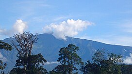
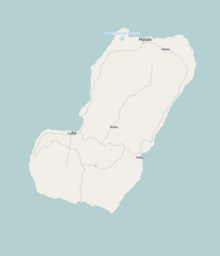
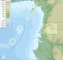
301:. With an elevation of 9,878 ft (3,011 m), it is the summit of the largest and highest of three overlapping
148:
97:
320:
259:
73:
547:
Pérez del Val, Jaime 1996. Las Aves de Bioko, Guinea
Ecuatorial: Guia de Campo. Edilesa, Léon, Spain.
780:
702:
586:
895:
591:
561:
247:
65:
910:
1051:
1021:
830:
820:
404:
368:
90:
628:
494:
8:
1010:
890:
81:
950:
920:
840:
620:
423:
298:
235:
1046:
960:
955:
945:
810:
730:
1000:
970:
930:
925:
905:
725:
533:
472:
825:
805:
612:
1072:
975:
870:
860:
760:
740:
624:
581:
508:(1). Consejo Superior de Investigaciones Científicas “Real Jardín Botánico”: 46
493:
Fero, Maximiliano; Cabezas, Francisco; Aedo, Carlos; Velayos, Mauricio (2003).
376:
356:
348:
305:
252:
1066:
965:
900:
865:
765:
447:
430:
388:
372:
344:
119:
106:
403:. Multiple range restricted species occur on Pico Basilé, and one bird, the
915:
845:
770:
745:
720:
663:
433:
who was later governor of the island that was once
Fernando Po, now Bioko.
309:
426:
was the first
European to sight the island while seeking a path to India.
1036:
885:
855:
850:
835:
750:
710:
324:
364:
1026:
800:
790:
755:
735:
715:
360:
1031:
775:
379:. The other island volcanoes to the SW of Bioko Island are extinct.
328:
312:
can be seen to the northeast. Pico Basilé lies close to the city of
396:
352:
335:
42:
395:
as a whole are similar to that of the montane regions of adjacent
940:
880:
815:
795:
400:
1041:
935:
313:
302:
55:
566:(in French). Peuples Noirs Peuples Africains. pp. 27–92.
392:
294:
231:
410:, is wholly restricted to the volcano's higher elevations.
419:
Bantu-speaking groups since before the 7th century BC.
492:
495:"Check-List of the Piperaceae of Equatorial Guinea"
355:. This line includes other volcanic islands in the
556:
1064:
527:Network for Protected areas in Equatorial Guinea
679:
648:
280:
271:
209:
199:
162:
31:
22:
693:
686:
672:
655:
641:
467:
465:
463:
323:, created in April 2000 The boundaries of
1052:Saint Helena, Ascension, Tristan da Cunha
391:, the flora and fauna of Pico Basilé and
334:
308:which form the island. From the summit,
460:
351:that runs from the Atlantic Ocean into
1065:
443:List of volcanoes in Equatorial Guinea
1083:Shield volcanoes of Equatorial Guinea
1032:French Southern & Antarctic Lands
667:
599:Bioko Biodiversity Protection Program
16:Tallest mountain of Equatorial Guinea
607:
502:Anales del Jardín Botánico de Madrid
486:
192:
155:
13:
422:In 1472, the Portuguese navigator
382:
14:
1114:
1103:Equatorial Guinea geography stubs
996:Sahrawi Arab Democratic Republic
766:Democratic Republic of the Congo
611:
191:
184:
172:Location of Pico Basilé in Bioko
154:
147:
41:
1088:Volcanoes of the Atlantic Ocean
563:Connaître la Guinée équatoriale
1078:Mountains of Equatorial Guinea
550:
541:
520:
1:
453:
347:, a major northeast-trending
297:, is the tallest mountain of
217:Show map of Equatorial Guinea
1098:Polygenetic shield volcanoes
1037:Heard & McDonald Islands
627:. You can help Knowledge by
293:), located on the island of
70:3,011 m (9,879 ft)
60:3,011 m (9,879 ft)
7:
1093:Highest points of countries
436:
343:Bioko was formed along the
10:
1119:
606:
574:
473:"Africa Ultra-Prominences"
413:
1009:
984:
701:
371:, along with the massive
321:Pico Basilé National Park
319:The peak forms a part of
272:
258:
246:
241:
227:
210:
200:
163:
140:
135:
96:
80:
64:
54:
49:
40:
30:
23:
21:
751:Central African Republic
695:Highest points of Africa
587:Global Volcanism Program
592:Smithsonian Institution
623:location article is a
340:
281:
32:
911:São Tomé and Príncipe
771:Republic of the Congo
338:
282:Pico de Santa Isabel
33:Pico de Santa Isabel
988:limited recognition
214:(Equatorial Guinea)
120:3.58333°N 8.76667°E
116: /
558:Max Liniger-Goumaz
532:2011-02-02 at the
341:
87:Country high point
50:Highest point
1060:
1059:
1015:other territories
786:Equatorial Guinea
636:
635:
621:Equatorial Guinea
407:Zoterops brunneus
299:Equatorial Guinea
268:
267:
236:Equatorial Guinea
175:Show map of Bioko
76:
1110:
703:Sovereign states
688:
681:
674:
665:
664:
657:
650:
643:
615:
608:
595:
568:
567:
554:
548:
545:
539:
538:
524:
518:
517:
515:
513:
499:
490:
484:
483:
481:
480:
469:
306:shield volcanoes
284:
275:
218:
213:
203:
195:
194:
188:
176:
166:
158:
157:
151:
131:
130:
128:
127:
126:
125:3.58333; 8.76667
121:
117:
114:
113:
112:
109:
72:
45:
35:
26:
19:
18:
1118:
1117:
1113:
1112:
1111:
1109:
1108:
1107:
1063:
1062:
1061:
1056:
1014:
1005:
987:
980:
697:
692:
662:
661:
604:
580:
577:
572:
571:
555:
551:
546:
542:
536:
534:Wayback Machine
525:
521:
511:
509:
497:
491:
487:
478:
476:
471:
470:
461:
456:
439:
416:
405:Bioko Speirops
385:
383:Flora and fauna
223:
222:
221:
220:
219:
216:
215:
207:
206:
205:
204:
196:
179:
178:
177:
174:
173:
170:
169:
168:
167:
159:
124:
122:
118:
115:
110:
107:
105:
103:
102:
89:
71:
36:, Clarence Peak
17:
12:
11:
5:
1116:
1106:
1105:
1100:
1095:
1090:
1085:
1080:
1075:
1058:
1057:
1055:
1054:
1049:
1044:
1039:
1034:
1029:
1024:
1018:
1016:
1007:
1006:
1004:
1003:
998:
992:
990:
982:
981:
979:
978:
973:
968:
963:
958:
953:
948:
943:
938:
933:
928:
923:
918:
913:
908:
903:
898:
893:
888:
883:
878:
873:
868:
863:
858:
853:
848:
843:
838:
833:
828:
823:
818:
813:
808:
803:
798:
793:
788:
783:
778:
773:
768:
763:
758:
753:
748:
743:
738:
733:
728:
723:
718:
713:
707:
705:
699:
698:
691:
690:
683:
676:
668:
660:
659:
652:
645:
637:
634:
633:
616:
602:
601:
596:
582:"Santa Isabel"
576:
573:
570:
569:
549:
540:
519:
485:
475:. Peaklist.org
458:
457:
455:
452:
451:
450:
445:
438:
435:
415:
412:
384:
381:
377:Mount Cameroon
357:Gulf of Guinea
349:geologic fault
266:
265:
262:
256:
255:
253:Shield volcano
250:
244:
243:
239:
238:
229:
225:
224:
208:
198:
197:
190:
189:
183:
182:
181:
180:
171:
161:
160:
153:
152:
146:
145:
144:
143:
142:
141:
138:
137:
133:
132:
100:
94:
93:
84:
78:
77:
68:
62:
61:
58:
52:
51:
47:
46:
38:
37:
28:
27:
15:
9:
6:
4:
3:
2:
1115:
1104:
1101:
1099:
1096:
1094:
1091:
1089:
1086:
1084:
1081:
1079:
1076:
1074:
1071:
1070:
1068:
1053:
1050:
1048:
1045:
1043:
1040:
1038:
1035:
1033:
1030:
1028:
1027:Bouvet Island
1025:
1023:
1020:
1019:
1017:
1012:
1008:
1002:
999:
997:
994:
993:
991:
989:
983:
977:
974:
972:
969:
967:
964:
962:
959:
957:
954:
952:
949:
947:
944:
942:
939:
937:
934:
932:
929:
927:
924:
922:
919:
917:
914:
912:
909:
907:
904:
902:
899:
897:
894:
892:
889:
887:
884:
882:
879:
877:
874:
872:
869:
867:
864:
862:
859:
857:
854:
852:
849:
847:
844:
842:
839:
837:
834:
832:
829:
827:
826:Guinea-Bissau
824:
822:
819:
817:
814:
812:
809:
807:
804:
802:
799:
797:
794:
792:
789:
787:
784:
782:
779:
777:
774:
772:
769:
767:
764:
762:
759:
757:
754:
752:
749:
747:
744:
742:
739:
737:
734:
732:
729:
727:
724:
722:
719:
717:
714:
712:
709:
708:
706:
704:
700:
696:
689:
684:
682:
677:
675:
670:
669:
666:
658:
653:
651:
646:
644:
639:
638:
632:
630:
626:
622:
617:
614:
610:
609:
605:
600:
597:
593:
589:
588:
583:
579:
578:
565:
564:
559:
553:
544:
535:
531:
528:
523:
507:
503:
496:
489:
474:
468:
466:
464:
459:
449:
448:Cameroon line
446:
444:
441:
440:
434:
432:
431:John Beecroft
427:
425:
420:
411:
409:
408:
402:
398:
394:
390:
389:Cameroon line
380:
378:
374:
373:stratovolcano
370:
366:
362:
358:
354:
350:
346:
345:Cameroon line
337:
333:
330:
326:
322:
317:
315:
311:
307:
304:
300:
296:
292:
291:
290:Clarence Peak
286:
285:
283:
276:
274:
263:
261:
260:Last eruption
257:
254:
251:
249:
248:Mountain type
245:
240:
237:
233:
230:
226:
212:
202:
187:
165:
150:
139:
134:
129:
101:
99:
95:
92:
88:
85:
83:
79:
75:
69:
67:
63:
59:
57:
53:
48:
44:
39:
34:
29:
25:
20:
1011:Dependencies
936:South Africa
926:Sierra Leone
785:
731:Burkina Faso
629:expanding it
618:
603:
585:
562:
552:
543:
522:
510:. Retrieved
505:
501:
488:
477:. Retrieved
428:
424:Fernão do Pó
421:
417:
406:
387:Part of the
386:
342:
318:
310:Mt. Cameroon
289:
288:
279:
278:
270:
269:
986:States with
941:South Sudan
831:Ivory Coast
537:(in French)
339:Pico Basilé
325:Bioko Norte
273:Pico Basilé
211:Pico Basilé
201:Pico Basilé
164:Pico Basilé
123: /
98:Coordinates
74:Ranked 90th
24:Pico Basilé
1067:Categories
1001:Somaliland
921:Seychelles
886:Mozambique
871:Mauritania
856:Madagascar
746:Cape Verde
479:2013-02-10
454:References
277:(formerly
66:Prominence
1022:Bir Tawil
876:Mauritius
796:Swaziland
512:15 August
136:Geography
111:8°46′00″E
108:3°35′00″N
56:Elevation
976:Zimbabwe
951:Tanzania
801:Ethiopia
776:Djibouti
741:Cameroon
726:Botswana
560:(1985).
530:Archived
437:See also
397:Cameroon
369:São Tomé
365:Príncipe
359:such as
353:Cameroon
303:basaltic
228:Location
1047:Réunion
1042:Mayotte
961:Tunisia
931:Somalia
916:Senegal
901:Nigeria
891:Namibia
881:Morocco
846:Liberia
841:Lesotho
791:Eritrea
761:Comoros
736:Burundi
711:Algeria
575:Sources
414:History
401:Nigeria
361:Annobón
242:Geology
82:Listing
971:Zambia
966:Uganda
906:Rwanda
861:Malawi
821:Guinea
811:Gambia
716:Angola
314:Malabo
1073:Bioko
946:Sudan
896:Niger
851:Libya
836:Kenya
816:Ghana
806:Gabon
781:Egypt
721:Benin
619:This
498:(PDF)
393:Bioko
295:Bioko
232:Bioko
91:Ultra
956:Togo
866:Mali
756:Chad
625:stub
514:2022
399:and
367:and
327:and
264:1923
1013:and
375:of
329:Sur
287:or
1069::
590:.
584:.
506:60
504:.
500:.
462:^
363:,
234:,
687:e
680:t
673:v
656:e
649:t
642:v
631:.
594:.
516:.
482:.
Text is available under the Creative Commons Attribution-ShareAlike License. Additional terms may apply.


