250:
29:
304:
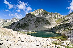
The river springs from the southern shore of the
Argirovo glacial lake in situated in the Demirkapia cirque in Northern Pirin at an altitude of 2,365 m. It flows in southern direction in a deep valley. Near Pirin refuge it turns to the southeast and enters a densely forested area, where it again
336:
The
Pirinska Bistritsa River has predominantly snow-rain feed with high water in late spring (May) and low water in late summer (September). The average annual flow is 3.35 m/s at the village of Pirin.
321:
is the confluence with the river
Petrovska reka. From that point it forms the border between Bulgaria and Greece until its confluence with the Struma at an altitude of 69 m between the villages of
293:. The river is 53 km long; the last 7 km before its confluence with the Struma forms the border between Bulgaria and Greece. Pirinska Bistritsa drains the south-western sections of the
171:
409:Мичев (Michev), Николай (Nikolay); Михайлов (Mihaylov), Цветко (Tsvetko); Вапцаров (Vaptsarov), Иван (Ivan); Кираджиев (Kiradzhiev), Светлин (Svetlin) (1980).
473:
95:
468:
478:
483:
453:
309:
the river takes a sharp turn to the southwest and enters a sparsely forested valley with eroded slopes. At the village of
448:
348:, Katuntsi and Novo Hodzhovo. The river's waters are utilised for irrigation and electrical power generation.
314:
458:
463:
306:
341:
298:
8:
249:
266:
28:
345:
333:
Its drainage basin covers a territory of 507 km or 2.93% of Struma's total.
488:
290:
274:
237:
156:
442:
318:
186:
173:
110:
97:
317:, where the river bed widens. At half a kilometer south of the village of
327:
141:
417:] (in Bulgarian). София (Sofia): Наука и култура (Nauka i kultura).
241:
33:
The source of
Pirinska Bistritsa at the southern shore of Argirovo Lake
371:
369:
367:
365:
363:
361:
340:
There are four settlements along the river, all of them situated in
358:
310:
282:
47:
408:
375:
323:
286:
51:
431:
294:
81:
253:
View from the upper reaches of the
Pirinska Bistritsa River
440:
297:mountain range and the northern sections of the
388:
386:
384:
381:
422:Душков (Dushkov), Добри (Dobri) (1972).
248:
421:
392:
441:
376:Geographic Dictionary of Bulgaria 1980
434:): Наука и култура (Nauka i kultura).
305:flows southwards. At the village of
474:Landforms of Serres (regional unit)
13:
14:
500:
469:Landforms of Blagoevgrad Province
415:Geographic Dictionary of Bulgaria
224:507 km (196 sq mi)
27:
479:Geography of Macedonia (region)
22:Pirinska Bistritsa, Mpístritsas
484:Landforms of Central Macedonia
454:International rivers of Europe
281:) is a river in south-western
165: • coordinates
89: • coordinates
1:
430:] (in Bulgarian). София (
411:Географски речник на България
402:
58:Physical characteristics
351:
204: • elevation
132:2,365 m (7,759 ft)
128: • elevation
7:
152: • location
76: • location
10:
505:
424:Пирин. Туристически речник
289:, a left tributary of the
449:Tributaries of the Struma
428:Pirin. Tourist Dictionary
278:
270:
233:
228:
220:
212:
202:
163:
150:
140:
136:
126:
111:41.6911000°N 23.5086000°E
87:
74:
66:
62:
57:
43:
38:
26:
21:
16:River in Bulgaria, Greece
315:Sandanski–Petrich Valley
216:53 km (33 mi)
208:69 m (226 ft)
187:41.36500°N 23.3422000°E
342:Sandanski Municipality
254:
116:41.6911000; 23.5086000
252:
192:41.36500; 23.3422000
229:Basin features
183: /
107: /
459:Rivers of Bulgaria
259:Pirinska Bistritsa
255:
271:Пиринска Бистрица
247:
246:
496:
464:Rivers of Greece
435:
418:
396:
390:
379:
373:
301:mountain range.
280:
272:
198:
197:
195:
194:
193:
188:
184:
181:
180:
179:
176:
129:
122:
121:
119:
118:
117:
112:
108:
105:
104:
103:
100:
90:
77:
31:
19:
18:
504:
503:
499:
498:
497:
495:
494:
493:
439:
438:
405:
400:
399:
391:
382:
374:
359:
354:
346:Gorno Spanchevo
205:
191:
189:
185:
182:
177:
174:
172:
170:
169:
166:
153:
127:
115:
113:
109:
106:
101:
98:
96:
94:
93:
88:
80:Argirovo Lake,
75:
34:
17:
12:
11:
5:
502:
492:
491:
486:
481:
476:
471:
466:
461:
456:
451:
437:
436:
419:
404:
401:
398:
397:
380:
356:
355:
353:
350:
313:it enters the
245:
244:
235:
231:
230:
226:
225:
222:
218:
217:
214:
210:
209:
206:
203:
200:
199:
167:
164:
161:
160:
154:
151:
148:
147:
144:
138:
137:
134:
133:
130:
124:
123:
91:
85:
84:
78:
72:
71:
68:
64:
63:
60:
59:
55:
54:
45:
41:
40:
36:
35:
32:
24:
23:
15:
9:
6:
4:
3:
2:
501:
490:
487:
485:
482:
480:
477:
475:
472:
470:
467:
465:
462:
460:
457:
455:
452:
450:
447:
446:
444:
433:
429:
425:
420:
416:
412:
407:
406:
395:, p. 126
394:
389:
387:
385:
377:
372:
370:
368:
366:
364:
362:
357:
349:
347:
343:
338:
334:
331:
329:
325:
320:
319:Novo Hodzhovo
316:
312:
308:
302:
300:
296:
292:
288:
285:and northern
284:
276:
268:
264:
260:
251:
243:
239:
236:
232:
227:
223:
219:
215:
211:
207:
201:
196:
178:23°20′31.92″E
168:
162:
158:
155:
149:
145:
143:
139:
135:
131:
125:
120:
102:23°30′30.96″E
99:41°41′27.96″N
92:
86:
83:
79:
73:
69:
65:
61:
56:
53:
49:
46:
42:
37:
30:
25:
20:
427:
423:
414:
410:
393:Dushkov 1972
378:, p. 48
339:
335:
332:
303:
262:
258:
256:
328:Promachonas
279:Μπίστριτσας
263:Mpístritsas
234:Progression
190: /
114: /
443:Categories
403:References
242:Aegean Sea
221:Basin size
175:41°21′54″N
352:Citations
344:: Pirin,
299:Slavyanka
267:Bulgarian
311:Katuntsi
283:Bulgaria
48:Bulgaria
39:Location
44:Country
324:Kulata
291:Struma
287:Greece
238:Struma
213:Length
157:Struma
146:
70:
67:Source
52:Greece
489:Pirin
432:Sofia
426:[
413:[
307:Pirin
295:Pirin
275:Greek
159:River
142:Mouth
82:Pirin
326:and
257:The
261:or
445::
383:^
360:^
330:.
277::
273:,
269::
240:→
50:,
265:(
Text is available under the Creative Commons Attribution-ShareAlike License. Additional terms may apply.

