176:
840:
164:
718:
695:
329:
707:
40:
378:
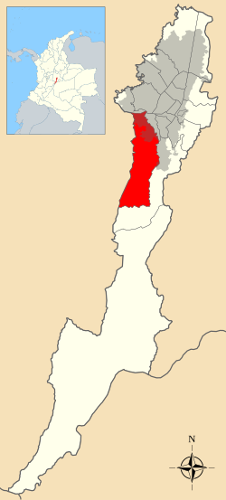
The locality of Ciudad Bolívar is 90% mountainous and has a total area of 229.14 square kilometres (88.47 sq mi), of which 20.88 square kilometres (8.06 sq mi) is urban, making it the 7th largest locality of Bogota. The locality is located in the southwestern part of the urban
474:
which were fractioned as a process of urbanization due to its proximity to the exploding Bogotá's urban development. The first neighborhoods were
Meissen, San Francisco, Buenos Aires, Lucero Bajo and La María which were populated by low income people; mainly immigrants from the neighboring
490:
A second urbanization stage started in the 1980s with settlements on the higher parts of the southern hills with neighborhoods as
Naciones Unidas, Cordillera, Alpes, Juan José Rondón, Juan Pablo II and others. The
522:
Some of the better known neighborhoods are: La
Estrella, El Paraíso, Lucero Alto, San Joaquín, Sierra Morena, San Francisco, Perdomo, Madelena, La Isla, Alto de La Cruz, Minuto de María and Francisco Pizarro.
428:
509:
Bogotá's
Special District was changed to a Capital District and Ciudad Bolívar became a locality with its own Local City hall and Local Administrative Junta (Council) with 11 councilmen.
436:
189:
1042:
455:
495:
also helped to develop the neighborhoods of Sierra Morena, Arborizadora Alta and Baja for low-income families which in less than 20 years generated areas of concentration.
175:
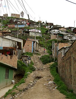
366:. Its urban area concentrates the poorest population in Bogotá and is known for its rampant levels of violence due to a large activity of gangs, mafia, and at times
536:
499:
657:
432:
356:
647:
1059:
104:
76:
163:
57:
17:
83:
662:
90:
652:
72:
1009:
613:
502:
which was designed to plan the area's development. On
September 14, 1983, the Minor City hall of Ciudad Bolívar was created.
237:
684:
702:
123:
1092:
1097:
492:
97:
625:
506:
61:
848:
819:
589:
804:
692:
447:
340:
749:
1037:
362:
While most Ciudad Bolívar's area is rural, its urban portion includes one of the world's largest mega-
839:
694:
319:
957:
814:
911:
476:
50:
677:
566:
881:
451:
706:
632:
1027:
1014:
866:
1047:
886:
601:
435:
is the main road for the neighborhoods located on the eastern side of the locality and the
150:
1064:
1032:
484:
8:
987:
744:
717:
487:. The rapid population growth in the area reached in the 1970s some 50,000 inhabitants.
462:
gondola lift opened in 2018 and serves the steep hill neighbourhoods of Ciudad Bolívar.
926:
1071:
769:
670:
384:
609:
480:
1004:
352:
28:
351:. Ciudad Bolívar is located in the south of the city at the southern border of the
977:
799:
784:
764:
380:
997:
962:
789:
392:
1086:
809:
204:
191:
936:
871:
992:
459:
443:
328:
27:
This article is about the locality in Bogotá. For the
Venezuelan city, see
906:
876:
982:
794:
779:
774:
967:
759:
431:
which crosses the locality from north to east in a diagonal sense. The
427:
There are very few neighborhoods with access to main roads besides the
412:
388:
734:
739:
395:
and the
Autopista Sur. To the west, it borders the municipalities of
302:
1052:
941:
901:
896:
856:
698:
400:
348:
154:
39:
539:
471:
344:
250:
829:
408:
916:
861:
552:
396:
931:
921:
891:
404:
307:
535:
located in Ciudad Bolívar are El
Mochuelo, located near the
379:
area of Bogota, bordering to the north with the locality of
754:
416:
367:
363:
180:
Location of the locality in the
Capital District of Bogotá
439:
which serves the neighborhoods of the southeastern part.
446:
covers Ciudad Bolívar in some areas with stops over the
64:. Unsourced material may be challenged and removed.
1084:
648:National University of Colombia; Ciudad Bolívar
456:Centro Comercial Paseo Villa del Río - Madelena
370:, the national ex-terrorist group of Colombia.
498:Since 1983 the Council of Bogotá designed the
168:Location of the locality in the city of Bogotá
678:
619:
512:
407:, to the south borders with the locality of
136:Locality of Bogotá in Bogotá D.C., Colombia
685:
671:
560:
470:During the 1950s, the area was formed by
124:Learn how and when to remove this message
327:
355:. This district is mostly inhabited by
14:
1085:
666:
411:, to the east with the localities of
62:adding citations to reliable sources
33:
24:
25:
1109:
641:
838:
716:
705:
693:
517:
268:130 km (50 sq mi)
174:
162:
38:
545:
493:Inter-American Development Bank
429:Avenida Ciudad de Villavicencio
49:needs additional citations for
658:lopublico.com – Ciudad Bolívar
608:, La Découverte, Paris, 2006 (
595:
580:
557:were found in Ciudad Bolívar.
507:Colombian Constitution of 1991
13:
1:
573:
422:
373:
339:is the 19th locality in the
297:4,600/km (12,000/sq mi)
276:2,600 m (8,500 ft)
7:
550:In 1987, fossil remains of
437:Avenida Jorge Gaitán Cortés
10:
1114:
526:
465:
26:
1023:
950:
847:
836:
723:
714:
513:Neighborhoods and veredas
314:
301:
293:
285:
280:
272:
264:
259:
236:
228:
220:
185:
173:
161:
148:
141:
442:The mass transit system
310:(Colombia Standard Time)
73:"Ciudad Bolívar, Bogotá"
1060:Conquest and foundation
653:Bogotá official website
18:Ciudad Bolívar (Bogotá)
1098:Slums in South America
569:, professional cyclist
561:Born in Ciudad Bolívar
333:
1065:Post-colonial history
633:Paleobiology Database
331:
1093:Localities of Bogotá
567:Miguel Ángel Rubiano
294: • Density
205:4.53611°N 74.13889°W
58:improve this article
500:Ciudad Bolívar Plan
201: /
820:Rafael Uribe Uribe
334:
286: • Total
265: • Total
210:4.53611; -74.13889
1080:
1079:
1043:First inhabitants
849:Metropolitan Area
628:Etayoa bacatensis
614:978-2-7071-4915-2
326:
325:
134:
133:
126:
108:
16:(Redirected from
1105:
842:
728:in 20 localities
720:
709:
703:Capital District
697:
687:
680:
673:
664:
663:
635:
623:
617:
599:
593:
588:
584:
393:Tunjuelito River
357:under privileged
341:Capital District
322:
320:Official website
216:
215:
213:
212:
211:
206:
202:
199:
198:
197:
194:
178:
166:
139:
138:
129:
122:
118:
115:
109:
107:
66:
42:
34:
21:
1113:
1112:
1108:
1107:
1106:
1104:
1103:
1102:
1083:
1082:
1081:
1076:
1019:
946:
843:
834:
727:
725:
721:
710:
691:
644:
639:
638:
626:Description of
624:
620:
606:Planet of Slums
600:
596:
590:Population 2007
586:
585:
581:
576:
563:
548:
542:and Pasquilla.
529:
520:
515:
468:
425:
376:
318:
255:
247:
246:
209:
207:
203:
200:
195:
192:
190:
188:
187:
181:
169:
157:
144:
137:
130:
119:
113:
110:
67:
65:
55:
43:
32:
23:
22:
15:
12:
11:
5:
1111:
1101:
1100:
1095:
1078:
1077:
1075:
1074:
1069:
1068:
1067:
1062:
1057:
1056:
1055:
1045:
1040:
1030:
1024:
1021:
1020:
1018:
1017:
1012:
1007:
1002:
1001:
1000:
995:
990:
985:
975:
972:
971:
970:
965:
954:
952:
948:
947:
945:
944:
939:
934:
929:
924:
919:
914:
909:
904:
899:
894:
889:
884:
879:
874:
869:
864:
859:
853:
851:
845:
844:
837:
835:
833:
832:
827:
825:Ciudad Bolívar
822:
817:
812:
807:
805:Antonio Nariño
802:
797:
792:
790:Barrios Unidos
787:
782:
777:
772:
767:
762:
757:
752:
747:
742:
737:
731:
729:
724:Administrative
722:
715:
712:
711:
690:
689:
682:
675:
667:
661:
660:
655:
650:
643:
642:External links
640:
637:
636:
618:
594:
578:
577:
575:
572:
571:
570:
562:
559:
547:
544:
528:
525:
519:
516:
514:
511:
467:
464:
448:Caracas Avenue
433:Avenida Boyacá
424:
421:
375:
372:
353:Bogotá savanna
337:Ciudad Bolívar
332:Ciudad Bolívar
324:
323:
316:
312:
311:
305:
299:
298:
295:
291:
290:
287:
283:
282:
278:
277:
274:
270:
269:
266:
262:
261:
257:
256:
254:
253:
244:
243:
242:
240:
238:Neighbourhoods
234:
233:
230:
226:
225:
222:
218:
217:
183:
182:
179:
171:
170:
167:
159:
158:
149:
146:
145:
143:Ciudad Bolívar
142:
135:
132:
131:
46:
44:
37:
29:Ciudad Bolívar
9:
6:
4:
3:
2:
1110:
1099:
1096:
1094:
1091:
1090:
1088:
1073:
1070:
1066:
1063:
1061:
1058:
1054:
1051:
1050:
1049:
1046:
1044:
1041:
1039:
1036:
1035:
1034:
1031:
1029:
1026:
1025:
1022:
1016:
1013:
1011:
1008:
1006:
1003:
999:
996:
994:
991:
989:
988:Juan Amarillo
986:
984:
981:
980:
979:
976:
973:
969:
966:
964:
961:
960:
959:
958:Eastern Hills
956:
955:
953:
949:
943:
940:
938:
935:
933:
930:
928:
925:
923:
920:
918:
915:
913:
910:
908:
905:
903:
900:
898:
895:
893:
890:
888:
885:
883:
880:
878:
875:
873:
870:
868:
865:
863:
860:
858:
855:
854:
852:
850:
846:
841:
831:
828:
826:
823:
821:
818:
816:
815:La Candelaria
813:
811:
810:Puente Aranda
808:
806:
803:
801:
798:
796:
793:
791:
788:
786:
783:
781:
778:
776:
773:
771:
768:
766:
763:
761:
758:
756:
753:
751:
750:San Cristóbal
748:
746:
743:
741:
738:
736:
733:
732:
730:
719:
713:
708:
704:
700:
696:
688:
683:
681:
676:
674:
669:
668:
665:
659:
656:
654:
651:
649:
646:
645:
634:
630:
629:
622:
615:
611:
607:
603:
598:
591:
583:
579:
568:
565:
564:
558:
556:
554:
543:
541:
538:
534:
524:
518:Neighborhoods
510:
508:
503:
501:
496:
494:
488:
486:
482:
478:
473:
463:
461:
457:
453:
449:
445:
440:
438:
434:
430:
420:
418:
414:
410:
406:
402:
398:
394:
390:
386:
382:
371:
369:
365:
360:
358:
354:
350:
347:capital city
346:
342:
338:
330:
321:
317:
313:
309:
306:
304:
300:
296:
292:
288:
284:
279:
275:
271:
267:
263:
258:
252:
249:
248:
241:
239:
235:
231:
227:
223:
219:
214:
186:Coordinates:
184:
177:
172:
165:
160:
156:
152:
147:
140:
128:
125:
117:
114:December 2017
106:
103:
99:
96:
92:
89:
85:
82:
78:
75: –
74:
70:
69:Find sources:
63:
59:
53:
52:
47:This article
45:
41:
36:
35:
30:
19:
1010:TvdH Reserve
978:Bogotá River
824:
800:Los Mártires
627:
621:
605:
597:
587:(in Spanish)
582:
551:
549:
546:Paleontology
532:
531:Some of the
530:
521:
504:
497:
489:
469:
460:TransMiCable
444:TransMilenio
441:
426:
377:
361:
336:
335:
120:
111:
101:
94:
87:
80:
68:
56:Please help
51:verification
48:
795:Teusaquillo
726:subdivision
477:Departments
359:residents.
232:Bogotá D.C.
208: /
1087:Categories
1072:Categories
1038:Prehistory
974:Suba Hills
968:Monserrate
937:Gachancipá
872:Facatativá
760:Tunjuelito
602:Mike Davis
574:References
555:bacatensis
537:Doña Juana
413:Tunjuelito
389:Tunjuelito
281:Population
196:74°08′20″W
84:newspapers
963:Guadalupe
951:Geography
912:La Calera
907:Tocancipá
877:Zipaquirá
740:Chapinero
616:), p. 31.
505:With the
472:haciendas
423:Transport
374:Geography
345:Colombian
303:Time zone
273:Elevation
193:4°32′10″N
1028:Timeline
1015:Wetlands
998:Tunjuelo
882:Mosquera
780:Engativá
775:Fontibón
745:Santa Fe
540:landfill
251:Madelena
224:Colombia
151:Locality
1033:History
1005:Savanna
830:Sumapaz
770:Kennedy
735:Usaquén
533:veredas
527:Veredas
466:History
452:Perdomo
409:Sumapaz
391:by the
385:Kennedy
343:of the
315:Website
289:593,937
221:Country
98:scholar
1053:Bacatá
1048:Muisca
993:Soacha
942:Bojacá
902:Sibaté
897:Cajicá
887:Madrid
862:Soacha
857:Bogotá
699:Bogotá
612:
592:– DANE
553:Etayoa
485:Boyacá
481:Tolima
401:Sibaté
397:Soacha
349:Bogotá
155:Bogotá
100:
93:
86:
79:
71:
983:Fucha
932:Tenjo
922:Tabio
892:Funza
405:Pasca
364:slums
308:UTC-5
105:JSTOR
91:books
927:Cota
917:Sopó
867:Chía
785:Suba
765:Bosa
755:Usme
610:ISBN
454:and
417:Usme
415:and
403:and
387:and
381:Bosa
368:FARC
260:Area
245:List
229:City
77:news
479:of
450:in
153:of
60:by
1089::
701:,
631:–
604:,
483:,
458:.
419:.
399:,
383:,
686:e
679:t
672:v
127:)
121:(
116:)
112:(
102:·
95:·
88:·
81:·
54:.
31:.
20:)
Text is available under the Creative Commons Attribution-ShareAlike License. Additional terms may apply.


