43:
584:"}},"text\/plain":{"en":{"":"inception"}}},"{\"value\":{\"time\":\"+2010-07-19T00:00:00Z\",\"timezone\":0,\"before\":0,\"after\":0,\"precision\":11,\"calendarmodel\":\"http:\\\/\\\/www.wikidata.org\\\/entity\\\/Q1985727\"},\"type\":\"time\"}":{"text\/html":{"en":{"P571":"19 July 2010"}},"text\/plain":{"en":{"P571":"19 July 2010"}}}}": -->
291:
319:
261:
325:
330:
99:
540:"}},"text\/plain":{"en":{"":"copyright license"}}},"{\"value\":{\"entity-type\":\"item\",\"numeric-id\":14946043,\"id\":\"Q14946043\"},\"type\":\"wikibase-entityid\"}":{"text\/html":{"en":{"P275":"
496:"}},"text\/plain":{"en":{"":"copyright status"}}},"{\"value\":{\"entity-type\":\"item\",\"numeric-id\":50423863,\"id\":\"Q50423863\"},\"type\":\"wikibase-entityid\"}":{"text\/html":{"en":{"P6216":"
691:
492:
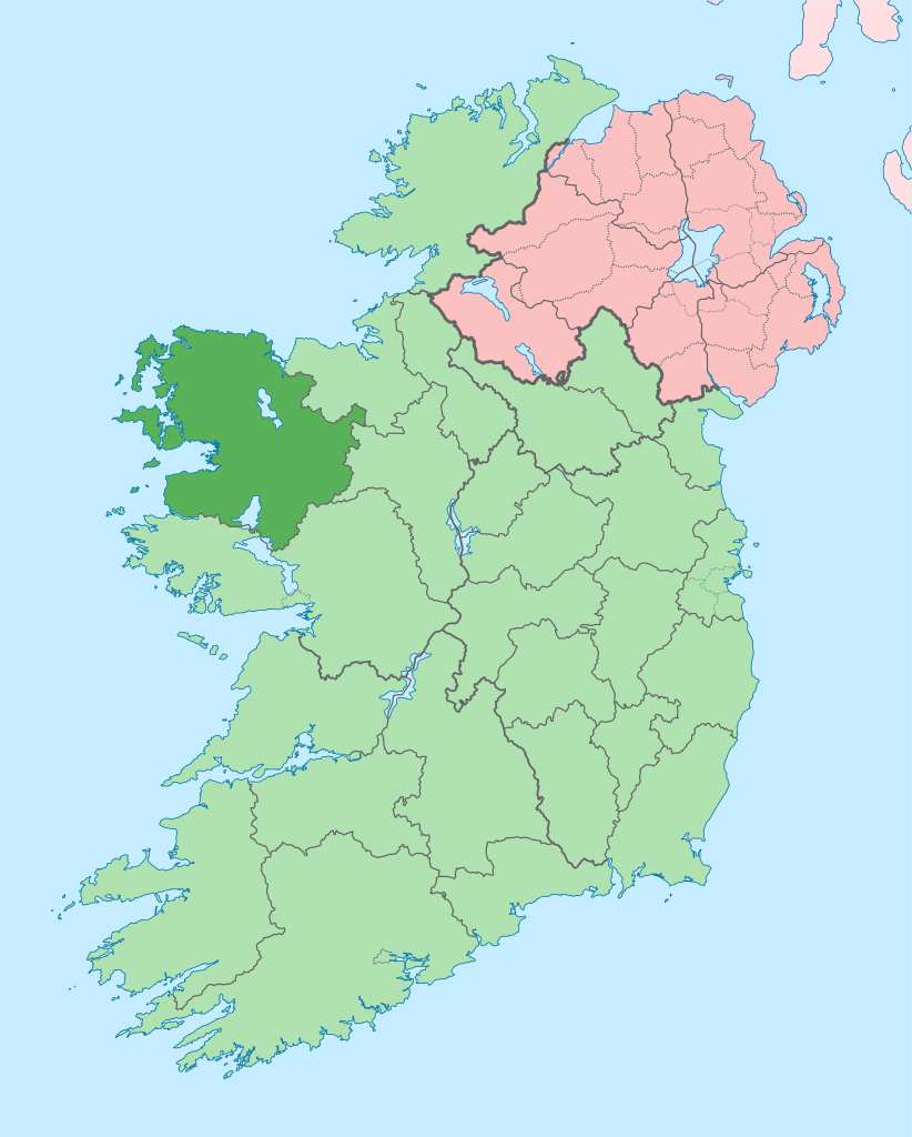
708:{{Information |Description={{en|The island of Ireland, showing international border between Northern Ireland and Republic of Ireland, traditional provinces, traditional counties, and local authority areas in the Republic of Ireland and Northern Ireland.}}
677:
Per the Local
Government Reform Act 2014, joining both Tipperarys and both Waterfords (and removing Limerick City code). Colouring in islands, cleaning up and grouping code to remove stray objects and show Galway and Lough
371:– You must give appropriate credit, provide a link to the license, and indicate if changes were made. You may do so in any reasonable manner, but not in any way that suggests the licensor endorses you or your use.
437:{{Information |Description={{de|Positionskarte von ]}} Quadratische Plattkarte, N-S-Streckung 170 %. Geographische Begrenzung der Karte: * N: 55.6° N * S: 51.2° N * W: 11.0° W * O: 5.0° W {{en|Location
148:
The island of
Ireland, showing international border between Ireland and Northern Ireland, traditional provinces, traditional counties, and local authority areas in Ireland and Northern Ireland.
1228:
719:
541:
497:
301:
1565:
493:
581:
537:
73:
69:
65:
61:
57:
53:
47:
1216:
1211:
1206:
110:
82:
1201:
1221:
544:"}},"text\/plain":{"en":{"P275":"Creative Commons Attribution-ShareAlike 3.0 Unported"}}}}": -->
1031:
415:
285:
184:
170:
690:
685:
1061:
197:
567:
523:
225:
206:
1576:
This file contains additional information, probably added from the digital camera or scanner used to create or digitize it.
378:
1286:
507:
591:
551:
482:
1071:
1066:
1076:
432:
422:
221:
188:
340:
1036:
1026:
1579:
If the file has been modified from its original state, some details may not fully reflect the modified file.
1266:
1041:
718:
More than 100 pages use this file. The following list shows the first 100 pages that use this file only. A
1256:
659:
654:
42:
377:– If you remix, transform, or build upon the material, you must distribute your contributions under the
500:"}},"text\/plain":{"en":{"P6216":"copyrighted"}}}}": -->
1166:
836:
118:
1011:
986:
771:
1086:
811:
736:
446:
1081:
931:
337:
279:, which means that it has been digitally altered from its original version. Modifications:
8:
1181:
1126:
906:
881:
841:
746:
1151:
1091:
896:
791:
670:
238:
201:
192:
996:
941:
871:
866:
856:
756:
105:
472:
312:
I, the copyright holder of this work, hereby publish it under the following license:
1136:
1111:
1106:
1096:
290:
1461:
781:
731:
271:
214:
210:
1156:
1021:
991:
861:
786:
296:
234:
1486:
1196:
1116:
1056:
826:
761:
726:
701:
601:
561:
517:
260:
1161:
1131:
1046:
971:
966:
961:
921:
901:
891:
886:
831:
776:
1051:
976:
926:
741:
981:
956:
876:
801:
796:
766:
1371:
1556:
1366:
1191:
1186:
1146:
1121:
1016:
1001:
951:
846:
806:
627:
Click on a date/time to view the file as it appeared at that time.
1311:
1176:
1376:
1276:
1141:
1006:
851:
821:
816:
1531:
1471:
1451:
1171:
1101:
946:
916:
911:
751:
157:
1466:
1341:
936:
87:(SVG file, nominally 1,450 × 1,807 pixels, file size: 642 KB)
1526:
1351:
1336:
1321:
1246:
1541:
1516:
1381:
1346:
1296:
1396:
1331:
1326:
1506:
1496:
1476:
1411:
411:
This image is a derivative work of the following images:
93:
1416:
1386:
1361:
1356:
1551:
1481:
1441:
1426:
1406:
1301:
1217:
Knowledge:Neutral point of view/Noticeboard/Archive 17
281:
Coloured in regions with county of article highlighted
1431:
716:
1421:
1401:
1316:
1237:
1212:
Knowledge:Graphics Lab/Map workshop/Archive/Oct 2014
1207:
Knowledge:Graphics Lab/Map workshop/Archive/May 2020
625:
568:
Creative
Commons Attribution-ShareAlike 3.0 Unported
542:
Creative
Commons Attribution-ShareAlike 3.0 Unported
117:
Commons is a freely licensed media file repository.
1456:
1391:
1306:
1202:Knowledge:Graphics Lab/Map workshop/Archive/2016
1222:Knowledge talk:WikiProject Geography/Archive 5
388:https://creativecommons.org/licenses/by-sa/3.0
98:
394:Creative Commons Attribution-Share Alike 3.0
318:
153:
135:
178:
164:
14:
354:– to copy, distribute and transmit the work
46:Size of this PNG preview of this SVG file:
1032:List of mountains and hills of County Mayo
1239:The following other wikis use this file:
283:. The original can be viewed here:
1062:Mayo Intermediate Football Championship
416:File:Island_of_Ireland_location_map.svg
138:Island of Ireland location map Mayo.svg
406:
129:
341:Attribution-Share Alike 3.0 Unported
254:
618:
329:
324:
272:
270:
13:
1574:
471:
465:
315:
311:
286:Island of Ireland location map.svg
185:Island_of_Ireland_location_map.svg
171:Island_of_Ireland_location_map.svg
142:
130:
80:
1608:
1581:
1072:Mayo Senior Football Championship
1067:Mayo Junior Football Championship
470:
198:Northern_Ireland_location_map.svg
1462:Wikipedista:Draceane/Plány/Irsko
1077:Mayo Senior Hurling Championship
456:
427:Fix incorrectly coloured isands.
365:Under the following conditions:
336:This file is licensed under the
328:
323:
317:
289:
259:
97:
31:
21:
453:
207:Northern_Ireland_-_Counties.png
143:
1234:
622:
452:
26:
1:
1037:List of rivers of County Mayo
1027:List of loughs of County Mayo
36:
1042:List of roads of County Mayo
713:
478:Items portrayed in this file
7:
1571:
1503:Usage on en.wikivoyage.org
1493:Usage on de.wikivoyage.org
1438:Usage on ceb.wikipedia.org
1273:Usage on ast.wikipedia.org
1263:Usage on arz.wikipedia.org
1243:Usage on ang.wikipedia.org
418:licensed with Cc-by-sa-3.0
10:
1613:
1548:Usage on eu.wikipedia.org
1538:Usage on et.wikipedia.org
1523:Usage on es.wikipedia.org
1513:Usage on eo.wikipedia.org
1448:Usage on cs.wikipedia.org
1293:Usage on ca.wikipedia.org
1283:Usage on bg.wikipedia.org
1253:Usage on ar.wikipedia.org
379:same or compatible license
132:
619:
435:1450x1807 (679744 Bytes)
425:1450x1807 (679207 Bytes)
16:
455:
345:
295:. Modifications made by
189:Ireland_location_map.svg
104:This is a file from the
41:
1167:Sraheens, Achill Island
837:Castlehill, County Mayo
707:
676:
156:
108:. Information from its
1012:Knockmore, County Mayo
987:Irishtown, County Mayo
772:Ballycroy, County Mayo
111:description page there
1487:Šablona:Hrabství Mayo
1312:Plantilla:Comtat Mayo
1087:Michael Davitt Bridge
812:Black River (Ireland)
737:Aghamore, County Mayo
433:Rannpháirtí anaithnid
431:2010-03-03T22:19:29Z
423:Rannpháirtí anaithnid
421:2010-03-06T20:43:33Z
222:Rannpháirtí anaithnid
211:Maximilian Dörrbecker
1082:Meelick, County Mayo
932:Drummin, County Mayo
74:1,450 × 1,807 pixels
70:1,643 × 2,048 pixels
1532:Condados de Irlanda
1182:Templenagalliaghdoo
1127:R335 road (Ireland)
907:Delphi, County Mayo
882:Corroy, County Mayo
842:Charlestown-Bellahy
747:Ardagh, County Mayo
686:00:58, 19 July 2010
655:14:01, 28 June 2020
407:Original upload log
360:– to adapt the work
158:19 July 2010, 00:55
52:Other resolutions:
1472:Louisburgh (Irsko)
1372:Béal an Mhuirthead
1152:Sheean, Islandeady
1092:N84 road (Ireland)
897:Cross, County Mayo
792:Bekan, County Mayo
66:822 × 1,024 pixels
1600:
1599:
1566:more global usage
1557:Tuar Mhic Éadaigh
1367:Tuar Mhic Éadaigh
1235:Global file usage
997:Keel, County Mayo
942:Fahy, County Mayo
872:Corraveggaun West
867:Corraun Peninsula
857:Collanmore Island
757:Balla Round Tower
711:
552:copyright license
538:copyright license
464:
308:
307:
273:retouched picture
249:
248:
233:derivative work:
220:derivative work:
126:
125:
106:Wikimedia Commons
32:Global file usage
1604:
1582:
1467:Westport (Irsko)
1342:Bun an Churraigh
1137:Rockfleet Castle
1112:Pollagh (Achill)
1107:Partry Mountains
1097:Nephin Beg Range
698:
667:
629:
508:copyright status
494:copyright status
462:
401:
398:
395:
392:
389:
381:as the original.
338:Creative Commons
332:
331:
327:
326:
321:
320:
303:
293:
276:
274:
263:
255:
241:
228:
159:
147:
139:
133:
122:
101:
100:
94:
88:
77:
62:616 × 768 pixels
58:385 × 480 pixels
54:192 × 240 pixels
48:481 × 599 pixels
1612:
1611:
1607:
1606:
1605:
1603:
1602:
1601:
1570:
1527:Condado de Mayo
1377:Ceathrú Thaidhg
1322:Westport (Mayo)
1287:Мейо (графство)
1233:
782:Ballymore Lough
732:Aghalard Castle
712:
704:
696:
673:
665:
621:
620:
617:
616:
615:
614:
613:
612:
611:
610:
608:
598:
597:
596:
594:
579:
578:
577:
576:
575:
574:
573:
572:
570:
558:
557:
556:
554:
535:
534:
533:
532:
531:
530:
529:
528:
526:
514:
513:
512:
510:
491:
490:
489:
488:
487:
485:
469:
468:
467:
409:
404:
403:
402:
399:
396:
393:
390:
387:
386:
344:
333:
314:
313:
264:
250:
239:
226:
149:
137:
128:
127:
116:
115:
114:is shown below.
90:
86:
79:
78:
51:
12:
11:
5:
1610:
1598:
1597:
1594:
1590:
1589:
1586:
1573:
1568:of this file.
1562:
1561:
1560:
1559:
1554:
1546:
1545:
1544:
1542:Mayo krahvkond
1536:
1535:
1534:
1529:
1521:
1520:
1519:
1517:Graflando Mayo
1511:
1510:
1509:
1501:
1500:
1499:
1491:
1490:
1489:
1484:
1479:
1474:
1469:
1464:
1459:
1454:
1446:
1445:
1444:
1436:
1435:
1434:
1429:
1424:
1419:
1414:
1409:
1404:
1399:
1394:
1389:
1384:
1382:Gleann an Ghad
1379:
1374:
1369:
1364:
1359:
1354:
1349:
1344:
1339:
1334:
1329:
1324:
1319:
1314:
1309:
1304:
1299:
1297:Comtat de Mayo
1291:
1290:
1289:
1281:
1280:
1279:
1277:Condáu de Mayo
1271:
1270:
1269:
1261:
1260:
1259:
1251:
1250:
1249:
1236:
1231:to this file.
1225:
1224:
1219:
1214:
1209:
1204:
1199:
1194:
1189:
1184:
1179:
1174:
1169:
1164:
1159:
1154:
1149:
1144:
1139:
1134:
1129:
1124:
1119:
1114:
1109:
1104:
1099:
1094:
1089:
1084:
1079:
1074:
1069:
1064:
1059:
1054:
1049:
1044:
1039:
1034:
1029:
1024:
1019:
1014:
1009:
1004:
999:
994:
989:
984:
979:
974:
969:
964:
959:
954:
949:
944:
939:
934:
929:
924:
919:
914:
909:
904:
899:
894:
889:
884:
879:
874:
869:
864:
859:
854:
849:
844:
839:
834:
829:
824:
819:
814:
809:
804:
799:
794:
789:
784:
779:
774:
769:
764:
759:
754:
749:
744:
739:
734:
729:
722:is available.
715:
710:
709:
706:
702:
699:
695:1,450 × 1,807
693:
688:
683:
680:
679:
675:
671:
668:
664:1,450 × 1,807
662:
657:
652:
648:
647:
644:
641:
638:
635:
632:
624:
609:
606:
604:
603:
602:
600:
599:
595:
590:
588:
587:
586:
585:
583:
571:
566:
564:
563:
562:
560:
559:
555:
550:
548:
547:
546:
545:
543:
539:
527:
522:
520:
519:
518:
516:
515:
511:
506:
504:
503:
502:
501:
499:
495:
486:
481:
479:
476:
475:
474:
473:
461:
460:
457:
454:
445:Uploaded with
442:
441:
440:
439:
429:
408:
405:
385:
384:
383:
382:
372:
363:
362:
361:
355:
348:You are free:
335:
334:
316:
310:
309:
306:
305:
265:
258:
247:
246:
245:
244:
231:
218:
204:
195:
180:
176:
175:
174:
173:
166:
162:
161:
155:
151:
150:
140:
131:
124:
123:
102:
92:
91:
45:
40:
39:
34:
29:
24:
19:
9:
6:
4:
3:
2:
1609:
1595:
1592:
1591:
1587:
1584:
1583:
1580:
1577:
1569:
1567:
1558:
1555:
1553:
1550:
1549:
1547:
1543:
1540:
1539:
1537:
1533:
1530:
1528:
1525:
1524:
1522:
1518:
1515:
1514:
1512:
1508:
1505:
1504:
1502:
1498:
1495:
1494:
1492:
1488:
1485:
1483:
1480:
1478:
1475:
1473:
1470:
1468:
1465:
1463:
1460:
1458:
1455:
1453:
1452:Hrabství Mayo
1450:
1449:
1447:
1443:
1440:
1439:
1437:
1433:
1430:
1428:
1425:
1423:
1420:
1418:
1415:
1413:
1410:
1408:
1405:
1403:
1400:
1398:
1397:Illa de Clare
1395:
1393:
1390:
1388:
1385:
1383:
1380:
1378:
1375:
1373:
1370:
1368:
1365:
1363:
1360:
1358:
1355:
1353:
1350:
1348:
1345:
1343:
1340:
1338:
1335:
1333:
1330:
1328:
1327:Gob an Choire
1325:
1323:
1320:
1318:
1315:
1313:
1310:
1308:
1305:
1303:
1300:
1298:
1295:
1294:
1292:
1288:
1285:
1284:
1282:
1278:
1275:
1274:
1272:
1268:
1265:
1264:
1262:
1258:
1255:
1254:
1252:
1248:
1245:
1244:
1242:
1241:
1240:
1232:
1230:
1223:
1220:
1218:
1215:
1213:
1210:
1208:
1205:
1203:
1200:
1198:
1195:
1193:
1190:
1188:
1185:
1183:
1180:
1178:
1175:
1173:
1170:
1168:
1165:
1163:
1160:
1158:
1157:Shrule Castle
1155:
1153:
1150:
1148:
1145:
1143:
1140:
1138:
1135:
1133:
1130:
1128:
1125:
1123:
1120:
1118:
1115:
1113:
1110:
1108:
1105:
1103:
1100:
1098:
1095:
1093:
1090:
1088:
1085:
1083:
1080:
1078:
1075:
1073:
1070:
1068:
1065:
1063:
1060:
1058:
1055:
1053:
1050:
1048:
1045:
1043:
1040:
1038:
1035:
1033:
1030:
1028:
1025:
1023:
1022:Levally Lough
1020:
1018:
1015:
1013:
1010:
1008:
1005:
1003:
1000:
998:
995:
993:
992:Joyce Country
990:
988:
985:
983:
980:
978:
975:
973:
970:
968:
965:
963:
960:
958:
955:
953:
950:
948:
945:
943:
940:
938:
935:
933:
930:
928:
925:
923:
920:
918:
915:
913:
910:
908:
905:
903:
900:
898:
895:
893:
890:
888:
885:
883:
880:
878:
875:
873:
870:
868:
865:
863:
862:Corranabinnia
860:
858:
855:
853:
850:
848:
845:
843:
840:
838:
835:
833:
830:
828:
825:
823:
820:
818:
815:
813:
810:
808:
805:
803:
800:
798:
795:
793:
790:
788:
787:Barrclashcame
785:
783:
780:
778:
775:
773:
770:
768:
765:
763:
760:
758:
755:
753:
750:
748:
745:
743:
740:
738:
735:
733:
730:
728:
725:
724:
723:
721:
705:
700:
694:
692:
689:
687:
684:
682:
681:
674:
672:Chipmunkdavis
669:
663:
661:
658:
656:
653:
650:
649:
645:
642:
639:
636:
633:
631:
630:
628:
605:
593:
589:
569:
565:
553:
549:
525:
521:
509:
505:
484:
480:
477:
466:Mayo on a map
458:
451:
450:
449:
448:
438:
434:
430:
428:
424:
420:
419:
417:
414:
413:
412:
391:CC BY-SA 3.0
380:
376:
373:
370:
367:
366:
364:
359:
356:
353:
350:
349:
347:
346:
342:
339:
322:
304:
298:
294:
292:
287:
282:
278:
277:
275:
266:
262:
257:
256:
253:
252:
242:
236:
232:
229:
223:
219:
216:
212:
208:
205:
203:
199:
196:
194:
190:
186:
183:
182:
181:
177:
172:
169:
168:
167:
163:
152:
146:
141:
134:
120:
113:
112:
107:
103:
96:
95:
89:
84:
83:Original file
75:
71:
67:
63:
59:
55:
49:
44:
38:
35:
33:
30:
28:
25:
23:
20:
18:
15:
1578:
1575:
1563:
1477:Clare Island
1412:Bangor Erris
1238:
1226:
1197:Uggool Beach
1117:Pollatoomary
1057:Lough Feeagh
827:Caher Island
762:Ballintubber
727:Achill Sound
717:
626:
623:File history
607:19 July 2010
447:derivativeFX
444:
443:
436:
426:
410:
374:
368:
357:
351:
300:
284:
280:
269:
268:
251:
202:NordNordWest
193:NordNordWest
144:
119:You can help
109:
81:
22:File history
1507:County Mayo
1497:County Mayo
1417:Crossmolina
1387:Ros Dumhach
1267:كاونتى مايو
1257:مقاطعة مايو
1162:Slieve Carr
1132:River Clare
1047:Lough Carra
972:Inishcottle
967:Inishbiggle
962:Illanmaster
922:Doon Castle
902:Cross Lough
892:Cregganbaun
887:County Mayo
832:Carracastle
777:Ballydavock
524:copyrighted
498:copyrighted
375:share alike
369:attribution
267:This is a
136:Description
1588:1449.805px
1357:An Caiseal
1352:Dumha Éige
1337:Béal Deirg
1229:more links
1052:Lough Conn
977:Inishdalla
927:Dooncastle
742:An Caiseal
714:File usage
640:Dimensions
27:File usage
1596:1807.07px
1552:Castlebar
1482:Inishturk
1427:Kilcummin
1407:Gweesalia
1347:Dún Ibhir
1302:Castlebar
1247:Mageoscīr
982:Inishlyre
957:Gweesalia
877:Corrimbla
802:Bellavary
797:Belderrig
767:Ballycong
720:full list
637:Thumbnail
634:Date/Time
592:inception
582:inception
145:English:
1572:Metadata
1442:Maigh Eo
1432:Turlough
1332:Eachléim
1192:Tulrahan
1187:Tonragee
1147:Shanaghy
1122:Polranny
1017:Lecanvey
1002:Keem Bay
952:Glenhest
847:Cloghans
807:Ben Gorm
697:(815 KB)
666:(642 KB)
459:Captions
358:to remix
352:to share
343:license.
37:Metadata
1422:Killala
1402:Doohoma
1317:Ballina
1142:Shammer
1007:Kilfian
852:Cogaula
822:Breaffy
817:Bohalis
703:Mabuska
651:current
646:Comment
483:depicts
463:English
297:Mabuska
288::
235:Mabuska
85:
1593:Height
1457:Acaill
1392:Iorras
1172:Strade
1102:Partry
947:Forrew
917:Dooega
912:Derrew
752:Askill
302:
215:Chumwa
179:Author
165:Source
1585:Width
1564:View
1362:Sáile
1227:View
1177:Sáile
937:Errew
160:(UTC)
1307:Cong
678:Ree.
643:User
400:true
397:true
240:talk
227:talk
154:Date
17:File
187:: *
299:.
209::
200::
191::
72:|
68:|
64:|
60:|
56:|
50:.
243:)
237:(
230:)
224:(
217:)
213:(
121:.
76:.
Text is available under the Creative Commons Attribution-ShareAlike License. Additional terms may apply.
